It looks like you're using an Ad Blocker.
Please white-list or disable AboveTopSecret.com in your ad-blocking tool.
Thank you.
Some features of ATS will be disabled while you continue to use an ad-blocker.

Advanced Warning of Double Major Storms For UK Next Week - In Depth Analysis (Be Prepared)
page: 32share:
reply to post by theguygeeza
Why are you worried about Sellafield? If it's damage caused by wind, don't panic, it would take a lot more than this to even raise safety eyebrows on site.
There is more chance of something happening through negligence than a storm. (and given the current record, that's a high probability lol.)
Why are you worried about Sellafield? If it's damage caused by wind, don't panic, it would take a lot more than this to even raise safety eyebrows on site.
There is more chance of something happening through negligence than a storm. (and given the current record, that's a high probability lol.)
reply to post by starchild10
Brilliant, fingers crossed and thanks for the info
Used to live up in the Penines myself, near Howarth (near the windmills). I definitely do not miss that bloody horizontal rain! Played football regularly and let me tell you, it is no fun playing on a hill with horizontal rain and a howling gale - and that is a calm day!
Originally posted by Flavian
reply to post by starchild10
Brilliant, fingers crossed and thanks for the info
Used to live up in the Penines myself, near Howarth (near the windmills). I definitely do not miss that bloody horizontal rain! Played football regularly and let me tell you, it is no fun playing on a hill with horizontal rain and a howling gale - and that is a calm day!
I am just outside Stanbury so yes we get that old Bronte weather hereabouts!
Thanks everyone for the great reports and for keeping us all up to date on the storms, here in the Midwest US we have some pretty strong winds today,
just wondering if the may contribute to more headed your way in the coming days?
Anyway, just wanted to thank everyone for all you do.
Anyway, just wanted to thank everyone for all you do.
Originally posted by jrmcleod
My personal opinion is a mixed scenario of 2 possible outcomes.
1. The Azores high stretches and holds on over the UK until after Christmas giving the south of the UK one of, if not the, mildest Christmas on record. Possibly even up to the 15oC mark for the channel islands. (Bad Outcome)
2. The Azores high is displaced by any LP's traveling east over the next 10 days bringing an increased risk of snowfall to the UK from NW streamers (Good outcome)
I don't really know which of the outcomes will come to fruition but one thing is for sure...one of those outcomes will be accurate...but which one?
I've been following the Christmas Day output from GFS over the past few days and there's pretty good consistency on the Azores high being near or over at least southern parts of Britain.
One other possiblity though is that we see a spell of foggy weather - so neither green nor white; just grey!
At this stage I'm not expecting snow outside of the Highlands. Friday morning though is another matter with growing confidence on the track this coming low will take. Might even see some sleet here in Evesham!!!
reply to post by jrmcleod
I am wondering why you showed the storm over the seven estuary? Is this the path you seem to be expecting over the rest? The BBC, met office etc, are all completely unaware of whether it is going to go through the channel or up further... bringing "trouble to the south" to quote the weather man.
In seems you have been correct with most of these weather situations before. What is your gut feeling?
reply to post by lbuzzb
Hedging my bets at the moment but i have a "gut" feeling from previous LP's that we've had that they seem to track that little bit further north than projected. I personally see it tracking between the Severn Estuary and the South Coast of England. I just can't see it being as far south as some models put it i.e. over north France.
As for snow potential. I think unless the air temp is below 1oC, any snow that falls will be wet and wont stick. Its quite marginal in terms of upper air temperatures so anywhere with elevation could be in for a fair amount of snow i.e. Cotswolds or Cambrian Mts in Wales
reply to post by Essan
Indeed,
I just cant help but lean to a strong NNW'rly flow though. Looking at the models, i just cant see the Azores High hold on over the UK. The Atlantic IMO is too active and i think it'll be displaced rather quickly. I can see many Western area's being white on Christmas Eve/Day and some NNW'rly wind exposed East Coastal areas getting in on the action too.
Just my thoughts! Will know nearer the time though
Yup i have to agree with the OP on the track of this storm come thurs/fri
After looking at all the models, current, and possible paths in the run up, and taking into account the tracks of similar storm in the past,
So if i was a betting man, which i'm not
Id probably whack a bet that it was going to come in past Southern Ireland /Coastline, track over Wales, South Wales, and then track over Southern England to then exit England around Norfolk/The Wash, to then track all the way up Inbetween Denmark & Norway, basically what the NAE is showing but more north
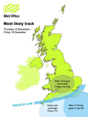
Please see below a MetO Video update
edit on 14/12/11 by jrmcleod because: (no reason given)
reply to post by BRITWARRIOR
Please see below my rudimentary "paint job" of where i think the 2 main areas of concern will be during Late Thurs/Friday
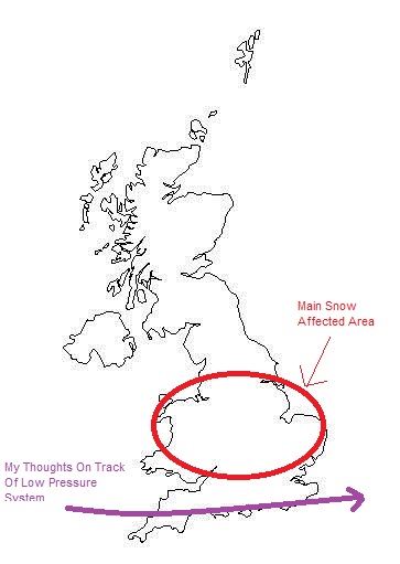
Please see below my rudimentary "paint job" of where i think the 2 main areas of concern will be during Late Thurs/Friday

How spooky is this...wonder if the MetO have someone subscribed to this thread....lol
reply to post by jrmcleod
About 956 feet above sea level.
Met office obviously hates me thus far.
About 956 feet above sea level.
Met office obviously hates me thus far.
edit on 14-12-2011 by Suspiria because: (no reason given)
Originally posted by jrmcleod
reply to post by BRITWARRIOR
Please see below my rudimentary "paint job" of where i think the 2 main areas of concern will be during Late Thurs/Friday
Yep that's pretty much along the lines of what i was thinking, if i was to have a guess based on all models and past events id track it slightly north a hundred miles or so, Just a hunch... with the center of the LP tracking up the Seven instead, come tomorrow 15:00, if it starts to drop south then i guess my bets dead in the water, if it does tho, We would no doubt see some high winds & server gales for the South Coast again & Snow, some heavy accumulations over the downs/higher ground,
So basically something like this...
img846.imageshack.us...

So enters up the Seven and Exits Norfolk by "The Wash", id put it 50-100miles north of MetO first possible track, i was really surprised to see that just now actually, second possible track to be honest looks exactly like mine and the first like yours LOL
Abit of a WTF moment there for me
edit on 14-12-2011 by BRITWARRIOR because: (no reason given)
reply to post by theguygeeza
just had a word with wifey and she still insists the wind cycle was very unusual. i'll keep my ears unmuffled later on when i'm out.
i'm not too sure about the installations you mentioned. i don't think they'll come down in the wind. regarding the hydraulic fracturing, yes, there are more developements on that one.
www.abovetopsecret.com...
any replies from the authorities on that matter may well be wind related!
f
new topics
-
Who guards the guards
US Political Madness: 33 minutes ago -
Has Tesla manipulated data logs to cover up auto pilot crash?
Automotive Discussion: 2 hours ago -
whistleblower Captain Bill Uhouse on the Kingman UFO recovery
Aliens and UFOs: 7 hours ago -
1980s Arcade
General Chit Chat: 9 hours ago -
Deadpool and Wolverine
Movies: 10 hours ago -
Teenager makes chess history becoming the youngest challenger for the world championship crown
Other Current Events: 11 hours ago
top topics
-
Lawsuit Seeks to ‘Ban the Jab’ in Florida
Diseases and Pandemics: 14 hours ago, 20 flags -
Starburst galaxy M82 - Webb Vs Hubble
Space Exploration: 16 hours ago, 13 flags -
CIA botched its handling of sexual assault allegations, House intel report says
Breaking Alternative News: 12 hours ago, 8 flags -
15 Unhealthiest Sodas On The Market
Health & Wellness: 16 hours ago, 6 flags -
whistleblower Captain Bill Uhouse on the Kingman UFO recovery
Aliens and UFOs: 7 hours ago, 6 flags -
1980s Arcade
General Chit Chat: 9 hours ago, 4 flags -
Deadpool and Wolverine
Movies: 10 hours ago, 3 flags -
Teenager makes chess history becoming the youngest challenger for the world championship crown
Other Current Events: 11 hours ago, 3 flags -
Who guards the guards
US Political Madness: 33 minutes ago, 1 flags -
Has Tesla manipulated data logs to cover up auto pilot crash?
Automotive Discussion: 2 hours ago, 0 flags
active topics
-
-@TH3WH17ERABB17- -Q- ---TIME TO SHOW THE WORLD--- -Part- --44--
Dissecting Disinformation • 607 • : IndieA -
House Overwhelmingly Passes Funding for Ukraine, Israel and Taiwan
US Political Madness • 56 • : Justoneman -
Michael Avenatti Says He Will Testify FOR Trump
US Political Madness • 60 • : Justoneman -
The Superstition of Full Moons Filling Hospitals Turns Out To Be True!
Medical Issues & Conspiracies • 17 • : Scratchpost -
1980s Arcade
General Chit Chat • 9 • : theatreboy -
New whistleblower Jason Sands speaks on Twitter Spaces last night.
Aliens and UFOs • 40 • : seekshelter -
Who guards the guards
US Political Madness • 0 • : annonentity -
Man possibly killed by werewolf in Texas
Cryptozoology • 27 • : burritocat -
Candidate TRUMP Now Has Crazy Judge JUAN MERCHAN After Him - The Stormy Daniels Hush-Money Case.
Political Conspiracies • 620 • : Threadbarer -
Starburst galaxy M82 - Webb Vs Hubble
Space Exploration • 5 • : Justoneman