It looks like you're using an Ad Blocker.
Please white-list or disable AboveTopSecret.com in your ad-blocking tool.
Thank you.
Some features of ATS will be disabled while you continue to use an ad-blocker.

Advanced Warning of Double Major Storms For UK Next Week - In Depth Analysis (Be Prepared)
page: 31share:
reply to post by ALOSTSOUL
I live in South East London.
I was only remarking to my eldest DD about a flash we saw tonight. No sound, so I thought maybe it was a railway flash but I remembered there was no railway lines in that direction. We saw it in the South East direction of where we live. My eldest saw a flash yesterday from exactly the same direction. (I didn't believe her but now I do. Guilty giggle.)
In fact while we were out shopping my youngest pointed out a weird star. I said that's not a star as it wasn't twinkling and its mag. would have been as bright as Venus. It was stationary and then while I was pointing at it, it turned into a massive sphere of dull light and then faded away. So we saw a UFO. Seen loads, I just yell at them to p**s off. (I did it right in front of a woman. Cringe)
We saw this UFO about 8pm above Orpington.
So maybe there is a battle going on? Who knows.
(Or maybe my youngest dream is coming true? She dreamt that Stonehenge was sending light skywards. Maybe the stone circles are giving off highly charged particles and lighting up the sky. I think of all the crazy stuff first then get to the boring conclusions later, keeps my brain active.LOL)
Still hoping Friday is not a nasty storm as I'm not ready; the gardens are full of rubbish waiting to go to the dump. And something hit my window last night already but no damage, just our nerves.
Peace
reply to post by jrmcleod
Hi, report from Barrow-in-Furness (South West coast of Cumbria)
We have had strong winds, rain, hail & sleet for the past 48 hours. There seems to be no stopping this, it has not calmed at all. I took my 38kg Old Country Bulldog for a jog up the highest hill in our area and back down to the coast last night at approximately 20:00. We had a struggle keeping upright at some points, I was wearing a 5.11 tactical multi layer jacket, joggers, water proof pants, thermal socks, cat boots, leather gloves, a balaclava & still felt the cold tremendously, many small objects flew past us, pieces of fences, parts of trees, for sale signs (I was in the countryside ?) ect.
Upon making it home I put the gas fire on to warm us through but had to turn it off as the winds were making it dance a little too much for my liking. I decided to put the central heating on only to spend 30 or so minutes trying to light the pilot light, I finally got it lit for it to blow out again when the darn heatings cycle stopped at 1:00 am, this is a very worrying storm.
I hope that when this storm blows itself out there is not another to follow on Friday as predicted like this first. It is still going strong even now, and looks to be in for the day again. I noticed a few slates missing from roofs in the suburb of the town I am living in at the moment, a friend owns a small roofing company here, he is all too pleased for the extra work over December, I'm not sure us that will suffer the damages are as pleased though.
I checked the BBC website for a weather report for our area yesterday and they reported light showers with mild winds (laugh out loud) don't you just love the main stream media. I am prepared for a worst case scenario whatever that may be anyway's. I have plenty of bottled water, rations, standard medications, a bug out bag & legal means of protection if Freud is not a deterrent enough & now have candles in every room and keep my trusty Zippo lighter in my pocket constantly. I keep filling my bath with water also for my Freud to drink in case of a power outage & the pumping stations failing.
I remember the storms of 87 (I was 7 by the way) as family and I were camping on an isle called Piel, we survived that as we were all asked to stay in a big bell tent the authorities on the isle had & had erected for such a incident. Our tents however did not survive and we were evacuated off the isle as soon as it was safe to do so.
Quick update I have just listened to the sounds of the first plane I have noticed in the past 48 hours landing on the island of Walneys air strip so things may be dying down, if small B.A.E business planes can land on a small strip it can not be that bad any more. However it sounds just as bad to me in this second floor flat as it has since this storm blew in (please excuse the pun, as it was not intended)
I hope if this storm dies down it does not become the quiet before the second storm as Mcleod predicted, the general public are not prepared as the MSM do not release warnings until the very last minute Luckily I cook on gas so if power does go down I am able to offer help to people with babies I know who rely only on electricity & have planned to check on any old or lone vulnerable people if there is a worst case scenario.
I wish everybody well, safety, luck & peace.
reply to post by theguygeeza
pumping station? you must be round salthouse way. and was that birkrigg common you were tabbing on?
i was on the west coast of windy city last night as usual. no-one was around which is amusing as there is usually a handful of loiterers up to no good and posing. on guy drove down to the beach front, opened his door to let his poodle out, yanked it back in and drove off! good thing the doggy was on a lead!
anyway, its' good to know someone nearby has got their crap together!
regards fakedirt.
btw forgot to add.. there has been imo an unusual developement with the wind. also the wifey mentioned this and it has occured a handful of times now, last night and monday night. there was a strange pulsating cycle when the wind was blowing. it was a consistent cycle of about 4/5 second duration and then repeat. just wondering if anyone elso picked up on it. happened down the beach as well as outside home. cheerz
edit on 14-12-2011 by
fakedirt because: extra extra reeds bend in the wind!
Friday 16th Storm Update
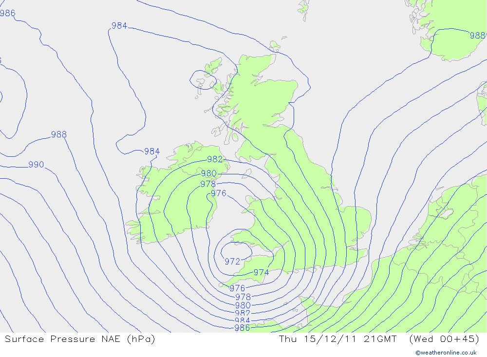
Now that Thursday's LP is out of the way we can begin to focus somewhat more of our attention to the potential for Friday. In terms of meteorology, it has and still is a very difficult time for forecasting. Although there is agreement that a storm system will move into the UK in the early hours of Friday 16th, there is still a great deal of uncertainty to the track of the system.
I have looked at 10 different models and their outputs, of the 10, 2 don't have a storm system at all and 8 do. So there is an agreement of 80%.
The confusing part though is that none of the 8 models have the same path of the storm, and a difference of 100 miles is a huge amount given the projected path of the storm. So far, of the 8 storms we have a difference of around 15mb's in central pressure...the lowest forecast being 970mb and the highest around 984mb. Some models are pushing the storm mainly over the North coast of France, some are pulling it close to the Severn Estuary, and others directly through the channel.
If you have been watching the weather on TV recently you will see by the forecasters response to this storm just how difficult it is going to be to predict.
The term "Fantasy Island (FI)" refers to a period of time that is literally, fantasy. The nature of weather forecasting allows this term to be used quite aptly. With this storm, it would probably be safe to say that anything forecast greater that 24 hours from the storms impact would be classed as FI. There's just too many differing opinions. So bearing this in mind, it would be worthwhile for you to note that anything i post below is most definitely subject to change, even at t-minus 48 hours.
There is also a surprise in the models that there is a slight possibility of quite a big snow event for the Midlands once the storm passes through, possibly Friday night Saturday morning, but whether or not the air is cold enough for snow will remain to be seen. So this is just a heads up. If conditions are right we could see potentially 10+ cm's anywhere from around Manchester south to Cardiff then east to the North See. Obviously if your above around 200m you'll stand a better chance of some quite significant snow. Will update on this probably tomorrow though!
Here we see the potential location of the storm on Thursday Night at 2100.
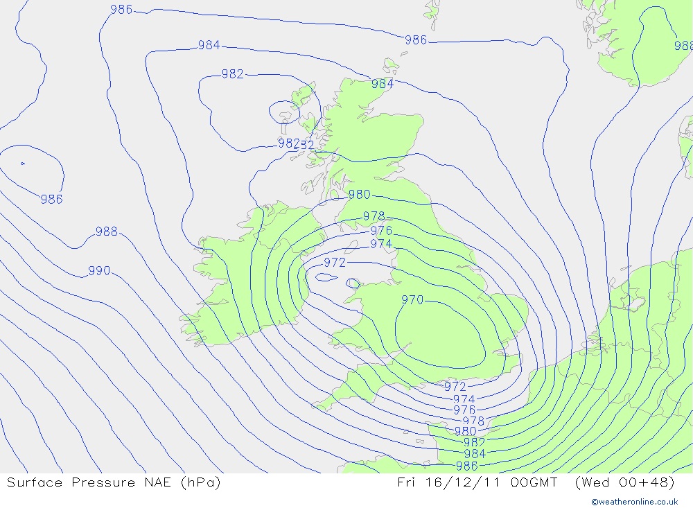
Here we have the storm pushing through the centre of England at Midnight on Thursday Night.
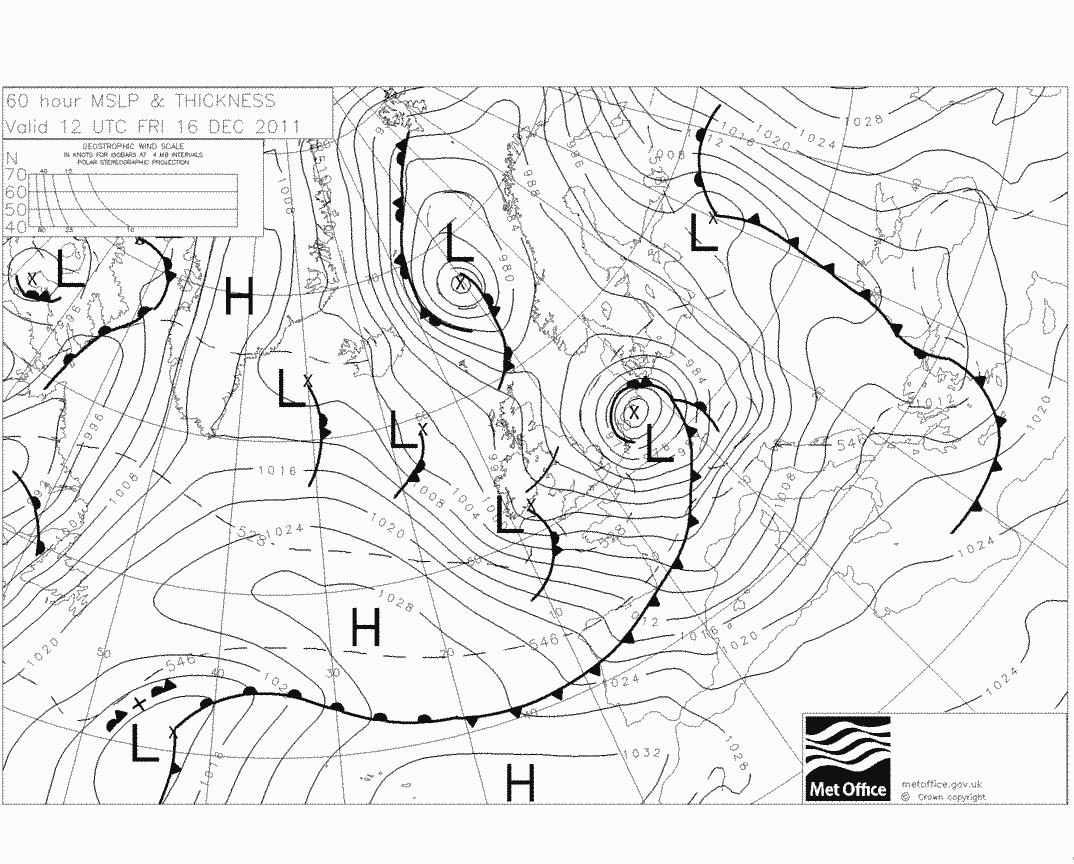
Here we have the storm at Noon on Friday, out in the North Sea, however, what is worth noting on this image is the line that crosses the UK across north Wales. This is what we need to watch for snow potential. This is a small front that could bring snow.
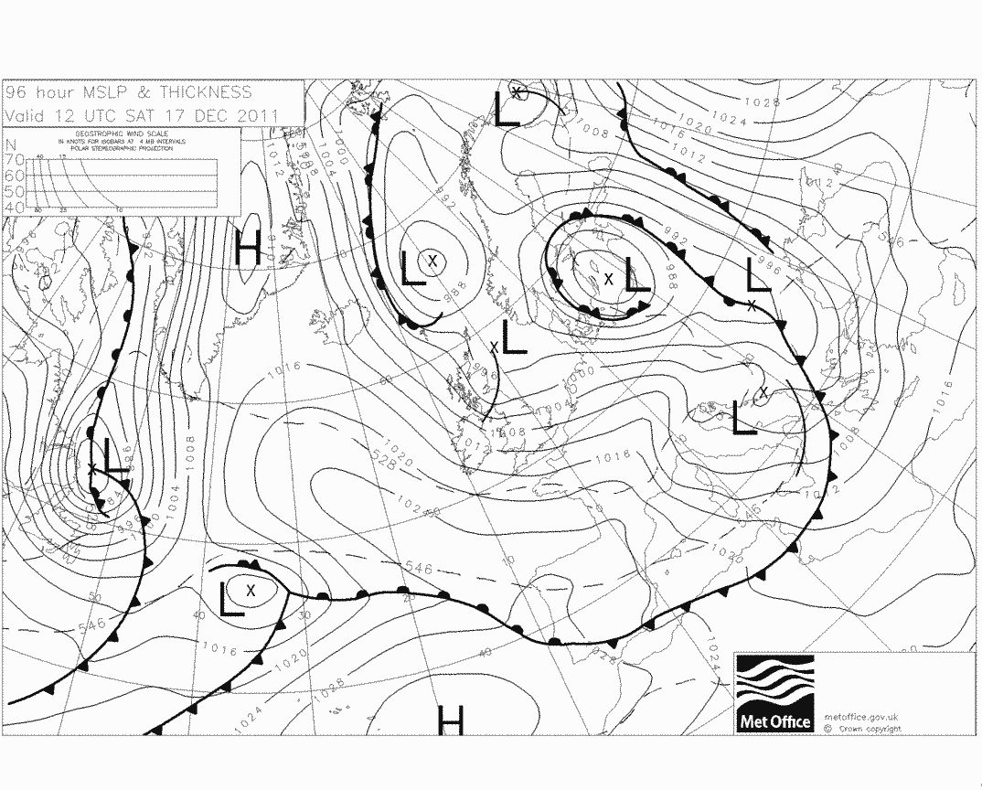
Next you can see the LP well past Denmark, on its way to Russia, but as with the above image, we see yet another line swathing the country on Saturday stretching from NI to the East of Scotland. This again is another front that has the possibility of snow but its highly uncertain at the moment.
Unfortunately i can't really elaborate on anything further yet, simply because until the track is nailed down, its almost impossible to give adequate wind speeds or potential gusts and their location. The difference of 100 miles could mean its North France that get the brunt or its the South Coast and SE that gets it. Hopefully todays model outputs can come into better alignment and we can take it from there.
Now that Thursday's LP is out of the way we can begin to focus somewhat more of our attention to the potential for Friday. In terms of meteorology, it has and still is a very difficult time for forecasting. Although there is agreement that a storm system will move into the UK in the early hours of Friday 16th, there is still a great deal of uncertainty to the track of the system.
I have looked at 10 different models and their outputs, of the 10, 2 don't have a storm system at all and 8 do. So there is an agreement of 80%.
The confusing part though is that none of the 8 models have the same path of the storm, and a difference of 100 miles is a huge amount given the projected path of the storm. So far, of the 8 storms we have a difference of around 15mb's in central pressure...the lowest forecast being 970mb and the highest around 984mb. Some models are pushing the storm mainly over the North coast of France, some are pulling it close to the Severn Estuary, and others directly through the channel.
If you have been watching the weather on TV recently you will see by the forecasters response to this storm just how difficult it is going to be to predict.
The term "Fantasy Island (FI)" refers to a period of time that is literally, fantasy. The nature of weather forecasting allows this term to be used quite aptly. With this storm, it would probably be safe to say that anything forecast greater that 24 hours from the storms impact would be classed as FI. There's just too many differing opinions. So bearing this in mind, it would be worthwhile for you to note that anything i post below is most definitely subject to change, even at t-minus 48 hours.
There is also a surprise in the models that there is a slight possibility of quite a big snow event for the Midlands once the storm passes through, possibly Friday night Saturday morning, but whether or not the air is cold enough for snow will remain to be seen. So this is just a heads up. If conditions are right we could see potentially 10+ cm's anywhere from around Manchester south to Cardiff then east to the North See. Obviously if your above around 200m you'll stand a better chance of some quite significant snow. Will update on this probably tomorrow though!
Here we see the potential location of the storm on Thursday Night at 2100.
Here we have the storm pushing through the centre of England at Midnight on Thursday Night.
Here we have the storm at Noon on Friday, out in the North Sea, however, what is worth noting on this image is the line that crosses the UK across north Wales. This is what we need to watch for snow potential. This is a small front that could bring snow.
Next you can see the LP well past Denmark, on its way to Russia, but as with the above image, we see yet another line swathing the country on Saturday stretching from NI to the East of Scotland. This again is another front that has the possibility of snow but its highly uncertain at the moment.
Unfortunately i can't really elaborate on anything further yet, simply because until the track is nailed down, its almost impossible to give adequate wind speeds or potential gusts and their location. The difference of 100 miles could mean its North France that get the brunt or its the South Coast and SE that gets it. Hopefully todays model outputs can come into better alignment and we can take it from there.
reply to post by pazcat
I actually saw something odd last night. It seemed too low and only seemed to be lit up by the street lights, so I assumed it was a dive bombing bat.
It's a beautiful day...Not a sniff of a fecking snow cloud.
I actually saw something odd last night. It seemed too low and only seemed to be lit up by the street lights, so I assumed it was a dive bombing bat.
It's a beautiful day...Not a sniff of a fecking snow cloud.
edit on 14-12-2011 by Suspiria because: (no reason given)
Yeah ! Finally got my hands on a PC.
Well all is calm here now and the cleaning up begins. Was a rough day yesterday. Started off with thunderstorms around 4am. we don't get that many thunderstorms here (rarely in fact). When i peered outside in the dark at 0700 GMT I thought it was going to be just another passing storm, of which we do get plenty of at this time of the year and up until about 1300 it was just that, a passing storm. the one problem was.. it didn't really pass.I got stronger.
It has to be remembered at this stage that everything is relative to what you are used to. Yeah I read all the posts in this thread and will make no comment on many of them but for us here on the NW coast of Ireland it was a fairly big storm.
Winds picked up from around 1300 and sustained wind-speed reached 40knots yesterday afternoon with a 75knot gust recorded soon after. The wind combined with increasing heavy showers of hail sleet and rain (I'm just above sea level so snow didn't feature) brought down dozens of trees and cut off power and mobile phone access for a few hours at the height of the storm.
In mid afternoon the new Irish wave height record was set about 60 miles off the coast from me. 67 feet ! Now that's what I call a big wave. (incidentally funding for the buoy that recorded that along with the other maritime buoys round the coast is to be withdrawn in 2 weeks... we'll see if that happens now.)
The storm continued until well after dark here and was still blowing at about Force 8-9 at 2300 accompanied by constant driving rain.
Here are a few local links that might give you an insight into yesterday.
Monster Wave
MUST BE A DONEGAL WINTER!
Donegal Flooding
More Donegal Flooding
My friends,
Update from Sedbergh, Cumbria. The wind has dropped big time but the rain has taken over ten fold. Havent seen this much rain in a long time lol
Be safe be well,
Spiro
Update from Sedbergh, Cumbria. The wind has dropped big time but the rain has taken over ten fold. Havent seen this much rain in a long time lol
Be safe be well,
Spiro
One positive thing with regards to these storms. Means one goes to her bed early with her other half.
I notice however there are two low pressures over the UK one in the north and one in the south, Going to be an interesting few days to say the least.
I notice however there are two low pressures over the UK one in the north and one in the south, Going to be an interesting few days to say the least.
reply to post by Suspiria
We had a few tad droplets of snow today. Did not lay long melted as as soon as it hit the ground
Oh wells we still might get a white Christmas. Those in the north will have one that is for sure.
We had a few tad droplets of snow today. Did not lay long melted as as soon as it hit the ground
Oh wells we still might get a white Christmas. Those in the north will have one that is for sure.
reply to post by jrmcleod
And the low lurking off the coast of Canada? Looks like that could be here just in time for Xmas. If the high pressure from the Arctic drops in behind this upcoming system and gives us a a blast of Arctic air, could this mean potential for heavy snow when this new low system reaches us?
And the low lurking off the coast of Canada? Looks like that could be here just in time for Xmas. If the high pressure from the Arctic drops in behind this upcoming system and gives us a a blast of Arctic air, could this mean potential for heavy snow when this new low system reaches us?
Originally posted by Laurauk
One positive thing with regards to these storms. Means one goes to her bed early with her other half.
And those of us without another half have to make do with the TV. Oh wait, the satellite signal has gone!
I live in West Yorkshire on the border with Lancashire. We've just had a mini blizzard but so far it's not laying.
reply to post by starchild10
Is it travelling eastwards? (fingers crossed).
Nothing here yet but again it is brass monkeys today.
Is it travelling eastwards? (fingers crossed).
Nothing here yet but again it is brass monkeys today.
Bodmin, Cornwall 0500 hrs this morning. Heavy Snow and hail. Everything was white. This was accompanied by Lightning and very loud thunder. Still cold
at the moment with the occasional hail/rain but heavy at times.
Certainly an interesting night for sure
Certainly an interesting night for sure
reply to post by Spiro
It's strange that Spiro, it's the opposite here in Workington, no rain since early this morning, but still really windy. Not as bad as last night though. Shows how little distance in the UK is needed before the weather changes. Mind you, I'm on the coast. you will be further inland are you?
It's strange that Spiro, it's the opposite here in Workington, no rain since early this morning, but still really windy. Not as bad as last night though. Shows how little distance in the UK is needed before the weather changes. Mind you, I'm on the coast. you will be further inland are you?
reply to post by fakedirt
Hello fakedirt, thank you for the reply. The gas terminal is a worry as is Sellafield up the road too & the other dangers surrounding this area. I am suspicious of the drilling for gas that is happening from Blackpool to Millom as well.
It is good to hear facts from somebody else in our area. I know Birkrigg Common very well as it is the nearest druids circle in this area other than Kendal. The super moon early this year from up there was amazing, Freud & I camped out there to stop people from abusing the circle as they have in the past. People pulled over & looked but when they noticed the dog sat on the rocks looking out on the circle (not I as I wore camouflaged kit) they stayed away & drank their beers or whatever they were doing in their vans & cars. We must of spooked them as I intended as he sat to attention with me for hours poor thing.
Sorry OP (Mcleod) & Mods for the off topic there.
I did not notice anything strange in the winds last night but it was awkward as we were jogging, the winds though were relentless & we gave up jogging after 3 miles
The winds in our part of this small rock we once called Great Britain (for those of you on other parts of our Island or in other Countries) have calmed slightly. The rain though however, is still coming in short but intense bursts. I really hope this is not the calm before the next system moves in :/
Thank you OP for giving us all the heads up about this, I have linked this thread to that information gathering program called face book to try & warn people to keep an eye on those in need and to let people know to expect bad times. Not many people have taken notice though, a few have and have taken precautions and a few have panicked as they do not take the time to read all the posts or simply do not understand the charts or what is being said. Still though at least a few take notice & prepare, at least I am doing as our motto says & am trying to open peoples eyes & deny ignorance.
I guesstimate that gusts are on average 20-30mph now so some normality is back and things do not sound as menacing as they have over the past few days. All we can do is stay tuned & work together piecing this puzzle to try and solve it so we are able to warn those that may be in danger.
I am really thankful that I stumbled upon this site looking up information on the Mayans a few years back, there are some Great People on here who are dedicated & determined to spreading the denial of ignorance message. You Mods are fair too and without you's some of the off topic posts if they were left would put an educated new comer off.
Thanks once again OP I look forward to forth coming updates or should that be I am dreading them (laughs out loud)
I will take this opportunity to wish us all, whatever your beliefs may be a Merry Christmas/Happy Holidays & all the best for 2012.
May safety, peace & luck be with us all.
Originally posted by fiftyfifty
reply to post by jrmcleod
And the low lurking off the coast of Canada? Looks like that could be here just in time for Xmas. If the high pressure from the Arctic drops in behind this upcoming system and gives us a a blast of Arctic air, could this mean potential for heavy snow when this new low system reaches us?
I know the LP you are referring too but even at 11 days out, forecasting the position of that LP in relation to the other systems in the region would be like picking the right numbers this Saturday!!!!
I think the general consensus with the models is that the gap left vacant once Fridays storm moves out of the way will be dominated by the High Pressure of the Azores, which is most often the case in these scenarios. Now there is differing opinions in the weather community as to how far north the milder air from the Azores will travel. Will it travel up to the UK? If it does will it keep hold?
The LP from Canada that you refer looks like, if the models are accurate (which they aren't at this stage), show the LP being squeezed north over "the top" of the Azores high pressure. The LP would track north over Iceland and then up into the Arctic.
My personal opinion is a mixed scenario of 2 possible outcomes.
1. The Azores high stretches and holds on over the UK until after Christmas giving the south of the UK one of, if not the, mildest Christmas on record. Possibly even up to the 15oC mark for the channel islands. (Bad Outcome)
2. The Azores high is displaced by any LP's traveling east over the next 10 days bringing an increased risk of snowfall to the UK from NW streamers (Good outcome)
I don't really know which of the outcomes will come to fruition but one thing is for sure...one of those outcomes will be accurate...but which one?
reply to post by jrmcleod
Thanks for a great answer! I'll keep a close eye on it. I have faith in your predictions more then I do with the MetO. Keep up the good work!
Thanks for a great answer! I'll keep a close eye on it. I have faith in your predictions more then I do with the MetO. Keep up the good work!
Originally posted by Flavian
reply to post by starchild10
Is it travelling eastwards? (fingers crossed).
Nothing here yet but again it is brass monkeys today.
We keep having bouts of hail and sleet - horizontal when the wind is up. And yes from west to east. I'm just waiting for a lull to take the dog out!
Having dug a hole a couple of weeks back and left it (as British workmen do), Transco has chosen today to get back on the job. Typical.
Good evening everyone, greetings from warm and humid Russia.
I hope you all stay safe and suffer minimal property damages. "Hurricane Omelette" rages on in the UK, and more low pressures are on their way. But how did the OP first post prediction turn out? Would be lovely if we had a predicted storm track on map with mbars at each point of the storm track line compared in different colors with the storm track that came to be. I am most curious to see this happen.
The rests of what pounded you all the last day are now giving Moscow a fever. We had +1 C today, tomorrow and the next days we are forecast a whopping +5 C! Meaning all this lovely snow will melt in time for Christmas. I blame it on the low pressure circulation dragging in a tongue of hot air from the Black Sea. A weather station would be great now to sate my meteorological curiosity. But those things are somewhat hard to get here.
edit
on 14/12/2011 by RumET because: Added some greetings.
new topics
-
Thousands Of Young Ukrainian Men Trying To Flee The Country To Avoid Conscription And The War
Other Current Events: 13 minutes ago -
12 jurors selected in Trump criminal trial
US Political Madness: 2 hours ago -
Iran launches Retalliation Strike 4.18.24
World War Three: 3 hours ago -
Israeli Missile Strikes in Iran, Explosions in Syria + Iraq
World War Three: 3 hours ago -
George Knapp AMA on DI
Area 51 and other Facilities: 9 hours ago -
Not Aliens but a Nazi Occult Inspired and then Science Rendered Design.
Aliens and UFOs: 9 hours ago -
Louisiana Lawmakers Seek to Limit Public Access to Government Records
Political Issues: 11 hours ago
top topics
-
BREAKING: O’Keefe Media Uncovers who is really running the White House
US Political Madness: 16 hours ago, 25 flags -
George Knapp AMA on DI
Area 51 and other Facilities: 9 hours ago, 24 flags -
Biden--My Uncle Was Eaten By Cannibals
US Political Madness: 17 hours ago, 19 flags -
Israeli Missile Strikes in Iran, Explosions in Syria + Iraq
World War Three: 3 hours ago, 12 flags -
"We're All Hamas" Heard at Columbia University Protests
Social Issues and Civil Unrest: 17 hours ago, 7 flags -
Louisiana Lawmakers Seek to Limit Public Access to Government Records
Political Issues: 11 hours ago, 7 flags -
Not Aliens but a Nazi Occult Inspired and then Science Rendered Design.
Aliens and UFOs: 9 hours ago, 5 flags -
So I saw about 30 UFOs in formation last night.
Aliens and UFOs: 14 hours ago, 5 flags -
Iran launches Retalliation Strike 4.18.24
World War Three: 3 hours ago, 5 flags -
Do we live in a simulation similar to The Matrix 1999?
ATS Skunk Works: 15 hours ago, 4 flags
active topics
-
Israeli Missile Strikes in Iran, Explosions in Syria + Iraq
World War Three • 51 • : TheMisguidedAngel -
MULTIPLE SKYMASTER MESSAGES GOING OUT
World War Three • 47 • : SchrodingersRat -
Elites disapearing
Political Conspiracies • 30 • : SchrodingersRat -
Not Aliens but a Nazi Occult Inspired and then Science Rendered Design.
Aliens and UFOs • 10 • : OmegaLogos -
12 jurors selected in Trump criminal trial
US Political Madness • 21 • : VictorVonDoom -
British TV Presenter Refuses To Use Guest's Preferred Pronouns
Education and Media • 64 • : Degradation33 -
Iran launches Retalliation Strike 4.18.24
World War Three • 14 • : Cloudbuster1 -
Thousands Of Young Ukrainian Men Trying To Flee The Country To Avoid Conscription And The War
Other Current Events • 0 • : Consvoli -
African "Newcomers" Tell NYC They Don't Like the Free Food or Shelter They've Been Given
Social Issues and Civil Unrest • 17 • : SchrodingersRat -
Canadian Forces bow out and loose interest in UFO’s
Aliens and UFOs • 20 • : Ophiuchus1