It looks like you're using an Ad Blocker.
Please white-list or disable AboveTopSecret.com in your ad-blocking tool.
Thank you.
Some features of ATS will be disabled while you continue to use an ad-blocker.

Advanced Warning of Double Major Storms For UK Next Week - In Depth Analysis (Be Prepared)
page: 28share:
reply to post by Free4Ever2
Any footage of any trampolines flying past your window will you post them please thank you very much
But other than that stay safe!
Any footage of any trampolines flying past your window will you post them please thank you very much
But other than that stay safe!
reply to post by BRITWARRIOR
its mild with patchy cloud and sunny spells here in lancs =) no sign of any harsh weather hoooorrahhh
its mild with patchy cloud and sunny spells here in lancs =) no sign of any harsh weather hoooorrahhh
Looking very dark over Milton Keynes now, and it's just started to rain quite heavy.
Is there a free download i can get to watch storms develop.
Oh....thanks for the heads up OP
Is there a free download i can get to watch storms develop.
Oh....thanks for the heads up OP
It's blowing a gale here in Ayrshire at the moment. I'd say it is equal to Hurricane Bawbag, and it's just starting. I think Bawbag didn't have
a straight westerly, so it was different in a way. Either way, it'll be interesting to see it out. It's roaring right in off the coast.
It was incredibly windy on the M77 about an hour ago, so I'd avoid overtaking high sided vehicles.
Ooooooooo... There goes a Tesco flag....... Yay!!!
It was incredibly windy on the M77 about an hour ago, so I'd avoid overtaking high sided vehicles.
Ooooooooo... There goes a Tesco flag....... Yay!!!
Originally posted by moosevernel
reply to post by BRITWARRIOR
its mild with patchy cloud and sunny spells here in lancs =) no sign of any harsh weather hoooorrahhh
We have some heavy snow showers coming in from the west
Originally posted by andypb
Looking very dark over Milton Keynes now, and it's just started to rain quite heavy.
Is there a free download i can get to watch storms develop.
Oh....thanks for the heads up OP
I'm on the other side of it, its a wall of darkness, coming in fast to,
Watch on here
www.raintoday.co.uk...
Just hit.... Absolutely battering it down, the leading edge to that was intense, sleet... not snow this time
edit on 13-12-2011 by
BRITWARRIOR because: (no reason given)
reply to post by Laurauk
not yet but ive got my eagle eyes on next doors trampoline haha!
this is pretty wild here tbh! almost as bad as last week!
Should make for an interesting albeit powerless evening
not yet but ive got my eagle eyes on next doors trampoline haha!
this is pretty wild here tbh! almost as bad as last week!
Should make for an interesting albeit powerless evening
reply to post by andypb
Not really anything that will give you real time viewing of the storm. There are plenty of sites around that can provide you with current or very recent information. Some links are below:
Satellite View
Precipitation Radar
Multi Use Radar/Sat Images Site
Not really anything that will give you real time viewing of the storm. There are plenty of sites around that can provide you with current or very recent information. Some links are below:
Satellite View
Precipitation Radar
Multi Use Radar/Sat Images Site
reply to post by jrmcleod
Thanks for that OP, i was thinking not of a live feed so to speak, but just something
i could download to keep track on my pc.
Cheers.
Thanks for that OP, i was thinking not of a live feed so to speak, but just something
i could download to keep track on my pc.
Cheers.
OP - back on page 22 you posted that great SAT24 link - this is the one I've been referring back to...question is , is that swirly almost question
mark like system top left of Britain the next front they're talking about for Thursday/Friday ? It certainly looks a lot meaner than yesterdays !
[impatiently taps foot awaiting for Friday to arrive]
Good supporting data, at least - ill give you that.
Good supporting data, at least - ill give you that.
Originally posted by andypb
Looking very dark over Milton Keynes now, and it's just started to rain quite heavy.
Is there a free download i can get to watch storms develop.
Oh....thanks for the heads up OP
Dear Andy.
Go ahead and familiarize yourself with ZyGRIB it is a program, which is free and allows you to feel like a real meteorologist. To keep up with he storm developments you can choose to download free isobar and wind data. And they become available as soon as they are taken I believe, so it is a near real-time system. I do hope that my post helps helps. Perhaps this posting will spark some interest in meteorology and I can finally have someone to talk with.
This Hurricane Omelette is getting strong, my humble prediction is that it will strengthen in the night hours and move South East. Let's see how good my prediction skills are. That is why I absolutely love meteorology. You can predict stuff without being painted a a silly psychic, or UFO contacteur.
PS! I am still looking for WRF CUDA compiling help on my computer, thank you.
Originally posted by slidingdoor
OP - back on page 22 you posted that great SAT24 link - this is the one I've been referring back to...question is , is that swirly almost question mark like system top left of Britain the next front they're talking about for Thursday/Friday ? It certainly looks a lot meaner than yesterdays !
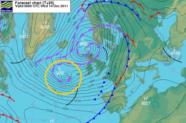
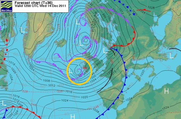
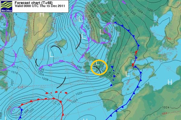
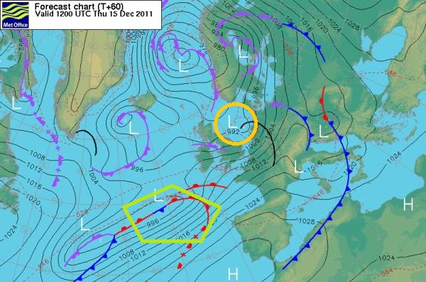
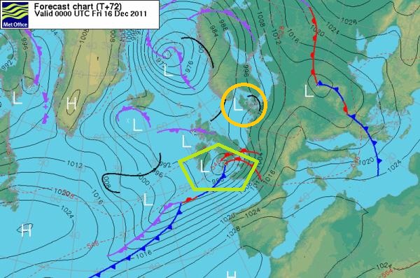
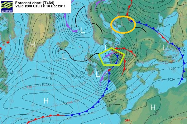
No, thats not what they are looking at. What you are seeing on the sat24 radar is detailed below. The Orange circle denote the circulation you see currently on Sat24. The Green pentagon is the track and formation of the storm for Friday. Have posted the charts for 12 hour intervals.
reply to post by RumET
Great, thanks for that, i'm a total beginner, but always found weather to be interesting.
I will download now, and start learning.
Many thanks
Great, thanks for that, i'm a total beginner, but always found weather to be interesting.
I will download now, and start learning.
Many thanks
Many thanks Jrmcleod - Normandy for any French followers also looks in the path of this one.
A very informative and interesting thread , thank you.
A very informative and interesting thread , thank you.
Hear the thunder rumble, a sound from miles away
Is it getting nearer, or over for today
A flash of blinding light, electric in the skies
Looking out the window, it really hurts my eyes
After comes the rumble, the clash of cloud on cloud
Feel the floor vibrating, that one was really loud
Still more lightning flashes, it hit's the old oak tree
Lightning in the garden, now that's too close for me
I'm not far from Edinburgh Airport and right now I would say the wind is as bad as and maybe even worse than last weeks storm. My barometer is
reading lower than it got last week, currently at 28.3inhg which equates to 958mb and still falling.
It's really windy here in Angus (NE Scotland) - Id say it rivals the last storm! All the bridges are closed, so commuters have a very long journey
ahead of them. My lights keep flickering. I have to go out soon, hope it dies down a little! Its impossible to walk in just now.
Can we start calling this Hurricane Dobber yet?
We're getting really skelped with it now, big gusts, little bit of hail but mostly that freezing rain that the winds blows right into your face. Even my Typhoon Brolly™ was hopeless! It doesn't seem to be a kick in the a*se off last week's weather but I'm obviously no expert, I just like the extremes. I did see a forecast for heavy snow on the Met Office website, that would make my night. The DVDs, cheesy balls and ice cream and ready to roll.
We're getting really skelped with it now, big gusts, little bit of hail but mostly that freezing rain that the winds blows right into your face. Even my Typhoon Brolly™ was hopeless! It doesn't seem to be a kick in the a*se off last week's weather but I'm obviously no expert, I just like the extremes. I did see a forecast for heavy snow on the Met Office website, that would make my night. The DVDs, cheesy balls and ice cream and ready to roll.
new topics
-
HORRIBLE !! Russian Soldier Drinking Own Urine To Survive In Battle
World War Three: 1 hours ago -
Bobiverse
Fantasy & Science Fiction: 4 hours ago -
Florida man's trip overseas ends in shock over $143,000 T-Mobile phone bill
Social Issues and Civil Unrest: 4 hours ago -
Former Labour minister Frank Field dies aged 81
People: 6 hours ago -
SETI chief says US has no evidence for alien technology. 'And we never have'
Aliens and UFOs: 8 hours ago -
This is our Story
General Entertainment: 10 hours ago
top topics
-
President BIDEN Vows to Make Americans Pay More Federal Taxes in 2025 - Political Suicide.
2024 Elections: 12 hours ago, 16 flags -
One Flame Throwing Robot Dog for Christmas Please!
Weaponry: 17 hours ago, 6 flags -
Florida man's trip overseas ends in shock over $143,000 T-Mobile phone bill
Social Issues and Civil Unrest: 4 hours ago, 6 flags -
SETI chief says US has no evidence for alien technology. 'And we never have'
Aliens and UFOs: 8 hours ago, 5 flags -
Don't take advantage of people just because it seems easy it will backfire
Rant: 17 hours ago, 4 flags -
Ditching physical money
History: 17 hours ago, 4 flags -
Former Labour minister Frank Field dies aged 81
People: 6 hours ago, 4 flags -
Bobiverse
Fantasy & Science Fiction: 4 hours ago, 3 flags -
This is our Story
General Entertainment: 10 hours ago, 3 flags -
Ode to Artemis
General Chit Chat: 13 hours ago, 3 flags
active topics
-
Russia Ukraine Update Thread - part 3
World War Three • 5726 • : stu119 -
Thousands Of Young Ukrainian Men Trying To Flee The Country To Avoid Conscription And The War
Other Current Events • 129 • : yuppa -
One Flame Throwing Robot Dog for Christmas Please!
Weaponry • 10 • : ATruGod -
Breaking Baltimore, ship brings down bridge, mass casualties
Other Current Events • 477 • : ArMaP -
-@TH3WH17ERABB17- -Q- ---TIME TO SHOW THE WORLD--- -Part- --44--
Dissecting Disinformation • 644 • : cherokeetroy -
HORRIBLE !! Russian Soldier Drinking Own Urine To Survive In Battle
World War Three • 8 • : Astyanax -
New whistleblower Jason Sands speaks on Twitter Spaces last night.
Aliens and UFOs • 51 • : Ophiuchus1 -
The Reality of the Laser
Military Projects • 40 • : Zaphod58 -
President BIDEN Vows to Make Americans Pay More Federal Taxes in 2025 - Political Suicide.
2024 Elections • 67 • : UnderAether -
Windows tracking links to WEF and more:
New World Order • 21 • : milaganenogan