It looks like you're using an Ad Blocker.
Please white-list or disable AboveTopSecret.com in your ad-blocking tool.
Thank you.
Some features of ATS will be disabled while you continue to use an ad-blocker.

Advanced Warning of Double Major Storms For UK Next Week - In Depth Analysis (Be Prepared)
page: 20share:
reply to post by BRITWARRIOR
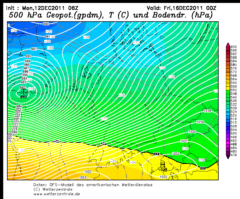
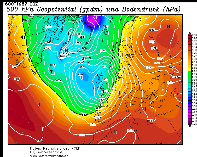
The GFS run has Fridays storm tracking a very similar route to the great storm of 1987, although not quite as deep. (see below). I strongly believe it will track slightly further north than the models are predicting. (just a hunch)
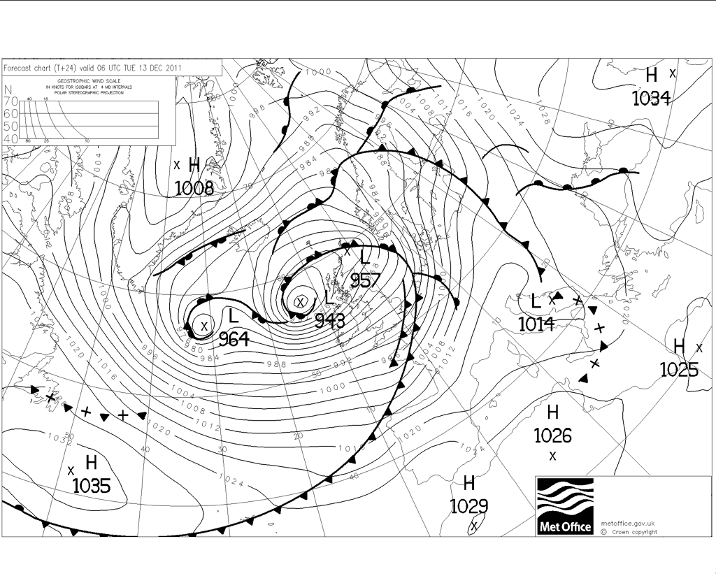
Back to Tuesday. The LP for Tuesday is still very much on track. It is forecast to have a central pressure of around 945mb, although i believe this will change when it hits land.
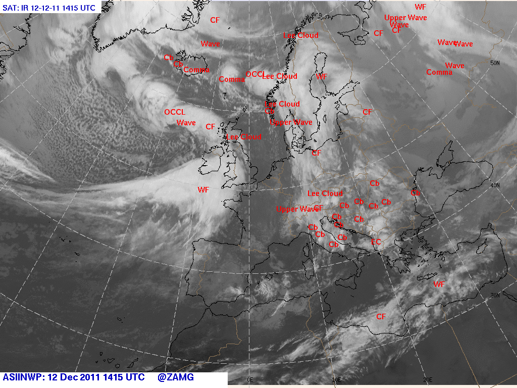
Here is a very recent image of the storm out to the NW of the UK
The GFS run has Fridays storm tracking a very similar route to the great storm of 1987, although not quite as deep. (see below). I strongly believe it will track slightly further north than the models are predicting. (just a hunch)
Back to Tuesday. The LP for Tuesday is still very much on track. It is forecast to have a central pressure of around 945mb, although i believe this will change when it hits land.
Here is a very recent image of the storm out to the NW of the UK
Originally posted by BRITWARRIOR
does anyone have a chart for that day or now the LP ? i sure some of you do
See Below
ooooh mummy according to meteo blue it looks like the majority of the high winds are going to smack straight up the english channel and our little
rock is in the way .
According to all of the weather forecasts I've been reading, this is all going to amount to a whole load of nothing. Perfectly normal weather for
this time of year.
Originally posted by RMFX1
According to all of the weather forecasts I've been reading, this is all going to amount to a whole load of nothing. Perfectly normal weather for this time of year.
Are you prepared to go on the news later tonight a say exactly that?
Brave man lol
As of now it does appear that on "some models" many models have it different, until they can all agree on something we just don't know, any prediction this far of is surely a bad move, as we know the lastest models are totally different to the ones last night, its all abit up in the air and far to early, as for tonight/tomorrows, it looks like it on
Originally posted by jrmcleod
The GFS run has Fridays storm tracking a very similar route to the great storm of 1987, although not quite as deep. (see below). I strongly believe it will track slightly further north than the models are predicting. (just a hunch)
Aye and GFS does still have it further south than other models - but I think there'll still be a lot of chopping and changing over the next couple of days. MetO currently has the centre running across the border, with ECM just a little further south over northern England (and some nasty winds hitting NE England as it exist into the N Sea). All good stuff
reply to post by RMFX1
Which forecasts would they be? The ones in the Dandy and Beano for 1974?
Anyway, rain just arriving here in Evesham and wind slowly picking up. I wonder if we'll see some snow tomorrow - if so, it'll be the first time since 2010!
The Irish Met office ( Met Eireann) make they main and most watched forecast after the main evening news. It will be interesting to see how they call
it. As of now we are looking at 130kmh ram gusts around 1300 GMT tomorrow. Thunder hail sleet snow all In the mix also. Friday still looking like a
non event. Storm not showing on latest models.
reply to post by TiocfaidhArLa
I agree, strongest winds for you (and esp N Ireland - not sure exactly where you are) tomorrow early afternoon, but I'd not right off Friday yet though I suspect Ireland will miss the worst then whatever happens. You could see some snow tomorrow.
I agree, strongest winds for you (and esp N Ireland - not sure exactly where you are) tomorrow early afternoon, but I'd not right off Friday yet though I suspect Ireland will miss the worst then whatever happens. You could see some snow tomorrow.
reply to post by Essan
Smart alec comments don't make your argument any stronger. Why don't you show me a weather forecast for later this week that says that something out of the ordinary will take place weather wise at any time anywhere in the UK this week.
Smart alec comments don't make your argument any stronger. Why don't you show me a weather forecast for later this week that says that something out of the ordinary will take place weather wise at any time anywhere in the UK this week.
Winds have picked up significantly here in West Cumbria, sounds like a train in my chimney, lol.
reply to post by woogleuk
Where exactly? Currently the Weather in Carlisle is mild to say the least.
6°C
14mph South Easterly
Humidity: 81%
Visibility: Good
Pressure: 988mb, Falling
Where exactly? Currently the Weather in Carlisle is mild to say the least.
6°C
14mph South Easterly
Humidity: 81%
Visibility: Good
Pressure: 988mb, Falling
Originally posted by RMFX1
reply to post by Essan
Smart alec comments don't make your argument any stronger. Why don't you show me a weather forecast for later this week that says that something out of the ordinary will take place weather wise at any time anywhere in the UK this week.
And neither do ignorant posts
How about you show us all some evidence of it NOT first?
While we all here are all keeping a very close eye on the models & up to date records of "NOW" via other local stations, we are simply discusing the weather as it comes in and speculating on the Friday model, there is no harm in that, its totally 50/50 at minute unless you have some other information you would like to share with us?
Originally posted by BRITWARRIOR
Originally posted by RMFX1
reply to post by Essan
Smart alec comments don't make your argument any stronger. Why don't you show me a weather forecast for later this week that says that something out of the ordinary will take place weather wise at any time anywhere in the UK this week.
And neither do ignorant posts
How about you show us all some evidence of it NOT first?
While we all here are all keeping a very close eye on the models & up to date records of "NOW" via other local stations, we are simply discusing the weather as it comes in and speculating on the Friday model, there is no harm in that, its totally 50/50 at minute unless you have some other information you would like to share with us?
How about you read actual forecasts instead of trying to interpret the charts yourself? Unless of course you're qualified to do so then by all means go ahead, but I for one cannot find a single weather forecast that says anything out of the ordinary for this time of year will take place. How is that ignorant? If you can prove otherwise then by all means..please do.
reply to post by RMFX1
Workington, on the coast, about 30 miles west of Carlisle, you need to look at the St. Bees head station for me, latest observation at 18:00 4.7 °C, SE 37 mph, Gust 49 mph, 985 hPa, Falling.
I can honestly say the gusts are definitely higher than 49mph, but that observation was an hour and a half ago and St. Bees is about 15 mile south of me.
EDIT:
19:00 4.3°C SE 40mph, Gusts 57mph, 982 hPa, Falling
edit on 12/12/11 by woogleuk because: (no reason given)
Wet and windy just outside of Burnley. Nothing out of the ordinary though...
Some very strong winds but about right for December up in the hills
Some very strong winds but about right for December up in the hills
Well it's getting pretty wet and windy here, I've just got back in from taking the dog for his two mile evening walk and the wind was blowing the
rain into my face fairly horizontally on the way back
Labradors are so expressive, Mine was clearly telling me as I was trying to dry him off that walkies tonight was not one of my better ideas He should know by now that I love walking in "bad" weather
Labradors are so expressive, Mine was clearly telling me as I was trying to dry him off that walkies tonight was not one of my better ideas He should know by now that I love walking in "bad" weather
Very wet and windy on the South coast, Portsmouth to be more precise.
Originally posted by RMFX1
Originally posted by BRITWARRIOR
Originally posted by RMFX1
reply to post by Essan
Smart alec comments don't make your argument any stronger. Why don't you show me a weather forecast for later this week that says that something out of the ordinary will take place weather wise at any time anywhere in the UK this week.
And neither do ignorant posts
How about you show us all some evidence of it NOT first?
While we all here are all keeping a very close eye on the models & up to date records of "NOW" via other local stations, we are simply discusing the weather as it comes in and speculating on the Friday model, there is no harm in that, its totally 50/50 at minute unless you have some other information you would like to share with us?
How about you read actual forecasts instead of trying to interpret the charts yourself? Unless of course you're qualified to do so then by all means go ahead, but I for one cannot find a single weather forecast that says anything out of the ordinary for this time of year will take place. How is that ignorant? If you can prove otherwise then by all means..please do.
I have a basic understanding of the charts yes, (i'm not a pro by any means) there really not that hard to read/understand at all, everybody uses these charts to make there forecasts, however they are just predictions based on lots & lots of super computers crunching numbers, nobody knows for certain until the day or at least a few hours before,
We all know Friday storm is a long way of theres no harm i discussing the updates being put out, i'm not entirely sure what your problem ius with it all,
If you would like to just read the forecast as it happens then by all means do so, but please respect that some of us like to follow & track these storm in advanced and also speculate on what the possibilities are,
Each to there own etc
Heavy rain and gusty here on Nw coast of Donegal, Ireland.
Still on course for gusts of 130kmh tomorrow noon.
UK MET office going on their own with the second storm which if it follows their projected path with whack Ireland full force on Thursday AND Friday. Sorry cant post the charts as I'm on the phone.
Still on course for gusts of 130kmh tomorrow noon.
UK MET office going on their own with the second storm which if it follows their projected path with whack Ireland full force on Thursday AND Friday. Sorry cant post the charts as I'm on the phone.
Originally posted by TiocfaidhArLa
Heavy rain and gusty here on Nw coast of Donegal, Ireland.
Still on course for gusts of 130kmh tomorrow noon.
UK MET office going on their own with the second storm which if it follows their projected path with whack Ireland full force on Thursday AND Friday. Sorry cant post the charts as I'm on the phone.
It looks like its going to be a wild one for you guys tomorrow, i think that's an upgrade from what was on the card just a few days ago for tomorrow
Keep us updated
new topics
-
Las Vegas UFO Spotting Teen Traumatized by Demon Creature in Backyard
Aliens and UFOs: 12 minutes ago -
2024 Pigeon Forge Rod Run - On the Strip (Video made for you)
Automotive Discussion: 1 hours ago -
Gaza Terrorists Attack US Humanitarian Pier During Construction
Middle East Issues: 1 hours ago -
The functionality of boldening and italics is clunky and no post char limit warning?
ATS Freshman's Forum: 2 hours ago -
Meadows, Giuliani Among 11 Indicted in Arizona in Latest 2020 Election Subversion Case
Mainstream News: 3 hours ago -
Massachusetts Drag Queen Leads Young Kids in Free Palestine Chant
Social Issues and Civil Unrest: 3 hours ago -
Weinstein's conviction overturned
Mainstream News: 4 hours ago -
Supreme Court Oral Arguments 4.25.2024 - Are PRESIDENTS IMMUNE From Later Being Prosecuted.
Above Politics: 6 hours ago -
Krystalnacht on today's most elite Universities?
Social Issues and Civil Unrest: 6 hours ago -
Chris Christie Wishes Death Upon Trump and Ramaswamy
Politicians & People: 6 hours ago
top topics
-
Krystalnacht on today's most elite Universities?
Social Issues and Civil Unrest: 6 hours ago, 8 flags -
Weinstein's conviction overturned
Mainstream News: 4 hours ago, 6 flags -
Supreme Court Oral Arguments 4.25.2024 - Are PRESIDENTS IMMUNE From Later Being Prosecuted.
Above Politics: 6 hours ago, 5 flags -
University of Texas Instantly Shuts Down Anti Israel Protests
Education and Media: 8 hours ago, 5 flags -
Massachusetts Drag Queen Leads Young Kids in Free Palestine Chant
Social Issues and Civil Unrest: 3 hours ago, 4 flags -
Meadows, Giuliani Among 11 Indicted in Arizona in Latest 2020 Election Subversion Case
Mainstream News: 3 hours ago, 4 flags -
Chris Christie Wishes Death Upon Trump and Ramaswamy
Politicians & People: 6 hours ago, 2 flags -
Any one suspicious of fever promotions events, major investor Goldman Sachs card only.
The Gray Area: 11 hours ago, 2 flags -
Gaza Terrorists Attack US Humanitarian Pier During Construction
Middle East Issues: 1 hours ago, 2 flags -
2024 Pigeon Forge Rod Run - On the Strip (Video made for you)
Automotive Discussion: 1 hours ago, 1 flags
active topics
-
Candidate TRUMP Now Has Crazy Judge JUAN MERCHAN After Him - The Stormy Daniels Hush-Money Case.
Political Conspiracies • 781 • : Threadbarer -
University of Texas Instantly Shuts Down Anti Israel Protests
Education and Media • 184 • : Consvoli -
God's Righteousness is Greater than Our Wrath
Religion, Faith, And Theology • 30 • : confuzedcitizen -
Chris Christie Wishes Death Upon Trump and Ramaswamy
Politicians & People • 19 • : DontTreadOnMe -
Supreme Court Oral Arguments 4.25.2024 - Are PRESIDENTS IMMUNE From Later Being Prosecuted.
Above Politics • 60 • : Annee -
Las Vegas UFO Spotting Teen Traumatized by Demon Creature in Backyard
Aliens and UFOs • 0 • : FlyersFan -
Breaking Baltimore, ship brings down bridge, mass casualties
Other Current Events • 489 • : Threadbarer -
-@TH3WH17ERABB17- -Q- ---TIME TO SHOW THE WORLD--- -Part- --44--
Dissecting Disinformation • 679 • : McTech2 -
Gaza Terrorists Attack US Humanitarian Pier During Construction
Middle East Issues • 15 • : Irishhaf -
Massachusetts Drag Queen Leads Young Kids in Free Palestine Chant
Social Issues and Civil Unrest • 9 • : theatreboy