It looks like you're using an Ad Blocker.
Please white-list or disable AboveTopSecret.com in your ad-blocking tool.
Thank you.
Some features of ATS will be disabled while you continue to use an ad-blocker.

Advanced Warning of Double Major Storms For UK Next Week - In Depth Analysis (Be Prepared)
page: 19share:
Originally posted by Flavian
reply to post by OneisOne
That is soooooooo cool. I can't wait, hence the childish response!
Thanks for letting me know what to expect. I can see me outside for hours in this if it actually happens.
I would be excited too!!! I hope you get some 'thundersnow', but nothing dangerous. I've been following these threads on the weather and hoping for the best for you all!!
Found a vid of a weather guy reacting to some 'thundersnow'. As you can see even the experienced weather people get excited.
Stay safe!
OiO
Originally posted by Flavian
reply to post by RumET
And thanks to you too RumET, your reply is much appreciated.
I always assumed Russia would have pretty incredible weather seeing as there is so much country for any systems to cross? (dramatic extremes either way).
It is definitely a country i have always been drawn too - in my mind there is much in common between the UK and Russia (in terms of the people rather than the State).
I can agree with that buddy i love me a bit of Russia =) At least if there is thundersnow it has the potential to be beautiful as well as destructive.
HAHAHAHAHAHA
Suddenly I'm not feeling too clever living on a hill overlooking the village with the whole west of the house completely exposed to nature.
Suddenly I'm not feeling too clever living on a hill overlooking the village with the whole west of the house completely exposed to nature.
reply to post by Flavian
Why, thank you Flavian. Much obliged, and you are welcome right back. Come visit us any time. ^^
Since most of Russia's landmass is a thousand kilometers away from any warm and humid sea I'm afraid the weather extremes that need warmth and humidity are simply not happening here. Though under rare conditions they can, and then the supercells grow vast on our large plains, somewhat like in the US. My record is 8 LP and 1 HP supercell in one summer (2008). Even saw a funnel cloud. But again, it's extraordinary to have anything more then a mildly severe thunderstorm over here. Europe attracts most of the bad weather to itself sadly. And I'm slowly withering without storms over here.
edit on 12/12/2011 by RumET because: Added my supercell record.
Just to let you all know the met have changed the weather warnings for the week and they are now as follows
Monday 12/12/2011
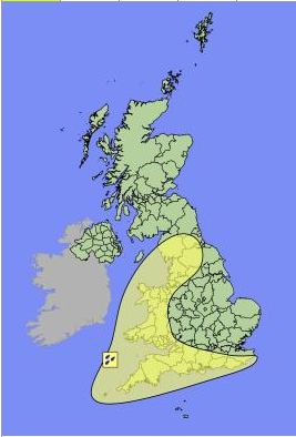
Showing weather warnings for heavy rain across extreme southern and western England and Wales. Beware of flooding in high risk areas.
Tuesday 13/12/2011
Showing much the same as Monday except with the addition snow warnings for Northern Ireland, Scotland and Northern England
Wednesday 14/12/2011
Same as Tuesday but without the Rain warnings.
Thursday 15/12/2011
This is where it gets interesting, this is a warning in place of winds for the entire of England, Wales, Northern Ireland and parts of Scotland and has been revised down from covering the entire UK. Hopefully Scotland can escape the brunt of this one.
Friday 16/12/2011
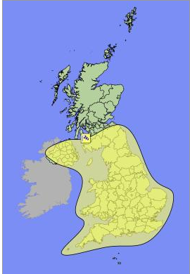
Much the same as Thursday.
Now as the OP has already said these are subject to change and most probably will as i have seen them change 3 times over the course of the day.
So keep checking to see warnings in effect in your area so you can be prepared and aware =)
Met Office
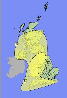
Monday 12/12/2011
Showing weather warnings for heavy rain across extreme southern and western England and Wales. Beware of flooding in high risk areas.
Tuesday 13/12/2011
Showing much the same as Monday except with the addition snow warnings for Northern Ireland, Scotland and Northern England
Wednesday 14/12/2011
Same as Tuesday but without the Rain warnings.
Thursday 15/12/2011
This is where it gets interesting, this is a warning in place of winds for the entire of England, Wales, Northern Ireland and parts of Scotland and has been revised down from covering the entire UK. Hopefully Scotland can escape the brunt of this one.
Friday 16/12/2011
Much the same as Thursday.
Now as the OP has already said these are subject to change and most probably will as i have seen them change 3 times over the course of the day.
So keep checking to see warnings in effect in your area so you can be prepared and aware =)
Met Office
Originally posted by Flavian
Originally posted by spacedonk
I spoke to a business colleague in Scotland this morning and he tells me the media are predicting a storm of 'thundersnow' on Friday, excepting that this sounds like the name of some dodgy manga character, it is reported this storm will hit on Friday and consist of thunder, lightening, hail and snow.
Genius! What is the special power then?
Seriously though, what the **** is 'thundersnow'? I have genuinely never heard of that before!
Thundersnow is Lightning when its snowing. In the UK its not all that common and conditions need to be quite unique for it, however, last year i experienced it twice within that "cold snap". We had, at the time, a NE wind that brought moisture over the relatively warm North Sea. This produced convection in the unstable atmosphere that allowed cumulonimbus clouds to grow. Of course blown in on the NE wind, we got the snow (which was mainly hail at the time of lightning) and the lightning.
Think of it as a bad down pour in summer, except its in winter...thats the easiest way to describe it...instead of heavy rain, its heavy snow...
Oh and it can be quite spectacular because of the flash and the falling snow! Thunder can be difficult to hear and lightning hard to see though if the strike is far away because of the snow fall so it can "come out of the blue".
I haven't read up on the Thundersnow reports yet but i had my suspicions about it occurring which is why i posted the Cape Values chart in the beginning and the Thunderstorm Advisory above.
edit on 12/12/11 by jrmcleod because: (no reason given)
Originally posted by RumET
Good afternoon Jamie,thank you for the long and great update. Now I've always wished to ask you, what is that long and thick black line in the GFS pressure chart? Is it the line separating the highs and lows, or maybe something else. I'm sure I know it, when you reply, but I just forgot right now. Thanks again.
Considering a person earlier up not wishing to sink to my level. I am sorry, I couldn't possibly know what Bawbag meant before my UK friend explained it to me today. So no offense, I am Russian after all. We don't give rude nicknames to our storms. And it did sound a little like "Blowbag" I dare not to think what that word means.edit on 12/12/2011 by RumET because: Added a sincere apology.
The black line is the 552 Dam Line of the 500hpa surface (height roughly 18,000ft). Its a guided midpoint value that helps trace any major troughs and/or ridges in the viewed/current weather pattern.
A dam line is basically the height that you would have to go up to before the pressure falls to 500hPa.
From a typical 500hPa chart, the best way to work out the 1000-500 thickness is:
(1000-SLP) + 500hPa height
...where: SLP - Sea Level Pressure
And the 500hPa height can be found by using the scale on the right hand side of the chart.
edit on 12/12/11 by jrmcleod because: (no reason given)
Here's another interesting Weather graphic that may help in getting a clerarer picture as to what to expect where and when.
I notice a ridge of high pressure to the North though in this forecast having sneeked in behind our upcoming Storm for Tuesday, seemingly affecting the severity (not looking as threatening) for Fridays Storm as this one is blocked and tracks through Southern England.
www.meteox.com...
No sign of this High anticipated to form yet in the Met office Graph though.
reply to post by moosevernel
Thanks moosevernel.
I think this is a case of the Met Office don't really know whats in store for Friday yet (nor does anyone really). Until the models come into some kind of agreement, it will remain sketchy until Wednesday/Thursday no doubt. Where as tomorrow you can almost certainly bet that the Met Office have called it correct for the worst affected area
edit on 12/12/11 by jrmcleod because: (no reason given)
reply to post by jrmcleod
I came to that conclusion myself as you say its a case of wait and see. Hope it turns out to be less severe than expected and i appreciate all the hard work you have put in to this thread helping people to be aware and prepared =)
I came to that conclusion myself as you say its a case of wait and see. Hope it turns out to be less severe than expected and i appreciate all the hard work you have put in to this thread helping people to be aware and prepared =)
Originally posted by Flavian
Originally posted by spacedonk
I spoke to a business colleague in Scotland this morning and he tells me the media are predicting a storm of 'thundersnow' on Friday, excepting that this sounds like the name of some dodgy manga character, it is reported this storm will hit on Friday and consist of thunder, lightening, hail and snow.
Genius! What is the special power then?
Seriously though, what the **** is 'thundersnow'? I have genuinely never heard of that before!
I have seen it a few times in the South East of England in winter storms over the years, white out conditions & blizzards normally follow,
I was driving home from work when we come up to a wall of cloud jumping of the M1 onto the A5, we see a few lightening strikes and thought WTF?, then we hit a wall of snow in white out conditions, it took us 4 hours to travel 20 odd miles and by then there was a good 8ins on the ground,
Back on topic
What on earth is going on nearly all the isobar/pressure charts for Thursday & Friday are totally different? and they seem to be changing often, is this normal or is this thurs/fri storm just so hard to predict ?
Seem Thursday Fridays has flopped acording to this chart
And the met has it totally different
www.metoffice.gov.uk...
edit on 12-12-2011 by BRITWARRIOR because: (no reason given)
reply to post by BRITWARRIOR
There is differences between the models on the prediction of this storm. For example, the ECM had it at 920mb's a few days ago then suddenly changed its mind at basically it vanished. GFS has played around with it a bit and down graded it slightly.
This is believe is why earlier there was the "blanket" warning for the whole UK, the models just couldnt agree on it. Until you have alignment from the models, a forecast becomes a bit of hit and miss. We will see when the next release of model data becomes available later this evening.
This is exactly why, even at 4 days forecasting becomes very difficult, even with the use of super computers around the world.
But to answer your question, yes it can be normal and in this circumstance. The computers rely on so many variables...there can be differing model outputs
reply to post by jrmcleod
Aye, get this week out of the way, then a few cooler days with again a risk of some snow showers and then, just in time for Christmas it turns all mild again. GFS has been fairly consistent over the past few runs. Could be double figure maximums - a far cry from the -4.4c max I had on the 25th last year!
Aye, get this week out of the way, then a few cooler days with again a risk of some snow showers and then, just in time for Christmas it turns all mild again. GFS has been fairly consistent over the past few runs. Could be double figure maximums - a far cry from the -4.4c max I had on the 25th last year!
Don't think I have ever seen such a big disagreement in the charts at only 24 hrs out. The GFS and the GME are giving me two entirely different types
of day up here on the NW Ireland coast. One has it slightly breezy, the other storm force 10. Still playing a waiting game with less than 24hrs to go.
Would hate to be a weather forecaster on this one.
Oh and the thurs/fri storm showed signs of reappearing early this morning but has since died away yet again.
Oh and the thurs/fri storm showed signs of reappearing early this morning but has since died away yet again.
Originally posted by Essan
reply to post by jrmcleod
Aye, get this week out of the way, then a few cooler days with again a risk of some snow showers and then, just in time for Christmas it turns all mild again. GFS has been fairly consistent over the past few runs. Could be double figure maximums - a far cry from the -4.4c max I had on the 25th last year!
I know...i'm still hoping for a sudden change in the pattern. Unlikely but we can still pray! Even just for the 25th!!!
reply to post by jrmcleod
Ok thank you for clearing that up, so basically Thurs/Friday could still be on? i take it the Mon/Tues model is now pretty certain to play out like predicted in the models?
I will be keeping an eye on the models and also looking forward to your updates this evening,
Ok thank you for clearing that up, so basically Thurs/Friday could still be on? i take it the Mon/Tues model is now pretty certain to play out like predicted in the models?
I will be keeping an eye on the models and also looking forward to your updates this evening,
From what I can see with GRIB, the whole thing needs downgrading. Windy - yes, but unless things change, not as bad as first thought
Originally posted by moosevernel
.
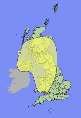
Thursday 15/12/2011
This is where it gets interesting, this is a warning in place of winds for the entire of England, Wales, Northern Ireland and parts of Scotland and has been revised down from covering the entire UK. Hopefully Scotland can escape the brunt of this one.
Friday 16/12/2011
Much the same as Thursday.
Now as the OP has already said these are subject to change and most probably will as i have seen them change 3 times over the course of the day.
So keep checking to see warnings in effect in your area so you can be prepared and aware =)
Met Office
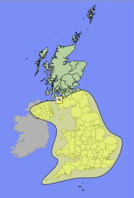
It looks like the met office has listened to our most vociferous Scottish posters on here and decided the Scots are so tough that they don't need warnings about a bit of weather
I want Thundersnow, if we had a storm of that I'd put a gas heater in the summerhouse and sit out watching it with large steaming mugs of black coffee laced with brandy
I don't know if anybody caught the model last night but Friday was back on track as predicted the week before if not slightly downgraded, now it
seems it will be a none event, i'm kind of new to this, so slightly confusing at the minute for me but nether the less great for doing some
learnings, always been fascinated with the weather, all types, i usually turn amature every summer during the summer, tracking thunderstorms & snow in
the winter,
I do remember the 1987 storm very well as it took me and my brothers of our feet on the way home from school a few times, does anyone have a chart for that day or now the LP ? i sure some of you do
I do remember the 1987 storm very well as it took me and my brothers of our feet on the way home from school a few times, does anyone have a chart for that day or now the LP ? i sure some of you do
reply to post by yellowbeard
haha you could be right there...i personally think the met office have been following the OP's thread and updating thier website from here
haha you could be right there...i personally think the met office have been following the OP's thread and updating thier website from here
new topics
-
WF Killer Patents & Secret Science Vol. 1 | Free Energy & Anti-Gravity Cover-Ups
General Conspiracies: 12 minutes ago -
Hurt my hip; should I go see a Doctor
General Chit Chat: 1 hours ago -
Israel attacking Iran again.
Middle East Issues: 2 hours ago -
Michigan school district cancels lesson on gender identity and pronouns after backlash
Education and Media: 2 hours ago -
When an Angel gets his or her wings
Religion, Faith, And Theology: 3 hours ago -
Comparing the theology of Paul and Hebrews
Religion, Faith, And Theology: 3 hours ago -
Pentagon acknowledges secret UFO project, the Kona Blue program | Vargas Reports
Aliens and UFOs: 4 hours ago -
Boston Dynamics say Farewell to Atlas
Science & Technology: 5 hours ago -
I hate dreaming
Rant: 5 hours ago -
Man sets himself on fire outside Donald Trump trial
Mainstream News: 7 hours ago
top topics
-
The Democrats Take Control the House - Look what happened while you were sleeping
US Political Madness: 8 hours ago, 18 flags -
In an Historic First, In N Out Burger Permanently Closes a Location
Mainstream News: 10 hours ago, 16 flags -
A man of the people
Medical Issues & Conspiracies: 15 hours ago, 11 flags -
Biden says little kids flip him the bird all the time.
Politicians & People: 7 hours ago, 8 flags -
Man sets himself on fire outside Donald Trump trial
Mainstream News: 7 hours ago, 7 flags -
Pentagon acknowledges secret UFO project, the Kona Blue program | Vargas Reports
Aliens and UFOs: 4 hours ago, 6 flags -
Israel attacking Iran again.
Middle East Issues: 2 hours ago, 5 flags -
Michigan school district cancels lesson on gender identity and pronouns after backlash
Education and Media: 2 hours ago, 4 flags -
4 plans of US elites to defeat Russia
New World Order: 17 hours ago, 4 flags -
Boston Dynamics say Farewell to Atlas
Science & Technology: 5 hours ago, 4 flags
active topics
-
WF Killer Patents & Secret Science Vol. 1 | Free Energy & Anti-Gravity Cover-Ups
General Conspiracies • 1 • : WakeofPoseidon -
Hurt my hip; should I go see a Doctor
General Chit Chat • 8 • : Dandandat3 -
The Democrats Take Control the House - Look what happened while you were sleeping
US Political Madness • 67 • : WeMustCare -
Israel attacking Iran again.
Middle East Issues • 21 • : KrustyKrab -
Thousands Of Young Ukrainian Men Trying To Flee The Country To Avoid Conscription And The War
Other Current Events • 53 • : ghandalf -
Boston Dynamics say Farewell to Atlas
Science & Technology • 5 • : Caver78 -
Biden says little kids flip him the bird all the time.
Politicians & People • 16 • : stelth2 -
When an Angel gets his or her wings
Religion, Faith, And Theology • 2 • : stelth2 -
MULTIPLE SKYMASTER MESSAGES GOING OUT
World War Three • 51 • : Zaphod58 -
Pentagon acknowledges secret UFO project, the Kona Blue program | Vargas Reports
Aliens and UFOs • 7 • : Ophiuchus1