It looks like you're using an Ad Blocker.
Please white-list or disable AboveTopSecret.com in your ad-blocking tool.
Thank you.
Some features of ATS will be disabled while you continue to use an ad-blocker.

Advanced Warning of Double Major Storms For UK Next Week - In Depth Analysis (Be Prepared)
page: 1share:
As some of you will know, i recently composed a thread here regarding the storm that
struck the UK earlier this week. With 165mph gusts at height and 114mph at lower levels and over £150 million worth of damage, the thought of a
second storm in as many days, let alone a third is frightening. However, that is indeed the case, and this time not one part of the UK will escape.
Let me explain.
On Tuesday, a severe extratropical cyclone will hit Scotland and the North of England. This storm will be comparative to the one experienced this week and will bring further havoc to an already battered country. With the lead up to Christmas, its the last thing anyone wants. Its a time to be prepared, none of us want our Christmas ruined by damaged homes, lives and possessions.
The story doesnt end there though. Once this storm passes through after about 24hours, a second even stronger storm will hit the south of England on Friday 16th December. This storm will affect the most densly populated area of Europe and could pose a significant risk to life through wind and flooding, This second storm will be the equivenlent to a CATAGORY 3 hurricane.
This second storm will have a probable central pressure of arounf 945mb, this is exceptionally deep and only around 15mb off of the UK record set in 1884.
Do not ignore this as a simple windy winters day, or a usual storm, because it most certainly isn't. This second storm will go down in history, and the damage total will be far higher than the £150 million in Scotland this week.
Ok so without further ado, let me provide some more detail on the nitty gritty. (Please bear in mind that i will be updating this thread as the weekend and week progress).
Tuesday 13th December
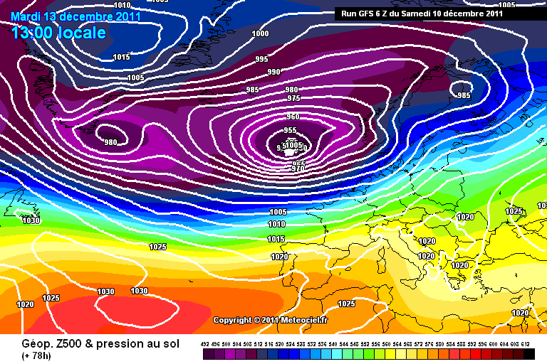
This image shows you the model prediction for the storm on Tuesday 13th December. As you can see, the most visible pressure is 955mb, however, inside that are other lines, so the pressure will be nearer the 950mb mark. Slightly more powerful than the storm experience this week. It will roughly follow the same line as this weeks storms and the affected areas will largely be the same.
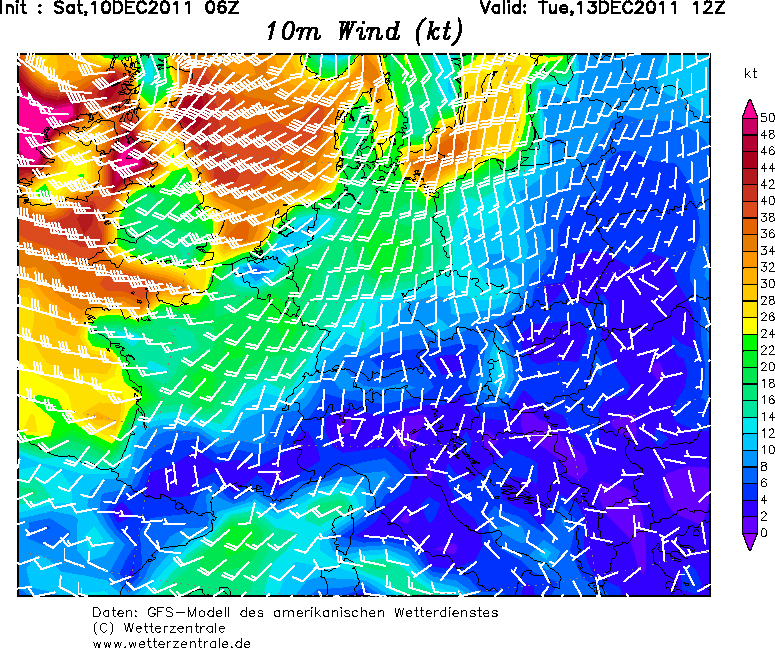
As you can see in this image, we are looking at areas achieving sustained winds greater than 50knts. This isn't gusts of wind, this is sustained. 50 knots is equal to around 60mph sustained. The chart above only goes upto 50knts so its difficult to tell with this chart.
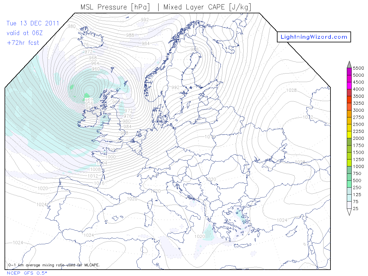
This chart shows you the energy of the storm system in terms of cape and the respective pressures. This is the energy required to produce thunderstorms. As you can see there is potential for thunderstorms, which also bring an added danger of sporadic tornados, as witnessed in Scotland this week.
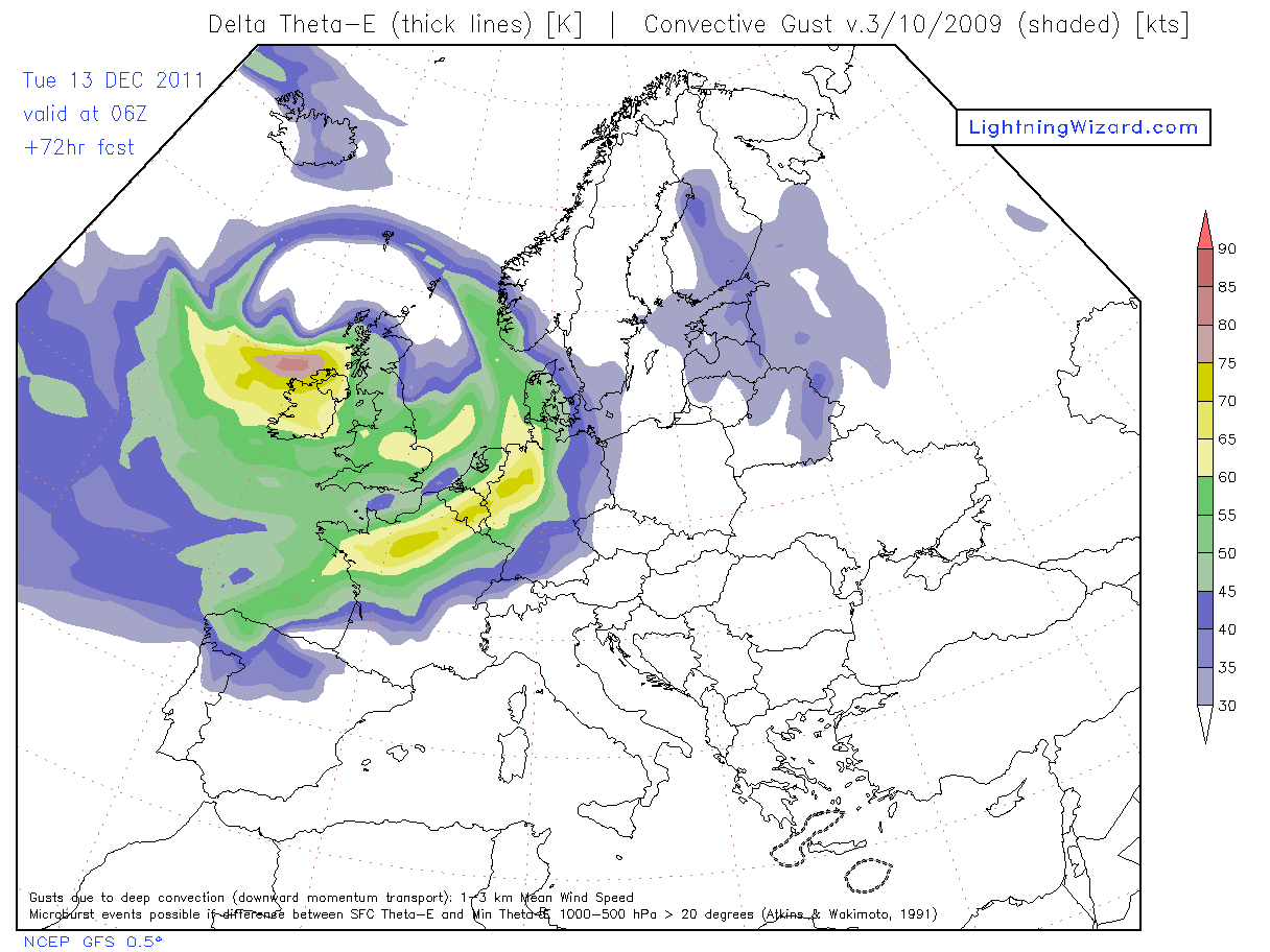
This chart is showing you the sporadic gust speeds in knots. As you can see, the west looks like they will have gusts exceeding 90knots which is over 100mph. Again, very similar to this weeks storm.
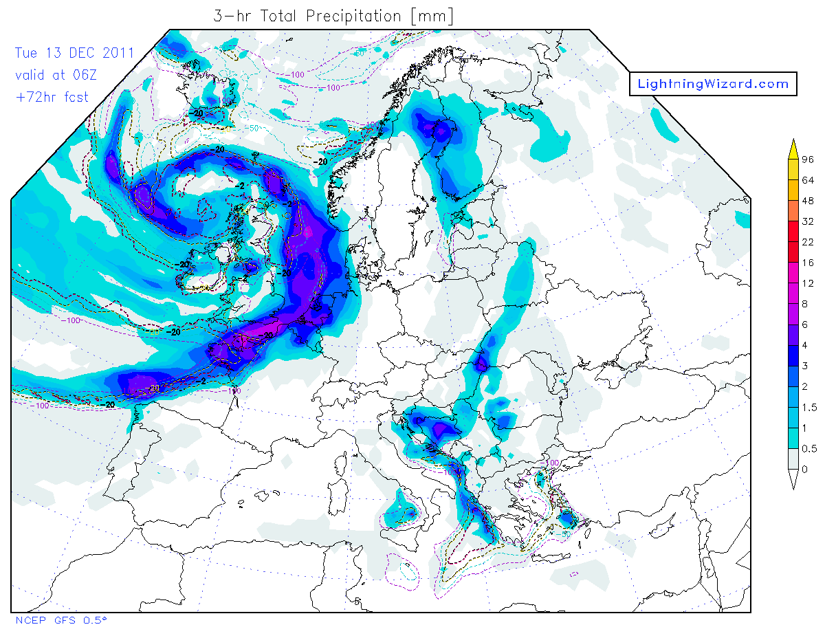
This image is showing the volume of precipitaion in any 3 hour time span during the storm, so not only do we have winds to contend with, we also have a lot of rain/sleet/snow which could lead to flooding as the ground is already saturated.
At present the only MetO warning that is in place is for the SW of England on Monday. Please monitor their site for updates that will occur over the coming days, and dont be surprised is there are Red Alerts issued.
Friday 16th December
Details for this storm at present are harder to predict but what i will say is that if this storm pulls off, and it looks like it will, this will be a storm that will be remembered for many years. This storm, if it verifies, will be the equivelant to a Category 3 Hurricane. This storm will most likely track through the English Channel and will affect not only most of the UK, but also Holland and the other low countries in Europe. the winds associated with this storm could be in excess of 130mph. This is sustained gusts over a 1 minute period. This will pull down trees, rip off roofs, windows in high rise flats blown in, fences taken down, power cuts lasting up to a week, most caravans destroyed if in the dirct wind. To give you an idea, Hurricane Ivan was a category 3 Hurricane.
This LINK will provide some further detail on what damage can be expected if this storm on the 16th verifys.
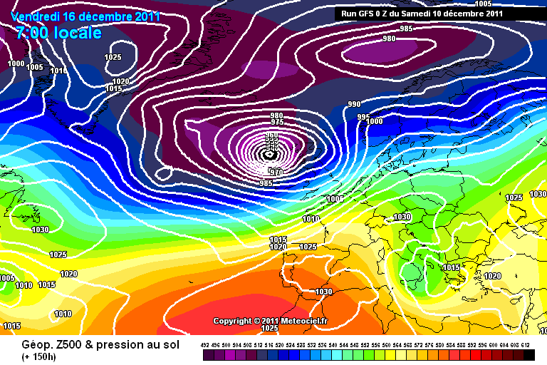
Storm on Friday 16th December with exceptionally low central pressure.
Please don't underestimate the power of these 2 up and coming storms. This is NOT fear mongering, this is a delivery of information to allow you to prepare your homes and families for storms that will take place this week.
I will be providing further updates on these storms over the weekend and next week as they approach. As time passes by, we can get a clearer view of whats in store with finer details.
Please remember that this information is subject to change, as the areas to be worst affected may change over the next 3 days. Any changes projected will be detailed by myself throughout the thread so please follow if you wish to know more information.
On Tuesday, a severe extratropical cyclone will hit Scotland and the North of England. This storm will be comparative to the one experienced this week and will bring further havoc to an already battered country. With the lead up to Christmas, its the last thing anyone wants. Its a time to be prepared, none of us want our Christmas ruined by damaged homes, lives and possessions.
The story doesnt end there though. Once this storm passes through after about 24hours, a second even stronger storm will hit the south of England on Friday 16th December. This storm will affect the most densly populated area of Europe and could pose a significant risk to life through wind and flooding, This second storm will be the equivenlent to a CATAGORY 3 hurricane.
This second storm will have a probable central pressure of arounf 945mb, this is exceptionally deep and only around 15mb off of the UK record set in 1884.
Do not ignore this as a simple windy winters day, or a usual storm, because it most certainly isn't. This second storm will go down in history, and the damage total will be far higher than the £150 million in Scotland this week.
Ok so without further ado, let me provide some more detail on the nitty gritty. (Please bear in mind that i will be updating this thread as the weekend and week progress).
Tuesday 13th December
This image shows you the model prediction for the storm on Tuesday 13th December. As you can see, the most visible pressure is 955mb, however, inside that are other lines, so the pressure will be nearer the 950mb mark. Slightly more powerful than the storm experience this week. It will roughly follow the same line as this weeks storms and the affected areas will largely be the same.
As you can see in this image, we are looking at areas achieving sustained winds greater than 50knts. This isn't gusts of wind, this is sustained. 50 knots is equal to around 60mph sustained. The chart above only goes upto 50knts so its difficult to tell with this chart.
This chart shows you the energy of the storm system in terms of cape and the respective pressures. This is the energy required to produce thunderstorms. As you can see there is potential for thunderstorms, which also bring an added danger of sporadic tornados, as witnessed in Scotland this week.
This chart is showing you the sporadic gust speeds in knots. As you can see, the west looks like they will have gusts exceeding 90knots which is over 100mph. Again, very similar to this weeks storm.
This image is showing the volume of precipitaion in any 3 hour time span during the storm, so not only do we have winds to contend with, we also have a lot of rain/sleet/snow which could lead to flooding as the ground is already saturated.
At present the only MetO warning that is in place is for the SW of England on Monday. Please monitor their site for updates that will occur over the coming days, and dont be surprised is there are Red Alerts issued.
Friday 16th December
Details for this storm at present are harder to predict but what i will say is that if this storm pulls off, and it looks like it will, this will be a storm that will be remembered for many years. This storm, if it verifies, will be the equivelant to a Category 3 Hurricane. This storm will most likely track through the English Channel and will affect not only most of the UK, but also Holland and the other low countries in Europe. the winds associated with this storm could be in excess of 130mph. This is sustained gusts over a 1 minute period. This will pull down trees, rip off roofs, windows in high rise flats blown in, fences taken down, power cuts lasting up to a week, most caravans destroyed if in the dirct wind. To give you an idea, Hurricane Ivan was a category 3 Hurricane.
This LINK will provide some further detail on what damage can be expected if this storm on the 16th verifys.
Storm on Friday 16th December with exceptionally low central pressure.
Please don't underestimate the power of these 2 up and coming storms. This is NOT fear mongering, this is a delivery of information to allow you to prepare your homes and families for storms that will take place this week.
I will be providing further updates on these storms over the weekend and next week as they approach. As time passes by, we can get a clearer view of whats in store with finer details.
Please remember that this information is subject to change, as the areas to be worst affected may change over the next 3 days. Any changes projected will be detailed by myself throughout the thread so please follow if you wish to know more information.
edit on 10/12/11 by jrmcleod because:
(no reason given)
edit on 10/12/11 by jrmcleod because: (no reason given)
I wouldn't worry too much. It is Winter afterall
Besides which I have seen far worse stroms than the ones we have had over the last few years. Not only that but we also have more analytical technology to salivate over the facts and figures and of course the hightened awareness of mind nowadays.. it all adds to the intensity but its just cold wind, natural for this time of year..
Just wrap up warm and heat up that bottle of mulled wine
Subscribed, flaged and starred!
Thank you for all your hard work on the last thread and I am sure this one will be no different......except bigger by your update so far!
Batton down the hatches me hearties...this is gonna get rough!
Thanks again Mr Mcleod....or can we call you Jamie now?
Rainbows
Jane
Thank you for all your hard work on the last thread and I am sure this one will be no different......except bigger by your update so far!
Batton down the hatches me hearties...this is gonna get rough!
Thanks again Mr Mcleod....or can we call you Jamie now?
Rainbows
Jane
Thanks again for the heads up.
Good call on the last one too.
Good call on the last one too.
reply to post by jrmcleod
Thanks for keeping us informed. It's certainly not fear mongering, being prepared and aware is always a good thing.
If the storm on the 16th is on a level, or even worse than 'Hurricane Bawbag' then it's great that you can give people a head start on planning their week so they can avoid the worst of it. The met office will probably be advising us to do the same.....just with less notice !
(Edit to add, the met office have just added a yellow warning for Tuesday, I'm beginning to think they use Jrmcleod's threads to predict the weather )
edit on 10-12-2011 by DrHammondStoat because: (no reason given)
Fantastic work, you have always been spot on..
I wish I could add more stars and flags..
have been warning all the oldies around here to get their stocks up and be prepared..
thanks again, brilliant
I wish I could add more stars and flags..
have been warning all the oldies around here to get their stocks up and be prepared..
thanks again, brilliant
reply to post by jrmcleod
A most excellent thread weather dude, flagged. Thanks for thr heads up!
Mind you, the scot highlanders are a very hardy bunch, they can take it.
We need decent weather news like this on mainstream to ensure that people are given more of a kick up the pants to get them to prepare over a longer period. Maybe, if those elderly had more time to really prepare there wouldnt be so many fatalities from this government/corporate modified weather.
Thanking you.
Originally posted by Oxygenation
I wouldn't worry too much. It is Winter afterall
Besides which I have seen far worse stroms than the ones we have had over the last few years. Not only that but we also have more analytical technology to salivate over the facts and figures and of course the hightened awareness of mind nowadays.. it all adds to the intensity but its just cold wind, natural for this time of year..
Just wrap up warm and heat up that bottle of mulled wine
This is precisely why i have posted this thread. This is NOT the same and i doubt very much you will have seen a storm as bad as the potential storm for Friday 16th December.
If the storm projections fall true for Friday 16th December, it will put the Great storm of 1987 and the Burns Day Storm of 1990 to shame, which were the worst since 1703. The lowest pressure of the Great storm was 953mb and the higest winds recorded were 134mph. This Fridays storm is projected to have a central pressure lower by 8mb, which will most likely mean the wind will be stronger than 130mph (gusts).
This is comparable to a category 3 Hurricane..i can't emphasise that enough!
Originally posted by TheMindWar
reply to post by jrmcleod
A most excellent thread weather dude, flagged. Thanks for thr heads up!
Mind you, the scot highlanders are a very hardy bunch, they can take it.
We need decent weather news like this on mainstream to ensure that people are given more of a kick up the pants to get them to prepare over a longer period. Maybe, if those elderly had more time to really prepare there wouldnt be so many fatalities from this government/corporate modified weather.
Thanking you.
There is no doubt that the Scottish have endured similar storms more frequently, but the storm on the 16th is forecast to be worst in southern England. Those of you who remember 1987...it mighht be a bit of Deja Vu come Friday.
I pray it all crumbles to pieces and doesnt come to fruition...i really do!
Originally posted by angelchemuel
Subscribed, flaged and starred!
Thank you for all your hard work on the last thread and I am sure this one will be no different......except bigger by your update so far!
Batton down the hatches me hearties...this is gonna get rough!
Thanks again Mr Mcleod....or can we call you Jamie now?
Rainbows
Jane
Jamie is fine with me. Yes i'm sure this thread will be bigger, i'm also sure other threads will apper before and in the wake of the storm!
reply to post by jrmcleod
Great thread. For up to date weather direct from the NOAA and global models, register on the site www.grib.us its free, download their software and draw a square over Europe. Quite eye opening as to whats going on.
The software is a simple GRIB file download facility and viewer, gives forecast for 5 - 7 days based upon the most up to date computer models publicly available. There's usually a new model every 3 hours, if you download a file within the software once every three hours you ought to see a change.
No I would not worry too much.
Compared to Hurricane Bawbag as we called it in Scotland. It will be a drop in the Ocean.
Everyone enjoyed the day off or were happy to go home early.
Lets hope this happens again next Tuesday.
Downside they are saying it cost the Scottish Economy £100 Million in just one day.
Compared to Hurricane Bawbag as we called it in Scotland. It will be a drop in the Ocean.
Everyone enjoyed the day off or were happy to go home early.
Lets hope this happens again next Tuesday.
Downside they are saying it cost the Scottish Economy £100 Million in just one day.
Excellent. Thank you for the advance warning on this thread and the previous.
I currently have travel plans on the 16th that I will try and re-schedue. Sounds like the motorways won't be safe on the 16th.
Valuable information. S+F.
I currently have travel plans on the 16th that I will try and re-schedue. Sounds like the motorways won't be safe on the 16th.
Valuable information. S+F.
Originally posted by jrmcleod
Originally posted by Oxygenation
I wouldn't worry too much. It is Winter afterall
Besides which I have seen far worse stroms than the ones we have had over the last few years. Not only that but we also have more analytical technology to salivate over the facts and figures and of course the hightened awareness of mind nowadays.. it all adds to the intensity but its just cold wind, natural for this time of year..
Just wrap up warm and heat up that bottle of mulled wine
This is precisely why i have posted this thread. This is NOT the same and i doubt very much you will have seen a storm as bad as the potential storm for Friday 16th December.
If the storm projections fall true for Friday 16th December, it will put the Great storm of 1987 and the Burns Day Storm of 1990 to shame, which were the worst since 1703. The lowest pressure of the Great storm was 953mb and the higest winds recorded were 134mph. This Fridays storm is projected to have a central pressure lower by 8mb, which will most likely mean the wind will be stronger than 130mph (gusts).
This is comparable to a category 3 Hurricane..i can't emphasise that enough!
Still, it's just wind mate. So it knocks a few tiles of your rooftop, downs a few trees, shakes a few buildings..it's nothing to fear or worry about in my book.. each to their own though
reply to post by Oxygenation
It just did not knock tiles off roofs, nor did it only blow down trees.
What was amusing.
Those wind turbines everyone is stating are the best in the world. Could not cope with the wind. One Burst into flames while the other two blew over.
It just did not knock tiles off roofs, nor did it only blow down trees.
What was amusing.
Those wind turbines everyone is stating are the best in the world. Could not cope with the wind. One Burst into flames while the other two blew over.
reply to post by Oxygenation
It's more than a little bit of wind as you put it. The model I just looked at indicates 60knots could reach the UK south coast by next Friday. Also this storm is developing mid Atlantic the swell and fetch is likely to be phenomenal. Surfs up to say the least!
Some perspective-: (10 Knots = 11.5 MPH)
Beaufort Wind Scale
Windspeed
in MPH Description - Visible Condition
0 Calm smoke rises vertically
1 - 4 Light air direction of wind shown by smoke but not by wind vanes
4 - 7 Light breeze wind felt on face; leaves rustle; ordinary wind vane moved by wind
8 - 12 Gentle breeze leaves and small twigs in constant motion; wind extends light flag
13 - 18 Moderate breeze raises dust and loose paper; small branches are moved
19 - 24 Fresh breeze small trees in leaf begin to sway; crested wavelets form on inland water
25 - 31 Strong breeze large branches in motion; telephone wires whistle; umbrellas used with difficulty
32 - 38 Moderate gale whole trees in motion; inconvenience in walking against wind
39 - 46 Fresh gale breaks twigs off trees; generally impedes progress
47 - 54 Strong gale slight structural damage occurs; chimney pots and slates removed
55 - 63 Whole gale trees uprooted; considerable structural damage occurs
64 - 72 Storm very rarely experienced; accompanied by widespread damage
73+ Hurricane devastation occurs
Originally posted by Laurauk
No I would not worry too much.
Compared to Hurricane Bawbag as we called it in Scotland. It will be a drop in the Ocean.
Everyone enjoyed the day off or were happy to go home early.
Lets hope this happens again next Tuesday.
Downside they are saying it cost the Scottish Economy £100 Million in just one day.
These storms will be WORSE than Hurricane Bawbag. Please re-read the OP.
reply to post by Oxygenation
Well, I take it you wont be coming back here for updates then will you!
Rainbows
Jane
Well, I take it you wont be coming back here for updates then will you!
Rainbows
Jane
Originally posted by Laurauk
reply to post by Oxygenation
It just did not knock tiles off roofs, nor did it only blow down trees.
What was amusing.
Those wind turbines everyone is stating are the best in the world. Could not cope with the wind. One Burst into flames while the other two blew over.
When the wind is too powerful, wind turbines need to be shut down. The turbines were off because the wind was too strong, thats hy they were damaged.
reply to post by jrmcleod
Dude Scotland has been through worse before.
I will stick with what I said before. The Scots will cope, we always do.
And for the record the wind turbines were not turned off.
That is why it burst into flames in the first place it could not cope with the high winds.
Dude Scotland has been through worse before.
I will stick with what I said before. The Scots will cope, we always do.
And for the record the wind turbines were not turned off.
That is why it burst into flames in the first place it could not cope with the high winds.
edit on 10-12-2011 by Laurauk because: (no reason given)
new topics
-
Any one suspicious of fever promotions events, card only.
The Gray Area: 8 minutes ago -
God's Righteousness is Greater than Our Wrath
Religion, Faith, And Theology: 4 hours ago -
Electrical tricks for saving money
Education and Media: 7 hours ago -
VP's Secret Service agent brawls with other agents at Andrews
Mainstream News: 9 hours ago -
Sunak spinning the sickness figures
Other Current Events: 9 hours ago -
Nearly 70% Of Americans Want Talks To End War In Ukraine
Political Issues: 9 hours ago -
Late Night with the Devil - a really good unusual modern horror film.
Movies: 11 hours ago
top topics
-
VP's Secret Service agent brawls with other agents at Andrews
Mainstream News: 9 hours ago, 9 flags -
Cats Used as Live Bait to Train Ferocious Pitbulls in Illegal NYC Dogfighting
Social Issues and Civil Unrest: 13 hours ago, 8 flags -
Electrical tricks for saving money
Education and Media: 7 hours ago, 4 flags -
HORRIBLE !! Russian Soldier Drinking Own Urine To Survive In Battle
World War Three: 17 hours ago, 3 flags -
Sunak spinning the sickness figures
Other Current Events: 9 hours ago, 3 flags -
Nearly 70% Of Americans Want Talks To End War In Ukraine
Political Issues: 9 hours ago, 3 flags -
Late Night with the Devil - a really good unusual modern horror film.
Movies: 11 hours ago, 2 flags -
The Good News According to Jesus - Episode 1
Religion, Faith, And Theology: 15 hours ago, 1 flags -
God's Righteousness is Greater than Our Wrath
Religion, Faith, And Theology: 4 hours ago, 0 flags -
Any one suspicious of fever promotions events, card only.
The Gray Area: 8 minutes ago, 0 flags
active topics
-
SETI chief says US has no evidence for alien technology. 'And we never have'
Aliens and UFOs • 48 • : Consvoli -
Any one suspicious of fever promotions events, card only.
The Gray Area • 0 • : Cavemannick -
God's Righteousness is Greater than Our Wrath
Religion, Faith, And Theology • 1 • : andy06shake -
Sunak spinning the sickness figures
Other Current Events • 7 • : xWorldxGonexMadx -
HORRIBLE !! Russian Soldier Drinking Own Urine To Survive In Battle
World War Three • 33 • : Degradation33 -
How ageing is" immune deficiency"
Medical Issues & Conspiracies • 34 • : angelchemuel -
Nearly 70% Of Americans Want Talks To End War In Ukraine
Political Issues • 13 • : Freeborn -
Mood Music Part VI
Music • 3101 • : ThatSmellsStrange -
VP's Secret Service agent brawls with other agents at Andrews
Mainstream News • 41 • : ThatSmellsStrange -
New whistleblower Jason Sands speaks on Twitter Spaces last night.
Aliens and UFOs • 55 • : baablacksheep1