It looks like you're using an Ad Blocker.
Please white-list or disable AboveTopSecret.com in your ad-blocking tool.
Thank you.
Some features of ATS will be disabled while you continue to use an ad-blocker.

Why Is China Building These Gigantic Structures In the Middle of the Desert?
page: 4share:
reply to post by CaptainInstaban
Shizzle, sorry guys, im on google earth!! You can change the date on google earth!
My apologies!
Yeah i know what you are saying, i can see underneath some parts. But this would be possible if they were massive chalk lines, no?
Anyways if you have google earth check it out. Apologies again, my mistake!!
namaste x
I have saved what i was looking at on google earth, if someone can tell me how to add the image on here in a post i will happily post up for
ya's!!
I have no idea how to do it, when i click 'add image' at the top it just gives me space to add a link...
any help appreciated guys
x
I have no idea how to do it, when i click 'add image' at the top it just gives me space to add a link...
any help appreciated guys
x
reply to post by mazzle
I was already wondering if you were on GE intead of GM.
Do you have the pic uploaded on ATS?
Left click the pic, copy the url that´s under USE IN POST, copy the url into your post, don´t use the IMAGE function, just post the url, that should be it.
edit, your linky no worky for me.
I was already wondering if you were on GE intead of GM.
Do you have the pic uploaded on ATS?
Left click the pic, copy the url that´s under USE IN POST, copy the url into your post, don´t use the IMAGE function, just post the url, that should be it.
edit, your linky no worky for me.
edit on 14-11-2011 by CaptainInstaban because: (no reason given)
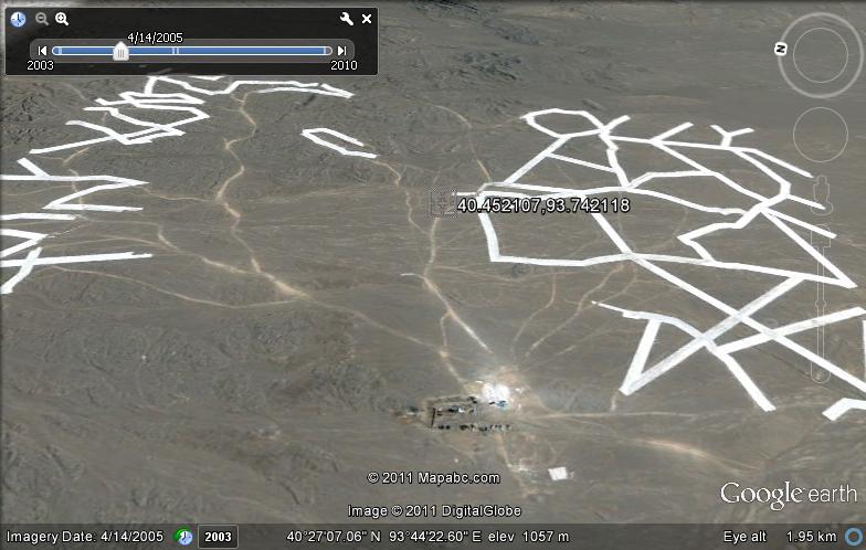
My money is on this area being an ULF radio antenna testbed. most of the patterns reminds me of antenna type constructions. The circular pattern
looks like an explosion/radiation test site, where sensors can be placed in varying positions in and out of cover to record temp, pressure, etc.
Even the suspicious aforementioned "nuke site" due west ~20 miles (look for the humongous square blue holding ponds...SIX MILES LONG!) has both the freakishly huge ponds, and miles of northward running canals (which terminate abruptly). Both features suggest much more than random make-work projects. My gut says they are working with ULF via water.
On a side note, explore the south end of the 'valley', where there are green spots with apparent water (pretty much due south of the rectangle). This region is hydrothermically active, and probably has been for centuries, judging by all the ancient ruins dotting the water sources.
And finally on the other side note, the rectangle is almost perfectly built to the golden ration (6000' x 3490' actual versus 6000'x3580' ratio) Hmmm.
edit on 14-11-2011 by blamethegreys because: (no reason given)
reply to post by CaptainInstaban
Those links arnt working are they?!
Sorry im new to ATS, i dont know how to upload a picture to ATS yet if you tell me how i will do it...unless the links are working for you and youve already seen the pics.
x
file:///C:/Documents%20and%20Settings/Advent/My%20Documents/white%20lines%202.jpg
Those links arnt working are they?!
Sorry im new to ATS, i dont know how to upload a picture to ATS yet if you tell me how i will do it...unless the links are working for you and youve already seen the pics.
x
file:///C:/Documents%20and%20Settings/Advent/My%20Documents/white%20lines%202.jpg
edit on 14-11-2011 by mazzle because: trying diff
method
When you zoom in on this position 44.261275,93.549442
You'll see that they are building some kind of massive windmill park.
If you scroll to the left from that position you'll see some unfinished ones or just under construction.
So I guess those lines are like some sort of powercables?
You'll see that they are building some kind of massive windmill park.
If you scroll to the left from that position you'll see some unfinished ones or just under construction.
So I guess those lines are like some sort of powercables?
reply to post by mazzle
Go to Tools, then ATS Uploads, click Select image file, pick your image, click open, the image now appears on your screen, left click the image, use the url under Use In Post, paste the url directly in your post.
Go to Tools, then ATS Uploads, click Select image file, pick your image, click open, the image now appears on your screen, left click the image, use the url under Use In Post, paste the url directly in your post.
edit on 14-11-2011 by CaptainInstaban because: (no reason given)
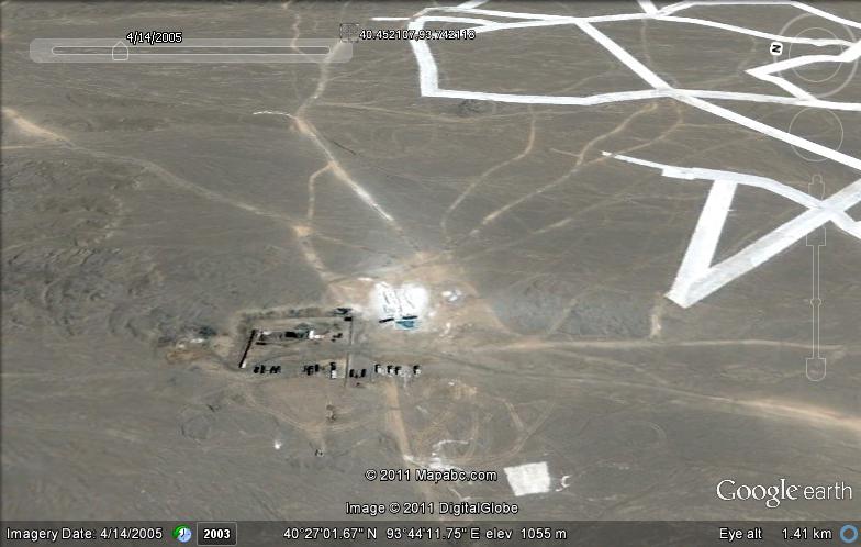
Folks! Come on now! Pay close attention to the fact that the zig zag pattern thing is actually UNDER THE TERRAIN! It is partially under ancient
erosion patterns, rivers, etc. One can clearly see this. The entire thing is huge and under hills, river beds, etc. They must be excavating an ancient
site. I say extraterrestrial. Millions...maybe even billions of years old.
maps.google.com...,93.393145&hl=en&ll=40.458018,93.392587&spn=0.0208,0.040426&sll=40.475028,90.849724&sspn=0.087881,0.161705&vp6& t=h&z=15
maps.google.com...,93.393145&hl=en&ll=40.458018,93.392587&spn=0.0208,0.040426&sll=40.475028,90.849724&sspn=0.087881,0.161705&vp6& t=h&z=15
edit on 14-11-2011 by FutureAbductee because: (no reason given)
edit on 14-11-2011 by FutureAbductee because: (no
reason given)
i can zoom in more if you like, now i know how to upload
thanks again!
reply to post by mazzle
Your welcome, it is indeed strange that the grid is not complete like in the original pic, but from this angle it only seems clearer that these white lines don´t physically exist, I mean look at them, I see CGI lines projected over the area.
Do you realize it´s not a matter of making a strip of an X amount of meters wide across those mountains in order for them to appear like straight lines from these angles? That would only be possible if they made corrections for one specific angle, but it is impossible for these lines to look this straight from all angles, while crossing these different heights, peaks and valleys.
With that amount of height difference the lines would appear all choppy, and not with these perfect corners.
edit, Yes I can see that they are doing something there, but still the lines seem like a projected roadplan to me.
edit on 14-11-2011 by
CaptainInstaban because: (no reason given)
edit on 14-11-2011 by CaptainInstaban because: (no reason given)
It's a targeting range for their new sub orbital laser systems , designed to bombard easrth surface targets from low earth orbit
I haven't read all the replies so this may have been mentioned. The first thing I thought of was the UFO that caused them to close an airport
earlier this year. Maybe something to do with that.
reply to post by LightAssassin
Yes I have, and if you look on Google Earth you will see they look nothing like these, cause they look like real lines in the ground, because they are real lines.
What are you saying?
Yes I have, and if you look on Google Earth you will see they look nothing like these, cause they look like real lines in the ground, because they are real lines.
What are you saying?
reply to post by CaptainInstaban
No, not those big white lines, I thought, in the comment I replied to, that you said the picture, that reminds me most of the Nazca lines, had grid lines that were too perfect?
I may have misread.
No, not those big white lines, I thought, in the comment I replied to, that you said the picture, that reminds me most of the Nazca lines, had grid lines that were too perfect?
I may have misread.
They are REAL! Look at my post a few post back for my explanation.
reply to post by LightAssassin
The third pic in the OP article might be the one you mean, it is also the only pic of the 5 pics that I think is legit, specifically because the grid lines are NOT perfect when you zoom in.
The third pic in the OP article might be the one you mean, it is also the only pic of the 5 pics that I think is legit, specifically because the grid lines are NOT perfect when you zoom in.
edit on 14-11-2011 by CaptainInstaban because: (no reason given)
new topics
-
Late Night with the Devil - a really good unusual modern horror film.
Movies: 1 hours ago -
Cats Used as Live Bait to Train Ferocious Pitbulls in Illegal NYC Dogfighting
Social Issues and Civil Unrest: 2 hours ago -
The Good News According to Jesus - Episode 1
Religion, Faith, And Theology: 4 hours ago -
HORRIBLE !! Russian Soldier Drinking Own Urine To Survive In Battle
World War Three: 6 hours ago -
Bobiverse
Fantasy & Science Fiction: 9 hours ago -
Florida man's trip overseas ends in shock over $143,000 T-Mobile phone bill
Social Issues and Civil Unrest: 9 hours ago -
Former Labour minister Frank Field dies aged 81
People: 11 hours ago
top topics
-
Florida man's trip overseas ends in shock over $143,000 T-Mobile phone bill
Social Issues and Civil Unrest: 9 hours ago, 8 flags -
SETI chief says US has no evidence for alien technology. 'And we never have'
Aliens and UFOs: 13 hours ago, 7 flags -
Cats Used as Live Bait to Train Ferocious Pitbulls in Illegal NYC Dogfighting
Social Issues and Civil Unrest: 2 hours ago, 7 flags -
This is our Story
General Entertainment: 16 hours ago, 4 flags -
Former Labour minister Frank Field dies aged 81
People: 11 hours ago, 4 flags -
Bobiverse
Fantasy & Science Fiction: 9 hours ago, 3 flags -
HORRIBLE !! Russian Soldier Drinking Own Urine To Survive In Battle
World War Three: 6 hours ago, 2 flags -
Late Night with the Devil - a really good unusual modern horror film.
Movies: 1 hours ago, 2 flags -
The Good News According to Jesus - Episode 1
Religion, Faith, And Theology: 4 hours ago, 0 flags
active topics
-
President BIDEN Vows to Make Americans Pay More Federal Taxes in 2025 - Political Suicide.
2024 Elections • 95 • : ImagoDei -
Cats Used as Live Bait to Train Ferocious Pitbulls in Illegal NYC Dogfighting
Social Issues and Civil Unrest • 8 • : lordcomac -
British TV Presenter Refuses To Use Guest's Preferred Pronouns
Education and Media • 140 • : Annee -
Florida man's trip overseas ends in shock over $143,000 T-Mobile phone bill
Social Issues and Civil Unrest • 16 • : grey580 -
HORRIBLE !! Russian Soldier Drinking Own Urine To Survive In Battle
World War Three • 22 • : RickyD -
SETI chief says US has no evidence for alien technology. 'And we never have'
Aliens and UFOs • 35 • : Consvoli -
Late Night with the Devil - a really good unusual modern horror film.
Movies • 1 • : DAVID64 -
Ditching physical money
History • 18 • : annonentity -
Lawsuit Seeks to ‘Ban the Jab’ in Florida
Diseases and Pandemics • 32 • : SchrodingersRat -
"We're All Hamas" Heard at Columbia University Protests
Social Issues and Civil Unrest • 279 • : KrustyKrab