It looks like you're using an Ad Blocker.
Please white-list or disable AboveTopSecret.com in your ad-blocking tool.
Thank you.
Some features of ATS will be disabled while you continue to use an ad-blocker.

Aircraft type ?
page: 11
share:
NOT going to make any claims of it being a UFO . Looks like a fighter jet , looking to just confirm or deny .
It is on Google Earth and here is the location 25°58'16.18"S 58° 1'37.03"W
Thanks for any input you able to give .
It is on Google Earth and here is the location 25°58'16.18"S 58° 1'37.03"W
Thanks for any input you able to give .
Dont know if its an aircraft, could it be clouds or some kind of deforestation, is it some kind of quarry? It does look like an F-18 or F-14
diving.
edit on 27-10-2011 by andy06shake because: (no reason given)
edit on 27-10-2011 by andy06shake because: (no reason
given)
Great catch, and good eyes! IMO it looks exactly like a fighter jet, although I do not know what kind. Hard to tell from that angle. I suppose there
is the possibility that it could be something on the ground...Such as a natural formation, or something along those lines.
Actually, looking at it I am convinced that it is an aircraft, and not something on the ground. I came to this conclusion by evaluating and scrutinizing the edges of the object in question, and imo the results point to a jet. The reason I do not believe it could be a cloud is that the rudders, the vertical fins, aren't consistent with a cloud.
Actually, looking at it I am convinced that it is an aircraft, and not something on the ground. I came to this conclusion by evaluating and scrutinizing the edges of the object in question, and imo the results point to a jet. The reason I do not believe it could be a cloud is that the rudders, the vertical fins, aren't consistent with a cloud.
edit on 10/27/11 by JiggyPotamus because: (no reason given)
Hard to tell is right , from the angle it appears it is in a dive . Damned fuzzy images
reply to post by watchdog8110
Are you referring to this....?
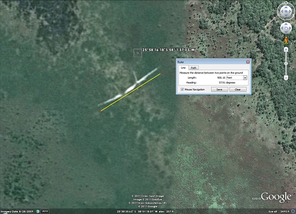
Whatever it is, it is over 900 ft wide and probably not an aircraft.
Are you referring to this....?
Whatever it is, it is over 900 ft wide and probably not an aircraft.
It's a road or track. The image is fuzzy, but in the air it is not.
Regards
Regards
Could be some kind of quarry, cant see any roads leading to it though? If its a aircraft i still think it a F18 or F14. The left of the screen in
google earth seems to be of a lower resolution than the right, could that influence it somehow?
edit on 27-10-2011 by andy06shake because: (no
reason given)
edit on 27-10-2011 by andy06shake because: (no reason given)
edit on 27-10-2011 by andy06shake because:
(no reason given)
Thanks guys , will put it under as to fuzzy to really determine it being a plane . Maybe GE will update that area in the future .
Originally posted by _Del_
Looks a bit like an exposed segment of pipeline to me.
I agree, seems plausible.
I was thinking maybe an old dam considering it seems to be in a gully where water once was, but there's a lack of permanent roads around it.
I wouldn't mind knowing what country this is in though.
Originally posted by Dimitri Dzengalshlevi
I wouldn't mind knowing what country this is in though.
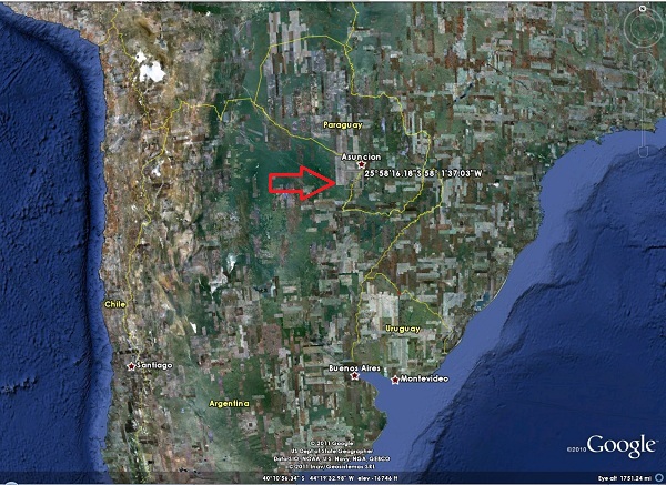
It is northern Argentina near the border of Paraguay...
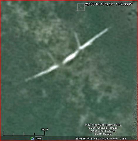
Does Argentina have maybe a suspension bridge across a valley? It kind of resembles that
Originally posted by waynos
Does Argentina have maybe a suspension bridge across a valley? It kind of resembles that
That was my very first thought, but it doesn't look like there are roads on either side. Paved roads would be pretty obvious to find in the trees.
EDIT: Unless it's a railroad bridge. Any closer, more defined images?
edit on 28-10-2011 by Dimitri Dzengalshlevi because: (no reason
given)
Originally posted by Dimitri Dzengalshlevi
That was my very first thought, but it doesn't look like there are roads on either side. Paved roads would be pretty obvious to find in the trees.
That's why I suspect it's a pipeline bridge. The pipeline simply goes back under ground after crossing the valley/wash.
That makes sense, another thing I've considered is that connecting roads my be lost in the vegetation due to the low res of the image, I've seen
that effect in google earth photos of areas local to me where I know the roads.
reply to post by andy06shake
The tail is all wrong for an F-18 and the F-14s are all in the boneyard. Ground markings.
The tail is all wrong for an F-18 and the F-14s are all in the boneyard. Ground markings.