It looks like you're using an Ad Blocker.
Please white-list or disable AboveTopSecret.com in your ad-blocking tool.
Thank you.
Some features of ATS will be disabled while you continue to use an ad-blocker.

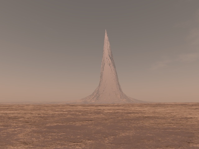
Huge Tower (5 Km high) in Hellas Planitia Region on Mars!
page: 10share:
Originally posted by BRITWARRIOR
Originally posted by Zatox
Most people getting hyped up thinking aliens did it, we have mountains on earth omg :O dont believe everything you see..edit on 20-10-2011 by Zatox because: (no reason given)
I think people concluding it is an alien structure are probably arriving at the more intelligent conclusion then you my friend, if you think that could ever be a mountain after understanding the data then, LOL more fool you
What about the youtube posters assumption that its a statue of a pharaoh with the head missing it's just a likley to be a statue of you brit.
Ps re this reply
Well, well... what an smug Ignorant turd you are my friend
your class shines through NOT!
edit on 21-10-2011 by wmd_2008 because: (no reason given)
edit on 21-10-2011 by wmd_2008 because: (no reason given)
reply to post by nenothtu
thanks for the information If I have time over the weekend I'll certainly check it out and see whats what.
Just out of curiosity , you mention that the MLOR would have send / returns from each particle . Wouldnt that make sifting throught the data for height maps incredibly time consuimg , even mars has dust storms so we would ideally be looking at flase data sets from the whole surface. Im sure the send/returns are designed only to bounce of solid matter of a certain mass , would make sense otherwise we'd have a huge margin of error .
Speaking of error , if the orbitor laser has returned false data on this one point then surely thats an error margin of 1% , and 1% for a full planent then we'd likely be seeing alot of these peaks all over the place.
It does beg for further investigation .
reply to post by sapien82
I don't know if we can "blame" the satellite for the wrong data, we have much more information about Earth (and in this case, California) but Google still shows things like this:
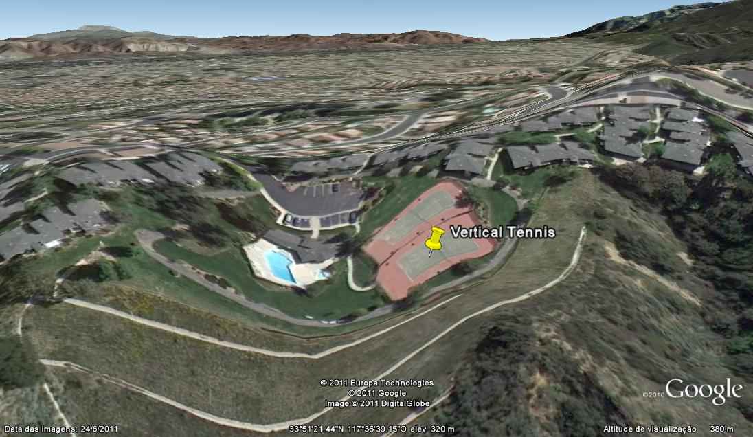
I don't know if we can "blame" the satellite for the wrong data, we have much more information about Earth (and in this case, California) but Google still shows things like this:
reply to post by ArMaP
Clearly, this is a timeline shift that has been caught on google earth.
Those tennis courts aren't where they're supposed to be...
Clearly, this is a timeline shift that has been caught on google earth.
Those tennis courts aren't where they're supposed to be...
reply to post by Chadwickus
Forget the tennis courts -- I want to know how that pool water stays tilted like that.
Forget the tennis courts -- I want to know how that pool water stays tilted like that.
Originally posted by Soylent Green Is People
reply to post by Chadwickus
Forget the tennis courts -- I want to know how that pool water stays tilted like that.
DOH its for water skiing what else!!!
Or the last bastion of a continent that was eroded away?
Just a thought.
Just a thought.
Originally posted by ArMaP
reply to post by sapien82
I don't know if we can "blame" the satellite for the wrong data, we have much more information about Earth (and in this case, California) but Google still shows things like this:
What, you mean you've never had to swim diagonally up a hill in your private pool?
Originally posted by sapien82
reply to post by nenothtu
you mention that the MLOR would have send / returns from each particle . Wouldnt that make sifting throught the data for height maps incredibly time consuimg , even mars has dust storms so we would ideally be looking at flase data sets from the whole surface. Im sure the send/returns are designed only to bounce of solid matter of a certain mass , would make sense otherwise we'd have a huge margin of error .
Not each particle, but the cloud of particles in the aggregate can send false returns. It's the same general idea that gave birth to radar chaff as a defense against radar - enough false returns, and the ground crew isn't sure which is real. Ideally, there will be multiple passes for each area, so that they can be compared against each other, and the false returns weeded out. For example, the SRTM data for the area I live in had 5 passes. MOLA I'm not sure about, but I believe some areas had significantly fewer orbital passes for the altimeter in order to have the redundant data to weed out false returns. In the case of Earth and the SRTM, polar areas got fewer passes, but in the case of Mars and MOLA, I'm not sure where the redundant data is lacking.
Speaking of error , if the orbitor laser has returned false data on this one point then surely thats an error margin of 1% , and 1% for a full planent then we'd likely be seeing alot of these peaks all over the place.
It does beg for further investigation .
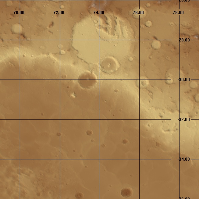
The terrain tile that spike shows up in is 90 degrees by 44 degrees. I haven't looked at all of it in small scale, but I did crop out a 10 by 10 degree square with the anomaly in the center, and there were no other spikes like that in that 100 square degrees (about 1.6 million data points). In most of that area, that single glitch sticks out like a sore thumb. The rest of it is relatively flat, not more than a few hundred meters variation, with gentler slopes, then you have that one single spike sticking up in the middle of a plain.
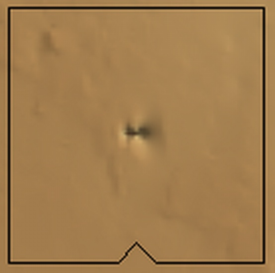
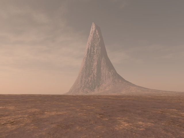
I'll post a few more pictures I made of it a little later - two in Terragen from 2m above the ground to simulate the views at man-height, and one that is an 8X enlargement of the anomaly from overhead which pretty clearly shows the we-like nature of the main part of it.
Originally posted by Chadwickus
reply to post by ArMaP
Clearly, this is a timeline shift that has been caught on google earth.
Those tennis courts aren't where they're supposed to be...
Not to mention the swimming pool - how do they keep that water in it on a slope like that?
Had a bit of trouble with the new upload portal, but I'm straight now. Here are the pictures:
1) The ten degree area with the anomaly in the center -
2) An 8X enlargement of the anomaly from directly over head. The horizontal black line between the hills is the web which forms the spike. Illumination is from the left -
3) Terragen (old version - 9.x - I was in a hurry and didn't feel like working out the textures for Mars in the new version) view of the anomaly from the south looking north. Notice how sharp the peaks are, and the fact that there is a slightly lower, but still ridiculously high, secondary anomalous data point to the right of the main peak which slopes upward to the main peak. (the slope of the sides appears to follow the function y = x^3) -
4) Terragen view from the west looking eastward. Notice the spike-like appearance, the sharp point, and the much thinner profile than in the other northward view. It only appears this wide because the web is hidden behind the "buttress" formed from the actual hill at the base having to slope upwards to the point because of the way the surface has to be deformed according to the data points (the slope of the sides here are very similar to the function that forms the slopes in the above view) -
edit on 2011/10/21 by nenothtu because: (no reason given)
Originally posted by nenothtu
Originally posted by CaptainInstaban
So is the data for the size and heiight of the cgi buildings obtained by programming the actual dimensions into the software, or is this directly derived from the satellite imagery?
In the case of the Google Earth 3D buildings, they are separate 3D models, most done in Google Sketchup, and imported into GE via KMZ files.
Thanks for the clarification.
Originally posted by Gorman91
reply to post by Arken
There's fook-ton worth of anomalies of legit concern, and you're worshiping this as some grand find, when it's clearly an error. how about the Mayan-like structures a few KM away?edit on 20-10-2011 by Gorman91 because: (no reason given)
What Mayan structures?
reply to post by nenothtu
Where are the pictures from??? Very nice...I used Terragen before nice little program, I use Bryce mostly.
Where are the pictures from??? Very nice...I used Terragen before nice little program, I use Bryce mostly.
reply to post by abeverage
I rendered the bottom two out in the last version of Terragen before they switched over to Terragen 2 - it's version 0.9.43 I think. I used that instead of the newer version with more under the hood because it already had preset shaders for the Martian surface and atmosphere, and I didn't feel like taking the time out to create martian shaders for the newer version.
The overhead map and the 8X closeup were done with 3dem, and I blew up the closeup to 8X using Irfanview.
Terragen, being a scenery renderer, adds detail that's not there in the original data. In this case the vertical striations on the anomaly itself. The rotation animations I did in 3dem showed the data more as it is, but I couldn't upload them since I have no YouTube account and didn't care to create one. As it rotates in those, you can see the knife-like character of the anomaly, and the fact that the sides are smoother on the "web" stretched out between the data points, rather than striated as the Terragen pictures appear.
I've tried to use Bryce, but it's beyond my ability. Not much in the way of description in the interface, so the various buttons are all guesswork to me. I never could hit the right combination of buttons to make an actual picture of anything at all in Bryce. The interface isn't set up for use by old timers like me, who just can't seem to suss out what the little picture of a palm tree is supposed to do to the render, then when I click one one or the other of the buttons, it presents me with options that may as well be written in an obscure South American Yanomami Indian dialect. maybe it was based on the Mac interface or something - I never got Macs figured out without someone hovering over my shoulder for a walkthrough, click by click, which is cumbersome...
I did some pictures In Terragen 2, which I may post a little later - they're on my laptop, and I'm on a desktop right now.
Edit to add: I cropped out the area from the original data file using 3dem (have to use the latitude/longitude display option rather than the sinusoidal in order to crop out the area), then converted it to a terragen .ter file for import to Terragen also using 3dem for the conversion.
3dem is a handy little program for working with nearly any sort of digital elevation models and converting them to the most often used formats. It imports USGS DEM files in either ASCII or SDTS formats, Mars MOLA, SRTM and GEOTIFF directly, and has an option to import any other data in columns and rows if you know the metadata for the file, exports USGS DEM, terragen .TER, GEOTIFF, and binary. If you have any sort of imagery, from satellite overheads to georeferenced maps, you can drape them right on to the surface produced for visualization of the data. If I had High resolution overhead images of this area, we could take a peek at what it looks like from the ground in a more or less "you are there" sort of view, or a "flyover". maybe MRO has some hi res of the area. I'll look into it later.
edit on 2011/10/24 by nenothtu because: (no reason given)
reply to post by abeverage
Look a bit around. There are quiet Mayan-looking pyramid shapes and placements of forms....assuming it was actually built.
Look a bit around. There are quiet Mayan-looking pyramid shapes and placements of forms....assuming it was actually built.
reply to post by abeverage
Yup, the overhead is MOLA. I looked around, and so far the closest I've found to high resolution photos has been in the data returned by the CTX camera, at 6m per pixel. I've been working on thos and re-doing the overhead map to give it a more realistic appearance instead of the laterally stretched appearance of the one I posted by converting it to a sinusoidal projection.
There were 3 CTX photo strips in that area, but only one of them approached the MOLA feature. That one cut it in half, but since half of it should show up on the photo, I've been identifying the area and searching for it on the photo, but no luck. I should have the images ready for a walk-through post in a bit.
Since the MOLA data are at 400 or 500 meters per pixel in that area, it should REALLY stand out at 6m per pixel if it's a real feature and not just a data artifact, and I'm not seeing it.
edit on 2011/10/24 by nenothtu because: (no reason given)
new topics
-
WF Killer Patents & Secret Science Vol. 1 | Free Energy & Anti-Gravity Cover-Ups
General Conspiracies: 44 minutes ago -
Hurt my hip; should I go see a Doctor
General Chit Chat: 1 hours ago -
Israel attacking Iran again.
Middle East Issues: 2 hours ago -
Michigan school district cancels lesson on gender identity and pronouns after backlash
Education and Media: 2 hours ago -
When an Angel gets his or her wings
Religion, Faith, And Theology: 3 hours ago -
Comparing the theology of Paul and Hebrews
Religion, Faith, And Theology: 4 hours ago -
Pentagon acknowledges secret UFO project, the Kona Blue program | Vargas Reports
Aliens and UFOs: 5 hours ago -
Boston Dynamics say Farewell to Atlas
Science & Technology: 5 hours ago -
I hate dreaming
Rant: 6 hours ago -
Man sets himself on fire outside Donald Trump trial
Mainstream News: 8 hours ago
top topics
-
The Democrats Take Control the House - Look what happened while you were sleeping
US Political Madness: 8 hours ago, 18 flags -
In an Historic First, In N Out Burger Permanently Closes a Location
Mainstream News: 10 hours ago, 16 flags -
A man of the people
Medical Issues & Conspiracies: 16 hours ago, 11 flags -
Biden says little kids flip him the bird all the time.
Politicians & People: 8 hours ago, 9 flags -
Man sets himself on fire outside Donald Trump trial
Mainstream News: 8 hours ago, 8 flags -
Pentagon acknowledges secret UFO project, the Kona Blue program | Vargas Reports
Aliens and UFOs: 5 hours ago, 6 flags -
Israel attacking Iran again.
Middle East Issues: 2 hours ago, 5 flags -
Michigan school district cancels lesson on gender identity and pronouns after backlash
Education and Media: 2 hours ago, 5 flags -
Boston Dynamics say Farewell to Atlas
Science & Technology: 5 hours ago, 4 flags -
Are you ready for the return of Jesus Christ? Have you been cleansed by His blood?
Religion, Faith, And Theology: 13 hours ago, 3 flags
active topics
-
When an Angel gets his or her wings
Religion, Faith, And Theology • 3 • : BrotherKinsMan -
Hurt my hip; should I go see a Doctor
General Chit Chat • 11 • : TheLieWeLive -
Sheetz facing racial discrimination lawsuit for considering criminal history in hiring
Social Issues and Civil Unrest • 7 • : Caver78 -
Silent Moments --In Memory of Beloved Member TDDA
Short Stories • 48 • : Encia22 -
MULTIPLE SKYMASTER MESSAGES GOING OUT
World War Three • 52 • : cherokeetroy -
Israel attacking Iran again.
Middle East Issues • 22 • : Boomer1947 -
WF Killer Patents & Secret Science Vol. 1 | Free Energy & Anti-Gravity Cover-Ups
General Conspiracies • 1 • : WakeofPoseidon -
The Democrats Take Control the House - Look what happened while you were sleeping
US Political Madness • 67 • : WeMustCare -
Thousands Of Young Ukrainian Men Trying To Flee The Country To Avoid Conscription And The War
Other Current Events • 53 • : ghandalf -
Boston Dynamics say Farewell to Atlas
Science & Technology • 5 • : Caver78