It looks like you're using an Ad Blocker.
Please white-list or disable AboveTopSecret.com in your ad-blocking tool.
Thank you.
Some features of ATS will be disabled while you continue to use an ad-blocker.

Canary Islands, El Hierro probably is going to erupt today
page: 5share:
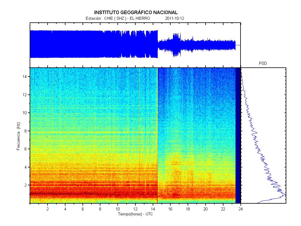
Was there an eruption this morning? The current graph shows the tremors to be calming down about 30 minutes ago.
[img]http://www.01.ign.es/ign/head/volcaSenalesAnterioresDia.do?nombreFichero=CHIE_2011-10-12&ver=s&estacion=CHIE&Anio=2011&Mes=10&Dia=12&tipo=1#[/img ]
[img]http://www.01.ign.es/ign/head/volcaSenalesAnterioresDia.do?nombreFichero=CHIE_2011-10-12&ver=s&estacion=CHIE&Anio=2011&Mes=10&Dia=12&tipo=1#[/img ]
WOW that was an abrupt slowdown of activity!
What would cause such a rapid change? i.e. magma chamber full? change of flow direction where flow has less/more restriction? Pressure released in some underwater event?
I think the speed at which the tremor decreased is very interesting and personally I think we may see another abrupt uptick back to the levels we were seeing.
reply to post by coffeesniffer
It appears that there is a blockage of the flow of magma from where it was erupting. This should most likely trigger earthquakes as the magma needs to find a new outlet. This is a very serious situation and all should be on guard for the next events....
It appears that there is a blockage of the flow of magma from where it was erupting. This should most likely trigger earthquakes as the magma needs to find a new outlet. This is a very serious situation and all should be on guard for the next events....
Amplitude is increasing here...
www.avcan.org...
The sudden stop was thought to be a 'blockage'.
Journalists to attend an urgent meeting at 19.00hrs Spanish time....can't be THAT urgent if they can wait another hour from my time of posting and 2 hours since they announced it! i.e. 3hrs ago!
Rainbows
Jane
www.avcan.org...
The sudden stop was thought to be a 'blockage'.
Journalists to attend an urgent meeting at 19.00hrs Spanish time....can't be THAT urgent if they can wait another hour from my time of posting and 2 hours since they announced it! i.e. 3hrs ago!
Rainbows
Jane
The press release of the meeting has just been published.
Translation of the release:
Source: El Diario de El Hierro
What do you think about this?
As for a possible eruption on land, the Director has answered that they will have to wait for the scientific analysis of data recently collected
They are still unsure of what could happen. Don´t you think so?
Regards,
Ptolomeo
Translation of the release:
Magma finds its way into the sea of La Restinga while there is a strong sulfur odor.
Pevolca has confirmed the existence of two magma spots at one and two miles from La Restinga and highlights the emergence of two centers of eruption.
The Director of Security and Emergency of the Canary Islands, has confirmed that a team of scientists from the National Geographic Institute (IGN) has traveled the coast of La Restinga and discovered the existence of two magma spots with a strong sulfur odor.
This confirms the existence of a volcanic eruption that is taking place on the seabed southwest of La Restinga, with two entrances located at 750 and 500 meters deep, which is releasing magma. They have found dead fish.
With regard to the 400 people evacuated, they say that they must remain out of La Restinga, "waiting for the result of the data analysis to be made by the technicians in the coming hours."
For the director of Security and Emergency of the Canary Islands it is within the danger that a volcanic eruption can have the best of the possible scenarios.
As for a possible eruption on land, the Director has answered that they will have to wait for the scientific analysis of data recently collected"
Source: El Diario de El Hierro
What do you think about this?
As for a possible eruption on land, the Director has answered that they will have to wait for the scientific analysis of data recently collected
They are still unsure of what could happen. Don´t you think so?
Regards,
Ptolomeo
edit on 12-10-2011 by Ptolomeo because: Correction of text
Originally posted by coffeesniffer
WOW that was an abrupt slowdown of activity!
What would cause such a rapid change? i.e. magma chamber full? change of flow direction where flow has less/more restriction? Pressure released in some underwater event?
I think the speed at which the tremor decreased is very interesting and personally I think we may see another abrupt uptick back to the levels we were seeing.
Sounds like sea water has entered fissures and cooled the intrusive magma, however this is a double edged sword as it means that water is finding its way to the magma chamber and the dissolved gasses in the magma now have a route to air pressure which will result in a more explosive push the the surface, that with the temp differential will be explosive..
12/10/2011 @ 20:50 - The scientific teams and researchers working on the island of El Hierro have found earlier this afternoon two green spots in the sea with strong sulfur smells and a large quantity of dead fish southwest of Punta Restinga, which confirms a new volcanic eruption at less distance and depth than the one that occurred on Monday.
This was stated during a press conference in Valverde, the capital of El Hierro by the Director General of Security and Emergency of Canary Islands, Juan Manuel Santana, who has stated that two sources have been located underwater confirming two eruptions, the first one 750 feet deep and two miles (3.7 km) away from the coast and the second one 500 meters under the sea and half mile (2.7 km) from Punta Restinga.
He went on to indicate that these two sources are consistent with the seismic graphs from the last few hours, showing a reduction in tremors (continuous tremor characteristic that produces the magma on its way to the surface) which also indicate a reduction in magmatic pressure in the subsurface.
www.canariesnews.com...
Two new volcano eruptions in Canaries (AFP) – 2 hours ago VALVERDE, Spain — Two new volcanic eruptions were confirmed on Wednesday near Spain's El Hierro island in the Canaries, where 500 people spent another night outside their homes after being evacuated as a precautionary measure.
www.google.com...
edit on 12-10-2011 by Dalke07 because: (no reason given)
Two new underwater volcanic eruptions have occurred off the south coast of El Hierro, the smallest and southernmost island in the Canary Islands. Seismologists say two separate fissures have been identified less than 3.7 kilometres and 2.8 kilometres from La Restinga, a town on the southeast of the island. Authorities have detected a sulphur odour in the area while dead fish have also been spotted floating on the surface of Las Calmas Sea. The fresh eruptions occurred 48 hours after a subsea eruption,
www.irishweatheronline.com...
Originally posted by EvanB
Originally posted by coffeesniffer
WOW that was an abrupt slowdown of activity!
What would cause such a rapid change? i.e. magma chamber full? change of flow direction where flow has less/more restriction? Pressure released in some underwater event?
I think the speed at which the tremor decreased is very interesting and personally I think we may see another abrupt uptick back to the levels we were seeing.
Sounds like sea water has entered fissures and cooled the intrusive magma, however this is a double edged sword as it means that water is finding its way to the magma chamber and the dissolved gasses in the magma now have a route to air pressure which will result in a more explosive push the the surface, that with the temp differential will be explosive..
If I understood it well, I'm not familiar with volcanic activity from that region so I trust others on this one, there is no chamber (caldera) under El Hierro.
What we are dealing with here is magma rising from underalying magma layers, trying to find it's way to the surface.
So the possible danger from seawater entering a magma chamber can probably be excluded.
Although
A scientific suggested that we are looking at the birth of a volcano here at El Hierro. If that's the case a magma chamber is being build.
Here's a picture that Jon has found and explaining a bit the presumed actual situation
www.elpais.com...
edit on 13-10-2011 by Nidwin because: (no
reason given)
Pressure was released after two submarine eruption ..
Pressure and eq's slowly moving towards to North ..
La Palma graphs don't have update last 20 hours ..
Looks like tremors and pressure slowly increasing again ..
www.canariesnews.com...
El Hierro Elevation
Pressure and eq's slowly moving towards to North ..
La Palma graphs don't have update last 20 hours ..
Looks like tremors and pressure slowly increasing again ..
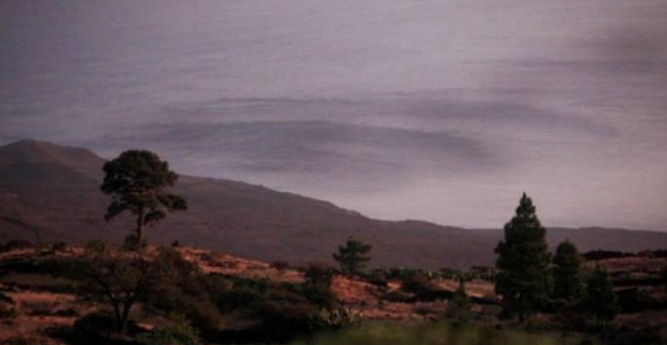
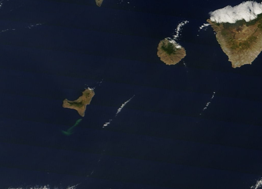
13/10/2011 @ 11:41 – Residents of El Hierro have been observing the formation of ‘green patches’ on the sea surface, some 1 and a half miles from land, which appear to be growing in size at a rapid pace since this morning.
13/10/2011 @ 10:32 – Tremors continue on the island of El Hierro, see the latest chart from the IGN.
13/10/2011 @ 09:45 – Of the 50 tourists evacuated from the are of La Restinga on Tuesday, 15 still remain on the island. The majority of the tourists have decided to return to their contry of origin, but some have decided to remain on the island. It has now been 15 days since some of the residents were evacuated from their homes.
13/10/2011 @ 09:01 – A new earthquake has been detected, this time to the north-east of the island. Until now, all the earthquakes have been located to the south coast. It took place at 05:10:36 (local time) and registered 1.7 on the Richter scale.
13/10/2011 @ 08:55 – The ship normally used by Telefonica to lay underwater fibre optic cables is making its way from Tenerife to El Hierro to make use of itsunderwater robot with cameras to get images of the eruption and seabed.
13/10/2011 @ 03:12 – The specialists and researchers working from the La Restinga area of El Hierro have confirmed that there is clear evidence of two underwater eruptions which have pushed magma up to the surface of the water.
www.canariesnews.com...
El Hierro Elevation
edit on 13-10-2011 by Dalke07 because: (no reason given)
reply to post by Dalke07
Thank you for keeping us informed. It is hard to keep an eye on what's going on when one is at work and only throw a quick glance for updates.
It looks like it could be another 'wait and see' evening again tonight!
Rainbows
Jane
Thank you for keeping us informed. It is hard to keep an eye on what's going on when one is at work and only throw a quick glance for updates.
It looks like it could be another 'wait and see' evening again tonight!
Rainbows
Jane
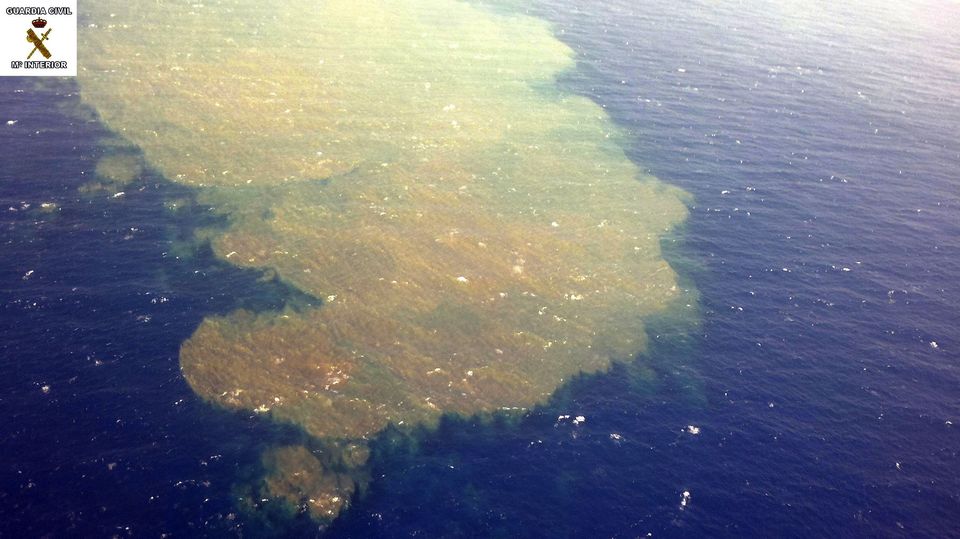
13/10/2011 @ 13:55 – First images of the sea surface off the coast of La Restinga.
www.canariesnews.com...
lance-modis.eosdis.nasa.gov...
www.canariesnews.com...
lance-modis.eosdis.nasa.gov...
edit on 13-10-2011 by Dalke07 because: (no reason
given)
Can someone explain what this means?
The following information has just been published by the Spanish media (translated):
Source: Diario El Hierro
Ok. I am not an expert, and might be wrong, but they are saying that there is magma under the island...
Is a volcanic eruption possible on the island?
Regards,
Ptolomeo
The following information has just been published by the Spanish media (translated):
Anomalous emissions of carbon dioxide in the area of eruption have been detected.
Scientists of the ITER and Involcan have detected anomalous emissions of carbon dioxide previous to the tremor.
Experts working since last July in the island of El Hierro have made over 4250 measures of diffuse flow of carbon dioxide (CO2) through 7 scientific observation campaings finding diffuse volcanic gas emissions across all the island´s surface.
Last Monday, about 5.15 am, the IGN registered a small volcanic tremor (low frequency) at all their seismic stations in El Hierro. Before this, the diffuse flow of carbon dioxide showed 990-40 ton./day, above the normal values for the island, as well as above the emissions of the last 3 months.
Normal emissions for El Hierro are about 339 ton./day, and the normal emissions range from 142 to 866 ton./day
The data of the anomalous emissions reflect a clear process of magma movement in the subsurface of the island.
Source: Diario El Hierro
Ok. I am not an expert, and might be wrong, but they are saying that there is magma under the island...
Is a volcanic eruption possible on the island?
Regards,
Ptolomeo
edit on 13-10-2011 by Ptolomeo because: Correction of text
reply to post by Ptolomeo
You can see last earthquakes are below island ..
www.02.ign.es...
Pressure was released again very probably closer to land, graphs go down at 14:20 UTC ..
The volcanic spots close to 1.85 kilometers from La Restinga
13.10.2011 / 17:40 h
www.abc.es...
Latest video ..
i.imgur.com...
You can see last earthquakes are below island ..
www.02.ign.es...
Pressure was released again very probably closer to land, graphs go down at 14:20 UTC ..
The volcanic spots close to 1.85 kilometers from La Restinga
13.10.2011 / 17:40 h
Las Palmas de Gran Canaria, Oct 13 (EFE) .- The spots generated by the underwater eruption was taking place in the Sea of Calm are already a mile (1.85 km) from La Restinga, the southernmost population the island of El Hierro, as shown by a photograph released this afternoon by the Canarian Government.
These aerial images, taken by the National Geological Survey and the National Research Council, shows a patch of light green, with tan areas, approaching the coast, the Canary Islands government said in a statement.
Experts believe that spot in the sea "could be associated with greater depth fumaroliana emission of 150 meters" and has "different characteristics" to the observed yesterday.
During the afternoon of Wednesday, the team moved to El Hierro announced that it had detected two spots in the sea with a strong sulfur smell and dead fish at a distance of between 1.5 and 2 nm (2.77 and 3.70 kilometers).
As explained by the Director General of Security and Emergency Canarian Government, these two spots turn signal eruptive two submarines, one to 2 miles and 750 feet deep and another 1.5 miles of the coast and 500 meters under the sea .
The spots generated by this submarine eruption can be seen with the naked eye from the highlands of El Hierro, in which several people have gathered to observe this natural phenomenon, as has been witnessed on terrero Efe. EFE
www.abc.es...
Latest video ..
i.imgur.com...
edit on 13-10-2011 by Dalke07 because: (no reason given)
reply to post by Ptolomeo
The whole of the Island is volcanic and was formed by volcanic events it is a shield volcano. Think of the Islands of Hawaii.
Source
Shield volcanoes do not normally have highly explosive events - they just sort of oozzee.
So the answer to you question - Yes, it is believed there is magma under the whole of the Island and No, unlikely explosive event.
The whole of the Island is volcanic and was formed by volcanic events it is a shield volcano. Think of the Islands of Hawaii.
El Hierro Island covers an area of 278 sq km, and contains three well-defined ridges, arranged at approximately 120 degrees. According to the hotspot model of volcano formation, the current location of the Canary islands hotspot is under Hierro Island.
El Hierro volcano is still in its juvenile stage of shield growth, and has been modified by gravitational spreading which caused gigantic landslides. There are three volcanic structures on El Hierro Island - elongated topographic ridge (the Southern Ridge) and two semi-circular volcanic cones (Tinor volcano, El Golfo volcano).
Source
Shield volcanoes do not normally have highly explosive events - they just sort of oozzee.
So the answer to you question - Yes, it is believed there is magma under the whole of the Island and No, unlikely explosive event.
reply to post by Anmarie96
Thank you for your answer.
Let´s hope there is no explosive event. Scientists and authorities here do not seem very sure of what can really happen next...
Regards,
Ptolomeo
Thank you for your answer.
Let´s hope there is no explosive event. Scientists and authorities here do not seem very sure of what can really happen next...
Regards,
Ptolomeo
i wonder based on wind factors and whatnot if it would disrupt any major flightpaths and potentially ground flights?
Originally posted by UnrelentingLurker
i wonder based on wind factors and whatnot if it would disrupt any major flightpaths and potentially ground flights?
Doubtfull.
Even if we would have a surface eruption there I don't expect any big vents as it's a shield volcano.
The 2 main dangers would be toxic gasess and lava flows from opened fissures.
It's not going to be the same kind of eruption as we had with Eyja past year. It won't be a vent going up 15-25km high in the sky.
15/10/2011 @ 18:09 – A new eruption has been detected on El Hierro at just 2.4 km from the coast of La Restinga and 150 meters deep, according to
data provided in a press conference by Juan Manuel Santana, Director General of Security. He confirmed that there is “bubbling” in the sea surface
and pyroclastic material floating as a result of magma flowing in shallow waters. See the latest video under ‘Featured Video’ to the right or
click on the link below.
www.canariesnews.com...
www.canariesnews.com...
edit on 15-10-2011 by Dalke07 because: (no reason given)
The La Palma seismic recording station does NOT show more than half a day
data compared to all the other stations! ATSminded folks ask "WHY?!?"...
THERE IS NO DATA AT ALL FROM TODAY, OCT 17...
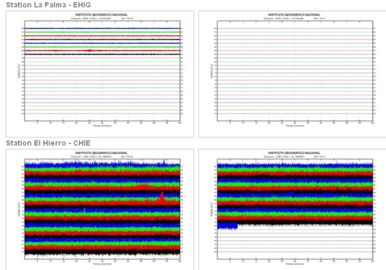
Link to the spanish 'USGS' (NGI) site here....
data compared to all the other stations! ATSminded folks ask "WHY?!?"...
THERE IS NO DATA AT ALL FROM TODAY, OCT 17...
Link to the spanish 'USGS' (NGI) site here....
new topics
-
12 jurors selected in Trump criminal trial
US Political Madness: 4 minutes ago -
Iran launches Retalliation Strike 4.18.24
World War Three: 18 minutes ago -
Israeli Missile Strikes in Iran, Explosions in Syria + Iraq
World War Three: 49 minutes ago -
George Knapp AMA on DI
Area 51 and other Facilities: 6 hours ago -
Not Aliens but a Nazi Occult Inspired and then Science Rendered Design.
Aliens and UFOs: 6 hours ago -
Louisiana Lawmakers Seek to Limit Public Access to Government Records
Political Issues: 8 hours ago -
The Tories may be wiped out after the Election - Serves them Right
Regional Politics: 10 hours ago
top topics
-
BREAKING: O’Keefe Media Uncovers who is really running the White House
US Political Madness: 13 hours ago, 25 flags -
George Knapp AMA on DI
Area 51 and other Facilities: 6 hours ago, 19 flags -
Biden--My Uncle Was Eaten By Cannibals
US Political Madness: 14 hours ago, 18 flags -
Israeli Missile Strikes in Iran, Explosions in Syria + Iraq
World War Three: 49 minutes ago, 7 flags -
"We're All Hamas" Heard at Columbia University Protests
Social Issues and Civil Unrest: 14 hours ago, 7 flags -
Louisiana Lawmakers Seek to Limit Public Access to Government Records
Political Issues: 8 hours ago, 7 flags -
So I saw about 30 UFOs in formation last night.
Aliens and UFOs: 12 hours ago, 5 flags -
Not Aliens but a Nazi Occult Inspired and then Science Rendered Design.
Aliens and UFOs: 6 hours ago, 3 flags -
Do we live in a simulation similar to The Matrix 1999?
ATS Skunk Works: 12 hours ago, 3 flags -
The Tories may be wiped out after the Election - Serves them Right
Regional Politics: 10 hours ago, 3 flags
active topics
-
Candidate TRUMP Now Has Crazy Judge JUAN MERCHAN After Him - The Stormy Daniels Hush-Money Case.
Political Conspiracies • 388 • : matafuchs -
Iran launches Retalliation Strike 4.18.24
World War Three • 3 • : JimmyNeutr0n -
12 jurors selected in Trump criminal trial
US Political Madness • 0 • : JadedGhost -
Israeli Missile Strikes in Iran, Explosions in Syria + Iraq
World War Three • 11 • : Unknownparadox -
It has begun... Iran begins attack on Israel, launches tons of drones towards the country
World War Three • 882 • : matafuchs -
British TV Presenter Refuses To Use Guest's Preferred Pronouns
Education and Media • 62 • : fringeofthefringe -
So I saw about 30 UFOs in formation last night.
Aliens and UFOs • 21 • : BrotherKinsMan -
President BIDEN Warned IRAN Not to Attack ISRAEL - Iran Responded with a Military Attack on Israel.
World War Three • 42 • : WeMustCare -
MULTIPLE SKYMASTER MESSAGES GOING OUT
World War Three • 36 • : Irishhaf -
-@TH3WH17ERABB17- -Q- ---TIME TO SHOW THE WORLD--- -Part- --44--
Dissecting Disinformation • 535 • : cherokeetroy