It looks like you're using an Ad Blocker.
Please white-list or disable AboveTopSecret.com in your ad-blocking tool.
Thank you.
Some features of ATS will be disabled while you continue to use an ad-blocker.

Spiral weather patterns over midwest.
page: 11
share:
Hello all,
I'm a resident of the michiana area and over the past week I've noticed a large spiral pattern on the RADAR. I'm no weather expert, but I've never seen the radar signatures move from East to West, let alone form a huge spiral pattern. Is there an explanation for this? I don't want to jump to conclusions but I fond this very odd. I've searched google and weather sites and it's not being mentioned anywhere. I've shown the radar to my friends and family and everyone agrees that this is not normal. La Ninia? HAARP? Could anyone provide an answer to this phenomenon? Thanks in advance.
I'm a resident of the michiana area and over the past week I've noticed a large spiral pattern on the RADAR. I'm no weather expert, but I've never seen the radar signatures move from East to West, let alone form a huge spiral pattern. Is there an explanation for this? I don't want to jump to conclusions but I fond this very odd. I've searched google and weather sites and it's not being mentioned anywhere. I've shown the radar to my friends and family and everyone agrees that this is not normal. La Ninia? HAARP? Could anyone provide an answer to this phenomenon? Thanks in advance.
Watch the first 15 minutes of Wizard of Oz. This will help explain everything.
Iowa Resident
Iowa Resident
edit on 28-9-2011 by kellynap43 because: (no reason given)
I live in your area, and I've seen the clouds move east to west from time to time before these "apocalyptic times" we're in. Monday afternoon, I even
mentioned how the clouds on the weather satellite looked like the remnants of a hurricane.
edit on 28-9-2011 by satron because: (no reason
given)
I believe they are informally referred to as "terracanes" and are fairly common... I remember a few posts about similar phenomenona back in April
and May.
reply to post by Icon_xof
Have a look at thiswww.colinandrews.net...
see if its like what you are looking at.There is a thread on ATS somewhere in the dungeon
Have a look at thiswww.colinandrews.net...
see if its like what you are looking at.There is a thread on ATS somewhere in the dungeon
edit on 28-9-2011 by 12voltz because: (no reason
given)
Originally posted by Icon_xof
Hello all,
I'm a resident of the michiana area and over the past week I've noticed a large spiral pattern on the RADAR. I'm no weather expert,
Do you therefore understand that radar is simply that - a radar return?
reply to post by Icon_xof
What radar are we talking about here?
Do you a screenshot of the radar data?
What radar are we talking about here?
Do you a screenshot of the radar data?
Originally posted by kellynap43
Watch the first 15 minutes of Wizard of Oz. This will help explain everything.
Iowa Residentedit on 28-9-2011 by kellynap43 because: (no reason given)
^this
and its nothing unusual around here
reply to post by Icon_xof
I will as soon as you tell me where michiana is? Is it one Obama's lost 57 states?
But seriously Tom Skilling (Chicago) doesn't seem to have an issue with this formation. Trust the Skilling.
www.chicagoweathercenter.com...
I will as soon as you tell me where michiana is? Is it one Obama's lost 57 states?
But seriously Tom Skilling (Chicago) doesn't seem to have an issue with this formation. Trust the Skilling.
www.chicagoweathercenter.com...
Its just a low pressure system which has been sitting over the midwest since last friday. Your most likely seeing the precipitation which is moving
around the low in a counterclockwise fashion hence clouds moving east to west. Nothing really sinister or odd just weather doing its thing
i have noticed it too and am in southwestern ontario. I check intellicast all the time and if you chose cloud cover and watch the movement it
certainly has spiral rotation and has had for the last several days.
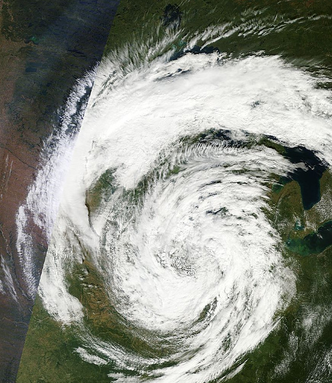
It's this (image from yesterday)
lance-modis.eosdis.nasa.gov...
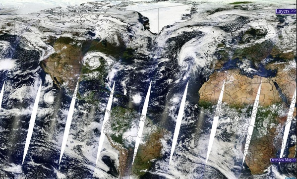
In global context:
lance-modis.eosdis.nasa.gov.../27/2011
Here's an old animation of a month of weather. Still pretty cool
lance-modis.eosdis.nasa.gov...
In global context:
lance-modis.eosdis.nasa.gov.../27/2011
Here's an old animation of a month of weather. Still pretty cool
edit on 28-9-2011 by Uncinus because: (no reason given)
reply to post by fireysnowman29
Yep. Just a typical day in the midwest. Hence the reason we have so many Wind Generators around here now.
Yep. Just a typical day in the midwest. Hence the reason we have so many Wind Generators around here now.
Thanks for the input all. Michiana is just a name for the Michigan Indiana border area. So it's a low pressure system that's causing this? That's a
relief I guess. I'll have to do some research on this phenomenon as I've never seen a hurricainish radar signature like this in my area. And thanks
for the pics, they're pretty awesome. Terricane is a pretty fitting term for this.
I guess I'm just a little paranoid because I've been having very strange and vivid dreams about the weather for the past month or so. In one I was living in the early years of the next ice-age, and the few since then have all been about seeing strange cloud formations. They're almost impossible to describe. Some like long horizontal tornadoes, others like huge storm clouds, but all are different colors.
It's strange because I haven't been able to recall many dreams the past couple years. Then just before the earthquake and hurricane hit the East coast, these dreams start. Some with such intensity that they wake me from a dead sleep.
Sorry to ramble, it's just been on my mind a lot and then this low pressure system comes along and just freaks me out, lol. Thanks again all.
Originally posted by Icon_xof
and the few since then have all been about seeing strange cloud formations. They're almost impossible to describe. Some like long horizontal tornadoes, others like huge storm clouds, but all are different colors.
It's strange because I haven't been able to recall many dreams the past couple years. Then just before the earthquake and hurricane hit the East coast, these dreams start. Some with such intensity that they wake me from a dead sleep.
Those clouds exist read this:
www.wired.com...
And I lived in the Chicago area for a lot of years, traveled to Indiana and Michigan a bunch of times never heard that phrase before. Learn something new every day!
I'm in the Michiana borderland on the "-iana" side. It's just normal weather. Storms spiral, sometime more obviously than others. I wish this
one would stop......my yard has needed cutting for days and it's been raining almost constantly. Brief periods of time of sunlight don't dry the
lawn enough to cut before more rain. We are missing prime fall sightseeing weather.
reply to post by Icon_xof
I live in Ohio...I see them all the time. But I'm a weather nerd It's nothing new or weird.. low pressure front moving through.
www.weather.com...
I live in Ohio...I see them all the time. But I'm a weather nerd It's nothing new or weird.. low pressure front moving through.
www.weather.com...
edit on 9/28/2011 by mnmcandiez because:
(no reason given)
reply to post by stars15k
I totally feel you. I'm in NW Indiana and the one day it didn't rain was my son's birthday, so my yard is starting to look like a hippy. =]
I totally feel you. I'm in NW Indiana and the one day it didn't rain was my son's birthday, so my yard is starting to look like a hippy. =]
That's a great example of a Cutoff Low.
"Cutoff lows bring days of dreary weather
A cutoff, upper-air low occurs when a counterclockwise wind circulation becomes separated from the main belt of west-to-east winds in the jet stream high above the earth's surface.
With nothing to steer a cutoff low, it can simply sit and spin for days, often bringing damp, dreary weather.
Such lows usually form when a strong wind speed maximum riding along the main belt of westerly jet stream winds dives into a deep upper-level trough or dip in the jet. As the wind speed maximum dives into the bottom of the trough, it elongates the trough and also helps build a large downstream ridge.
The combination of the deepening trough and the strengthening downstream ridge allows the bottom portion of the trough to separate from the main belt of the westerlies. As a result, a large, circular, counterclockwise circulation forms high above the earth's surface.
Often, areas of low pressure at the earth's surface are associated with upper-level troughs and cutoff lows.
A cutoff low is usually slow moving and won't exit a region until it is picked up by the westerly steering flow. Sometimes they unravel as they spin, eventually weakening and then dissipating.
Either way, cutoff lows almost always bring several days of cloudy, dreary weather with periods of rain or snow. "
Source: www.usatoday.com...
new topics
-
Nearly 70% Of Americans Want Talks To End War In Ukraine
Political Issues: 5 minutes ago -
Late Night with the Devil - a really good unusual modern horror film.
Movies: 1 hours ago -
Cats Used as Live Bait to Train Ferocious Pitbulls in Illegal NYC Dogfighting
Social Issues and Civil Unrest: 3 hours ago -
The Good News According to Jesus - Episode 1
Religion, Faith, And Theology: 5 hours ago -
HORRIBLE !! Russian Soldier Drinking Own Urine To Survive In Battle
World War Three: 7 hours ago -
Bobiverse
Fantasy & Science Fiction: 10 hours ago -
Florida man's trip overseas ends in shock over $143,000 T-Mobile phone bill
Social Issues and Civil Unrest: 10 hours ago
top topics
-
Florida man's trip overseas ends in shock over $143,000 T-Mobile phone bill
Social Issues and Civil Unrest: 10 hours ago, 8 flags -
SETI chief says US has no evidence for alien technology. 'And we never have'
Aliens and UFOs: 14 hours ago, 7 flags -
Cats Used as Live Bait to Train Ferocious Pitbulls in Illegal NYC Dogfighting
Social Issues and Civil Unrest: 3 hours ago, 7 flags -
This is our Story
General Entertainment: 16 hours ago, 4 flags -
Former Labour minister Frank Field dies aged 81
People: 12 hours ago, 4 flags -
Bobiverse
Fantasy & Science Fiction: 10 hours ago, 3 flags -
Late Night with the Devil - a really good unusual modern horror film.
Movies: 1 hours ago, 2 flags -
HORRIBLE !! Russian Soldier Drinking Own Urine To Survive In Battle
World War Three: 7 hours ago, 2 flags -
The Good News According to Jesus - Episode 1
Religion, Faith, And Theology: 5 hours ago, 0 flags -
Nearly 70% Of Americans Want Talks To End War In Ukraine
Political Issues: 5 minutes ago, 0 flags
active topics
-
British TV Presenter Refuses To Use Guest's Preferred Pronouns
Education and Media • 144 • : Consvoli -
Cats Used as Live Bait to Train Ferocious Pitbulls in Illegal NYC Dogfighting
Social Issues and Civil Unrest • 9 • : ImagoDei -
Nearly 70% Of Americans Want Talks To End War In Ukraine
Political Issues • 0 • : Consvoli -
President BIDEN Vows to Make Americans Pay More Federal Taxes in 2025 - Political Suicide.
2024 Elections • 101 • : ImagoDei -
Late Night with the Devil - a really good unusual modern horror film.
Movies • 3 • : Hecate666 -
HORRIBLE !! Russian Soldier Drinking Own Urine To Survive In Battle
World War Three • 23 • : Disgusted123 -
Hi folks I'm Leon Grad
Introductions • 9 • : leongrad -
The Reality of the Laser
Military Projects • 41 • : 5thHead -
Thousands Of Young Ukrainian Men Trying To Flee The Country To Avoid Conscription And The War
Other Current Events • 136 • : NorthOS -
Florida man's trip overseas ends in shock over $143,000 T-Mobile phone bill
Social Issues and Civil Unrest • 16 • : grey580
1