It looks like you're using an Ad Blocker.
Please white-list or disable AboveTopSecret.com in your ad-blocking tool.
Thank you.
Some features of ATS will be disabled while you continue to use an ad-blocker.

New ATS Member Claiming To Have Important Warning/Information. You Be The Judge...
page: 59share:
reply to post by kdog1982
I wouldn't make much of the PSA information. The shakeout program is a known factor and has been in place for a few years. The adverts were bought and produced well in advance of this month's shakeout event. As I said before, the Californians out here can observe if there's a change in tone from last year. But that would be subjective and hard to accurately gauge.
I wouldn't make much of the PSA information. The shakeout program is a known factor and has been in place for a few years. The adverts were bought and produced well in advance of this month's shakeout event. As I said before, the Californians out here can observe if there's a change in tone from last year. But that would be subjective and hard to accurately gauge.
I got carried away,and should post this stuff here instead.
www.physicsforums.com...
www.dmr.nd.gov...
Another interesting theory is glacial rebound.
That is the weight of the ice on the crust actually causing it to depress.
Now,take in fact that many glaciers have retreated,and iceshelves have become smaller and broken off.
www.dmr.nd.gov...
My words.
I think I screwed that up enough!
Giving you guys a tid bit of info,as I am currently researching it. The effect of the moon on Earths lithosphere. Besides causing the oceans to wane back and forth,the tides,it also causes the earth's crust to deform,or "bulge". ~ 30 cm, then the tidally induced average radial expansion is ~ 5 cm (ie., the Earth's crust oscillates from -25 to +35 cm). This result seems plausible, and may be Order-of-Magnitude accurate. www.physicsforums.com...
www.physicsforums.com...
Another interesting theory is glacial rebound. That is the weight of the ice on the crust actually causing it to depress. Now,take in fact that many glaciers have retreated,and iceshelves have become smaller and broken off. People often wonder how thick the glacial ice was that covered North Dakota. When asked, my response has usually been "I don't know," but sometimes I've speculated if the questioner has persisted. My answer is usually something like "The ice may have been as much as a mile thick in the northeastern corner of North Dakota at Pembina, which is where I think it was the thickest in North Dakota," or "It was up to 8,000 feet thick near Hudson Bay." But I've never done any kind of study myself to verify whether my estimate for North Dakota was even close to being correct. This "Geologic Note" will deal with the question of the thickness of the glacial ice and with isostatic depression and rebound of the earth's crust due to the effects of glaciation, especially in eastern North Dakota. There would seem to be a number of ways to get at the answer to the question "how thick was the glacier?" We can make comparisons with existing glaciers in places like Greenland and Antarctica, but these may or may not be typical of the glaciers that covered North Dakota 20,000 years ago, near the maximum of the most recent glaciation, the Late Wisconsinan glaciation. Another way of indirectly getting at the answer of how much ice existed during the Ice Age is to determine the amount that sea level dropped at the time - the amount of the drop must represent the water that was tied up as glacial ice during the Ice Age. www.dmr.nd.gov...
www.dmr.nd.gov...
Another interesting theory is glacial rebound.
That is the weight of the ice on the crust actually causing it to depress.
Now,take in fact that many glaciers have retreated,and iceshelves have become smaller and broken off.
www.dmr.nd.gov...
Anyone living along the coast knows that at certain times,the tides are "running".Meaning the are more extreme then at other times of the year. I learned this during shrimping season in Charleston. But,It also affects the lithosphere,or crust of the Earth.
My words.
I think I screwed that up enough!
edit on 3-10-2011 by kdog1982 because: (no reason given)
edit on 3-10-2011 by kdog1982 because: (no reason given)
reply to post by zworld
Two thoughts. Concerning land over old ocean bed, I hope someday to map out where and how long ago this occurred. This pertains to methane hydrate (MH) formation. Areas that were once in what they call a hydrate stability zone, meaning the pressure and temperature were right for turning methane gas into gas trapped in an ice lattice (methane hydrate), moves out of this zone over time as they get buried deeper, and the temps get to hot for ice, dissociating the hydrates. I call these relic hydrates, pockets of methane gas under intense pressure. I believe most kicks from encountering gas (like Deepwater Horizon) during the drilling process are actually hitting relic hydrates, even on land, as deep under the surface there are areas of ocean bed from millions of years ago that once were in the hydrate stability zone. The reason I bring that up is because MH is affected by EQs in a big way. Massive ocean landslides and other deformations occur when big EQs hit thick MH beds. But thats a different angle to EQs and one I might start a new thread on, MH in general. Its going to be one of the biggest concerns we face in the very near future as the corporate world is banking the grid on MH extraction.
Message me if and when you do a thread on this because it interests me BIG TIME. I have heard a lot of this specualtion in regards to Methane pockets and would love to learn more. I think there is something here and maybe this is why we do notice a slight change in EQ's when we have a massive Geomagnetic storm.
I have no idea....still in the infancy stage of learning and pondering what causes an EQ. If and when you do create this thread please make it easy for the newbies learning, meaning keep it simple.
reply to post by zworld
Zworld...I thought of your maps and all he info you posted, when I saw this 3.1 on the USGS page:
earthquake.usgs.gov...
Its 80 miles WSW off the coast (from Eureka, CA) but right in that 'active' area you noted on your map.
Zworld...I thought of your maps and all he info you posted, when I saw this 3.1 on the USGS page:
earthquake.usgs.gov...
Its 80 miles WSW off the coast (from Eureka, CA) but right in that 'active' area you noted on your map.
First, I must ask for forgiveness for this monster post I am about to unleash...
Searching one of the acronyms you use below yields, among other things, this .pdf (3.3 MB) in which, among other things, the following is said:
We've come a long way since this map, haven't we, but the general public is unaware of how much more advanced this is. Even we are only able to make educated guesses on how well they can dial down the precision now.
And
So we have a whole host of high-tech tools being directed toward earthquake research, which we've known for a bit now. A bit further on in the document we have this:
Now we know where those figures come from...
Continuing:
The last question is the whole enchilada. The entire reason this thread exists and the (purported) purpose for which attention has been drawn to this topic.
This is a pretty confident sounding statement (of course it would be especially if it is to be read by funding agencies) of the ability of the science to produce desired results.
A bit further on...
Questions, questions, always questions. That's good, I've maintained often that questions are sometimes more valuable and useful than answers.
Like how is it that the continental crust is SO much older than ANY oceanic crust by several orders of magnitude?
(to be continued)
Originally posted by tmiddlebrook36
snip
What I’m about to share with you is 100% fact checkable and I encourage, again, everyone to do just that. The inception of research began in 1992 (less than one year after I began my career), after the 7.3 Landers, CA earthquake and subsequent 6.5 Big Bear, CA earthquake that occurred only three hours later. This single, heavily studied, event changed the way geologist research event sequences to this very day, and not because the two earthquakes were initially thought to be two separate events, than eventually connected via cause, but because of the research that surrounded them.
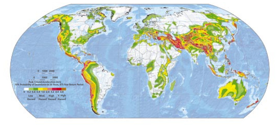
Searching one of the acronyms you use below yields, among other things, this .pdf (3.3 MB) in which, among other things, the following is said:
This seismic hazard map was produced by the Global Seismic Hazard Assessment Program (GSHAP).␣ Launched in 1992, GSHAP promoted a regionally coordinated, homogeneous approach to seismic hazard evaluation, intended for national decision makers and engineers responsible for land-use planning and improved building design and construction.
We've come a long way since this map, haven't we, but the general public is unaware of how much more advanced this is. Even we are only able to make educated guesses on how well they can dial down the precision now.
And
The NSF EarthScope initiative involves four integrated components: USArray, a moving array of broadband seismic instruments; the San Andreas Fault Observatory at Depth (SAFOD), involving deep drilling and instrumentation at depth; the Plate Boundary Observatory (PBO), primarily an array of continuous GPS stations and strainmeters to be deployed in the western U.S.; and a dedicated InSAR mission for obtaining synoptic information about crustal deformation globally. The first three components of EarthScope are expected to be led by NSF, but NASA can contribute to PBO through its accumulated expertise in space-based geodesy and GPS. NASA should be the lead for a dedicated InSAR mission.
So we have a whole host of high-tech tools being directed toward earthquake research, which we've known for a bit now. A bit further on in the document we have this:
emphasis mine
Earthquakes are among nature’s most complex phenomena, threatening many of the world’s population centers. A great Pacific Rim earthquake near a major economic area might cause damages well in excess of one trillion dollars and tens of thousands of casualties. Reaching an understanding of earthquake fault systems is required in order to address the issue of their predictability, with the goal of mitigating their impact
Now we know where those figures come from...
Continuing:
Key questions include:
• How do individual faults behave and interact as part of an integrated system?
• What are the mechanical properties of the crust and mantle that control deformation?
• To what extent can earthquakes be forecast
The last question is the whole enchilada. The entire reason this thread exists and the (purported) purpose for which attention has been drawn to this topic.
The ensemble of data combined with advanced geophysical modeling will allow quantitative prediction of many aspects of fault zone deformation.
This is a pretty confident sounding statement (of course it would be especially if it is to be read by funding agencies) of the ability of the science to produce desired results.
A bit further on...
We have a relatively poor understanding of the dynamics of subduction at ocean trenches, or the mechanism for initiation of new subduction zones. While we generally understand the large-scale thermal structure of mid-ocean ridges and oceanic plates with ages less than about 50 million years, there are still questions about structure at small spatial scales as well as for older oceanic plates and continental plates.
Questions, questions, always questions. That's good, I've maintained often that questions are sometimes more valuable and useful than answers.
emphasis mine
While oceanic crust is thought to be formed by partial melting of mantle rock at depth beneath an ocean ridge, we don’t understand how continental crust is formed or whether recycling of the lower continental crust into the mantle is an important process.
Like how is it that the continental crust is SO much older than ANY oceanic crust by several orders of magnitude?
(to be continued)
reply to post by jadedANDcynical
(continued from previous post)
On to the magnetic field:
So, this dynamo (which is theorized to exist) has somehow, suddenly decided to start spinning in the opposite direction? That's the only thing that makes sense to me I this context. A dynamo (traditional science maintains is made up of molten iron) which generates the earth's magnetic field.
In other words, at the temperatures that are thought to exist within the core of the earth, iron is not magnetic. Hmm, what do you make of that?
See this post and the two of mine following it for more detail on this topic.
Anyway, all of that based off of one search regarding “SESWG”
Whew!
I may have more tomorrow on this (fact checking), but right now I must seek the to pass through the gates of horn and ivory in the sunless lands.
Fare well for now.
(continued from previous post)
On to the magnetic field:
Over the past 150 years, the main (axial dipole) component of the Earth’s magnetic field has decayed by nearly 10%, a rate ten times faster than if the dynamo were simply switched off. To that extent, the dynamo today is operating more as an anti-dynamo, a destroyer of the dipole part of the field. Intriguingly, this decay rate is characteristic of magnetic reversals, which paleomagnetic observations have shown occur on average, though with great variability, about once every half million years
So, this dynamo (which is theorized to exist) has somehow, suddenly decided to start spinning in the opposite direction? That's the only thing that makes sense to me I this context. A dynamo (traditional science maintains is made up of molten iron) which generates the earth's magnetic field.
As molten iron cools down it crystallizes at 1538°C into its δ allotrope, which has a body-centered cubic (bcc) crystal structure. As it cools further its crystal structure changes to face-centered cubic (fcc) at 1394 °C, when it is known as γ-iron, or austenite. At 912°C the crystal structure again becomes bcc as α-iron, or ferrite, is formed, and at 770°C (theCurie point, Tc) iron becomes magnetic
In other words, at the temperatures that are thought to exist within the core of the earth, iron is not magnetic. Hmm, what do you make of that?
See this post and the two of mine following it for more detail on this topic.
Anyway, all of that based off of one search regarding “SESWG”
Whew!
I may have more tomorrow on this (fact checking), but right now I must seek the to pass through the gates of horn and ivory in the sunless lands.
Fare well for now.
content.usatoday.com...
www.emergencymgmt.com...
www.emergencymgmt.com...
edit on 5-10-2011 by Robin Marks because: (no reason given)
reply to post by Robin Marks
Looks like a swarm of stories about earthquake prediction is beginning:
Teams compete to forecast quakes
ETA:
I'm actually reminded of this:
Would stories about earthquake prediciton not fall in line with this statement? Readying the public for the possibility, thus engendering an increased likelihood of any warnings given being accepted and acted upon?
Think about this, if some agency came out and told people that they are actually pretty sure about earthquake activity to the degree that certain (highly damaging) quakes could be forecast reliably, how much hubbub do you think would be kicked up obscuring the possibility of a major quake with endless debate and questioning.
Actually, that sounds like what's been going on in this thread
Looks like a swarm of stories about earthquake prediction is beginning:
Teams compete to forecast quakes
ETA:
I'm actually reminded of this:
emphasis mine
As I’ve mentioned to look for increasingly obvious programing and PSA’s over the next month, I’ve provided a benchmark for my credibility. Tomorrow nigh KLCS is running and entire program, live, entitled “TOTALLY UNPREPARED”. Please watch it as this is what I’m referring to. I’m not sure how to be more vulnerable here to make my point. Obviously, I cannot reveal my true identity and I would ask those of you who are trying to expose me to redirect your attention to spreading the word.
Would stories about earthquake prediciton not fall in line with this statement? Readying the public for the possibility, thus engendering an increased likelihood of any warnings given being accepted and acted upon?
Think about this, if some agency came out and told people that they are actually pretty sure about earthquake activity to the degree that certain (highly damaging) quakes could be forecast reliably, how much hubbub do you think would be kicked up obscuring the possibility of a major quake with endless debate and questioning.
Actually, that sounds like what's been going on in this thread
edit on 5-10-2011 by jadedANDcynical because: thoughts on the matter
edit on 5-10-2011 by jadedANDcynical because: typos and
punctiation
Here's a prediction. And I'm not a team of scientists. I'm just some guy.
But I can claim to have predicted an earthquake swarm within hours and documented it on ATS.
I take the whole middlebrook affair seriously. Because if I thought they were legit, I'd be focusing attention on helping, rather than put it in perspective. I took the Arkansas earthquake swarm serious, and did everything, and more, to help spread the word. I am sometimes burdened by guilt thinking, What if middlebrook is real and you've distracted the messenger and this prevented people from taking the matter serious and preparing. I've asked myself the question many times. And I've never been able to get behind the "cause". I think the discussion on earthquake prediction is marvelous, because I believe it's possible. But it is not exact. And therein lies the problem.
Scientists and politicians don't want to be held accountable for failure. Either in failing to predict and warn, or warn and have nothing happen. When they predict a major hurricane and evacuate, and it turns out to be a gusty wind, people fail to heed the next warning. It's a real problem. So, there's forecasts and probabilities. It will be a long time before we have accurate predictions that are widely used by governments.
Here's my prediction. The practice of hydraulic fracturing, and injection disposal wells, will cause a major swarm of earthquakes near Memphis and Arkansas. Of this I have no doubt. In Ohio they are injecting fluids, and lo and behold, they've got some earthquakes. Texas has 53 000 injection wells. That hurts my head. Wow, looky there. Texas has had lots of quakes this year. You too Okie, I wouldn't forget you. Oklahoma has had earthquake swarms and wouldn't you know it, they frack and have injection wells there too.
I don't need satellites and phase data and even depths to understand what's happening around Arkansas. All I need is the facts. Drilling/fracking/injection=earthquakes. The squiggly lines on the graphs from the earth moving. And common sense. I add up these things, and I get only one answer. Wait, I forgot history. You need to know your history. Review the earthquakes of New Madrid 1811/1812.
Here's a simple question. Use your common sense and see what answer you come up with.
Is it safe to drill and pump down waste water into an area that has a history of earthquakes?
Interesting fact. The 1811 New Madrid quakes were the largest quakes in the United States in recorded history.
Excluding Alaska. But including California.
Anyone think it's a good idea? Anyone?
Today if you look, Quitman Arkansas has had a rash of earthquakes. Who could have predicted it. Me. That's who. I haven't taken my eyeballs of the Arkansas siesmos this year. My attention is focused dead ahead and falls on the area under the New Madrid Zone.
My attention has never been pulled to California. I see the quake map every day. My attention has been diverted to Colorado, and then Virginia, the up and down the east coast of the US. Even Alabama. I see nothing unnatural or impeding in California. I'd not be surprised by a Cascadian megaquake. We all know this is a real possibility.
I wrote something the other day on the Arkansas thread. I went a bit over the top. The problem is that I meant every word of it. I went nuts when I discovered the fact that Texas has 53 000 injection wells. That's not including the fracking wells. I lost my bean. The math of it all is over whelming. I started adding in the other areas with gas drilling and finally it became self evident. The scale of drilling is immense. And it only really got started a few years ago. It's ramping up at an exponential rate and we've already seen its consequence. Imagine what will be when they have full production. And wait until they start putting more and more pressure on the crust as the pump in more and more waste. The faults are already readjusting and this is clearly evident. We now have quakes in Ohio because of injection.
I don't know how to make it any clearer than this.
A disaster in the midwest is coming.
And it will be manmade.
reply to post by jadedANDcynical
The stories on earthquake predictions are directly tied to the Italian court case.
And I don't mean the murder case that is dominating the news at the moment.
I talking about the one with the seven officials who failed to warn of the quake.
The stories on earthquake predictions are directly tied to the Italian court case.
And I don't mean the murder case that is dominating the news at the moment.
I talking about the one with the seven officials who failed to warn of the quake.
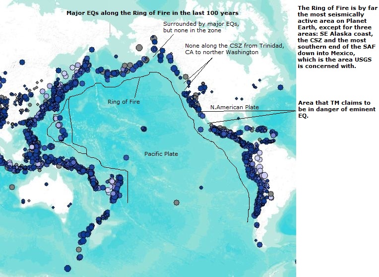
Originally posted by Robin Marks I see nothing unnatural or impeding in California. I'd not be surprised by a Cascadian megaquake. We all know this is a real possibility.
Robin, I think the map below is the reason USGS is paying so much attention to the CA/Mexico border. But I agree, Cascadia and Madrid are the real concerns as far as I can see in the near term.
not good. must stop any way we can. When you include the sonar testing they do which adds pressure as well, and all the weight from cities, roads, resevoirs etc etc. not good
I wrote something the other day on the Arkansas thread. I went a bit over the top. The problem is that I meant every word of it. I went nuts when I discovered the fact that Texas has 53 000 injection wells. That's not including the fracking wells.
reply to post by Glinda
Thanks Glinda. Yep, another bottleneck EQ. Thats what I call them. And that one was pretty much where I and others think the break will occur. Maybe a bit closer to shore. Either way that would be plenty of room to generate a tsunami, and that area, and all of the Mendocino Triple Junction has been hit heavily with Sonar testing by both scientists as well as the Navy recently, who want to use the area for war games and bomb testing. How stupid is that. Stupid people doing stupid things with our money. Urrrrrr.
I think a slow slip is about to happen in the southern CSZ. Ill keep everyone posted.
edit on 6-10-2011 by zworld because: (no reason
given)
reply to post by MamaJ
Will do MamaJ.
In a couple days when I get some time Im going to post about MH and how an oceanic landslide caused by it following the Japan EQ may have been partly responsible for the height of the tsunami.
Will do MamaJ.
In a couple days when I get some time Im going to post about MH and how an oceanic landslide caused by it following the Japan EQ may have been partly responsible for the height of the tsunami.
reply to post by Robin Marks
I don't know how to make it any clearer than this. A disaster in the midwest is coming. And it will be manmade.
Robin,
I believe you!!!! I ONLY became interested in EQ's when Arkansas began its swarm last year and all the fish and birds were dying. This started a snowball effect and the outcome will not be good!
Originally posted by zworld
reply to post by MamaJ
Will do MamaJ.
In a couple days when I get some time Im going to post about MH and how an oceanic landslide caused by it following the Japan EQ may have been partly responsible for the height of the tsunami.
Thank you..I look forward to it.
My two studies in relation to geology are now Magnetite and Methane. They both seem to be players imo but I have not linked them just yet. I have a lot of tabs open to read but have not had more than a few minutes at a time to really read and study.
I'm quite suprised to find that no one else has jumped all over this new article. especially our friend TM:
Upside-down mountain revealed inside Earth
Guess what area was used in this study. Uh-huh. Guess what lake was a focus of discussion. Uh-huh.
Perhaps it is just a coincidence.....
Upside-down mountain revealed inside Earth
Guess what area was used in this study. Uh-huh. Guess what lake was a focus of discussion. Uh-huh.
Scientists on Thursday unveiled the most detailed portrait yet of a mysterious region of the planet that human eyes have never seen, and likely never will — the bottom of Earth's tectonic plates.
The work revealed that beneath a 46,000-square-mile (120,000-square-kilometer) region of Southern California, the continental plate is riddled with abrupt jumps in thickness, changing by as much as 18 miles (30 km) over a relatively short distance.
"It surprised us," Lekic told OurAmazingPlanet. "You could probably drive in less than an hour from the part that's very thick to the part that’s very thin. That means that the topography is very steep."
That's one reason the work focused on Southern California, which is an area of active continental rifting — the millions of years-long process that tears land masses apart. (In addition, the region is crowded with sensors maintained by the state itself, and was also the host for several years to a federally operated network of traveling seismometers known as the USArray.)
The scientists were specifically interested in an area known as the Salton Trough, a region just north of the Gulf of California — a long, narrow body of water the local rifting created when the Baja Peninsula was severed from the North American mainland millions of years ago.
It was directly beneath this rifting region that the lithosphere got so thin, Lekic said.
Perhaps it is just a coincidence.....
reply to post by westcoast
They just announced this but
I wonder for how long they have
know the topography was like
this. Now we group this together
with the information brought
fourth by Middlebrook and its
definitely something to give
good thought to. As of right
now I don't feel its a coincidence
but I may feel different about
that by tomorrow.
Wow,WC!
I saw this earlier today,but I was "occupied"
Here is something else I came across.
www.physorg.com...
I saw this earlier today,but I was "occupied"
Here is something else I came across.
The geologic forces that shape the Earth's surface do their work in the lithosphere, often out of sight and far below the surface. Researchers have now measured the lithosphere’s thickness in southern California. It varies widely, from less than 25 miles to nearly 60 miles. Credit: Fischer Lab, Brown University Rifting is one of the fundamental geological forces that have shaped our planet. Were it not for the stretching of continents and the oceans that filled those newly created basins, Earth would be a far different place. Yet because rifting involves areas deep below the Earth's surface, scientists have been unable to understand fully how it occurs.
www.physorg.com...
So why don't we have a series of solar reflectors and magnifying lenses going from the sun to earth to power a huge grid of electromagnets around the
earth so we can control our own magnetic fields and prevent earthquakes all together? We could probably also use it to blast unwanted asteroids etc
that might collide with earth. Then we wouldn't have to worry about TM's large seismic event even occuring or nuclear power plants falling off into
the ocean. Maybe we could also set up a bunch of tesla coils around earth to absorb unwanted geomagnetic storms.. Earth Quake Predictions,
Hell I want Earthquake Prevention! lol
(Oh we could also use it to move the planet(s), moon etc... or installed on mars we could bring it into a different orbit...)
(Oh we could also use it to move the planet(s), moon etc... or installed on mars we could bring it into a different orbit...)
edit on
7-10-2011 by CaptainKostr because: (no reason given)
Magnitude
4.0
Date-Time
Friday, October 07, 2011 at 22:10:10 UTC
Friday, October 07, 2011 at 03:10:10 PM at epicenter
Location
36.915°N, 117.514°W
Depth
0 km (~0 mile) (poorly constrained)
Region
CENTRAL CALIFORNIA
Distances
20 km (13 miles) SW (230°) from Scottys Castle, CA
49 km (30 miles) SSW (208°) from Tokop, NV
57 km (35 miles) SSE (161°) from Sylvania, NV
62 km (38 miles) NE (53°) from Lone Pine, CA
84 km (52 miles) NNE (31°) from Olancha, CA
220 km (137 miles) WNW (292°) from Las Vegas, NV
Location Uncertainty
horizontal +/- 1.8 km (1.1 miles); depth +/- 4.5 km (2.8 miles)
Parameters
Nph= 17, Dmin=16 km, Rmss=0.48 sec, Gp=130°,
M-type=local magnitude (ML), Version=1
Source
California Integrated Seismic Net:
USGS Caltech CGS UCB UCSD UNR
Event ID
ci15060508
earthquake.usgs.gov...
new topics
-
The Baloney aka BS Detection Kit
Social Issues and Civil Unrest: 1 hours ago -
Suspected Iranian agent working for Pentagon while U.S. coordinated defense of Israel
US Political Madness: 1 hours ago -
How does my computer know
Education and Media: 4 hours ago -
USO 10 miles west of caladesi island, Clearwater beach Florida
Aliens and UFOs: 8 hours ago
top topics
-
Israel ufo shoot down drones?
Aliens and UFOs: 17 hours ago, 6 flags -
USO 10 miles west of caladesi island, Clearwater beach Florida
Aliens and UFOs: 8 hours ago, 6 flags -
Abortions in first 12 weeks should be legalised in Germany, commission says
Medical Issues & Conspiracies: 17 hours ago, 5 flags -
Suspected Iranian agent working for Pentagon while U.S. coordinated defense of Israel
US Political Madness: 1 hours ago, 3 flags -
How does my computer know
Education and Media: 4 hours ago, 1 flags -
The Baloney aka BS Detection Kit
Social Issues and Civil Unrest: 1 hours ago, 1 flags
active topics
-
Suspected Iranian agent working for Pentagon while U.S. coordinated defense of Israel
US Political Madness • 2 • : ImagoDei -
It has begun... Iran begins attack on Israel, launches tons of drones towards the country
World War Three • 627 • : ImagoDei -
How does my computer know
Education and Media • 6 • : andy06shake -
Are the 'Abrahamic Religions' all Really the Worshipping the Same Abrahamic God?
Conspiracies in Religions • 173 • : FlyersFan -
The Acronym Game .. Pt.3
General Chit Chat • 7712 • : bally001 -
Candidate TRUMP Now Has Crazy Judge JUAN MERCHAN After Him - The Stormy Daniels Hush-Money Case.
Political Conspiracies • 188 • : Threadbarer -
The Baloney aka BS Detection Kit
Social Issues and Civil Unrest • 1 • : CosmicFocus -
Negotiations and Diplomacy.
History • 12 • : BrotherKinsMan -
Russia Ukraine Update Thread - part 3
World War Three • 5690 • : F2d5thCavv2 -
End of cash coming to uk soon
Political Issues • 130 • : andy06shake