It looks like you're using an Ad Blocker.
Please white-list or disable AboveTopSecret.com in your ad-blocking tool.
Thank you.
Some features of ATS will be disabled while you continue to use an ad-blocker.

At last, The "Watergate" Of 9/11 :
page: 13share:
Originally posted by LaBTop
By now it is also clear that a 3000 + feet dis-alignment in the FDR certainly did not show up on the cockpit instruments as an alert.
That would have triggered (real-time connected) safety programs to flash red warnings in that cockpit.
Like the EICAS message "UNABLE RNP" that would have been flashed on the cockpit instrument panel, warning the pilots that alignment was out of its allowed wide boundaries (its value expressed in nautical miles ).
ACTUAL navigation performance (ANP) should not exceed RNP (REQUIRED navigation performance).
The FMC triggers the EICAS message UNABLE RNP to alert the flight crew if ANP exceeds RNP.
REQUIRED navigation performance (RNP) values have been created and published for certain areas of operation and procedures. The RNP, expressed in nautical miles, defines the accuracy of the navigation equipment required to fly the route or procedure for which it is published.
ACTUAL navigation performance is also expressed in nautical miles. It represents the radius of a circle centered at the FMC position which defines the limit of the potential error in that position. The smaller the ANP the more accurate the FMC position.
You can find yourself, all of this in Boeing's flight crew training manuals.
In the same thread linked to above, at page 14 (worth reading it all), ATS member "reheat" posted this very logical explanation :
He (Balsamo) obviously believes by showing what appears to be a large position error on the ground at Dulles IAP and then a more accurate position during flight that the IRU was realigned during flight. The equipment in Airline use are not capable of alignment during flight. Some military type units are. Therefore, he's implying there was a substitute aircraft (aircraft swap) at Dulles. It is all poppycock, pure and simple.
I will address the military units as I have considerable experience with them. Weedwhacker will address the Airline units. There is no such thing as auto-align during flight. Military unit capable of alignment in-flight take hours, not minutes to align. Even then they will be miles in error after a long MANAGED alignment procedure. They need very precise updates during this process usually provided by high resolution Attack Radar. It takes considerable time to do this and the results are not very accurate if it will even complete successfully.
AA 77 automatically updated the IRU during flight as it's designed to do becoming more accurate as the flight progressed. By the time the aircraft reached the Pentagon it was in the vicinity of some 200' in error. There is NO WAY in hell that unit was aligned in flight, period. Those in use by the Airlines are not capable and those high quality units in use by the military would not be capable during that period of time and they would not be even close to 200' to the actual position at the end. I hope this helps.
Followed by another "reheat" explanation in another post on the same page :
You still are not understanding an ALIGNMENT versus UPDATES. They are two different things altogether. An alignment occurs on the ground and initializes the unit to a location/position on the surface of the earth. Then accelerometers and gyros detect movement and display that as a position from the original aligned position.
After airborne the units UPDATE their position automatically with either VOR/DME or DME/DME (look up these via google) to control drift and refine the position already present in the units. In other words, the UPDATES cause them to be more precise over time.
Read this: en.wikipedia.org...
If you can recall GPS was not in wide use in 2001. I believe only B-1's and B-2's did have GPS in the aircraft for use in programming precision guided GPS type bombs. I do know of any other aircraft who had GPS at that time. Selective Availability (SA) was removed in 2000, but to my knowledge no airline had GPS in use by 2001. Also, there were no WAAS satellites at that time, so it was not practical for the airlines to spend the huge cost in implementing GPS until WAAS was turned on in 2003.
Read about SA here: en.wikipedia.org...
Read about WAAS here: en.wikipedia.org...
Don't despair. If you still don't understand after this and after reading those articles we'll try again. As Weedwhacker said it's difficult to "dumb down" this stuff for the layman.
The Boeing 757-200/300 Flight Crew Training Manual - RNP and RNAV Operations, provides this explanation nowadays for positional drift and how to correct it :
www.biggles-software.com...
The Biggles software represent the policy of a particular airline (Monarch, in the UK).
The FMC uses its calculated present position to generate lateral steering commands along the active leg to the active waypoint. The FMC requires position data from at least one IRS. All other position sources are validated against the IRS position and increase the accuracy of the FMC position.
FMC Position Update (Basic FMC)
On the ground, the FMC position is based on the IRS position.
Since inertial systems accumulate position errors as a function of time, the position information being used by the FMC is slowly accumulating errors. These position errors can be detected by observing the position of the airplane on the HSI map.
If an extended ground delay occurs and a significant map error is noticed the IRS should be realigned and present position re-entered.
As installed
When the autothrottle is engaged for takeoff, the FMC position is automatically updated to the takeoff runway position displayed on the TAKEOFF REF page.
In flight, the FMC position is continually updated from the navigation radios.
It seems to me, that these procedures were also in use on 9/11, except the GPS possibilities, which were not present in the 9/11 commercially flown planes. And were used after 2003, when the non-military used GPS satellite system was at last in place and operating.
The above full explanation of the difference between an update just after take-off and an align on the ground was posted by me already on page 8.
There come even better posts after that on that page.
But clearly wasted on Rob Balsamo.
This is a speed of 500 miles per hour.
Just a few tenth of M/hr slower as the even higher propagated last seconds end-speed of Flight 77 in the official data :
www.youtube.com...
That plane at that even higher end speed could not have made any turn radius of importance.
Let ever flying with a bank angle of any importance.
The G-forces if it attempted even a small bank, would have shattered its pieces all over the place.
And any witnesses would have seen the same as you see now, whether head-on or sideways watching it.
Thus ALL witnesses describing a slight or reasonable bank attitude of 20 to 30° right bank, must have seen a MUCH slower plane passing them.
And that's where reheat must be wrong, but he keeps believing in that officially published end-speed data.
And that's why he keeps repeating that my proposed speed of 200 knots at a right bank angle of 22° is impossible. But it is not.
It is only impossible when you persistently keep clutching to that ridiculous end-speed of over 500 M/hr.
This video was posted by onesliceshort, still a member at PfT.
He is an intelligent, logical thinking person.
That's why it is so illogical that he still is a member there.
After he saw this thread and his idol again could not resist posting in it.
Chances are small that his stubborn idol will ever admit that he is seriously wrong.
On a side note: I see now in my dictionary that obnoxious means not the same as stubborn.
I meant stubborn when I wrote obnoxious anywhere in this thread. Sorry for that. It bears a much heavier load then the word stubborn, which was not intended.
I meant just "persistently" stubborn.
Not "obnoxiously" stubborn.
edit on 20/11/11 by LaBTop because: Link to YouTube garbled up. Fixed now.
www.abovetopsecret.com...
I have to see if that spot represents a shifted or non-shifted position described by the last seconds of the FDR. We know now that positional data in any FDR are prone to shifting during the whole airborne portion of its flight. But we may assume that in those last seconds, the radar did update the plane's position quite precise compared to the beacons on the very nearby airport.
Why does the data then show such a shift in position which is not logical?
Even the NTSB boys were confused and released an animation with a totally different flight path then the internal damage path of 60.25° combined with the 5 downed light poles should predict.
If you view the NTSB online animation its last 20 seconds, the plane even flew nearly hundred meters NORTH of the Navy Annex.
And believe me, those NTSB investigators knew already for a long time what the flight path should be, when they had to calculate back from all that damage on the Pentagon grounds.
And still they released that seemingly wrong flightpath on the left (north) side of the Annex and the Sheraton Hotel.
Are there so many incompetent researchers at the NTSB, that such a "blatantly wrong" flight path slips through their editor rooms, and gets published as one of the most important parts of one of the main events in modern history?
The plane's position recorded in that FDR, so near to Reagan Int. Airport, must have been updated several times, and thus be within the normal fault error in 2001 of, if I remember correctly, about 100 feet or 30.48 meters. Could be yards, not sure yet.
Is it however?
And why didn't the NTSB take that eventual quite big fault error in consideration in their calculations, and moved the flight path more south, much more south, to fit the already officially published 60.25° path deducted from in- and external damage?
Or did they do that already, and thus arrived at that strange flight path far north of the Annex buildings, which not one witness ever described?
Don't start again with the old "perspective" adagio, the NTSB showed repeating 90° to the vertical flight path, downwards lines, in intervals, to show the plane's position above ground.
Or is the NTSB a bunch of incompetent slaves of some influential politicians and generals?
How on earth could that totally wrong flight path for the last 20 seconds then ever have been published?
Btw, to my knowledge, the NTSB never retracted that under FOIA-pressure released animation......
The Discovery Channel keeps bombarding us worldwide with air disaster investigations, where we can see the same NTSB investigators at work year in, year out.
Painting quite a different picture than an incompetent bunch.
Or does the NTSB not want to give in to those that pressure them to change their figures found from the FDR data, and their conclusions offered in that damming animation?
Honestly said, it looks more and more that the order still stands :
DO NOT REACT !
(Because you can only make the mess "we" made only worse.)
"We" being the unknown factor.
(**)ProudBird : In fact, if you note....the Pentagon Memorial is pictured in that current photo. If you get a chance to visit, you will see that there are lines drawn in the ground, that represent the course of the airplane as it passed directly over that spot. In addition, the width of the Memorial is exactly 124 feet, 10 inches...to represent the wingspan of the Boeing 757.
I have to see if that spot represents a shifted or non-shifted position described by the last seconds of the FDR. We know now that positional data in any FDR are prone to shifting during the whole airborne portion of its flight. But we may assume that in those last seconds, the radar did update the plane's position quite precise compared to the beacons on the very nearby airport.
Why does the data then show such a shift in position which is not logical?
Even the NTSB boys were confused and released an animation with a totally different flight path then the internal damage path of 60.25° combined with the 5 downed light poles should predict.
If you view the NTSB online animation its last 20 seconds, the plane even flew nearly hundred meters NORTH of the Navy Annex.
And believe me, those NTSB investigators knew already for a long time what the flight path should be, when they had to calculate back from all that damage on the Pentagon grounds.
And still they released that seemingly wrong flightpath on the left (north) side of the Annex and the Sheraton Hotel.
Are there so many incompetent researchers at the NTSB, that such a "blatantly wrong" flight path slips through their editor rooms, and gets published as one of the most important parts of one of the main events in modern history?
The plane's position recorded in that FDR, so near to Reagan Int. Airport, must have been updated several times, and thus be within the normal fault error in 2001 of, if I remember correctly, about 100 feet or 30.48 meters. Could be yards, not sure yet.
Is it however?
And why didn't the NTSB take that eventual quite big fault error in consideration in their calculations, and moved the flight path more south, much more south, to fit the already officially published 60.25° path deducted from in- and external damage?
Or did they do that already, and thus arrived at that strange flight path far north of the Annex buildings, which not one witness ever described?
Don't start again with the old "perspective" adagio, the NTSB showed repeating 90° to the vertical flight path, downwards lines, in intervals, to show the plane's position above ground.
Or is the NTSB a bunch of incompetent slaves of some influential politicians and generals?
How on earth could that totally wrong flight path for the last 20 seconds then ever have been published?
Btw, to my knowledge, the NTSB never retracted that under FOIA-pressure released animation......
The Discovery Channel keeps bombarding us worldwide with air disaster investigations, where we can see the same NTSB investigators at work year in, year out.
Painting quite a different picture than an incompetent bunch.
Or does the NTSB not want to give in to those that pressure them to change their figures found from the FDR data, and their conclusions offered in that damming animation?
Honestly said, it looks more and more that the order still stands :
DO NOT REACT !
(Because you can only make the mess "we" made only worse.)
"We" being the unknown factor.
reply to post by LaBTop
This is an untrue statement:
Please refer to this calculator, used to show the various g-load relationships based on bank angle (the g-load is completely dependent on angle of bank only. Let me repeat that: The g-load is completely dependent on angle of bank only).
The airspeed affects the radius of turn...for any fixed angle of bank.
Use this calculator, and enter any airspeed value you wish, then look at the resulting "G Load" figure
(The stall speed data input box is irrelevant to this demonstration)
This is an untrue statement:
The G-forces if it attempted even a small bank, would have shattered its pieces all over the place.
Please refer to this calculator, used to show the various g-load relationships based on bank angle (the g-load is completely dependent on angle of bank only. Let me repeat that: The g-load is completely dependent on angle of bank only).
The airspeed affects the radius of turn...for any fixed angle of bank.
Use this calculator, and enter any airspeed value you wish, then look at the resulting "G Load" figure
(The stall speed data input box is irrelevant to this demonstration)
You're right.
EDIT : and this post of yours is why:
www.abovetopsecret.com...
ENDEDIT.
Any comments on the rest of the other 5000+ characters?
Enter 434.5 KNOTS as the speed (500 MPH), 180 MPH as the rated stall speed of a 757, and a 22° bank angle.
Enter 200 KNOTS as the speed (230.2 MPH) and the same two other inputs.
Quite a different radius, ain't it so?
41,548.3 feet at 500 MPH. (This one will only fit one witness position all the time, all you try)
8,806.9 feet at 230.2 MPH. (this one fits all 5 witness positions I used)
Btw, I used the exact same calculator from the beginning of this thread.
edit on 20/11/11 by LaBTop because: (no reason given)
reply to post by LaBTop
Sorry, but none of what you just wrote there is relevant. The airspeed/bank angle/radius of turn overly analyzed examinations are not pertinent. It is applicable to the first large, wide descending turn if you wish to check out the physical parameters and relationships there.
But, the jet never flew "north" of the "citgo", so all the rest is just spinning of wheels useless.
edit on Sun 20 November 2011 by ProudBird because: (no reason given)
Originally posted by ProudBird
But, the jet never flew "north" of the "citgo", so all the rest is just spinning of wheels useless.
Of course it didn't. There is an abundance of evidence for the flight path and subsequent impact with the building.. Hard evidence, not someones perception of what happened.
1) Three different radars and the 84 RADES data show the returns to just about the east side of the Navy Annex. (It would be impossible aerodynamically to go North of the service station from there.
2) Truthers are always harping about the lack of video, but the Tribby Video vividly shows the C-130, which followed AA 77's path on it's approach. Because of the position of the C-130 and the plume of smoke there is NO DOUBT at all of it's position.
3) Lamp posts, damaged tree, and a damaged camera pole agree with the known path...
4) FDR found in the building supports all of the above.
5) Building Performance report agrees with all of the above evidence.
6) Testimony of the recovery efforts of first responders and the clean up crew outlined in "Firefight to save the Pentagon" agrees with the above.
7) Recovered DNA and personal affects of passengers and crew found inside the building.
I probably left something out, but this is enough to prove where the aircraft flew and where it ended up. To argue otherwise without proving *all* of the above either untrue or fraudulent is an exercise in futility. It is not simply stupid to argue otherwise, it is stupid in the extreme...
reply to post by ProudBird
Pretty sloppy guys there at the NTSB then, ain't it so?
This is the full version of the NTSB animation of AA Flight 77 hitting the Pentagon on 9/11/2001, obtained via FOIA request :
www.youtube.com...
At the 1:21:30 mark in this full Flight 77 NTSB video (13:37:05 EDT) the speed is 302 KTS, altitude is 2268 FT and the heading meter in the right bottom starts slowly counting up from 59 to 60 and then in the next 30 seconds moves up to 70, then stays steadily on 70 up till the end of the animation.
The rudder position stays steadily in the zero position, all that time.
I also see that the plane is drifting, since I see it is projected on the flight path its white line with its nose positioned to the left of that flight path, and its tail to the right of it.
The two thrust indicators in the left bottom show the 50% thrust position, but not exactly the same, the Left thrust seems a tiny bit lower, which probably is an indication of a tad bit more thrust on the right jet engine, thus compensating for the NNW winds on 9/11, and thus the drifted position on the white flight path line. At 13:37:09 the thrust levers are shifted towards the 100% thrust position in the next 7 seconds (up to 13:37:16). The speed shows 312 KTS then. And the heading 066°.
I thought the official heading was 60.25°, all the way from along the SOUTH side of the then eight Navy Annex buildings up to the point of impact.
And an awfull lot of witnesses talked about a 20 to 30° right bank flown by the plane.
Nothing to see of that in these last 20 seconds.....
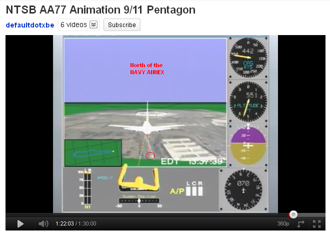
Here the meter shows 070°, while it is flying from 900 FT high on the NORTH side of the Navy Annex, up to a few seconds before impact.
From 13:37:35 up to 13:37:44 EDT where the animation stops, but the plane is still hundreds of meters away from the west wall impact point.
At 462 KTS speed, 180 FT altitude and 070° heading. And all those last 9 seconds not any influence by that coming from the NNW wind, on a 2 engines at 100% thrust flying plane, it kept flying on a steady 070° course. No drifting expressed in a resulting eventual 1° or more change in heading.
But the plane still shows a small drift position in this animation, even after both jet engines are pushing the plane with the exact same full power each, so to see.
At 13:37:41and :42 the plane is shown on the north side of the CITGO station, 325 to 307 feet high in the air, at 452 KTS and at a steady 070° heading.
This all according to the read-out obtained by the NTSB from the FBI, and shown in this full NTSB animation.
Warren Stutt decoded 4 more seconds (every next second in it, more parts of the data in it, were garbled up) from the FOIA released NTSB data.
Which they obtained from the FDR found by the FBI and which they kept in posession for quite some time, before handing it over to the NTSB. And there and then, the falsification of those last seconds could have taken place. By one person, accessed with the right papers.
Why else does the NTSB publish totally wrong figures, not fitting any witness accounts?
Yes, reheat, I see your only defence coming : they did not position the ground map in a right manner under the flight path.
Question : The same NTSB professionals that do this all their lifes? Suddenly shifting the most important map in their careers for their first 9/11 FOIA request release, a few hundred meters to the right (south). Really?
Pretty sloppy guys there at the NTSB then, ain't it so?
This is the full version of the NTSB animation of AA Flight 77 hitting the Pentagon on 9/11/2001, obtained via FOIA request :
www.youtube.com...
At the 1:21:30 mark in this full Flight 77 NTSB video (13:37:05 EDT) the speed is 302 KTS, altitude is 2268 FT and the heading meter in the right bottom starts slowly counting up from 59 to 60 and then in the next 30 seconds moves up to 70, then stays steadily on 70 up till the end of the animation.
The rudder position stays steadily in the zero position, all that time.
I also see that the plane is drifting, since I see it is projected on the flight path its white line with its nose positioned to the left of that flight path, and its tail to the right of it.
The two thrust indicators in the left bottom show the 50% thrust position, but not exactly the same, the Left thrust seems a tiny bit lower, which probably is an indication of a tad bit more thrust on the right jet engine, thus compensating for the NNW winds on 9/11, and thus the drifted position on the white flight path line. At 13:37:09 the thrust levers are shifted towards the 100% thrust position in the next 7 seconds (up to 13:37:16). The speed shows 312 KTS then. And the heading 066°.
I thought the official heading was 60.25°, all the way from along the SOUTH side of the then eight Navy Annex buildings up to the point of impact.
And an awfull lot of witnesses talked about a 20 to 30° right bank flown by the plane.
Nothing to see of that in these last 20 seconds.....
Here the meter shows 070°, while it is flying from 900 FT high on the NORTH side of the Navy Annex, up to a few seconds before impact.
From 13:37:35 up to 13:37:44 EDT where the animation stops, but the plane is still hundreds of meters away from the west wall impact point.
At 462 KTS speed, 180 FT altitude and 070° heading. And all those last 9 seconds not any influence by that coming from the NNW wind, on a 2 engines at 100% thrust flying plane, it kept flying on a steady 070° course. No drifting expressed in a resulting eventual 1° or more change in heading.
But the plane still shows a small drift position in this animation, even after both jet engines are pushing the plane with the exact same full power each, so to see.
At 13:37:41and :42 the plane is shown on the north side of the CITGO station, 325 to 307 feet high in the air, at 452 KTS and at a steady 070° heading.
This all according to the read-out obtained by the NTSB from the FBI, and shown in this full NTSB animation.
Warren Stutt decoded 4 more seconds (every next second in it, more parts of the data in it, were garbled up) from the FOIA released NTSB data.
Which they obtained from the FDR found by the FBI and which they kept in posession for quite some time, before handing it over to the NTSB. And there and then, the falsification of those last seconds could have taken place. By one person, accessed with the right papers.
Why else does the NTSB publish totally wrong figures, not fitting any witness accounts?
Yes, reheat, I see your only defence coming : they did not position the ground map in a right manner under the flight path.
Question : The same NTSB professionals that do this all their lifes? Suddenly shifting the most important map in their careers for their first 9/11 FOIA request release, a few hundred meters to the right (south). Really?
edit on 20/11/11 by LaBTop because: (no reason given)
reply to post by LaBTop
The rate of change in heading is entirely due to the angle of bank. (This relates to the bank angle calculator linked earlier). Steeper angles of bank, more rapid rate of turn.
I saw a heading of 069° for a while, before the last seconds of 070°. I also saw the pilot "jinking" the controls a bit, abruptly, as he continued to refine his aim at the "target". It immediately shows how those screaming "It was too precise" don't know what they're talking about. Remember that "aiming" an airplane is rather intuitive to even a fairly new pilot.....the concept of the visual relationship of a "spot" in the windshield and how it moves is the cue used to judge your "aim". It is basic to being able to land, which of course is learned very early on...in just the first few hours of learning.
That is normal. Perhaps you might be mistaking the purpose of the airplane rudder, and thinking of it more like a ship's rudder, in the water? Then rudder is little used, and is not the primary control that causes the change of heading, for an airplane. It is the actual bank, to either side of vertical, that creates the turn. In all airplanes, the rudder will correct for adverse yaw....and in small airplanes, adverse yaw is a situation that occurs due to the aerodynamics of the ailerons themselves. The downward-moving aileron, out near the wingtip, causes a bit of excess drag, which imparts a yaw in that direction.
Say you are banking to the left. The right-hand aileron deflects downward....but, it causes a slight yaw, then, to the right...opposite the intended turn direction. Rudder is used to offset this tiny yaw input, and thus it is called making a "coordinated" turn. The reverse is required, to "roll out" of the turn back to level.
Note that even in a steady bank angle turn, the ailerons are also neutralized to the center position.
On large jets like the 757, a "yaw damper" is in action, at all times, and works automatically....so that when a pilot uses ailerons to any extent, the rudder automatically keeps the turn "coordinated". HOWEVER, also in a large modern jet, for the majority of high-airspeed roll control, the ailerons are not the primary flight control to achieve it....the Flight Spoilers do most of that work. With Spoilers, there is NO adverse yaw whatsoever.
Here is a graphic depicting a Boeing 767 and all of its Flight Controls:
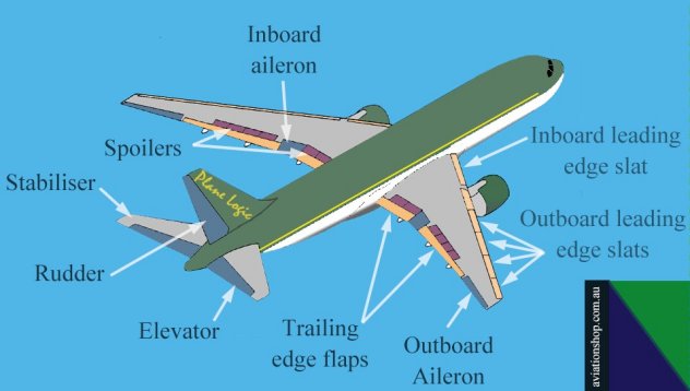
(Note, the 757 does not have Inboard Ailerons, unlike the 767)
I think that is a misinterpretation of the NTSB animation graphic depiction. I (think) the yellow lines tracing the track of the airplane are representing the IRU position triple-mix as recorded by the FDR. The occasional vertical yellow lines represent the points of reference, and the horizontal yellow line the average blend to connect those data points smoothly. They are there to provide the viewer a 3-D reference in a 2-D video.
No....all that shows is the engine N1 RPM...in percentages, which is how the engine instruments are labelled. It has nothing to due with "wind correction" at all. In most jets, when the two (or three, or four) thrust levers are physically aligned, the engines do not always match perfectly also. We get used to this. And, in this case, the slight power mis-match is insignificant. Yes, he pushed the thrust up to the forward stops at the end, to get the most speed possible.
Is that referenced to True, or to Magnetic North??
Doubtful. I saw at most, ten degrees on the last few seconds.
At the 1:21:30 mark in this full Flight 77 NTSB video (13:37:05 EDT) the speed is 302 KTS, altitude is 2268 FT and the heading meter in the right bottom starts slowly counting up from 59 to 60 and then in the next 30 seconds moves up to 70, then stays steadily on 70 up till the end of the animation.
The rate of change in heading is entirely due to the angle of bank. (This relates to the bank angle calculator linked earlier). Steeper angles of bank, more rapid rate of turn.
I saw a heading of 069° for a while, before the last seconds of 070°. I also saw the pilot "jinking" the controls a bit, abruptly, as he continued to refine his aim at the "target". It immediately shows how those screaming "It was too precise" don't know what they're talking about. Remember that "aiming" an airplane is rather intuitive to even a fairly new pilot.....the concept of the visual relationship of a "spot" in the windshield and how it moves is the cue used to judge your "aim". It is basic to being able to land, which of course is learned very early on...in just the first few hours of learning.
The rudder position stays steadily in the zero position, all that time.
That is normal. Perhaps you might be mistaking the purpose of the airplane rudder, and thinking of it more like a ship's rudder, in the water? Then rudder is little used, and is not the primary control that causes the change of heading, for an airplane. It is the actual bank, to either side of vertical, that creates the turn. In all airplanes, the rudder will correct for adverse yaw....and in small airplanes, adverse yaw is a situation that occurs due to the aerodynamics of the ailerons themselves. The downward-moving aileron, out near the wingtip, causes a bit of excess drag, which imparts a yaw in that direction.
Say you are banking to the left. The right-hand aileron deflects downward....but, it causes a slight yaw, then, to the right...opposite the intended turn direction. Rudder is used to offset this tiny yaw input, and thus it is called making a "coordinated" turn. The reverse is required, to "roll out" of the turn back to level.
Note that even in a steady bank angle turn, the ailerons are also neutralized to the center position.
On large jets like the 757, a "yaw damper" is in action, at all times, and works automatically....so that when a pilot uses ailerons to any extent, the rudder automatically keeps the turn "coordinated". HOWEVER, also in a large modern jet, for the majority of high-airspeed roll control, the ailerons are not the primary flight control to achieve it....the Flight Spoilers do most of that work. With Spoilers, there is NO adverse yaw whatsoever.
Here is a graphic depicting a Boeing 767 and all of its Flight Controls:
(Note, the 757 does not have Inboard Ailerons, unlike the 767)
I also see that the plane is drifting, since I see it is projected on the flight path its white line with its nose positioned to the left of that flight path, and its tail to the right of it.
I think that is a misinterpretation of the NTSB animation graphic depiction. I (think) the yellow lines tracing the track of the airplane are representing the IRU position triple-mix as recorded by the FDR. The occasional vertical yellow lines represent the points of reference, and the horizontal yellow line the average blend to connect those data points smoothly. They are there to provide the viewer a 3-D reference in a 2-D video.
The two thrust indicators in the left bottom show the 50% thrust position, but not exactly the same, the Left thrust seems a tiny bit lower, which probably is an indication of a tad bit more thrust on the right jet engine, thus compensating for the NNW winds on 9/11, and thus the drifted position on the white flight path line. At 13:37:09 the thrust levers are shifted towards the 100% thrust position in the next 7 seconds (up to 13:37:16).
No....all that shows is the engine N1 RPM...in percentages, which is how the engine instruments are labelled. It has nothing to due with "wind correction" at all. In most jets, when the two (or three, or four) thrust levers are physically aligned, the engines do not always match perfectly also. We get used to this. And, in this case, the slight power mis-match is insignificant. Yes, he pushed the thrust up to the forward stops at the end, to get the most speed possible.
I thought the official heading was 60.25°, all the way from along the SOUTH side of the then eight Navy Annex buildings up to the point of impact.
Is that referenced to True, or to Magnetic North??
And an awfull lot of witnesses talked about a 20 to 30° right bank flown by the plane.
Doubtful. I saw at most, ten degrees on the last few seconds.
ProudBird, I thought is was 60.25° true north, it is printed in one of the maps I posted in this thread, but check it out please, because that could
be quite important, since there is quite a difference between magnetic and true north.
Then 070° could perhaps be 60.25° true north?
Could you give the right factor to insert in the calculation for transforming true north heading into magnetic north heading?
Thank you also, ProudBird for the time you took to give your pilot perspective in the above post.
In accordance to that, this is a good opportunity to insert a lengthy private message that "weedwhacker" send me in August this year, regarding this thread.
This is the opportunity to thank him for that extensive help.
It is very important in my opinion, to insert as much professional pilot views as possible in threads like this, so later historical truth researchers have as much general and specific information at hand, when perhaps new techniques can be used to obtain the indisputable real true story of the day of 9/11.
Let's hope this board will still exist then, to fall back on. So many boards where I posted valuable information are gone, washed away for so many clear but also shady reasons.
Werther it will be the official story, or any other corrected one, let's hope the real historical truth will survive.
Because we must never forget, that technical progress features like f.ex. the extensive use of the GPS system, was not used in 2001 like we are used to it, nowadays.
And so are many more technical details quite different for planes flown now, ten years later, then in those flown back in 2001.
Many new discussion participants make the same mistake, they look at our years long discussions with the know-how of the present time.
But airports change in lay-out; control towers have been displaced and rebuild, taxi lanes and resting and parking areas have been added. Airplanes are fitted with many new features, pilot and flight controller instructions are modernized.
Our world changes with an increasingly rapid pace.
Next post is weedwhacker's August 2011 explanation to me, which fits in this thread perfectly :
Your "Watergate" thread....
from: weedwhacker
sent: 20/8/11 at 07:05
My initial PM, here, was to inform you of your misconceptions and mis-assumptions, evident in your OP (As, this so-called *anomaly* has been addressed, already on ATS...last year sometime, don't recall the thread any more....might be the one started by a P4T lackey, or even Balsamo himself, using one of his several dozen sock-puppet names, here).
However, I stumbled upon your post:
www.abovetopsecret.com...
SO, now only a few things to clear up for you. Good to see, you now understand the workings of the pre-GPS-update IRS units? (Also covered in the aforementioned thread, by yours truly).
OK, then....this bit is a breath of fresh air:
After all that work; and what might possibly have set an ATS record for the single longest *one-page* opening post of all time. All for naught, innit??
Anyway....moving on. There's this next bit:
Nope. Also covered, in great detail, in various threads over the years.
Firstly, recall that the entire meme of the "NoC" so-called *theory* stems from one, and only one source, initially....the atrocious "investigate team" that call themselves the "CIT"....and, Craig Ranke and his sidekick, whatshisname....
I noticed that their sad reputation for "truth and honesty" was pointed out, somewhere on the first day of your thread, along with the shenanigans of Bobby B at P4T.
So.....rather than type out words, at length....HERE is a video that I found at YouTube, and the fellow who made it clears up the misunderstanding, and how the perspective of those very, very few "NoC witnesses" has been misconstrued, and used as fodder for personal aggrandizement, by Ranke:
www.youtube.com...
So, your (sorry) rather silly hypothesis of "planted explosives", and all the rest written in the above post, is simply rubbish.
Finally....whole other topic, but the issue of UAL 93 is very, very obvious to ANY airline pilot with even a modicum of experience and knowledge. Even more so, to those of us with actual hands-on experience in the airplane.
Here, I have found a Google Video that shows the FULL-length NTSB animation produced from the UAL 93 SSFDR. (Minus all the nonsense included in so many, on YouTube...that have sprouted from...you guessed it!! Balsamo, and P4T. He is quite delusional, it's rather sad, really).
Of course, you may F/F to the end, but it is there, in its entirety, nonetheless.....all 84 minutes:
video.google.com...
(Please, note the ATC recording, these from the ARTCC facility tapes, not from the CVR. This is the time of the hijacking itself, and the cockpit intrusion. You will also, in research, find that not at ANY time was any fighter jet on any ATC frequency, and recorded being vectored near enough to UAL 93 to effectuate a shoot-down. Such an event, if it occurred, would have been recorded, even if the fighter only used UHF radio, you would still hear the controller speaking....it's common when they talk on UHF to the military, you hear them on VHF too as they transmit simultaneously on two frequencies).
Everything on the ATC recording is completely real, and exactly how such an event (losing ground-to-air voice comm with the airplane) would sound, and would be handled, in the initial confusion. I can't emphasize enough, my years of experience can discern reality from anything that was "staged" or "scripted".
Furthermore....you may also access the NTSB report, titled:
I have the PDF on my HD....you may Google for links. Of course, you can also compare to any FDR info you may also have, to convince yourself that they all corroborate.
Once you find the NTSB written report above, note a few things that pilots can understand, based on what is presented....also, compare to the video. I hope you can interpret what it shows....besides the four primary flight instruments depicted, looking at the control wheel (which represents the actual movement of the flight controls, via the manipulation of the cockpit controls), on the left are the engine power settings (N1), and to the right labelled "A/P", is the autopilot on/off status. Three A/Ps, Left, Center and Right. Below the control wheel, the rudder position indicator.
At time hack 17:30.....note the Center A/P is selected *On*. You can also verify that in the printed NTSB report. On a nice day, like the morning of the 11th September, it is not uncommon to hand-fly the airplane in that way. Many of us enjoy the simple pleasure of doing so. The initial level-off @FL280 was, IIRC, due to conflicting crossing traffic above them....so, just to alleviate the need for continued attention to maintaining level flight, at altitude, the Flying Pilot elected to engage the A/P, from then on.
The SOP at most companies, on the B757/767, was/is simple....if Captain is 'Flying Pilot' (or, 'Pilot Flying'....semantics vary at different airlines), he/she uses the Left A/P, and if it's the First Officer's leg, then s/he uses the Right. That would have told me, easily, who was flying that leg (**)....but, at United, they also liked to utilize the Center A/P occasionally, and it's purely just a procedure and a choice....(a way to "exercise" all the components associated with the Center system)......there is sometimes a "rule of thumb", such as, if it's an odd-numbered day, and you're Westbound....or, an odd-numbered day and an odd-flight number, etc. Just whatever the airline Flight Operations Dept. determines to be the *norm* for that fleet equipment. There are dozens of such little details and non-regulation SOPs, that vary by airline and airplane type. Merely for operational reasons.
((**) I'm sure the ATC recordings have been used to identify the pilot who was not flying, since he would be the one doing all the radio work. That's how duties are divided, in the crew concept environment. IIRC, the F/O was flying that morning, but don't quote me on that, I have to look it up to be certain).
SO.....all of that, rather long-winded (worded) explanation, was needed to describe what I and other real pilots, know intuitively, from experience. The data is real-life, from the FDR. No doubt about it. It is the sort of subtle detail that would not be noticed by amateurs, or armchair researchers.....
.....and, of course, it is but one example that ties everything together, to an experienced eye.
That same written "autopilot activity", etc, NTSB report can be used to compare to AAL 77's info, too.....I'm pretty sure David Charlesbois, the F/O, was flying that one.....he hand-flew up to about 15,000 or 16,000 feet before engaging the right-hand A/P. (In the USA 18,000 is the "transition level" from "local" barometric to the Flight Level regime. Altimeters are re-set, and it's a psychological transition as well, in mind-set....all flights above FL180 are positive control on IFR flight plans with ATC, so there's less need to be wary of unknown VFR traffic and the very rare mid-air collision potential).
Transition altitudes/levels in other nations vary, it's mostly due to the highest terrain point, in the country. Flying internationally requires additional knowledge and awareness of these differences. In the UK, for example, transition altitude (climbing) and transition level (descending) is between 5,000 and 6,000 feet. (Depends on prevailing barometric pressure....when extremely low, the *bottom* or "normally" lowest flight level is unusable). Different than the USA, since there are no tall mountains in Great Britain....[smile]
(I presume you live in the UK?)
You can see, on this Heathrow STAR ("Standard Terminal ARrival") chart, the note in the upper left corner. No one is expected to memorize the different values, everywhere they fly, so it's published handily on the charts:
www.ead.eurocontrol.int.
NATS London Heathrow (EGLL) Source
from: weedwhacker
sent: 20/8/11 at 07:05
My initial PM, here, was to inform you of your misconceptions and mis-assumptions, evident in your OP (As, this so-called *anomaly* has been addressed, already on ATS...last year sometime, don't recall the thread any more....might be the one started by a P4T lackey, or even Balsamo himself, using one of his several dozen sock-puppet names, here).
However, I stumbled upon your post:
www.abovetopsecret.com...
SO, now only a few things to clear up for you. Good to see, you now understand the workings of the pre-GPS-update IRS units? (Also covered in the aforementioned thread, by yours truly).
OK, then....this bit is a breath of fresh air:
Forget alternate planes, I just proved to myself, that against everything I believed up till this day, there was simply the same plane as ever that took off from Dulles at its normal departure time.
Flight 77, spotted by ground personnel at it's usual Gate D26.
At last we can say that the FDR handed over by the NTSB depicts at least the right departure gate.
After all that work; and what might possibly have set an ATS record for the single longest *one-page* opening post of all time. All for naught, innit??
Anyway....moving on. There's this next bit:
We still have all the NoC witnesses, and according to P49/11T, that same FDR does not depict a NoC flight path.
Nope. Also covered, in great detail, in various threads over the years.
Firstly, recall that the entire meme of the "NoC" so-called *theory* stems from one, and only one source, initially....the atrocious "investigate team" that call themselves the "CIT"....and, Craig Ranke and his sidekick, whatshisname....
I noticed that their sad reputation for "truth and honesty" was pointed out, somewhere on the first day of your thread, along with the shenanigans of Bobby B at P4T.
So.....rather than type out words, at length....HERE is a video that I found at YouTube, and the fellow who made it clears up the misunderstanding, and how the perspective of those very, very few "NoC witnesses" has been misconstrued, and used as fodder for personal aggrandizement, by Ranke:
www.youtube.com...
So, your (sorry) rather silly hypothesis of "planted explosives", and all the rest written in the above post, is simply rubbish.
Finally....whole other topic, but the issue of UAL 93 is very, very obvious to ANY airline pilot with even a modicum of experience and knowledge. Even more so, to those of us with actual hands-on experience in the airplane.
Here, I have found a Google Video that shows the FULL-length NTSB animation produced from the UAL 93 SSFDR. (Minus all the nonsense included in so many, on YouTube...that have sprouted from...you guessed it!! Balsamo, and P4T. He is quite delusional, it's rather sad, really).
Of course, you may F/F to the end, but it is there, in its entirety, nonetheless.....all 84 minutes:
video.google.com...
(Please, note the ATC recording, these from the ARTCC facility tapes, not from the CVR. This is the time of the hijacking itself, and the cockpit intrusion. You will also, in research, find that not at ANY time was any fighter jet on any ATC frequency, and recorded being vectored near enough to UAL 93 to effectuate a shoot-down. Such an event, if it occurred, would have been recorded, even if the fighter only used UHF radio, you would still hear the controller speaking....it's common when they talk on UHF to the military, you hear them on VHF too as they transmit simultaneously on two frequencies).
Everything on the ATC recording is completely real, and exactly how such an event (losing ground-to-air voice comm with the airplane) would sound, and would be handled, in the initial confusion. I can't emphasize enough, my years of experience can discern reality from anything that was "staged" or "scripted".
Furthermore....you may also access the NTSB report, titled:
"Study of Autopilot, Navigation Equipment, and Fuel Consumption Activity
Based on United Airlines Flight 93 and American Airlines Flight 77
Digital Flight Data Recorder Information"
I have the PDF on my HD....you may Google for links. Of course, you can also compare to any FDR info you may also have, to convince yourself that they all corroborate.
Once you find the NTSB written report above, note a few things that pilots can understand, based on what is presented....also, compare to the video. I hope you can interpret what it shows....besides the four primary flight instruments depicted, looking at the control wheel (which represents the actual movement of the flight controls, via the manipulation of the cockpit controls), on the left are the engine power settings (N1), and to the right labelled "A/P", is the autopilot on/off status. Three A/Ps, Left, Center and Right. Below the control wheel, the rudder position indicator.
At time hack 17:30.....note the Center A/P is selected *On*. You can also verify that in the printed NTSB report. On a nice day, like the morning of the 11th September, it is not uncommon to hand-fly the airplane in that way. Many of us enjoy the simple pleasure of doing so. The initial level-off @FL280 was, IIRC, due to conflicting crossing traffic above them....so, just to alleviate the need for continued attention to maintaining level flight, at altitude, the Flying Pilot elected to engage the A/P, from then on.
The SOP at most companies, on the B757/767, was/is simple....if Captain is 'Flying Pilot' (or, 'Pilot Flying'....semantics vary at different airlines), he/she uses the Left A/P, and if it's the First Officer's leg, then s/he uses the Right. That would have told me, easily, who was flying that leg (**)....but, at United, they also liked to utilize the Center A/P occasionally, and it's purely just a procedure and a choice....(a way to "exercise" all the components associated with the Center system)......there is sometimes a "rule of thumb", such as, if it's an odd-numbered day, and you're Westbound....or, an odd-numbered day and an odd-flight number, etc. Just whatever the airline Flight Operations Dept. determines to be the *norm* for that fleet equipment. There are dozens of such little details and non-regulation SOPs, that vary by airline and airplane type. Merely for operational reasons.
((**) I'm sure the ATC recordings have been used to identify the pilot who was not flying, since he would be the one doing all the radio work. That's how duties are divided, in the crew concept environment. IIRC, the F/O was flying that morning, but don't quote me on that, I have to look it up to be certain).
SO.....all of that, rather long-winded (worded) explanation, was needed to describe what I and other real pilots, know intuitively, from experience. The data is real-life, from the FDR. No doubt about it. It is the sort of subtle detail that would not be noticed by amateurs, or armchair researchers.....
.....and, of course, it is but one example that ties everything together, to an experienced eye.
That same written "autopilot activity", etc, NTSB report can be used to compare to AAL 77's info, too.....I'm pretty sure David Charlesbois, the F/O, was flying that one.....he hand-flew up to about 15,000 or 16,000 feet before engaging the right-hand A/P. (In the USA 18,000 is the "transition level" from "local" barometric to the Flight Level regime. Altimeters are re-set, and it's a psychological transition as well, in mind-set....all flights above FL180 are positive control on IFR flight plans with ATC, so there's less need to be wary of unknown VFR traffic and the very rare mid-air collision potential).
Transition altitudes/levels in other nations vary, it's mostly due to the highest terrain point, in the country. Flying internationally requires additional knowledge and awareness of these differences. In the UK, for example, transition altitude (climbing) and transition level (descending) is between 5,000 and 6,000 feet. (Depends on prevailing barometric pressure....when extremely low, the *bottom* or "normally" lowest flight level is unusable). Different than the USA, since there are no tall mountains in Great Britain....[smile]
(I presume you live in the UK?)
You can see, on this Heathrow STAR ("Standard Terminal ARrival") chart, the note in the upper left corner. No one is expected to memorize the different values, everywhere they fly, so it's published handily on the charts:
www.ead.eurocontrol.int.
NATS London Heathrow (EGLL) Source
Originally posted by Reheat
Originally posted by ProudBird :
But, the jet never flew "north" of the "citgo", so all the rest is just spinning of wheels useless.
LaBTop : Until the moment any one of you provide us with recorded evidence from a retraction by William Lagasse and his colleague, who both persist till this day in their own CIT recorded interviewed words that they know more than 100% sure that the plane flew north of the CITGO canopy, most readers will keep having ultra-strong doubts when reading all your extensive arguments for the official south of the CITGO canopy flying plane.
When you also can audio record Christine Peterson, saying that her car stood within a few meters of the overpass bridge over the last part of Columbia Pike leading to the South Pentagon Parking lot, INSTEAD of very near of the two trees in front of the Pentagon Helipad, where the plane flew right over the roof of her car, as she stated in several published newspaper interviews, then we may start to doubt the CIT interviews.
The same goes for a recorded new audio interview with Penny Elgas, who stated also in many interviews, that she stood only a few cars back from where the plane crossed over Route 27 (Washington Boulevard)
And then I offered several more witnesses, who's positions can easily be compared to those of Christine and Penny. If they all will explain exactly where they stood when the plane crossed Route 27, we can at last put the whole Pentagon controversy to rest.
I however now predict a near zero percent chance that any official flight path follower can and will and want to ever come up with such evidence.
Of course it didn't. There is an abundance of evidence for the flight path and subsequent impact with the building.. Hard evidence, not someones perception of what happened.
1) Three different radars and the 84 RADES data show the returns to just about the east side of the Navy Annex. (It would be impossible aerodynamically to go North of the service station from there.
LaBTop : To just a few meters southwest from the Navy Annex, that's the last radar return as shown in extensive discussions on the PfT forums I have seen there. From that point on, the terrain features in the Pentagon basin blocked any radar returns. The extra 4 seconds found in the NTSB provided FDR data show even further positions based on FDR recorded radio and pressure heights and headings, which lead to a north of CITGO position. The NTSB animation shows an even further north plane position much earlier on already, see my screen-shot in one of my last above posts.
2) Truthers are always harping about the lack of video, but the Tribby Video vividly shows the C-130, which followed AA 77's path on it's approach. Because of the position of the C-130 and the plume of smoke there is NO DOUBT at all of it's position.
LaBTop : No problem with his position when photographed, but you avoid to explain the C-130 pilot O'Brien's own words when interviewed, that he could not see the impact, only the resulting smoke column, because he was trailing so far behind the attack plane, that the only way he could get an indication where the smoke came from, from the reflection on the water of the Potomac River, just behind the Pentagon. But he still could not see the Pentagon itself clearly, from that distance he was still away from it.
For the record and for the umpteenth time, I, LaBTop, am convinced that a plane did impact the Pentagon, at the spot in the west wall of it, photographed within a minute by Steve Riskus, and later by several others.
3) Lamp posts, damaged tree, and a damaged camera pole agree with the known path...
LaBTop : Any lawyer will bring up that they can be staged, I showed two photos with a yellow flatbed trailer in them, which were left very near two of the downed light poles, and were always used to transport exactly such light poles. One behind the heap of fresh dirt along Route 27, one on the left side and a few meters away from the underpass of Columbia Pike under Route 27. Damaged tree is never photographed from nearby, let ever analyzed for burned top foliage. It also doesn't look as if it was burned, or showed any broken leafs and branches. Damaged camera pole dent can be from earlier damage and events, or can be also staged.
If you accept a NoC path, then all these things must have been staged at forehand. To fit a planned flight path, which planning failed obviously during the last few seconds, and thus came up with a north of the CITGO canopy flying plane, and a nearly head on impact instead of a 60.25 true north impact path. Which was not planned for. But the light poles must have been downed already then, to fit the in advance placed internal explosive charges. See for that the second photo of Steve Riskus, or from one of the other photographers, which shows a sudden huge white hot explosive fireball spitting out of the center damage in the west wall. At least a minute after the impact, since Steve had to park his car first at the west side of Route 27, get his camera and exit his car and start to walk towards the center of the scene. His parked car was about 50 meters north of that center scene point.
4) FDR found in the building supports all of the above.
LaBTop : No, it does not. At least according to the NTSB, the leading institute regarding air disasters. They never reacted on, nor retracted their FOIA released animation of their released FDR data.We may expect that the heading in the last seconds, and the pressure altitudes combined with the radio altitudes will show the same path north of the Annex, as the NTSB must have been plotting based on their FDR data.
If not, your government should immediately sack the top brass of this influential institute.
And excuse publicly for their misrepresentation of known facts.
5) Building Performance report agrees with all of the above evidence.
LaBTop : As stated before, their researchers were only allowed in the building after it was totally cleaned from inside debris. They had no chance at all to witness plane debris on the original spots, and the collapsed area where most of it could have been found by them, was already cleansed. In the same report can the testimony of Frank Probst be found, and from his words can be concluded where he stood when the plane flew just over him. In front of the Helipad, and not 60 meters more to the south, where the 60.25° would predict him to have stood. But he stood just a few meters south of the two trees.
Their report shows an abundance of photos from damaged pillars in a cleansed area. And some of the photos taken by Pentagon allowed photographers, military men and women, from debris heaps. These were not taken by any Building Performance Report persons.
6) Testimony of the recovery efforts of first responders and the clean up crew outlined in "Firefight to save the Pentagon" agrees with the above.
LaBTop : A cover-up would not need to address that, since a plane with crew and passengers left from Gate D26 at Dulles, the usual gate where Flight 77 departed from for several years already. Thus we may expect victims from inside the plane, just as from outside, the Pentagon workers.
7) Recovered DNA and personal affects of passengers and crew found inside the building.
LaBTop : see point 6) , and again, I agree with an impact.
I probably left something out, but this is enough to prove where the aircraft flew and where it ended up. To argue otherwise without proving *all* of the above either untrue or fraudulent is an exercise in futility. It is not simply stupid to argue otherwise, it is stupid in the extreme...
It would turn out that you were the extreme stupid ones, when Lagasse and his colleague and the ANC ones as witnesses of a NoC path, and Christine Peterson and Penny Elgas and a few others as witnesses of the exact flyover spot over Route 27, would be allowed in court in a case from the ACLU representing "We, the people of Earth", against the US Government and/or any other entity involved.
This will only happen, the moment it becomes economically favorable to get rid of the sitting bunch of profiteers in Congress and the House and their lobbyist friends. Then the real influential ones will immediately option for finishing them off and install new ones.
As you can see in the newly freed North African states, this will not change a single thing, only the faces change.
Those young and old people now spilling their life for a real free Egypt, know very well that regime change lead by the old elite, is not helping the poor and middle class.
That's why they are willing to fight to the death.
America and Europe are on the brink of identical events.
And that scares the old and retired ones, and that's one reason why they are spending so much time to defend the sitting powers. Of course they can genuinely believe that they are right also.
And that's why the real witnesses will never appear in court.
Only in our dreams. But dreams tend to become true, when the anger reaches its boiling point.
Eradicate GREED, and all our problems are gone, and everybody will live in peace and prosperity.
GREED is called for a hundred years now CAPITALISM.
And it grew every year.
To monstrous proportions.
And we have to end it, or it will mean our end as a species.
This is an overall aerial picture with the 60.25° true north track blue line in it, thus an officially south of the CITGO canopy flying attack plane
:
Full : files.abovetopsecret.com...
Eyewitnesses/Pentagon police officers SGT William Lagasse and SGT Chadwick Brooks saw it however fly somewhere around my green line. And it is an approximation, but within small boundaries of about 50 meter each side. Not ever able to even come near the 60.25° true north blue lined track.
It comes very near the last NTSB flight path lines, drawn in their official animation.
And William stood at the most northern pump under the northern part of that canopy, a bit left from the character "C" from CITGO, nearly under the middle of the far northern side of that canopy.
Just as the four video interviewed ANC ground's witnesses, and Mr Middleton, who is by the way the only witness who drew a near identical flight path as the NTSB animation's last seconds depicted, as I showed with my screen-shot a few posts above.
Route 27 fly-over witnesses Christine Peterson and Penny Elgas their cars are drawn in green too.
When you saw the link to the video with the rocket propelled sled, speed over that track with 500 miles per hour (about 800 km/hr) and how fast that looked, try to imagine the official proposed end speed of 540 MPH.
I don't think you can imagine that it is the true speed of that plane as witnessed by so many.
They simply would not have been able to describe the banks they did report, of 20 to 30°, and the bank chance just before and over Route 27 in the last 2 seconds, from about 25° right, to 8° left at impact.
If the plane flew so fast, that would have happened in much less than the blink of an eye.
The better fitting solution is a much slower flying plane, about 200 Knots or 230 Miles/hr or 370 Kilometer/hr.
At or near that speed, it could perform also easily the maneuvers all the witnesses described.
edit on 23/11/11 by LaBTop because: (no reason given)
reply to post by LaBTop
Since the course as drawn on that photo is "60.25°" relative to TRUE North.....then the Magnetic Heading of 069° - 070° as shown by the American Airlines Flight 77 FDR is a perfect match.
To you understand how to apply Magnetic Declination (also called "Variation") when comparing True verses Magnetic bearings?
The Declination for the part of the World where the Pentagon is located is approximately 9° West. There is an old ditty to help people remember how to adjust, to apply Magnetic Declination to the True course:
"East is Least, and West is Best."
Simply put, East Declination is subtracted from the True course to derive the Magnetic course; West Declination is added.
Every pilot learns this. I suspect it is taught to mariners as well...........
This is an overall aerial picture with the 60.25° true north track blue line....
Since the course as drawn on that photo is "60.25°" relative to TRUE North.....then the Magnetic Heading of 069° - 070° as shown by the American Airlines Flight 77 FDR is a perfect match.
To you understand how to apply Magnetic Declination (also called "Variation") when comparing True verses Magnetic bearings?
The Declination for the part of the World where the Pentagon is located is approximately 9° West. There is an old ditty to help people remember how to adjust, to apply Magnetic Declination to the True course:
"East is Least, and West is Best."
Simply put, East Declination is subtracted from the True course to derive the Magnetic course; West Declination is added.
Every pilot learns this. I suspect it is taught to mariners as well...........
I don't understand your point. Are you claiming Rob Balsamo is really a secret disinformation agent here?
ProudBird, thanks for the clear explanation, but then again : "" Pretty sloppy guys there at the NTSB then, ain't it so? "". Do you believe so? I
don't. They are competent people, and I think truly patriotic, in the good sense.
Honesty prevails, is their motto, so to see.
While we are at it, anything else, as your reaction on the other 3000 words?
It's time to cross-reference the other thread partly covering this subject :
Official Story Shill Crushed By Truther/Researcher in Radio Debate!, page 21:
www.abovetopsecret.com...
GoodOlDave, I'm not claiming anything.
Rob himself is perfectly able to show his feathers all the time, especially when he meets resistance in his own community.
Whether or not such events at his home plate have anything to do with what you asked, I doubt it.
He's just a stubborn type, easily leaning to foul-mouthing when you touch his ego.
He never flew anything real big like a 757, as he himself told us so, and has to lean on the knowledge of the ones who did fly in such planes. Then he asks them questions he does not clearly explain, and interprets the answers he gets then, to fit in his own perception of rules and habits in the one class smaller planes he flew himself.
And rules were not broken at Dulles on 9/11.
When AA pilots have acceptable positional fault margins at hand, before departures at larger airports, of one to ten miles, regarding the need, urge and prescribed settings of their cockpit positional instruments just before departure, they will always opt for the fast method, the Fast Align Procedure.
Only when the boundaries have been reached of the accumulated fault margins at specific airports with perhaps a lot smaller margin on their Jeppesen charts, must the pilot realign according the rules. But AAL77 flew vice-versa every day, Dulles LAX and back. When the accumulated faults over many trips has reached such a margin, then its time to perform a Full Align Procedure after APU and/or engines start, and before departure. That takes however much longer than a fast align.
Fast align can be done in 30 seconds, Full align costs many minutes, and the plane must be perfectly stationary, no movement at all allowed, or the procedure will fail and the whole thing must be repeated again.
In case of Flight 77, it flew for years already the same trajectories, day after day. Thus the allowed positional boundaries were wide enough (10 mile in Dulles and LA air lanes) to show an allowed slowly accumulating positional drift in its FDR.
On 9/11 it had reached only a fault of about 3000 feet. Much less than one mile. While the air lane margin at Dulles was ten mile. (3000 feet is 914.4 meters. One mile is 1609.3 meters, one nautical mile is even more, 1853.2 meters.)
And the moment the plane took off from the runway's tarmac, the position was directly automatically updated. Not aligned in flight, only a GPS equipped plane can do that, and takes a lot of time to complete during flight.
Updated to the runway's positional data received from radar and other means. That's why the drifted and exact data streams meet eachother quite fast after take-off, as you can see in the positional overlay map posted here a page or so back by, I presume, Balsamo in disguise.
It could have flown several more weeks, before the AA-rules would have had to be implemented, and the Full Align had to be done.
Time was money.....
One thing is remarkable. The CIT team kept to just the witness accounts regarding a NoC flight path, until Balsamo turned up and proclaimed that a NoC flight path could not cooperate with a NoC impact.
But that is totally based on the unbelievable high impact speed of 540 MPH as found in the FDR data.
While many CIT witnesses report a much slower flying plane.
They all did not report a plane passing as if it were an arrow shot by a longbow. And such speed does not come even near to 540 MPH or 865 KMH....Perhaps maximum 300 MPH, in the first 20 meters. Probably however 300 KMH.
See my link to onesliceshort's "Speed" video, a page back or so. And that's 40 MPH slower.
Originally posted by LaBTop
GoodOlDave, I'm not claiming anything.
Rob himself is perfectly able to show his feathers all the time, especially when he meets resistance in his own community.
Whether or not such events at his home plate have anything to do with what you asked, I doubt it.
He's just a stubborn type, easily leaning to foul-mouthing when you touch his ego.
He never flew anything real big like a 757, as he himself told us so, and has to lean on the knowledge of the ones who did fly in such planes. Then he asks them questions he does not clearly explain, and interprets the answers he gets then, to fit in his own perception of rules and habits in the one class smaller planes he flew himself.
Ah, so you're saying he's a con artist who's pushing false abject paranoia on some damned fool conspiracy web site, then?
reply to post by LaBTop
Just to be clear here, we don't call it a theory when you use your own set of facts - that's called fiction.
But that is totally based on the unbelievable high impact speed of 540 MPH as found in the FDR data.
Just to be clear here, we don't call it a theory when you use your own set of facts - that's called fiction.
reply to post by LaBTop
You are still laboring under many misconceptions RE: how the IRUs and IRSs work and procedures related to them.
There are no "cockpit positional instruments". And, no it's never (back then) the procedure to "Fast Align" just on a whim, prior to takeoff. The Departure Procedure for Dulles did NOT require the RNAV ability, and there is no RNP requirement.....not back then.
There is a grand total of ONE RNAV procedure at Dulles, and I don't know when it was first published. It is the "STOIC TWO" Departure.
Of course, this would NOT be one used by a jet departing to go to Los Angeles! Even if this Procedure existed in 2001. It would be used only for flights planned to the NorthEast, East and South. NOT to the West.
The only other DP fir KIAD is one that likely has been in use for decades.....and, these are very common at other airports: The "CAPITOL EIGHT"
It is merely an assigned heading, after takeoff....for subsequent radar vectors to the flight planned course.
The "Capitol Eight" dos not require RNAV capability.....and, as has been repeatedly pointed out, even if there had been a bit of "Map Shift" during the taxi for takeoff, it is irrelevant, back then. The Inertial Nav is not used, nor even referenced, until after takeoff....and it has a chance, then, to receive radio updating.
(ALL this, before the more common installation as is today, using GPS Updating).
ALL Departure Procedures for KIAD
By the way.....a clue exists to any particular Procedure...in its "name". "Stoic TWO"? Means it is the second iteration of that particular "name". The fist one, when devised and published, would have been "Stoic ONE". Same with the "Capitol EIGHT". These only receive a new "number" designation every several years....it is only after a MAJOR alteration in the basic Procedure occurs, that it receives the next number designation. Does not happen with every revision cycle.
Now, this is just gobbledy-gook:
And, this is not even remotely true:
This is what happens when laypeople attempt to understand something that's outside their realm of expertise.
A full align is down before each flight!! It makes absolutely NO difference what routes the airplane has flown previously! There are no "accumulated" errors in-between each full shut-down of the IRUs.
The ONLY information that is saved when you turn off the IRUs is the longitude/latitude location.....but, that is just because there's a feature that will alert to gross.....that means LARGE..... mistakes in initial position input, at the next Alignment procedure. And, the units can ascertain their approximate latitude, in any case, because they can sense the rotation of the Earth! The only thing they cannot do is tell which hemisphere they are in. But, that is in their memory, from last position remembered at shut-down.
On the rare occasion with a brand-new unit is first initialized.....or its internal batteries have been removed/replaced, then if that last position at shut-down is lost or unknown...the units are programmed to require a double entry of the position coordinates, as a double check.
We always, always perform a Full Align....it is, I daresay, the "rules" at every airline in the USA. Even if it's just an intermediate stop....the IRSs are turned OFF on the Parking Checklist. Then, they are re-initialized for the next leg of the trip..
You are still laboring under many misconceptions RE: how the IRUs and IRSs work and procedures related to them.
When AA pilots have acceptable positional fault margins at hand, before departures at larger airports, of one to ten miles, regarding the need, urge and prescribed settings of their cockpit positional instruments just before departure, they will always opt for the fast method, the Fast Align Procedure.
There are no "cockpit positional instruments". And, no it's never (back then) the procedure to "Fast Align" just on a whim, prior to takeoff. The Departure Procedure for Dulles did NOT require the RNAV ability, and there is no RNP requirement.....not back then.
There is a grand total of ONE RNAV procedure at Dulles, and I don't know when it was first published. It is the "STOIC TWO" Departure.
Of course, this would NOT be one used by a jet departing to go to Los Angeles! Even if this Procedure existed in 2001. It would be used only for flights planned to the NorthEast, East and South. NOT to the West.
The only other DP fir KIAD is one that likely has been in use for decades.....and, these are very common at other airports: The "CAPITOL EIGHT"
It is merely an assigned heading, after takeoff....for subsequent radar vectors to the flight planned course.
The "Capitol Eight" dos not require RNAV capability.....and, as has been repeatedly pointed out, even if there had been a bit of "Map Shift" during the taxi for takeoff, it is irrelevant, back then. The Inertial Nav is not used, nor even referenced, until after takeoff....and it has a chance, then, to receive radio updating.
(ALL this, before the more common installation as is today, using GPS Updating).
ALL Departure Procedures for KIAD
By the way.....a clue exists to any particular Procedure...in its "name". "Stoic TWO"? Means it is the second iteration of that particular "name". The fist one, when devised and published, would have been "Stoic ONE". Same with the "Capitol EIGHT". These only receive a new "number" designation every several years....it is only after a MAJOR alteration in the basic Procedure occurs, that it receives the next number designation. Does not happen with every revision cycle.
Now, this is just gobbledy-gook:
Only when the boundaries have been reached of the accumulated fault margins at specific airports with perhaps a lot smaller margin on their Jeppesen charts, must the pilot realign according the rules.
And, this is not even remotely true:
When the accumulated faults over many trips has reached such a margin, then its time to perform a Full Align Procedure after APU and/or engines start, and before departure.
This is what happens when laypeople attempt to understand something that's outside their realm of expertise.
A full align is down before each flight!! It makes absolutely NO difference what routes the airplane has flown previously! There are no "accumulated" errors in-between each full shut-down of the IRUs.
The ONLY information that is saved when you turn off the IRUs is the longitude/latitude location.....but, that is just because there's a feature that will alert to gross.....that means LARGE..... mistakes in initial position input, at the next Alignment procedure. And, the units can ascertain their approximate latitude, in any case, because they can sense the rotation of the Earth! The only thing they cannot do is tell which hemisphere they are in. But, that is in their memory, from last position remembered at shut-down.
On the rare occasion with a brand-new unit is first initialized.....or its internal batteries have been removed/replaced, then if that last position at shut-down is lost or unknown...the units are programmed to require a double entry of the position coordinates, as a double check.
We always, always perform a Full Align....it is, I daresay, the "rules" at every airline in the USA. Even if it's just an intermediate stop....the IRSs are turned OFF on the Parking Checklist. Then, they are re-initialized for the next leg of the trip..
ProudBird, what's your take then on this quite precise plotting of positional data done by a meticulous PfT member, with these 8 times occurring 2
legged 90° angles in them, which in my opinion, can only reflect 1 full align and 7 fast aligns while standing still. Therefore, when you subtract
the length of all eight diagonals between the legs of the 90° jumps in the FDR position data, that is the only possibility to arrive, calculating
back upwards from the runway, at last at a position in front of Gate D26.
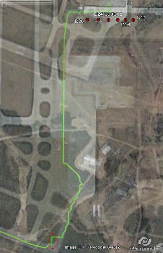
The first (biggest, single) 2-legged 90° angled position jump appears from above D20 downwards to just above the white D20 description.
That must be the first, 10 minutes costing Full Align. As I later assumed too, btw. The text in that picture can I not edit anymore, but there was 1 full, and 7 later, fast aligns.
Resulting in a nearly 30 meters sudden diagonal jump in that FDR's positional data for that full align.
Then I explain the next 7 times you find a 2 legged 90° angle showing 30 seconds taking, fast aligns.
If you subtract all 7 fast aligns and the 1 full align, their diagonal lengths, from that whole taxiing path, we end up in front of D26.
I showed 5 fast align points, but my encircled point 5 is in fact a combo of three 2 legged 90° fast aligns jumps.
And my encircled point 4 is in fact a combo of two 2 legged 90° fast aligns jumps.
Thus points 2 (1FA) + 3 (1FA) + 4 (2FA) + 5 (3FA) together make up 7 x 30 secs fast aligns.
Plus the Gate D26 departure 600 secs full align procedure makes up to 8 align procedures.
Costing minimum 600 + 210 = 810 secs, 17 minutes in total spend on all aligns.
WHY then those 7 additional fast aligns ?
When we know that the plane when its wheels off, will directly get its positional data updated in flight and thus corrected by the received new positional data from the radars.
So why that nervous fast align behavior?
Can you eventually explain these 7 fast aligns otherwise, and why did they occur then, when in your opinion it's not normal procedure, to perform that many fast aligns while taxiing (every time standing parked of course, in that taxi trajectory, otherwise fast and full aligns will not work).
new topics
-
I hate dreaming
Rant: 6 minutes ago -
Is the origin for the Eye of Horus the pineal gland?
General Conspiracies: 1 hours ago -
Man sets himself on fire outside Donald Trump trial
Mainstream News: 2 hours ago -
Biden says little kids flip him the bird all the time.
2024 Elections: 2 hours ago -
The Democrats Take Control the House - Look what happened while you were sleeping
US Political Madness: 2 hours ago -
Sheetz facing racial discrimination lawsuit for considering criminal history in hiring
Social Issues and Civil Unrest: 2 hours ago -
In an Historic First, In N Out Burger Permanently Closes a Location
Mainstream News: 4 hours ago -
MH370 Again....
Disaster Conspiracies: 5 hours ago -
Are you ready for the return of Jesus Christ? Have you been cleansed by His blood?
Religion, Faith, And Theology: 7 hours ago -
Chronological time line of open source information
History: 8 hours ago
top topics
-
In an Historic First, In N Out Burger Permanently Closes a Location
Mainstream News: 4 hours ago, 14 flags -
The Democrats Take Control the House - Look what happened while you were sleeping
US Political Madness: 2 hours ago, 9 flags -
Thousands Of Young Ukrainian Men Trying To Flee The Country To Avoid Conscription And The War
Other Current Events: 15 hours ago, 8 flags -
A man of the people
Medical Issues & Conspiracies: 10 hours ago, 8 flags -
Man sets himself on fire outside Donald Trump trial
Mainstream News: 2 hours ago, 6 flags -
Biden says little kids flip him the bird all the time.
2024 Elections: 2 hours ago, 6 flags -
4 plans of US elites to defeat Russia
New World Order: 11 hours ago, 4 flags -
Are you ready for the return of Jesus Christ? Have you been cleansed by His blood?
Religion, Faith, And Theology: 7 hours ago, 3 flags -
Is the origin for the Eye of Horus the pineal gland?
General Conspiracies: 1 hours ago, 3 flags -
Sheetz facing racial discrimination lawsuit for considering criminal history in hiring
Social Issues and Civil Unrest: 2 hours ago, 3 flags
active topics
-
Biden says little kids flip him the bird all the time.
2024 Elections • 9 • : FlyersFan -
12 jurors selected in Trump criminal trial
US Political Madness • 87 • : ImagoDei -
Fossils in Greece Suggest Human Ancestors Evolved in Europe, Not Africa
Origins and Creationism • 72 • : Xtrozero -
Is the origin for the Eye of Horus the pineal gland?
General Conspiracies • 3 • : purplemer -
I hate dreaming
Rant • 0 • : FlyersFan -
MH370 Again....
Disaster Conspiracies • 8 • : Lazy88 -
Do we live in a simulation similar to The Matrix 1999?
ATS Skunk Works • 27 • : purplemer -
Thousands Of Young Ukrainian Men Trying To Flee The Country To Avoid Conscription And The War
Other Current Events • 27 • : Xtrozero -
911 emergency lines are DOWN across multiple states
Breaking Alternative News • 8 • : nugget1 -
Marjorie Taylor Greene Files Motion to Vacate Speaker Mike Johnson
US Political Madness • 64 • : interupt42