It looks like you're using an Ad Blocker.
Please white-list or disable AboveTopSecret.com in your ad-blocking tool.
Thank you.
Some features of ATS will be disabled while you continue to use an ad-blocker.

Longtitude 112 degrees 35min 15.84sec.84W Latitude 32deg.43min.40.37sec.N
page: 5share:
Lots of goodies here in Nevada... triangles, circles, fake cities trains ans airplanes
Nellis AFB Bombing Range
Nevada
Area Layout
www.thelivingmoon.com...
Here is an old WWII photo of a similar SAM site

Nellis AFB Bombing Range
Nevada
Area Layout
www.thelivingmoon.com...
Here is an old WWII photo of a similar SAM site
Originally posted by Backslider
Here's a SS of this. It's interesting.
If you open in Google Earth you can see dirt roads leading to it, and leading south from this strange groups of roads to an airfield.
I didn't resize the image on purpose.
[atsimg]http://files.abovetopsecret.com/images/member/dd98cd5da238.png[/atsimg]
edit on 18-7-2011 by Backslider because: Is there some reason this isn't a scrollable image? I'm a nub.edit on 18-7-2011 by Backslider because: Fixin'
Someone on P.1 already said this but it seems like an AA emplacement indeed now i can actually loook at it.
Here is information on Naval Communication Station Harold E. Holt (North West Cape). Same Geometry and layout used in supposed bombing target.
www.nautilus.org...
As well as the two overlapping compasses. Drawing the coordinates on the tracing board would require an antenna if drawing them with frequency triangulation. .
All the similarities between War and Masonry are interesting. The great work requires building and tearing down and building it seems.
As well as the two overlapping compasses. Drawing the coordinates on the tracing board would require an antenna if drawing them with frequency triangulation. .
All the similarities between War and Masonry are interesting. The great work requires building and tearing down and building it seems.
edit on
19-7-2011 by HermitShip because: add
WOW that is one giant metal trap door , wonder what the hell they have in there !
it looks like something out of a bond movie !
it looks like something out of a bond movie !
reply to post by Arken
Not to detract from the “weirdness” of this. However it looks more like a concrete pad, not a metal door. But that just brings us to “why?” Metal door or concrete pad, either way it is odd. I can’t see any reason for a round pad like that, aside from a rocket launch pad or something similar. What is the location of this? Is there indeed some sort of rocketry facility nearby?
Not to detract from the “weirdness” of this. However it looks more like a concrete pad, not a metal door. But that just brings us to “why?” Metal door or concrete pad, either way it is odd. I can’t see any reason for a round pad like that, aside from a rocket launch pad or something similar. What is the location of this? Is there indeed some sort of rocketry facility nearby?
reply to post by Arken
Yeah we could fill a dozen threads easily with these things
I like this one

And look around the area of this one

Yeah we could fill a dozen threads easily with these things
I like this one
And look around the area of this one
Originally posted by HermitShip
Here is information on Naval Communication Station Harold E. Holt (North West Cape). Same Geometry and layout used in supposed bombing target.
Not quite Holt is laid out according to Sacred Geometry... to be precise a Metatron Cube
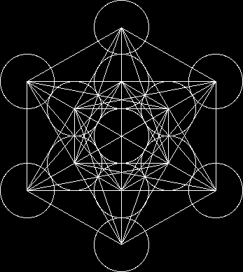

gives you an energy pattern like this

Originally posted by Skada
What about the larger picture. I tried highlighting some of the features.
[atsimg]http://files.abovetopsecret.com/images/member/68a4671d05a3.jpg[/atsimg]
What do you guys think? Any conspiracy here? In the middle of the compasses is a roman numeral 3 in a circle.
Link to pic.
files.abovetopsecret.com...edit on 7/18/2011 by Skada because: Added link to the pic to see the full image. Posting did not show the trangle on right.
Everyone knows who these compasses represents, the number 3 reffers to the 3rd degree in freemasonry, a mater mason level of great achievment and enlightnment.
A very obvious sign of how freemasons, military and government are all connected.
Here's another one, I havn't seen a pic of this one posted in the thread yet.
37°19'21.66"N 116°47'7.96"W
[atsimg]http://files.abovetopsecret.com/images/member/ff1b7d123d24.jpg[/atsimg]
37°19'21.66"N 116°47'7.96"W
[atsimg]http://files.abovetopsecret.com/images/member/ff1b7d123d24.jpg[/atsimg]
Originally posted by jude11
Didn't need to go to history. It is indeed a star.
edit on 18-7-2011 by jude11 because: (no reason given)
Even stranger...
edit on 18-7-2011 by jude11 because: (no reason given)
The second one seems to have 2 Freemason Compases in it.
Secondline.
edit on 19-7-2011 by Phenomium because: (no reason given)
reply to post by chardonnay
Certainly an odd coincidence (if it is coincidental that is). I cannot think of any particular advantage to shaping an installation and its dirt track roads in this manner. Of course, I have no idea what this installation actualy does, or what those service roads are designed to access. If there IS a logical reason for the placement, I would be very interested to know what that is.
Very mysterious. Good find OP!!
Originally posted by ChungTsuU
Originally posted by jude11
Didn't need to go to history. It is indeed a star.
edit on 18-7-2011 by jude11 because: (no reason given)
Even stranger...
edit on 18-7-2011 by jude11 because: (no reason given)
I was just going to put that up...There is a reverse of this same image across State Highway 85 at this location (the circle is on the left side):
32.665,-112.890
BTW this should be near the Goldwater Bombing Range if my memory is still working...
Regards and Nameste,
-Chung
How can there be a highway running theough a bombing range?? So close to all these targets?
I like the target theory, but can't make sence that thre is so much public access - the whole area has dozens of photographs on it....
Alright, its been said many times and many ways.... These are old bomb ranges that were predominantly used from WWII through the Vietnam era for
Practice. Most are no longer used. Basically, they are Geoglyphs much like the Nasca lines of Peru.
Here is a great site with plenty of pictures just from New Mexico. Nevada is also riddled with these targets like these. They also constructed fake runways/airstrips and even placed dead aircraft on the strips to be used as targets.
That's it. No Masonic cover up or agenda needed. I'm sorry to share this reality again.
home.comcast.net...
You really want to get funky look at the areas to the SE of Wendover airfield and the areas around Dugway in Utah. Plenty of targets to see.
edit on 19-7-2011 by jibeho because: (no reason given)
reply to post by Backslider
Those look like inciniary strifes, you know, kinda like Napalm, only a lot meaner...
Those look like inciniary strifes, you know, kinda like Napalm, only a lot meaner...
Originally posted by Arken
reply to post by zorgon
My personal contribution to this thread.
Tonopah, Area "S4"
A 250 meters in diameter of a metallic trap door....
I'd be more inclined to suggest that this looks like it's of a concrete composite surface as opposed to metallic one and there's nothing that would lead me to believe that it's a 'trap door' either. It appears a solid surface.
Concrete is laid in bays (rectangular, square etc) where the form work is set to accommodate longitudinal, expansion and contraction joints. The dimensions of the bays varies depending on the grade of concrete required for the sheduled loading. Where this image makes the surface look slightly pixelated with the rectangular/square shapes, seems to me, very likely to be concrete formed in bays (as it traditionally is).
What its exact purpose is, I have no idea, but I would hazard a guess at it being of military usage.
edit on 19-7-2011 by BAZ752 because: (no
reason given)
Ok so this begs the question:
Are these shapes and symbols actually superior defensive layouts?
Or are there better layouts that do not make fancy religious symbols but yet they are choosing inferior defensive shapes based on "how things look"?
Let me guess....
Are these shapes and symbols actually superior defensive layouts?
Or are there better layouts that do not make fancy religious symbols but yet they are choosing inferior defensive shapes based on "how things look"?
Let me guess....
Originally posted by muzzleflash
Ok so this begs the question:
Are these shapes and symbols actually superior defensive layouts?
Or are there better layouts that do not make fancy religious symbols but yet they are choosing inferior defensive shapes based on "how things look"?
Let me guess....
Yes! Thank you.
2nd this...
A U-2 flies over lets say, Hanoi, and takes lots of high res film pictures of the city and surrounding area. After the film is processed and examined,
a star shaped ground symbol is observed and upon closer examination it is determined to be a SAM site with radar.
An elite Air Force group called the Wild Weasels spring into action and set up similar sites on a bombing range and practice attacking it trying to determine the very best way.
Right before lets say, Operation Linebacker, the wild weasels fly in and take out the SAM sites, using the procedures and tactics learned from the pratice in the desert.
What you are seeing is military history.
new topics
-
George Knapp AMA on DI
Area 51 and other Facilities: 4 hours ago -
Not Aliens but a Nazi Occult Inspired and then Science Rendered Design.
Aliens and UFOs: 4 hours ago -
Louisiana Lawmakers Seek to Limit Public Access to Government Records
Political Issues: 6 hours ago -
The Tories may be wiped out after the Election - Serves them Right
Regional Politics: 7 hours ago -
So I saw about 30 UFOs in formation last night.
Aliens and UFOs: 9 hours ago -
Do we live in a simulation similar to The Matrix 1999?
ATS Skunk Works: 10 hours ago -
BREAKING: O’Keefe Media Uncovers who is really running the White House
US Political Madness: 11 hours ago
top topics
-
BREAKING: O’Keefe Media Uncovers who is really running the White House
US Political Madness: 11 hours ago, 23 flags -
George Knapp AMA on DI
Area 51 and other Facilities: 4 hours ago, 18 flags -
Biden--My Uncle Was Eaten By Cannibals
US Political Madness: 12 hours ago, 18 flags -
African "Newcomers" Tell NYC They Don't Like the Free Food or Shelter They've Been Given
Social Issues and Civil Unrest: 17 hours ago, 12 flags -
"We're All Hamas" Heard at Columbia University Protests
Social Issues and Civil Unrest: 12 hours ago, 7 flags -
Louisiana Lawmakers Seek to Limit Public Access to Government Records
Political Issues: 6 hours ago, 7 flags -
Russian intelligence officer: explosions at defense factories in the USA and Wales may be sabotage
Weaponry: 16 hours ago, 6 flags -
So I saw about 30 UFOs in formation last night.
Aliens and UFOs: 9 hours ago, 5 flags -
The Tories may be wiped out after the Election - Serves them Right
Regional Politics: 7 hours ago, 3 flags -
Not Aliens but a Nazi Occult Inspired and then Science Rendered Design.
Aliens and UFOs: 4 hours ago, 3 flags
active topics
-
Candidate TRUMP Now Has Crazy Judge JUAN MERCHAN After Him - The Stormy Daniels Hush-Money Case.
Political Conspiracies • 383 • : xuenchen -
OUT OF THE BLUE Chilling moment pulsating blue cigar-shaped UFO is filmed hovering over PHX AZ
Aliens and UFOs • 42 • : Ophiuchus1 -
George Knapp AMA on DI
Area 51 and other Facilities • 13 • : DumbNut -
Biden--My Uncle Was Eaten By Cannibals
US Political Madness • 43 • : DBCowboy -
-@TH3WH17ERABB17- -Q- ---TIME TO SHOW THE WORLD--- -Part- --44--
Dissecting Disinformation • 531 • : cherokeetroy -
So I saw about 30 UFOs in formation last night.
Aliens and UFOs • 20 • : Halfswede -
MULTIPLE SKYMASTER MESSAGES GOING OUT
World War Three • 33 • : Halfswede -
Not Aliens but a Nazi Occult Inspired and then Science Rendered Design.
Aliens and UFOs • 7 • : JonnyC555 -
Mood Music Part VI
Music • 3057 • : BatCaveJoe -
The Tories may be wiped out after the Election - Serves them Right
Regional Politics • 19 • : alwaysbeenhere2