It looks like you're using an Ad Blocker.
Please white-list or disable AboveTopSecret.com in your ad-blocking tool.
Thank you.
Some features of ATS will be disabled while you continue to use an ad-blocker.

Major event about to unfold before your eyes
page: 4share:
reply to post by Heartisblack
I think you will be OK. The Missouri River goes down from Montana to Nebraska. You have Iowa in between You and Nebraska, and the Mississippi river too. That flows into the Gulf, so as long as there is an outlet for the water downstream it will go that way. Being in northern Illinois, you might get localized flooding, but not this. At least that's my opinion. If you live in a low lying area or next to a river, I'd keep an eye on things. Also don't just go by the local weather predictions. Check Weather Channel. They are much more accurate about the coming weather than local lately. Hope that helps. Personally, I think no one really knows for sure all the stuff that's going to happen, because so many things are inter related. One thing affects another especially if something happens to those nuke plants in Nebraska. Try to stay safe, and not worry but prepare if you can for the worst, if that makes sense.
I think you will be OK. The Missouri River goes down from Montana to Nebraska. You have Iowa in between You and Nebraska, and the Mississippi river too. That flows into the Gulf, so as long as there is an outlet for the water downstream it will go that way. Being in northern Illinois, you might get localized flooding, but not this. At least that's my opinion. If you live in a low lying area or next to a river, I'd keep an eye on things. Also don't just go by the local weather predictions. Check Weather Channel. They are much more accurate about the coming weather than local lately. Hope that helps. Personally, I think no one really knows for sure all the stuff that's going to happen, because so many things are inter related. One thing affects another especially if something happens to those nuke plants in Nebraska. Try to stay safe, and not worry but prepare if you can for the worst, if that makes sense.
Originally posted by Heartisblack
Originally posted by works4dhs
Originally posted by TheBirdisDone
I feel like I am behind the iron curtain I swear. If not for this site and dedicated posters this would be unknown to me! I am now more then alarmed by what we are not hearing from the media. I never remember feeling quite this way in regard to what we are not being told. Why are we NOT being told what is going on. This is not China or the former USSR but you would certainly think so! Thanks for posting.edit on 22-6-2011 by TheBirdisDone because: (no reason given)
that's our media establishment for you. compare this to how much time/effort they put into Sarah Palin's emails, or this stupid Anthony trial (who CARES?!) floods and extreme weather barely get a nod. the Weather Channel often provides more useful info than the alphabets.
Amen but can somebody answer my question, I'm in North Illinois. Am I f -ed ?
Dude: grab a map; this is in Eastern Montanna. It would have to flood North or south dakota(flat but huge states); minnesota;cross the mississippi river floodplain; my state (wisconsin) before getting near northern Illinois.
edit on 22-6-2011 by 46ACE because: (no reason
given)
reply to post by Heartisblack
Did you even look at the link??
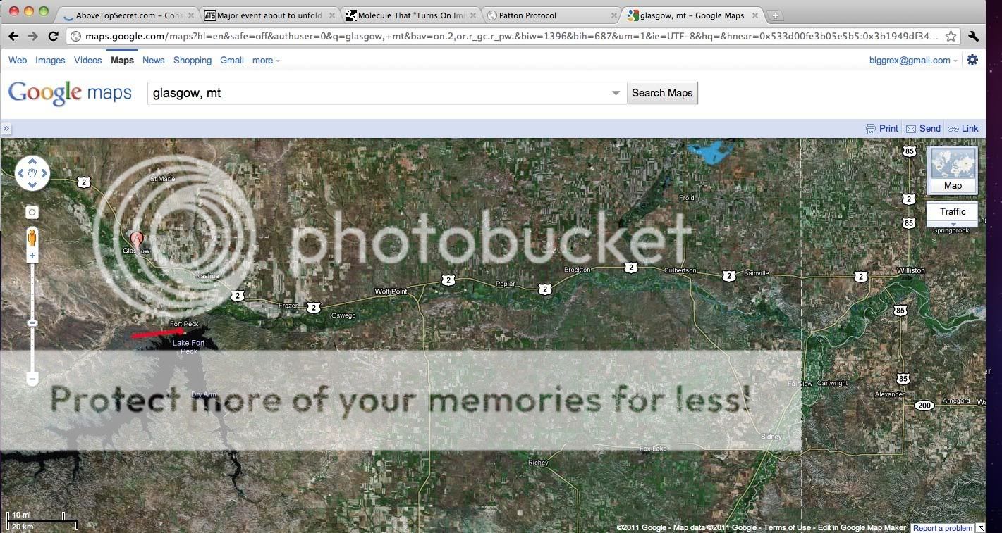
It is Glasgow, Montana, U.S. freakin A.
Not Ireland!!
Did you even look at the link??
It is Glasgow, Montana, U.S. freakin A.
Not Ireland!!
Speaking of flat land, the possibility of the dam breaking reminds me of an ice age dam that broke and dumped gallons of water over Eastern
Washington. It carved a gigantic roaring river channel and carried boulders and sediments. It made Eastern Washington look fascinating today.
(Missoula Floods) and PBS interactive of the
Missoula Floods
The land here was sediment and basalt. Anyone know of the land type in North or South Dakota? It's been so long since I lived in that area of the country.
The reason I ask is if it is weak land, (not made of granite or another hard rock) the rush of the water from such a large dam could carve a whole new river channel and possibly flood unsuspecting regions. Maybe the drier areas of the country may get their water.
Although when I lived near Omaha for three years I didn't like it or the rest of the midwest, now I'm just worried about the people who live in the area, it was once my home. Be careful and go with your instinct.
edit on 22-6-2011 by collietta because: (no reason given)
reply to post by 46ACE
Don't know if this was blacked out or not: Minot, Montana has been evacuated because of flooding from the Souris River. They were given 12 hours to get out, but the river began to cross over the dikes in the first hour. link
The ground is pretty watter-logged along the northern border.
Look everyone, I'm not in the US, but if I lived anywhere downstream from either of those overfilled dams I would leave and go to high ground ASAP. How much higher does the water have to get before TS really HTF?
Sending prayers and the best vibes I can muster to all concerned. This is really horrendous.
Originally posted by Heartisblack
Originally posted by funbox
well watch out for saturday and sunday , you got some bad storms on the way
glasgows weather
bar then its sunny and dry.so it is, och aye.
GlaswegianBox
Dude, we're in the USA. The Glasgow you're talking about is in Ireland. We're in the USA.....
The Fort Peck Dam is the highest of six major dams along the Missouri River, located in northeast Montana in the United States, near Glasgow, and adjacent to the community of Fort Peck. At 21,026 feet (6,409 m) in length and over 250 feet (76 m) in height, it is the largest hydraulically filled dam in the United States, and creates Fort Peck Lake, the fifth largest man-made lake in the U.S., more than 130 miles long, 200 feet deep, and it has a 1,520 mile shoreline which is longer than the state of California's coastline.[1] It lies within the Charles M. Russell National Wildlife Refuge. The dam and 134-mile (216 km) long lake exist for the purposes of hydroelectric power generation, flood control, and water quality management.[2]
USA
nice cath man. youd thik people in st louis would like to know about this.
I can't help but think just how easy it would be for them to make this look like it's a perfectly natural disaster - Yip - I'd be getting out of
there pretty sharpe.
If you can't afford to sell up or what ever your reason for hanging on - at least move out to family or friends or live in a bloody trailer if you have to - at least you'll be alive. Give it 6 months and then take another look.
If you can't afford to sell up or what ever your reason for hanging on - at least move out to family or friends or live in a bloody trailer if you have to - at least you'll be alive. Give it 6 months and then take another look.
Hopefully they at least gave people around there, at least a word of what might possibly be happening, even if nothing happens at all. It still
would be better then saying nothing, so whats with the black out on this. It makes absolutely no sense. I think people would rather be a
little prepared, then sorry.
Dam gubment I swear sometimes its like we would be better of if we had chimps running the place. I mean we send them in space and they seem to do alright so might as well see how they do at running basic procedures and calls.
Anyways this is news to me.
Dam gubment I swear sometimes its like we would be better of if we had chimps running the place. I mean we send them in space and they seem to do alright so might as well see how they do at running basic procedures and calls.
Anyways this is news to me.
Originally posted by SatoriTheory
Originally posted by Anonymous Avatar
Keep your pants on people.
What? Even when they are full of the brown stuff?
st.
If HAARP is set to maximum level 5 and has a red light flashing in the basement, you won't care about the brown stuff.
I mean it has a red light!
Originally posted by Heartisblack
Originally posted by maya27
reply to post by Heartisblack
Glasgow is in Scotland, in the UK.
The map he linked was for the UK & Ireland.
I know this, that's why I told him.
Actually you told him Glasgow is in Ireland.
But what I don't get is the Glasgow in the link he provided is for Glasgow, Montana, United States...
Is that a real place? google says it is.
I'm confused...
There's a mighty big storm crossing the Idaho Panhandle near Grangeville with torrential rains. Townsend, Mt. is just over the Bitteroot Divide, and
if this storm hits the headwaters of the Big Muddy there, it ain't go'in to help, per this thread. The operators at Grand Coulee Dam were sued by a
downstream fish farm for nitrogen saturation last week, and the Bureau of Reclamation got around it be calling this high water year, an "Act of
God". So why was that Dam built in the first place? 11 PM here on Mountain Time, June 22. 2011. If Fort Peck is really at risk, the Gov't should
be dumping water like crazy from every downstream dam on the Missouri River. Here, Dworshak Dam on the North Fork of the Clearwater River has been
almost drawn down all Spring.
Well I guess we know what they have planned now. One quake and everything along the Mississippi will be wiped out. This really sucks. I really wish
these evil scum did not run this country.
reply to post by collietta
The scab lands, in eastern Washington were created because of that flood. And I have been there a couple of times in the summer months. Usually camping with friends and swimming in the lakes/man made lakes in the area. It's really a pretty amazing place there, kind of like a mix between a desert and plain lands, with lakes and little rivers connecting them here and there all throughout the area.
Heres some random pics of the place of the net.

It's a pretty cool place to camp, only you just got to watch out were your at, since its really in the middle of nowhere most times "or at least the places we went at was off the beaten path, and off-course the rattlesnakes. Got to be careful of them rattlesnakes! Especially if you have to use the bathroom in the middle of the night were you can't see #, and doing it nature style, "by a bunch of bushes"
Ah fun times, fun times. There's nothing like taking a squat and wondering what that noise that you hear near by could be, in the middle of the night, in the middle of nowhere.
Anyways back to topic.
The scab lands, in eastern Washington were created because of that flood. And I have been there a couple of times in the summer months. Usually camping with friends and swimming in the lakes/man made lakes in the area. It's really a pretty amazing place there, kind of like a mix between a desert and plain lands, with lakes and little rivers connecting them here and there all throughout the area.
Heres some random pics of the place of the net.
It's a pretty cool place to camp, only you just got to watch out were your at, since its really in the middle of nowhere most times "or at least the places we went at was off the beaten path, and off-course the rattlesnakes. Got to be careful of them rattlesnakes! Especially if you have to use the bathroom in the middle of the night were you can't see #, and doing it nature style, "by a bunch of bushes"
Ah fun times, fun times. There's nothing like taking a squat and wondering what that noise that you hear near by could be, in the middle of the night, in the middle of nowhere.
Anyways back to topic.
edit on 23-6-2011 by galadofwarthethird because: (no reason given)
reply to post by carpooler
Every dam on the Missouri is dumping water as fast as they can already. If I heard the Weather Channel correctly, they are all dumping water at record or near record rates, and it just isn't fast enough.
The last I checked a few days ago, the water equivalent in the snowpack was around 9', and that snowpack is starting to melt fast. None of the dams has more than a foot or so of space left, so you do the math.
If that first one overtops, it will dissolve, and a 200' wall of water with over a hundred miles of pressure behind it will shortly go crashing down the river. I doubt most seriously if any of the lower dams could withstand, and as the dam failures cascade, each will add it depth and pressure to the flow.
It won't be pretty.
Unfortunately, it seems inevitable, merely a question of when.
edit on 23-6-2011 by apacheman because: (no reason given)
Originally posted by galadofwarthethird
reply to post by collietta
The scab lands, in eastern Washington were created because of that flood. And I have been there a couple of times in the summer months. Usually camping with friends and swimming in the lakes/man made lakes in the area. It's really a pretty amazing place there, kind of like a mix between a desert and plain lands, with lakes and little rivers connecting them here and there all throughout the area.
Anyways back to topic.edit on 23-6-2011 by galadofwarthethird because: (no reason given)
That's what I was getting at. The dam in Montana reminded me of the Missoula floods. If the dam bursts it may carve a whole new river channel or create a new area that looks like eastern Washington. Depending on where the low areas are, people who aren't near the Missouri river flood path, may find themselves unexpectedly in the path of this dam water.
Who are the idiots that planned where to built these nucelar plants? Japan has one right on a fault line next to the ocean, and America has one right
next to the Missouri River?
edit on 23-6-2011 by TupacShakur because: To edit my post
reply to post by kdial1
What a mess, I hope your calculations are wrong. Or at least inaccurate.
When swamping occurs, move to higher ground.
Ride the Bluesman train to Chicago.
Make sure to add a Harmonica to you BackPack. Toss your Cell Phone in the river.
Make us proud.
What a mess, I hope your calculations are wrong. Or at least inaccurate.
When swamping occurs, move to higher ground.
Ride the Bluesman train to Chicago.
Make sure to add a Harmonica to you BackPack. Toss your Cell Phone in the river.
Make us proud.
I am an occasional visitor of this site when i catch something interesting posted to facebook from ATS, and this topic caught my eye. I read the
original post and the comments, which lead me to look into it a little for myself, and i found this interesting link(some of you may have already seen
it, i don't know), which prompted me to register on ATS.
This scenario, 'The Fort Peck Incident', was written in 2008, a little different scenario than the reality occuring however. There is one comment from '09, then suddenly one on May 20th and then 6 since June 10th. I've yet to turn on the tv to see what, if anything is being reported, but will soon. I will be keeping my eyes and ears on this one.
Glad to finally join the conversation
www.futuristspeaker.com...
new topics
-
Supreme Court Oral Arguments 4.25.2024 - Are PRESIDENTS IMMUNE From Later Being Prosecuted.
Above Politics: 41 minutes ago -
Krystalnacht on today's most elite Universities?
Social Issues and Civil Unrest: 50 minutes ago -
Chris Christie Wishes Death Upon Trump and Ramaswamy
Politicians & People: 1 hours ago -
University of Texas Instantly Shuts Down Anti Israel Protests
Education and Media: 3 hours ago -
Any one suspicious of fever promotions events, major investor Goldman Sachs card only.
The Gray Area: 5 hours ago -
God's Righteousness is Greater than Our Wrath
Religion, Faith, And Theology: 10 hours ago
top topics
-
VP's Secret Service agent brawls with other agents at Andrews
Mainstream News: 14 hours ago, 11 flags -
Nearly 70% Of Americans Want Talks To End War In Ukraine
Political Issues: 15 hours ago, 5 flags -
Sunak spinning the sickness figures
Other Current Events: 15 hours ago, 5 flags -
Electrical tricks for saving money
Education and Media: 13 hours ago, 4 flags -
Late Night with the Devil - a really good unusual modern horror film.
Movies: 17 hours ago, 3 flags -
Krystalnacht on today's most elite Universities?
Social Issues and Civil Unrest: 50 minutes ago, 3 flags -
Supreme Court Oral Arguments 4.25.2024 - Are PRESIDENTS IMMUNE From Later Being Prosecuted.
Above Politics: 41 minutes ago, 3 flags -
Any one suspicious of fever promotions events, major investor Goldman Sachs card only.
The Gray Area: 5 hours ago, 2 flags -
University of Texas Instantly Shuts Down Anti Israel Protests
Education and Media: 3 hours ago, 2 flags -
Chris Christie Wishes Death Upon Trump and Ramaswamy
Politicians & People: 1 hours ago, 1 flags
active topics
-
British TV Presenter Refuses To Use Guest's Preferred Pronouns
Education and Media • 149 • : Annee -
Hate makes for strange bedfellows
US Political Madness • 46 • : network dude -
University of Texas Instantly Shuts Down Anti Israel Protests
Education and Media • 65 • : FlyersFan -
The Reality of the Laser
Military Projects • 48 • : 5thHead -
Nearly 70% Of Americans Want Talks To End War In Ukraine
Political Issues • 69 • : SchrodingersRat -
Supreme Court Oral Arguments 4.25.2024 - Are PRESIDENTS IMMUNE From Later Being Prosecuted.
Above Politics • 1 • : network dude -
Candidate TRUMP Now Has Crazy Judge JUAN MERCHAN After Him - The Stormy Daniels Hush-Money Case.
Political Conspiracies • 744 • : Threadbarer -
Truth Social goes public, be careful not to lose your money
Mainstream News • 129 • : matafuchs -
Krystalnacht on today's most elite Universities?
Social Issues and Civil Unrest • 2 • : marg6043 -
Remember These Attacks When President Trump 2.0 Retribution-Justice Commences.
2024 Elections • 56 • : WeMustCare