It looks like you're using an Ad Blocker.
Please white-list or disable AboveTopSecret.com in your ad-blocking tool.
Thank you.
Some features of ATS will be disabled while you continue to use an ad-blocker.

Army Corps detonates explosives on flood levee
page: 2share:
reply to post by zorgon
I am not a HAARPIE, you say on HAARP threads that they can cause earthquakes and go on and on about it. I have never even posted on a HAARP
thread. I have known about Scalar Weapons in the 1990s, but this is only the second time I have ever mentioned HAARP on ATS. You even stated on a
HAARP thread that they do cause earthquake, and are a military weapon.
I know you are worshipped like a god on here, so you should be a positive example and be nice to little old ladies. I have never personally said anything against you.
I know you are worshipped like a god on here, so you should be a positive example and be nice to little old ladies. I have never personally said anything against you.
Originally posted by coolottie
so you should be a positive example and be nice to little old ladies.
Well the 'Haarpie" comment was directed in general not at you personally. It's just that every EQ or other disaster thread theses days it doesn't take long for HAARP to be dragged into it as the cause, yet no one does more than make the statement with no data to back it up. So you said there was a spike close to the time that the dam blew... I asked how do you think that is related?
reply to post by zorgon
I did not say HAARP was responsible for flood. You through up a map of Artic Melting, but that didn't cause the flood either. You are out there in Vagus, but I am here and can lose everything I own, so I am going to look at all possiblities. Right now I am mad as hell, they go flood thousands of the best farm land in the country, just to get the river down 1 ft. 6 in. . That much would be down in a few days anyway. Plus then blow up 2 more places so the water can go back into the River. And the other thread you went on just minutes after relpying to my post on here, belittling the Map I posted. The map the day before that just showed red, the dates were for
May 2-3. Now the Map showing my state completely covered in water except for 3-4 counties, is dated
May 2-7, projecting 4 days in advance. They are going to blow up levees all the way down, instead of opening the floodgate areas that are for River run off. I don't just look at a subject from one angle, I consider them all, especially when I can loose everything, and they destroy 60 homes and lives just to get the River down a foot.
reply to post by zorgon
Here is all the info on all of the CoE and the floodgates just finished, that I guess we don't need anymore since they are blowing up all the levees.
www.mvn.usace.army.mil...
Here is all the info on all of the CoE and the floodgates just finished, that I guess we don't need anymore since they are blowing up all the levees.
www.mvn.usace.army.mil...
just a right field thought here, but has anyone considered the isle of HAITI quake as a warning for HAYTI, MO as a possible target for the new madrid
quake? TPTB work mysteriously, but ALWAYS hidden in plain sight.
i am looking into it right now and not finding out much. anyone care to join me?
i am looking into it right now and not finding out much. anyone care to join me?
Originally posted by coolottie
Here is all the info on all of the CoE and the floodgates just finished, that I guess we don't need anymore since they are blowing up all the levees.
I like this comment from that link...
The project is designed to reduce the risk of flooding caused by a storm surge that has a 1% chance of occurring each year.
1% Who does their math?
I still think the concern was the weight of water considering the recent quakes caused by that fracking. I am willing to bet someone in that ivory tower was concerned it may trigger a big one so took the gamble
But one question on the farmland. Isn't the annual flooding what makes the area so fertile? It is on the Nile...
As to Vagus... well we have been seeing really odd series of quakes at the edge of Long Valley near Hawthorn. I moved here to escape, floods, quakes, foul weather, tornadoes, hurricanes etc... only to find that both Long Valley and Yellowstone Calderas are really stirring up...
I guess there is no safe place on this planet... but my beef is with people who blame HAARP and the PTB for everything without looking at the big picture as you say you have done... Mother Earth is going through changes, so is the solar system. We are in for a rough ride because the scientists that work for the PTB are STUMPED... they have no clue as to why all this is happening.
And people need to remember that the PTB and the rich families also live in the effected areas around the world?. Why would they destroy their own homes and those of their families?
Using HAARP scalar waves to rumble the earth was proven a bad idea by Russia years ago, because while you can start it... you cannot stop it. It scared the pants off the Russian rulers, to the point they even called the Whitehouse.
As to your situation... All best hopes that you will get through this safely
Edit to Add... this was just posted by Susan Frey in the Arkansas EQ thread... a video stating that the NWO is planning to trigger the fault and these bombs were the first step.
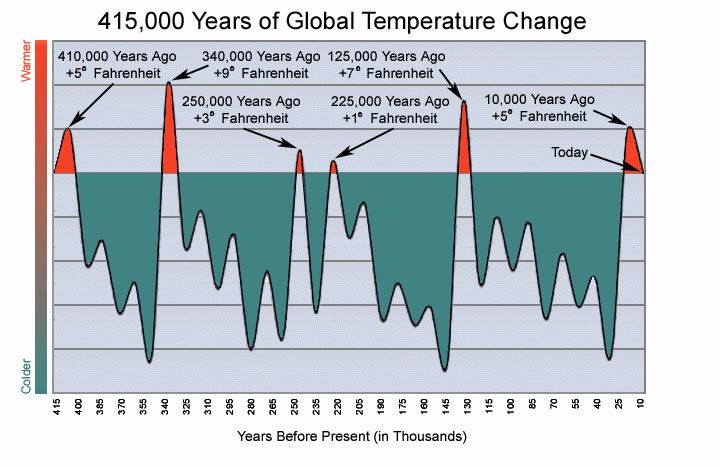
Aww well won't matter soon anyway... ice age is on the way... and that data comes from Ice Core samples in Antarctica recorded over 415,000 years. Maybe all the earth changes are leading up to that, since no one was around the last cooling spell to record events prior to that.
The magnetic poles are moving 4 times faster, the last few big eq's have actually effected earth's orbit shifting and speeding up the planet...
I think I will go out and cut some more firewood. April in Vegas has been the coldest wettest and windiest on record.
edit on 4-5-2011 by
zorgon because: (no reason given)
reply to post by zorgon
I watched a documentary on ufotv on youtube about an arrowhead and a few other artifacts found in Virgina that dated back to 17,000 years ago, the last Ice Age. They traveled all the way across the Atlantic Ocean during this Ice Age. Also proof that they survived in America. Mankinds will to survive is so much stronger than we realize and we are a lot strong than we give ourselves credit for.
It is my theory which I used in the start of my book, that the earth goes through this cycle, where there is an ice crystal bubble around the earth and like they first called it "Green House Effect", This has happened many times where archaelogist could not find that anything thing on the planet died for 100,000 years. This crystal bubble is formed when the Sun draws water up to the upper atomosphere and it forms a protective bubble that, people and plants and all life forms live for thousands of years. The chemtrails and all this messing with the weather is preventing this, so the water goes up and then comes right back down. Plus this pull is causing earthquakes, active volcanos etc. If they would just leave everything alone the earth will return to the Paradise it has been in the past. So there is a very positive outcome without mans interferrence.
Zorgon, you freeze to death in Vagus and I will know we are in trouble, stay warm.
reply to post by zorgon
See, they knew they were going to bomb the levee in Aug. 2010. Did they tell the farmers, hell no!
Link: www.mvm.usace.army.mil...
See, they knew they were going to bomb the levee in Aug. 2010. Did they tell the farmers, hell no!
The existing Plan of Operation for the Floodway was reviewed by Missouri state officials in November 1985 and approved by the President, MRC, in January 1986. The plan required modification to the frontline levee which includes raising 12,500 feet of the upper fuseplug and 7,500 feet of the lower fuseplug and installing horizontal polyethylene pipe in three crevasse locations. These crevasse locations are designated as Inflow, Inflow/Outflow No. 1 and Inflow/Outflow No. 2. In addition to the modifications to the frontline levee, all materials, including the blasting agent which will be pumped into the pipes in the levee, and equipment necessary to place the floodway into operation have been acquired by the Memphis District.
Link: www.mvm.usace.army.mil...
3.1 SE Missouri Levee Blast36.95°N -89.14°W 0Km Deep 2011-05-03 03:02:50 UTC1970-01-01 00:00:00 US2011KLAI
So the levee blastings are registering (or creating earthquakes all together) on the USGS.....
and they are doing so along the Mississippi on the New Madrid fault.
So the levee blastings are registering (or creating earthquakes all together) on the USGS.....
and they are doing so along the Mississippi on the New Madrid fault.
new topics
-
Israeli Missile Strikes in Iran, Explosions in Syria + Iraq
World War Three: 10 seconds ago -
George Knapp AMA on DI
Area 51 and other Facilities: 5 hours ago -
Not Aliens but a Nazi Occult Inspired and then Science Rendered Design.
Aliens and UFOs: 5 hours ago -
Louisiana Lawmakers Seek to Limit Public Access to Government Records
Political Issues: 8 hours ago -
The Tories may be wiped out after the Election - Serves them Right
Regional Politics: 9 hours ago -
So I saw about 30 UFOs in formation last night.
Aliens and UFOs: 11 hours ago
top topics
-
BREAKING: O’Keefe Media Uncovers who is really running the White House
US Political Madness: 12 hours ago, 25 flags -
George Knapp AMA on DI
Area 51 and other Facilities: 5 hours ago, 19 flags -
Biden--My Uncle Was Eaten By Cannibals
US Political Madness: 13 hours ago, 18 flags -
"We're All Hamas" Heard at Columbia University Protests
Social Issues and Civil Unrest: 13 hours ago, 7 flags -
Louisiana Lawmakers Seek to Limit Public Access to Government Records
Political Issues: 8 hours ago, 7 flags -
Russian intelligence officer: explosions at defense factories in the USA and Wales may be sabotage
Weaponry: 17 hours ago, 6 flags -
So I saw about 30 UFOs in formation last night.
Aliens and UFOs: 11 hours ago, 5 flags -
The Tories may be wiped out after the Election - Serves them Right
Regional Politics: 9 hours ago, 3 flags -
Do we live in a simulation similar to The Matrix 1999?
ATS Skunk Works: 12 hours ago, 3 flags -
Not Aliens but a Nazi Occult Inspired and then Science Rendered Design.
Aliens and UFOs: 5 hours ago, 3 flags
active topics
-
Israeli Missile Strikes in Iran, Explosions in Syria + Iraq
World War Three • 0 • : FamCore -
Candidate TRUMP Now Has Crazy Judge JUAN MERCHAN After Him - The Stormy Daniels Hush-Money Case.
Political Conspiracies • 386 • : WeMustCare -
British TV Presenter Refuses To Use Guest's Preferred Pronouns
Education and Media • 61 • : nugget1 -
-@TH3WH17ERABB17- -Q- ---TIME TO SHOW THE WORLD--- -Part- --44--
Dissecting Disinformation • 535 • : cherokeetroy -
African "Newcomers" Tell NYC They Don't Like the Free Food or Shelter They've Been Given
Social Issues and Civil Unrest • 15 • : marg6043 -
Alabama Man Detonated Explosive Device Outside of the State Attorney General’s Office
Social Issues and Civil Unrest • 58 • : Unknownparadox -
BREAKING: O’Keefe Media Uncovers who is really running the White House
US Political Madness • 13 • : WeMustCare -
"We're All Hamas" Heard at Columbia University Protests
Social Issues and Civil Unrest • 127 • : marg6043 -
Two Serious Crimes Committed by President JOE BIDEN that are Easy to Impeach Him For.
US Political Madness • 16 • : WeMustCare -
911 emergency lines are DOWN across multiple states
Breaking Alternative News • 6 • : nugget1