It looks like you're using an Ad Blocker.
Please white-list or disable AboveTopSecret.com in your ad-blocking tool.
Thank you.
Some features of ATS will be disabled while you continue to use an ad-blocker.

New imagery at the Lockheed Martin Yucca Lake facility
page: 1share:
36°55'35.80"N 116° 0'25.74"W
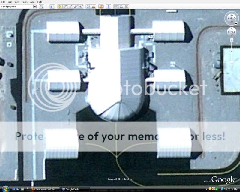
The is one cool "barn door". I can't say I ever saw that kind of hangar design.
The is one cool "barn door". I can't say I ever saw that kind of hangar design.
Not to mention this is only a few kilometres from Area 51 . Maybe this is where the keep the flying Saucer
That sure is an interesting shape for a hangar though; especially the opening...
That sure is an interesting shape for a hangar though; especially the opening...
reply to post by Sly1one
Did the same thing i guess i'll post it from a different angle
[atsimg]http://files.abovetopsecret.com/images/member/b920fde11de4.jpg[/atsimg]
Did the same thing i guess i'll post it from a different angle
[atsimg]http://files.abovetopsecret.com/images/member/b920fde11de4.jpg[/atsimg]
For those who haven't tracked this facility or don't recall my old posts, use the time slider to get back to 3/21/2007 That is the imagery with a
PC-12 and C-12 on the ground. Presumably one of the Lockheed Martin PC-12 shuttles that leave KVGT or KBLD, and of course the Beechcraft Janet
C-12.
This facility was built with dubious public input. There is a post on ATS where I posted a study from the NTS approving the construction of this facility. But it was never revealed to the public prior to construction, but rather just the Desert Research Institute IIRC. When the new runway appeared on Google Earth, I phoned the NTS reading room and got the run around. Checking with Nevada environmental got me no where either. So they did the environmental study in a very backdoor under the table manner. Then a few years after it was done they just dumped the environmental study on the net with no real announcement.
Note that there is new 2009 imagery around Site-4 (not S-4) near Tonopah, and some nearby areas. They didn't put new imagery up for the TTR or the Keno airstrip, but it wouldn't surprise me if it showed up soon.
Back to this new Lockheed facility, I'm stumped as to the design. So we have small hangars that lead to a large hangar with a curved door. What does a curved door buy you? Why are the buildings interconnected?
It is believed Polecat flew from this facility. This canyon is very hard to snoop on. A bit of the new facility can be seen from Bonanza Peak and perhaps Mount Stirling.
Originally posted by gariac
Back to this new Lockheed facility, I'm stumped as to the design. So we have small hangars that lead to a large hangar with a curved door. What does a curved door buy you? Why are the buildings interconnected?
Thanks for your interesting pieces of information everytime gariac, I enjoy'em very much!
As for the quoted text did you ask rhetorical questions or do you really don't know? (Because I'm interested in what you have to say about your own questions )
reply to post by Dalbeck
Nope, the interconnection seems goofy to me. At the very least, should something bad happen regarding noxious fumes, you might want the barns isolated. Some of these UAVs run on hydrazine.
If the large barn was squared off, the building might be in the way of the wing of a plane using one of the other barns. Note the tightness of the taxiways. Of course with no limit on desert dirt, they could just space out the buildings further and get around that problem. But if you needed to curve the front of a barn, this carousel scheme they used for the door would be the only solution. However, it wouldn't also have to expose the top area near the door.
This might just be a way to set up a work facility where the butt end of the plane and exhaust goes to this rounded portion of the hangar. Often in the desert they use a roof on poles, i.e. open air on all surfaces but the top, for maintenance structures. This way workers can stay out of the sun. But if you had a secret UAV, you might want more privacy.
These are all just rambling guesses.....
I wonder what UAV it is they are testing there. Looks like the two barns have about a 57 ft. width, the curved door on the main hangar about 71 ft.
This, maybe?
www.lockheedmartin.com...
This, maybe?
www.lockheedmartin.com...
reply to post by gariac
Hey, don't know if you ran across this, NVH1 was mentioned in this Honeywell doc. www51.honeywell.com...
Hey, don't know if you ran across this, NVH1 was mentioned in this Honeywell doc. www51.honeywell.com...
Originally posted by FosterVS
I wonder what UAV it is they are testing there. Looks like the two barns have about a 57 ft. width, the curved door on the main hangar about 71 ft.
This, maybe?
www.lockheedmartin.com...
In one of the pdf docs gariac posted listed one of the hangar's name as "Falcon Hangar". Maybe Lockheed's Falcon? Just a fun thought.
edit on
3/25/2012 by DesertWatchdog because: spelling
reply to post by DesertWatchdog
I have a few threads on this facility. I don't believe I mentioned that document, but that is my source. You can use the search function on NVH1 and/or Yucca. This is the one I like because I suspect a county supervisor got the facility named after her.
www.abovetopsecret.com...
This facility just popped up on Google Earth. No environmental reports until way after it was built. Clearly a few civilians knew it was being built. Except for Groom Lake, all construction needs some environmental review.
This airport is mighty tough to observe from the "free world." It shows you how a real spook planner can site a project versus some clown like Lazar. However, it might also be that the other side of Yucca dry lake is used for the chemical spill facility, and perhaps they wanted some distance from it.
When you tour the NTS, you cannot bring binocs. This facility can be seen, but just barely. You can't bring a camera either, though some moron took a shot of Gate 700, probably from a cell phone camera. Crap like that can cause the tours to be eliminated.
Originally posted by gariac
reply to post by DesertWatchdog
I have a few threads on this facility. I don't believe I mentioned that document, but that is my source. You can use the search function on NVH1 and/or Yucca. This is the one I like because I suspect a county supervisor got the facility named after her.
www.abovetopsecret.com...
This facility just popped up on Google Earth. No environmental reports until way after it was built. Clearly a few civilians knew it was being built. Except for Groom Lake, all construction needs some environmental review.
This airport is mighty tough to observe from the "free world." It shows you how a real spook planner can site a project versus some clown like Lazar. However, it might also be that the other side of Yucca dry lake is used for the chemical spill facility, and perhaps they wanted some distance from it.
When you tour the NTS, you cannot bring binocs. This facility can be seen, but just barely. You can't bring a camera either, though some moron took a shot of Gate 700, probably from a cell phone camera. Crap like that can cause the tours to be eliminated.
Agreed, saw the same photo you're talking about. the "Falcon hangar" came from the environmental report you posted. Like I said, just a fun thought. I'm guessing the diagrams they showed can't be requested? Since I'm a flight sim developer, that caught my attention right away.
reply to post by DesertWatchdog
Those documents have left the DOE website. I thought I archived the AOF documents, but mine shows 0 bytes. Maybe someone else saved them.
Under normal circumstances, you could get the prints for the structure. I pull such stuff off the fbo,gov website all the time. That is, the construction goes out to bid, and you can't bid without plans. In the case of the AOF, the government didn't build the facility, so getting the documents isn't quite as easy. [That is, Lockheed did the bid requests.]
In theory, there are plans on file with the county. However, given the shady nature of how this facility was built, I wouldn't bet on getting them without doing some arm twisting. If this were in Lincoln county, I wouldn't even bother trying to get the plans. Nye county is far less corrupt than Lincoln. They probably exist in electronic form. You would have to do a public records request.
www.nyecounty.net...
Originally posted by gariac
reply to post by DesertWatchdog
Those documents have left the DOE website. I thought I archived the AOF documents, but mine shows 0 bytes. Maybe someone else saved them.
Under normal circumstances, you could get the prints for the structure. I pull such stuff off the fbo,gov website all the time. That is, the construction goes out to bid, and you can't bid without plans. In the case of the AOF, the government didn't build the facility, so getting the documents isn't quite as easy. [That is, Lockheed did the bid requests.]
In theory, there are plans on file with the county. However, given the shady nature of how this facility was built, I wouldn't bet on getting them without doing some arm twisting. If this were in Lincoln county, I wouldn't even bother trying to get the plans. Nye county is far less corrupt than Lincoln. They probably exist in electronic form. You would have to do a public records request.
www.nyecounty.net...
I did save them. I'll haffta dig them up.
reply to post by DesertWatchdog
www.lazygranch.com...
I found one document. But I think there was one more specific to the hangars. Have you looked for your files?
www.lazygranch.com...
I found one document. But I think there was one more specific to the hangars. Have you looked for your files?
Originally posted by gariac
reply to post by DesertWatchdog
www.lazygranch.com...
I found one document. But I think there was one more specific to the hangars. Have you looked for your files?
All I have. thebox.mongoworks.com...
Hey gariac,
I was kind of curious about this report and its mention of the "Lost Link Aerial Operations Facility" from 2001.
thebox.mongoworks.com...
Page 19
"Table 2. Summary of biological surveys conducted on the NTS during FY2001"
"01-11 Construction of runway and pad for Lost Link Aerial Operations Facility"
Could this be an early name of the Yucca AOF? I tried to find more on this Lost Link AOF and came up with nothing. Figured maybe you could or already have.
edit on 4/24/2012 by DesertWatchdog because: (no reason given)
reply to post by DesertWatchdog
I'm not sure either way. "Lost Link" probably refers to the problem of what to do with a UAV when you lose communications. [Buzz phrase is lost link mission planning.] There is a hand off between ground control and satellite control. Ground control is line of sight. Satellite is everywhere, but lock is an issue. I suppose they could set up a runway in some spot where if the hand-off didn't work, they could recover the UAV with another ground station down stream. But that Lost Link site wouldn't necessarily have to be at Yucca Dry Lake.
From a current FBO request:
www.fbo.gov...
There is a Predator crash near Creech where control was lost so the UAV went into orbit mode. It orbited into a mountain. ;-) I have the FOIA someplace. The press report was written so poorly that it sounded like the UAV crashed in free territory, but when I got the crash report, it was clear that it crashed on the range.
I've never seen this first hand, but they fly Predators from Creech to Ft. Irwin. It must be tough on air traffic control since radar coverage is not so great over route 95. But it wouldn't surprise me if there are way to recover the UAVs en route.
I'm not sure either way. "Lost Link" probably refers to the problem of what to do with a UAV when you lose communications. [Buzz phrase is lost link mission planning.] There is a hand off between ground control and satellite control. Ground control is line of sight. Satellite is everywhere, but lock is an issue. I suppose they could set up a runway in some spot where if the hand-off didn't work, they could recover the UAV with another ground station down stream. But that Lost Link site wouldn't necessarily have to be at Yucca Dry Lake.
From a current FBO request:
www.fbo.gov...
3. Lost Link Performance - In the event of loss of data link, the aircraft must execute a preplanned, user-programmable mission profile to facilitate restoration of the data link and minimize collateral damage if the link cannot be reestablished. Describe the lost link profile capability of the VTOL UA for (1.) automatic landing, (2.) zeroization of cryptographic variables, (3.) cooperative traffic avoidance, (4.) uncooperative traffic avoidance, (5.) obstacle avoidance, (6.) reporting on traffic and obstacles if link is reestablished
There is a Predator crash near Creech where control was lost so the UAV went into orbit mode. It orbited into a mountain. ;-) I have the FOIA someplace. The press report was written so poorly that it sounded like the UAV crashed in free territory, but when I got the crash report, it was clear that it crashed on the range.
I've never seen this first hand, but they fly Predators from Creech to Ft. Irwin. It must be tough on air traffic control since radar coverage is not so great over route 95. But it wouldn't surprise me if there are way to recover the UAVs en route.
Originally posted by gariac
reply to post by DesertWatchdog
I'm not sure either way. "Lost Link" probably refers to the problem of what to do with a UAV when you lose communications. [Buzz phrase is lost link mission planning.] There is a hand off between ground control and satellite control. Ground control is line of sight. Satellite is everywhere, but lock is an issue. I suppose they could set up a runway in some spot where if the hand-off didn't work, they could recover the UAV with another ground station down stream. But that Lost Link site wouldn't necessarily have to be at Yucca Dry Lake.
From a current FBO request:
www.fbo.gov...
3. Lost Link Performance - In the event of loss of data link, the aircraft must execute a preplanned, user-programmable mission profile to facilitate restoration of the data link and minimize collateral damage if the link cannot be reestablished. Describe the lost link profile capability of the VTOL UA for (1.) automatic landing, (2.) zeroization of cryptographic variables, (3.) cooperative traffic avoidance, (4.) uncooperative traffic avoidance, (5.) obstacle avoidance, (6.) reporting on traffic and obstacles if link is reestablished
There is a Predator crash near Creech where control was lost so the UAV went into orbit mode. It orbited into a mountain. ;-) I have the FOIA someplace. The press report was written so poorly that it sounded like the UAV crashed in free territory, but when I got the crash report, it was clear that it crashed on the range.
I've never seen this first hand, but they fly Predators from Creech to Ft. Irwin. It must be tough on air traffic control since radar coverage is not so great over route 95. But it wouldn't surprise me if there are way to recover the UAVs en route.
Hmm I see.
The reason I'm quick to connect this to the Yucca facility is the date, the use of the construction of runway, and the mention of a pad, given it was once a heliport of some type, based on old sat pics and its NVH1 designation. Not to mention I haven't noticed any new runways other than Yucca pop up in images (have you?).
But I do see what you are saying. It would be nice to find that report they are referencing and see if they give a location like they do. Can those be requested some way?
new topics
-
Any one suspicious of fever promotions events, major investor Goldman Sachs card only.
The Gray Area: 1 hours ago -
God's Righteousness is Greater than Our Wrath
Religion, Faith, And Theology: 6 hours ago -
Electrical tricks for saving money
Education and Media: 9 hours ago -
VP's Secret Service agent brawls with other agents at Andrews
Mainstream News: 10 hours ago -
Sunak spinning the sickness figures
Other Current Events: 11 hours ago -
Nearly 70% Of Americans Want Talks To End War In Ukraine
Political Issues: 11 hours ago
top topics
-
VP's Secret Service agent brawls with other agents at Andrews
Mainstream News: 10 hours ago, 9 flags -
Cats Used as Live Bait to Train Ferocious Pitbulls in Illegal NYC Dogfighting
Social Issues and Civil Unrest: 14 hours ago, 8 flags -
Electrical tricks for saving money
Education and Media: 9 hours ago, 4 flags -
Nearly 70% Of Americans Want Talks To End War In Ukraine
Political Issues: 11 hours ago, 3 flags -
Sunak spinning the sickness figures
Other Current Events: 11 hours ago, 3 flags -
Late Night with the Devil - a really good unusual modern horror film.
Movies: 13 hours ago, 2 flags -
Any one suspicious of fever promotions events, major investor Goldman Sachs card only.
The Gray Area: 1 hours ago, 2 flags -
The Good News According to Jesus - Episode 1
Religion, Faith, And Theology: 16 hours ago, 1 flags -
God's Righteousness is Greater than Our Wrath
Religion, Faith, And Theology: 6 hours ago, 0 flags
active topics
-
Nearly 70% Of Americans Want Talks To End War In Ukraine
Political Issues • 20 • : FlyersFan -
-@TH3WH17ERABB17- -Q- ---TIME TO SHOW THE WORLD--- -Part- --44--
Dissecting Disinformation • 662 • : F2d5thCavv2 -
God's Righteousness is Greater than Our Wrath
Religion, Faith, And Theology • 12 • : randomuser2034 -
SETI chief says US has no evidence for alien technology. 'And we never have'
Aliens and UFOs • 61 • : andy06shake -
The Reality of the Laser
Military Projects • 47 • : F2d5thCavv2 -
Definitive 9.11 Pentagon EVIDENCE.
9/11 Conspiracies • 423 • : Lazy88 -
Election Year 2024 - Interesting Election-Related Tidbits as They Happen.
2024 Elections • 73 • : Threadbarer -
Sunak spinning the sickness figures
Other Current Events • 8 • : McUrnsalso -
HORRIBLE !! Russian Soldier Drinking Own Urine To Survive In Battle
World War Three • 36 • : TheMisguidedAngel -
British TV Presenter Refuses To Use Guest's Preferred Pronouns
Education and Media • 146 • : Consvoli