It looks like you're using an Ad Blocker.
Please white-list or disable AboveTopSecret.com in your ad-blocking tool.
Thank you.
Some features of ATS will be disabled while you continue to use an ad-blocker.

The Final Warning to Tokyo
page: 23share:
Originally posted by BO XIAN
reply to post by TrueAmerican
I don't recall . . . is the plate Tokyo is on subducting under the plates South and East of it?
Or vice versa?
And what is the rate of subduction?
30+ million people is a lot of looming suffering.
Sigh.
There's some disagreement exactly what is happening at the junctures of the plates in Northern Japan, because it is a very complicated mess. But it is generally accepted that the Pacific Plate is subducting under the "finger slice" part of the North American Plate that Tokyo is on. And this is what makes it so dangerous, as Tokyo sits on the upper lip of that subduction. In northern Japan near the Kurils, the rate is near 7 to 8 METERS per year. The rate is considerably less in the southern part of Japan, but still high. This makes northern Japan the most active seismic area, and at the most risk, of any other place on the planet.
Of course that could have changed as most of the stress has been released with the 9.1.
This Weekend was a huge Meeting for the People in Shonan
(the Tokyo-Kanagawa Coast inside of Tokyo Bay)
and Kamakura Area, they discussed the possibility of above 10m Tsunamis may happen soon,
similar Meeting will be hold the whole way down to Hiroshima!
They said the Nankai Line is so activo that "everything can happen"!
Imo. there is no Time and no Money to build Sea Walls and as we saw on 3/11
this protection is not 100% safe,
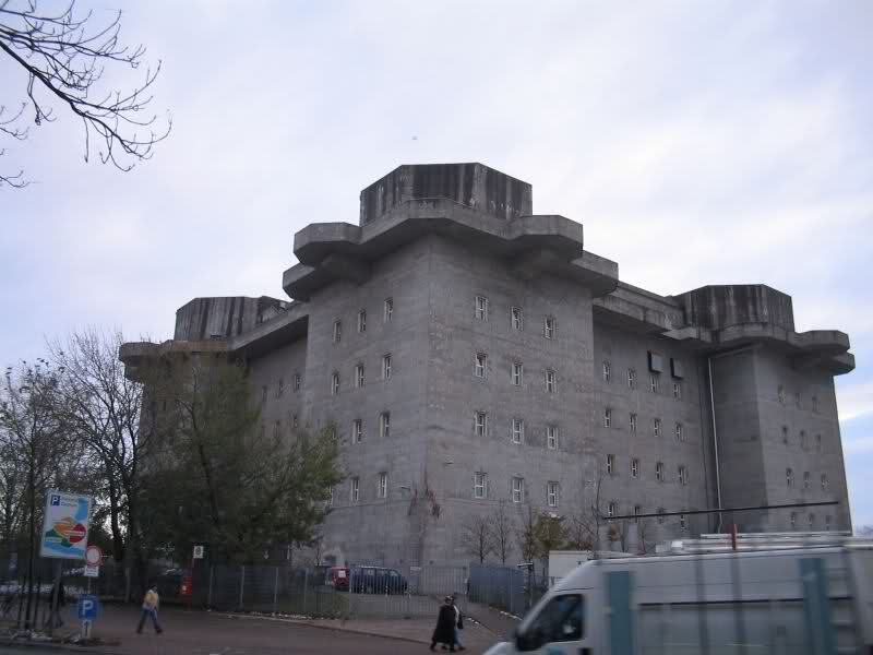
i recommend Shelters like we saw and still see in Nazi Germany,
they are relative cheap and very quick to build,
they offer a lot of Room and are well for multiple uses
such as Tsunamis, Wars and Godzilla Attacks
(the Tokyo-Kanagawa Coast inside of Tokyo Bay)
and Kamakura Area, they discussed the possibility of above 10m Tsunamis may happen soon,
similar Meeting will be hold the whole way down to Hiroshima!
They said the Nankai Line is so activo that "everything can happen"!
Imo. there is no Time and no Money to build Sea Walls and as we saw on 3/11
this protection is not 100% safe,
i recommend Shelters like we saw and still see in Nazi Germany,
they are relative cheap and very quick to build,
they offer a lot of Room and are well for multiple uses
such as Tsunamis, Wars and Godzilla Attacks
edit on 22-1-2012 by Human0815 because: spell
Japan Reviews Disaster Plan Amid New Quake Concerns
Underscoring the risks facing Japan, a new research institute investigation has determined there is a 70% chance of a magnitude-7 earthquake striking the Tokyo metropolitan area within the next four years, and 98% over 30 years. The March 2011 earthquake was a magnitude-9.
The latest prediction surprised residents, and grabbed headlines in the local media. The government's forecast, using a different methodology, has been that there is a 70% chance of a magnitude-7 quake hitting Tokyo over the next 30 years.
The term "within four years" began trending on Twitter early in the day, with users saying that while the threat of the big one hovered in the back of their minds, the new calculation has made them more aware of the need to make emergency preparations
Excellent Article!
since a few days our media is freaking out
and it seams like the big one is coming soon,
before the preparations are finished
and before Fukushima is cleaned of the sfp!
They expect the epicenter in the north of kantoplain!
Hmmm, not good at all, may the Gods have mercy!
and it seams like the big one is coming soon,
before the preparations are finished
and before Fukushima is cleaned of the sfp!
They expect the epicenter in the north of kantoplain!
Hmmm, not good at all, may the Gods have mercy!
reply to post by Human0815
Amen on that. It isn't Japan only that is suffering either because of the radioactivity from the March quake. The Tokoyo area is continually suffering earthquakes, and I'm not talking tiny. It's depressing news.
Amen on that. It isn't Japan only that is suffering either because of the radioactivity from the March quake. The Tokoyo area is continually suffering earthquakes, and I'm not talking tiny. It's depressing news.
Originally posted by Human0815
since a few days our media is freaking out
and it seams like the big one is coming soon,
before the preparations are finished
and before Fukushima is cleaned of the sfp!
They expect the epicenter in the north of kantoplain!
Hmmm, not good at all, may the Gods have mercy!
Yeah man, thanks for that report, and all the posts you have made. Every time you post I have no idea what to expect.
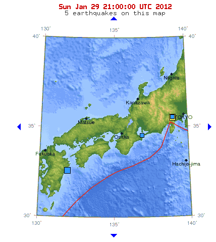
I have been watching Japan quakes very closely since the 7+.
And I have noticed that seismicity seems to be increasing too in the last week for some reason.
This latest one, right near a junction point, is making me a bit nervous:
earthquake.usgs.gov...
You can bet my seismos are up, and am monitoring them in near real time.
edit on Sat Jan 28th 2012 by TrueAmerican because: (no reason
given)
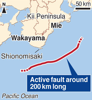
Active 200-km fault found off Honshu's Kii Peninsula
Previous shifts caused magnitude 8.6 quake, huge tsunami
If the fault on the Nankai Trough moves, it could trigger a magnitude 8.0 earthquake, the researchers said, adding they have found a seabed cliff several hundred meters high that was created by the fault's past movements. "There is a high probability that fault shifts have caused great tsunami," said Park Jin Oh, associate professor of marine geology.
"We need to reformulate disaster countermeasures by taking into account an active fault on the seabed 200 km or longer." Park analyzed sonar data on the seabed collected by the Japan Agency for Marine-Earth Science and Technology and found a fault branching off from a boundary between two tectonic plates in an area west of the southern tip of the Kii Peninsula in Wakayama Prefecture.
www.japantimes.co.jp...
Originally posted by Human0815
... they have found a seabed cliff several hundred meters high that was created by the fault's past movements. "There is a high probability that fault shifts have caused great tsunami," said Park Jin Oh, associate professor of marine geology.
Well I hope they study that new fault more and reach some kind of conclusion. That's like a thousand feet high, but it probably happened in smaller increments, over multiple quakes.
At least I darn well hope so. Cause if the fault moved only once or twice to create that high a ridge, the tsunami would have been hundreds of feet high. At least.
But check out the historical seismicity maps here:
neic.usgs.gov...
Lots of quakes have happened just since 1900, and hopefully have been relieving the stress. Problem is, the 9.1 may have changed all that and loaded that fault again. And you may be seeing the proof of that right here:
earthquake.usgs.gov...
edit on Sun Jan 29th 2012 by TrueAmerican because: (no reason
given)
reply to post by TrueAmerican
WOW.
7-8 METERS/year! Incredible. That almost makes the quakes they have seem like too few etc. for the conditions.
So, is the part that Tokyo sits on going under the part across the fault line? Or vice versa.
Sorry I'm so thick about this.
There looks to be a kind of angular part of a plate pointing West just South of Tokyo . . . is that point going over or under the plate it's pointing at?
Or, what do folks THINK is happening in such terms?
Greatly appreciate your kind, informative and patient response.
But it is generally accepted that the Pacific Plate is subducting under the "finger slice" part of the North American Plate that Tokyo is on. And this is what makes it so dangerous, as Tokyo sits on the upper lip of that subduction. In northern Japan near the Kurils, the rate is near 7 to 8 METERS per year. The rate is considerably less in the southern part of Japan, but still high. This makes northern Japan the most active seismic area, and at the most risk, of any other place on the planet.
WOW.
7-8 METERS/year! Incredible. That almost makes the quakes they have seem like too few etc. for the conditions.
So, is the part that Tokyo sits on going under the part across the fault line? Or vice versa.
Sorry I'm so thick about this.
There looks to be a kind of angular part of a plate pointing West just South of Tokyo . . . is that point going over or under the plate it's pointing at?
Or, what do folks THINK is happening in such terms?
Greatly appreciate your kind, informative and patient response.
Originally posted by BO XIAN
There looks to be a kind of angular part of a plate pointing West just South of Tokyo . . . is that point going over or under the plate it's pointing at?
Well technically, that southern boundary below Tokyo is classified as a transform fault, not a subduction fault.
I'm just not so sure about that, because of the Kanto quake and the resulting tsunami. If you study the epicenter location, it becomes more difficult to explain how the tsunami happened.
And really, it is more complicated than what I have explained as the Philippine Sea Plate is headed northwest, and supposedly sliding, along that same "transform" fault, as well. And then we also have another "proposed sub plate" in the Sea of Japan, to complicate matters even more.
But if you really want to know, start doing searches on google for "Japan Subduction" and things like that.
Here is an interesting link I found, with a map. Will help you understand, at least, what they THINK they know more recently, and even that map is not as complete as some others I have seen. There's lots out there about it, just gotta look.
records.viu.ca...
reply to post by TrueAmerican
I see said the blind man.
Thanks much for your kind explanations and the link.
I'll resort to
www.dogpile.com...
as you suggest.
For some reason, I usually prefer ATSer's quake threader's explanations more than those of the big boys. LOL.
You do a routinely excellent job on these threads and I greatly respect and appreciate that.
The Japan stuff is sure mystifying to me.
Then by the time one throws in all the conspiracy stuff . . . Wheeeee
Here is a pic of the Kuril-Kamchatka subduction zone, and surrounding plates & faults, with estimated relative plate velocities. Map originally found
here
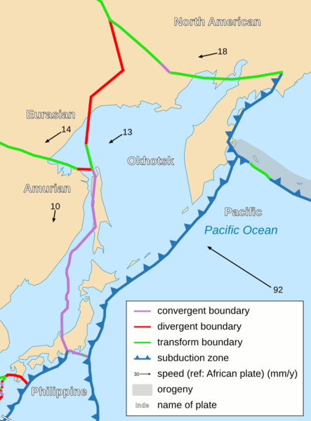
I believe its estimated subduction rate is 8-9 cm/year, or stated another way, 8-9 meters/century.
Tokyo's location is getting the squeeze for sure.
I believe its estimated subduction rate is 8-9 cm/year, or stated another way, 8-9 meters/century.
Tokyo's location is getting the squeeze for sure.
reply to post by Olivine
Yeah the Okhotsk plate is what I was thinking of, just couldn't remember the name. Not everyone agrees it even exists, as separate entity from the NA and EU plates. It's another one of those theories that is slowly gaining acceptance, and only recently have maps started even drawing it in.
Way down the road in the future, that plate may react to the 9.1 too. The Koreas, for example, could potentially get a triggered quake form this activity in Japan.
Originally posted by TrueAmerican
Way down the road in the future, that plate may react to the 9.1 too. The Koreas, for example, could potentially get a triggered quake form this activity in Japan.
Looks like it may already be starting to react:
Magnitude 4.4 - SEA OF JAPAN
earthquake.usgs.gov...
Map:
earthquake.usgs.gov...
Govt to review studies of possible massive Tokyo quake
The 340-kilometer Sagami Trough, also known as Sagami Trench or Sagami Megathrust, originates in the Japan Trench, which runs north to south about 200 kilometers off the coast of eastern Japan. Four or more tectonic plates are presumed to meet at the Sagami Trough and to have triggered massive earthquakes, including the 1923 Great Kanto Earthquake.
Stretching to Sagami Bay, Kanagawa Prefecture, by way of waters between the Izu Islands chain, Tokyo, and the Boso Peninsula, Chiba Prefecture, the Sagami Trough is believed to have caused magnitude-8-class earthquakes every 200 to 400 years.
A Sagami Trough-generated earthquake is expected to be markedly stronger than an earthquake focused just below the metropolitan area, which is expected to be no stronger than magnitude 7.
www.yomiuri.co.jp...
Too many Fault-line, Trenches and Megathrust's
Don`t think this was posted in here yet and thought it was relevant to this thread
www.youtube.com...
www.youtube.com...
Only 31 km E of Tokyo. Fortunately, it was of small-moderate magnitude and 59.9km deep.
Mag 4.8 details -USGS
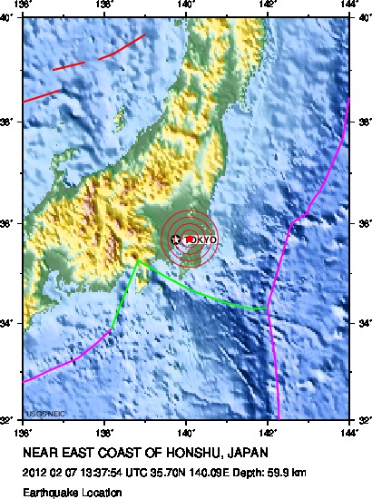
Creeping closer to the city--I don't like it.
Mag 4.8 details -USGS
Creeping closer to the city--I don't like it.
reply to post by Olivine
This one you mentioned was just a Bump and not really a Tremor,
just a Kick, deep but on a Place where we had already a few in the last Weeks!
But we stay Optimistic and remember that "Death is not the End"
This one you mentioned was just a Bump and not really a Tremor,
just a Kick, deep but on a Place where we had already a few in the last Weeks!
But we stay Optimistic and remember that "Death is not the End"
Making Waves
By many measures, the magnitude 9.0 earthquake that shook Japan a year ago was a record-breaker. It was the largest quake in the country’s written history, the trigger for the worst nuclear accident in 25 years and the costliest natural disaster ever.
Amid such superlatives, it’s easy to forget one more: During the Tohoku-oki quake, the seafloor off Japan’s coast wrenched itself farther apart than scientists had ever measured along any seafloor. In places, chunks of ground slipped horizontally past their neighbors by more than 50 meters and vertically by 10 meters. “The earthquake was a scofflaw,” says Emile Okal, a geophysicist at Northwestern University in Evanston, Ill. “It violated the scaling laws we’re used to.”
That deviant behavior is what made the quake so deadly, by producing a monster tsunami.
When the seafloor moves by half the length of a football field, it displaces an awful lot of water. Of the approximately 20,000 people who died on March 11, 2011, more than 90 percent drowned, were washed away or were otherwise killed by water.
So researchers have been studying what happened off Japan’s coast, seeking ways to better detect a lawless quake, track the resulting tsunami and ultimately save lives. Some of the work, based on survivor videos, reveals how quickly the deadly water surged into and then drained from coastal villages. Other research, looking at ancient sand deposits and boulders tossed like pebbles, suggests that Pacific-wide tsunamis like Tohoku-oki may be more common than once thought.
There’s some good news among the bad. The Japan tsunami was the earliest and best-detected monster wave ever, thanks to warning buoys set up globally after the 2004 Indian Ocean tsunami killed a quarter of a million people. With new findings from the Japan disaster and data from the global buoys, scientists in the United States are working to develop a forecast system that will in principle give people a better warning by predicting areas most likely to flood rather than the heights of incoming waves.
more to read, a highly interesting Article: www.sciencenews.org...
Another one near and dear:
USGS
Magnitude 4.8
Date-Time Friday, February 24, 2012 at 04:10:35 UTC Friday, February24,2012at 01:10:35PM at epicenter Time of Earthquakein otherTimeZones
Location 35.870°N, 139.874°E
Depth 75.8 km (47.1 miles)
Region NEAR THE SOUTHCOAST OF HONSHU,JAPAN
Distances 23 km (14 miles) NNE of TOKYO, Japan 51 km (31 miles) NNE of Yokohama, Honshu, Japan 76 km (47 miles) S of Utsunomiya, Honshu, Japan 78 km (48 miles) SW of Mito, Honshu, Japan
Location Uncertainty horizontal+/- 17km (10.6 miles);depth +/- 7.1km (4.4miles)
Parameters NST= 43, Nph= 45, Dmin=168.1 km, Rmss=0.93 sec, Gp=115°, M-type=body wave magnitude (Mb), Version=4
Source Magnitude: USGSNEIC (WDCS-D) Location: USGSNEIC (WDCS-D)
Event ID usb000857r
USGS
new topics
-
Supreme Court Oral Arguments 4.25.2024 - Are PRESIDENTS IMMUNE From Later Being Prosecuted.
Above Politics: 8 minutes ago -
Krystalnacht on today's most elite Universities?
Social Issues and Civil Unrest: 17 minutes ago -
Chris Christie Wishes Death Upon Trump and Ramaswamy
Politicians & People: 44 minutes ago -
University of Texas Instantly Shuts Down Anti Israel Protests
Education and Media: 2 hours ago -
Any one suspicious of fever promotions events, major investor Goldman Sachs card only.
The Gray Area: 5 hours ago -
God's Righteousness is Greater than Our Wrath
Religion, Faith, And Theology: 9 hours ago
top topics
-
VP's Secret Service agent brawls with other agents at Andrews
Mainstream News: 13 hours ago, 10 flags -
Cats Used as Live Bait to Train Ferocious Pitbulls in Illegal NYC Dogfighting
Social Issues and Civil Unrest: 17 hours ago, 8 flags -
Nearly 70% Of Americans Want Talks To End War In Ukraine
Political Issues: 14 hours ago, 5 flags -
Sunak spinning the sickness figures
Other Current Events: 14 hours ago, 5 flags -
Electrical tricks for saving money
Education and Media: 12 hours ago, 4 flags -
Late Night with the Devil - a really good unusual modern horror film.
Movies: 16 hours ago, 3 flags -
Krystalnacht on today's most elite Universities?
Social Issues and Civil Unrest: 17 minutes ago, 2 flags -
Any one suspicious of fever promotions events, major investor Goldman Sachs card only.
The Gray Area: 5 hours ago, 2 flags -
University of Texas Instantly Shuts Down Anti Israel Protests
Education and Media: 2 hours ago, 2 flags -
Supreme Court Oral Arguments 4.25.2024 - Are PRESIDENTS IMMUNE From Later Being Prosecuted.
Above Politics: 8 minutes ago, 1 flags
active topics
-
Nearly 70% Of Americans Want Talks To End War In Ukraine
Political Issues • 63 • : Consvoli -
University of Texas Instantly Shuts Down Anti Israel Protests
Education and Media • 35 • : CriticalStinker -
1980s Arcade
General Chit Chat • 27 • : alwaysbeenhere2 -
Skinwalker Ranch and the Mystery 1.6GHz Signal
Aliens and UFOs • 143 • : Ophiuchus1 -
"We're All Hamas" Heard at Columbia University Protests
Social Issues and Civil Unrest • 281 • : marg6043 -
I Guess Cloud Seeding Works
Fragile Earth • 42 • : WaESN -
Supreme Court Oral Arguments 4.25.2024 - Are PRESIDENTS IMMUNE From Later Being Prosecuted.
Above Politics • 0 • : WeMustCare -
D.C. Court of Appeals made a horrible ruling against Trump
US Political Madness • 320 • : WeMustCare -
Krystalnacht on today's most elite Universities?
Social Issues and Civil Unrest • 1 • : FlyersFan -
New whistleblower Jason Sands speaks on Twitter Spaces last night.
Aliens and UFOs • 58 • : Ophiuchus1