It looks like you're using an Ad Blocker.
Please white-list or disable AboveTopSecret.com in your ad-blocking tool.
Thank you.
Some features of ATS will be disabled while you continue to use an ad-blocker.

Japan Tsunami: full disaster extand maps from TerraSarX satellite
page: 14
share:
The Center for Satellite Based Crisis Information (ZKI) presents a service of the German Remote Sensing Data Center (DFD) of DLR. It provides a 24/7
service for the rapid provision, processing and analysis of satellite imagery during natural and environmental disasters, for humanitarian relief
activities and civil security issues worldwide. The resulting satellite based information products are provided to relief organisations and public
authorities and are also freely available on the ZKI website.
ZKI Mission
Apart from the downloadable maps, ZKI also provides an interactive web mapping component showing selected satellite imagery, making it possible to compare pre- and post disaster images. As work progresses, more interactive images will become available.
Full maps view
Low and medium maps resolution are avalaible to download above for free as well as KMZ files.
Samples:
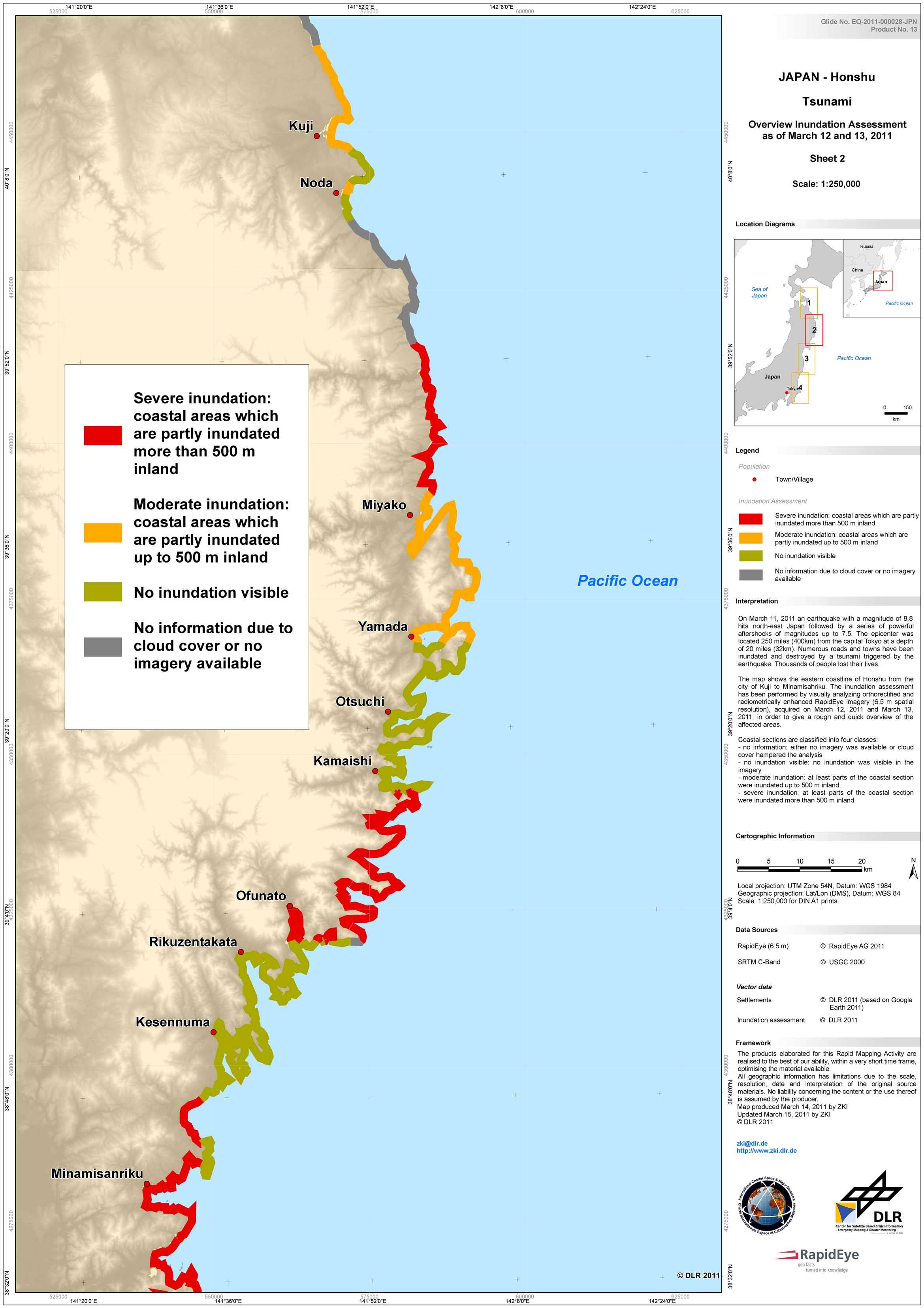
Observed inundation extend

Overview inundation assessment
ZKI Mission
Apart from the downloadable maps, ZKI also provides an interactive web mapping component showing selected satellite imagery, making it possible to compare pre- and post disaster images. As work progresses, more interactive images will become available.
Full maps view
Low and medium maps resolution are avalaible to download above for free as well as KMZ files.
Samples:
Observed inundation extend
Overview inundation assessment
new topics
-
Ditching physical money
History: 1 hours ago -
One Flame Throwing Robot Dog for Christmas Please!
Weaponry: 1 hours ago -
Don't take advantage of people just because it seems easy it will backfire
Rant: 1 hours ago -
VirginOfGrand says hello
Introductions: 2 hours ago -
Should Biden Replace Harris With AOC On the 2024 Democrat Ticket?
2024 Elections: 3 hours ago -
University student disciplined after saying veganism is wrong and gender fluidity is stupid
Education and Media: 5 hours ago -
Geddy Lee in Conversation with Alex Lifeson - My Effin’ Life
People: 6 hours ago -
God lived as a Devil Dog.
Short Stories: 7 hours ago -
Police clash with St George’s Day protesters at central London rally
Social Issues and Civil Unrest: 8 hours ago -
TLDR post about ATS and why I love it and hope we all stay together somewhere
General Chit Chat: 9 hours ago
4