It looks like you're using an Ad Blocker.
Please white-list or disable AboveTopSecret.com in your ad-blocking tool.
Thank you.
Some features of ATS will be disabled while you continue to use an ad-blocker.

Chemtrails/Contrails over my town.
page: 2share:
reply to post by djcarlosa
At least they're debunkers and not the trolls & flamers that usually attack all my posts on here. If people can provide a good argument for either side of something I am always willing to listen to what they have to say.
At least they're debunkers and not the trolls & flamers that usually attack all my posts on here. If people can provide a good argument for either side of something I am always willing to listen to what they have to say.
I live in Phoenix, AZ USA and I've been noticing a huge increase in the number of "contrails". I put contrails in quotes because that's what they
want us to believe.
I've been in Phoenix for about 7 years and in all my life I have never seen more clear, blue skies than I have here...until recently. There are a couple things I would like to point out to all the debunkers.
First of all, a normal contrail doesn't spread across the sky and create a stratus cloud than lingers for hours. Secondly, those are high altitude aircraft. They are not free to fly wherever they choose. Commercial aircraft follow prescribed air routes. They navigate between ground based "nav-aids". When you see multiple, high-altitude aircraft, all criss-crossing in a random pattern, they certainly are NOT commercial airliners following a flight plan.
The last couple weeks, the skies around Phoenix have started the day crystal clear, as you would expect in AZ. Then come the chemtrails. Within an hour or two, the skies are covered in a thin, stratus-type cloud with chemtrails all over the place.
I'm going to try to get better pictures but this is just one small example of what I see daily. These clouds were NOT there prior to aircraft flying through and leaving their chemicals.

Looking at this picture, please note, there are NOT jet routes all crowded that close together. Furthermore, they are criss-crossing at random. Generally, when you see multiple, semi-parallel contrails in the sky, they will converge on a common point, a ground-based nav-aid.
Finally, I can clearly see aircraft arriving and departing Phoenix-Sky Harbor Int'l Airport. Those aircraft NEVER leave a contrail. You have to have moisture in order to leave a contrail or in order for clouds to form. Our relative humidity can be as low as 5% during non-monsoon, therefore there isn't anything for clouds to form with.
I've included a high-altitude jet route for Arizona for reference. As you can clearly see, you don't have paths criss-crossing each other. Draw your own conclusions...

I've been in Phoenix for about 7 years and in all my life I have never seen more clear, blue skies than I have here...until recently. There are a couple things I would like to point out to all the debunkers.
First of all, a normal contrail doesn't spread across the sky and create a stratus cloud than lingers for hours. Secondly, those are high altitude aircraft. They are not free to fly wherever they choose. Commercial aircraft follow prescribed air routes. They navigate between ground based "nav-aids". When you see multiple, high-altitude aircraft, all criss-crossing in a random pattern, they certainly are NOT commercial airliners following a flight plan.
The last couple weeks, the skies around Phoenix have started the day crystal clear, as you would expect in AZ. Then come the chemtrails. Within an hour or two, the skies are covered in a thin, stratus-type cloud with chemtrails all over the place.
I'm going to try to get better pictures but this is just one small example of what I see daily. These clouds were NOT there prior to aircraft flying through and leaving their chemicals.
Looking at this picture, please note, there are NOT jet routes all crowded that close together. Furthermore, they are criss-crossing at random. Generally, when you see multiple, semi-parallel contrails in the sky, they will converge on a common point, a ground-based nav-aid.
Finally, I can clearly see aircraft arriving and departing Phoenix-Sky Harbor Int'l Airport. Those aircraft NEVER leave a contrail. You have to have moisture in order to leave a contrail or in order for clouds to form. Our relative humidity can be as low as 5% during non-monsoon, therefore there isn't anything for clouds to form with.
I've included a high-altitude jet route for Arizona for reference. As you can clearly see, you don't have paths criss-crossing each other. Draw your own conclusions...
reply to post by djcarlosa
Thanks for the reply. Back when you first announced that you intended to upload your 'chemtrail' videos I checked out your You Tube Channel. Obviously you haven't done so then, but it is quite clear the shire that you live in from one of the videos that you posted. That pedestrian shopping area featured is easily recognisable. It is OK I won't reveal the city online.
You live near Upper Air Route UN14. Contrary to what you reveal UN14 is a busy east-west/west-east. This covers regional and transatlantic flights and not just Heathrow-Dublin. How do you think
flights route from Paris to Dublin? These routes are around 10 nautical miles wide. Think how many aircraft that you can fit into a corrider 10 nautical miles wide?
See following link for
UPPER AIRSPACE CONTROL AREA AND UPPER ATS (Air Traffic Services)ROUTES (South Sheet)
www.ead.eurocontrol.int...< br />
Note UN14.
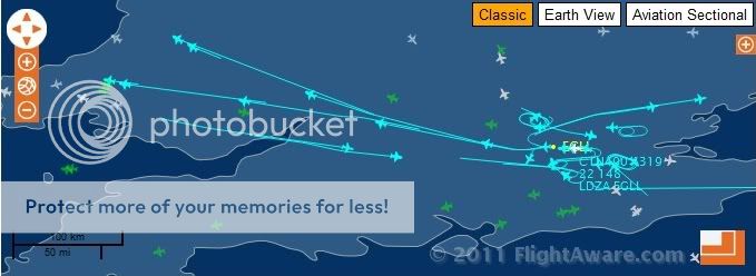
The following is a Flight Aware screen capture from earlier today. You can see how busy UN14 is even on a Sunday with transatlantic traffic.
That UN14 air traffic when the conditions are right for contrails will produce videos and images such as the following. Note the person refers to them as 'Chemtrails'. No doubt the same type of images that you are taking?
www.checktheevidence.co.uk...
Contrary to what you believe aircraft at contrail producing heights also cross Upper Air Route UN14. For example some airliners flying out of Birmingham International are routed to a waypoint in your shire. For example waypoint MOSUN coordinates 51 53 38N 02 26 10W
MOSUN coordintates at following.
www.ead.eurocontrol.int...
Map showing MOSUN waypoint.
ivao.co.uk...
Crossing such air routes is covered in the following.
CAP 493 Manual of Air Traffic Services Part 1
www.caa.co.uk...
An example of this is a Boeing 767 from Birmingham noted today crossing UN14 and using the waypoints within the shire on its way to the Dominican Republic.
flightaware.com...
In addition to civilian aircraft there are also military aircraft that cross upper air routes. The RAF Eurofighter Typhoon in particular can transit above the airliner traffic and routinely do so in order to get to UK military training areas.
Flt Lt Tim Clement, an RAF Typhoon Pilot, reveals in interview.
From
www.globalaviationresource.com...
A snapshot of the traffic as seen in the Flight Aware screen capture using Upper Air Route UN14.
Flight AAL87
Boeing 777
flightaware.com...
Route using UN14 after taking off from London Heathrow bound for Chicago.
Flight AAL57
Boeing 777
flightaware.com...
Route using UN14 after taking off from London Heathrow bound for Miami.
Flight BAW207
Boeing 747
flightaware.com...
Route using UN14 after taking off from London Heathrow bound for Miami.
Flight VIR3
Airbus A340
flightaware.com...
Route using UN14 after taking off from London Heathrow bound for New York.
So in your vicinity there is a busy air route and waypoint. Aircraft can transit through the waypoint and above the Upper Air Route and not just in one direction. The Upper Air Routes can be 10nm
wide with aircraft and trails crossing over each other. If the conditions favour persistent contrails then what you will see are grid and x-patterns as you can see in the video and still links posted.
I've just checked back and noted your video. It is classic chemtrail jibberish. Everything contained in it. The Sun, cloudseeding and now you can taste it?
Your video
You are the one originally stating that only the Heathrow-Dublin flight passes over you location. This is clearly not correct as Upper Air Route UN14 passes your location. A busy, busy air route that you can follow and track on Flight Aware. Sorry, epic fail on your video. You clearly haven't been honest in your description or you simply were not aware of the Upper Air Route above you?
TJ
Thanks for the reply. Back when you first announced that you intended to upload your 'chemtrail' videos I checked out your You Tube Channel. Obviously you haven't done so then, but it is quite clear the shire that you live in from one of the videos that you posted. That pedestrian shopping area featured is easily recognisable. It is OK I won't reveal the city online.
You live near Upper Air Route UN14. Contrary to what you reveal UN14 is a busy east-west/west-east. This covers regional and transatlantic flights and not just Heathrow-Dublin. How do you think
flights route from Paris to Dublin? These routes are around 10 nautical miles wide. Think how many aircraft that you can fit into a corrider 10 nautical miles wide?
See following link for
UPPER AIRSPACE CONTROL AREA AND UPPER ATS (Air Traffic Services)ROUTES (South Sheet)
www.ead.eurocontrol.int...< br />
Note UN14.
The following is a Flight Aware screen capture from earlier today. You can see how busy UN14 is even on a Sunday with transatlantic traffic.
That UN14 air traffic when the conditions are right for contrails will produce videos and images such as the following. Note the person refers to them as 'Chemtrails'. No doubt the same type of images that you are taking?
www.checktheevidence.co.uk...
Contrary to what you believe aircraft at contrail producing heights also cross Upper Air Route UN14. For example some airliners flying out of Birmingham International are routed to a waypoint in your shire. For example waypoint MOSUN coordinates 51 53 38N 02 26 10W
MOSUN coordintates at following.
www.ead.eurocontrol.int...
Map showing MOSUN waypoint.
ivao.co.uk...
Crossing such air routes is covered in the following.
CAP 493 Manual of Air Traffic Services Part 1
www.caa.co.uk...
An example of this is a Boeing 767 from Birmingham noted today crossing UN14 and using the waypoints within the shire on its way to the Dominican Republic.
flightaware.com...
In addition to civilian aircraft there are also military aircraft that cross upper air routes. The RAF Eurofighter Typhoon in particular can transit above the airliner traffic and routinely do so in order to get to UK military training areas.
Flt Lt Tim Clement, an RAF Typhoon Pilot, reveals in interview.
"Equally, we usually transit across the UK at 40,000ft+, which means we are above all the airway traffic and can reach anywhere by taking a direct route, so this is both quick and efficient. The trick though is coming down from altitude as, if we select idle and point the aircraft five degrees nose down, we will still go supersonic. "We have to roll the aircraft inverted and pull back hard on the stick to unload all the energy and can then spiral downwards without breaking the sound barrier."
From
www.globalaviationresource.com...
A snapshot of the traffic as seen in the Flight Aware screen capture using Upper Air Route UN14.
Flight AAL87
Boeing 777
flightaware.com...
Route using UN14 after taking off from London Heathrow bound for Chicago.
Flight AAL57
Boeing 777
flightaware.com...
Route using UN14 after taking off from London Heathrow bound for Miami.
Flight BAW207
Boeing 747
flightaware.com...
Route using UN14 after taking off from London Heathrow bound for Miami.
Flight VIR3
Airbus A340
flightaware.com...
Route using UN14 after taking off from London Heathrow bound for New York.
So in your vicinity there is a busy air route and waypoint. Aircraft can transit through the waypoint and above the Upper Air Route and not just in one direction. The Upper Air Routes can be 10nm
wide with aircraft and trails crossing over each other. If the conditions favour persistent contrails then what you will see are grid and x-patterns as you can see in the video and still links posted.
I've just checked back and noted your video. It is classic chemtrail jibberish. Everything contained in it. The Sun, cloudseeding and now you can taste it?
Your video
You are the one originally stating that only the Heathrow-Dublin flight passes over you location. This is clearly not correct as Upper Air Route UN14 passes your location. A busy, busy air route that you can follow and track on Flight Aware. Sorry, epic fail on your video. You clearly haven't been honest in your description or you simply were not aware of the Upper Air Route above you?
TJ
reply to post by tommyjo
you watched my vid and in reply you posted the air routes you showed me where the clear line going over which is the flight path going over my house but if you watch the vid you can see that theses planes are criss crossing in the sky not following the strait route your pic shows so in a way you are proving what I am showing you is not normal planes on there normal plane routes.
you watched my vid and in reply you posted the air routes you showed me where the clear line going over which is the flight path going over my house but if you watch the vid you can see that theses planes are criss crossing in the sky not following the strait route your pic shows so in a way you are proving what I am showing you is not normal planes on there normal plane routes.
reply to post by djcarlosa
I don't have the aeronatautical knowledge Tommyjo has - but I'm sure he can tell us what the air flight corridor those north-south flights between N England, Scotland and Spain - which goes directly over where you live - is called.
Given E-W and N-S flights, a criss cross pattern seems inevitable does it not?
reply to post by General.Lee
Brilliant post my friend one you should add to the other chem trail threads as i have seen that not one of the attack pack have commented or attacked your post well thought out and it's exactly what i am seeing on every hot clear day untill the clouds start to form i have stared you good work my friend i just hope that you post in the other threads help us win through with the truth
Brilliant post my friend one you should add to the other chem trail threads as i have seen that not one of the attack pack have commented or attacked your post well thought out and it's exactly what i am seeing on every hot clear day untill the clouds start to form i have stared you good work my friend i just hope that you post in the other threads help us win through with the truth
Originally posted by General.Lee
Finally, I can clearly see aircraft arriving and departing Phoenix-Sky Harbor Int'l Airport. Those aircraft NEVER leave a contrail.
Well no, because they're at a lower altitude - it;s the aircraft passing overhead en route to/from airports hundred or thousands of miles away that eave contrails
I've included a high-altitude jet route for Arizona for reference. As you can clearly see, you don't have paths criss-crossing each other. Draw your own conclusions...
I can clearly see that they DO have paths criss-crossing each other
You know its great that a subject that has become a hoax or skunk work issue still has so many members that spend so much time on this subject pack
attacking those of us who can see what's going on up in the sky in case this subject becomes mainstream.
The funny thing here is that all the members who comment on this are rather educated in certain fields makes me think that why would these educated smart people Have the time and energy to sit at there pc's discrediting a subject they believe to be complete rubbish.
I myself wouldn't waste time and effort if I believe that a subject has no merit and you out there [you know who I'm talking to]seam to be kinda stupid for smart people why bother, spend your time on subjects you do believe in.
Unfortunately unlike most of the population[sheep] I still have the ability to see what is going on around me I can tell when things change and I still have the ability to question what I am told and not swallow it wholesale.
Thankfully I see many members here who are the same as me over the next year you will see that number rise and the harder you try to make us shut up the louder we will become.
reply to post by djcarlosa
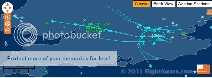
So how do you explain the airliner that came out of Birmingham? It passed the waypoint MOSUN on its way south.
flightaware.com...
www.opennav.com...
Just copy and paste the following into a search engine to see other Birmingham flights using that route.
'egbb mosun flightaware'
EGBB is the code for Birmingham International. Some transatlantic flights use that waypoint in Gloucestershire when flying out of and into Birmingham.
Military aircraft can also pass over Upper Air Routes. Did you not read in my reply about the RAF Typhoon? These aircraft are at heights that produce contrails, so obviously if persistent they will criss cross and form shapes. What is so hard to understand about that? You are under the assumption that the aircraft can only go one way east-west or west-east.
So there you have the facts. UN14 is the main route and aircraft can pass over waypoints and fly above that route (UN14). Military and Civil aircraft have to share busy UK airspace. So you now know that in the area where you live you will see criss cross patterns/grids as aircraft produce contrails.
TJ
edit on 14-3-2011 by tommyjo because: spelling
reply to post by tommyjo
Strange how you should mention the RAF who until 4 month's ago used this area to train for attack runs in both tornadoes and harriers low flying runs etc.
Now we haven't seen RAF jets at all in the last 4 months .
now I see these planes with there unusual trails flying criss cross the sky's maybe the RAF can't fly here any more due to these new plane routes that don't show up on sites tracking planes etc.
We were an ideal place for them to train because of the low air traffic in this area now we don't see them.
Also in reply to your I know which city you live in I do not live in a city but a town some miles from the city in question
edit on 14-3-2011 by djcarlosa because: added info
Originally posted by djcarlosa
reply to post by tommyjo
Strange how you should mention the RAF who until 4 month's ago used this area to train for attack runs in both tornadoes and harriers low flying runs etc.
I think a lot more low level training flights take place over the Brecon Beacons, for example, but nontheless, as you say, these are low level - miles below commercial air paths.
We were an ideal place for them to train because of the low air traffic in this area now we don't see them.
You have high levels of commerical air traffic - several dozen an hour at the least - as do I. Denying it won't change things. But just think, some of those contrails overhead are left by Geordies en route to the Canaries for a fortnight's holiday, can we blame them?
reply to post by Essan
I'm not denying that I have a fair amount of air traffic on the route that passes over the top of my house all through last summer in an hour I must have seen 13 high flying commercial jet's fly over on that route but the trails they left dissipated within a 2 min's but what I never saw was planes crisscrossing in a lattice like pattern across the sky also another point I would like to make is those planes I watched last summer all went overhead in the same direction non came back the same way it was a 1 direction route outbound traffic only which would make sense if they where heading to Dublin.
Now what I'm seeing is not the same as last summer planes criss crossing going left to right right to left all at the same time so that there trails all cross over one another and once the sky clouds over it goes back to normal planes following the same route as before then as the sky becomes clearish by lunch time back come the other planes crisscrossing once again.and like before clouds begin to form across the sky looking like a wave of mist floating across the sky.
the difference in the trails is so apparent that even my son has asked me what they are. .
Ok just clear one point up for me here before I carry on you all agree that what I am seeing from the ground is normal contrails left because of
weather conditions formed by the exhaust made by the jet engines on normal commercial planes is that right?
Originally posted by djcarlosa
Ok just clear one point up for me here before I carry on you all agree that what I am seeing from the ground is normal contrails left because of weather conditions formed by the exhaust made by the jet engines on normal commercial planes is that right?
asd-www.larc.nasa.gov...
en.wikipedia.org...
TJ
reply to post by djcarlosa
You live in an area covered by Low Flying Area 02 and 04. You will see RAF, USAF and other NATO aircraft on transit to Low Flying Area 07 and Low Flying Area 02.
www.mod.uk...
www.mod.uk...
www.mod.uk...
Firstly a number of RAF and Royal Navy aircraft types have retired from service since your observations. The Harrier is gone, The Dominie is gone. The Harrier GR7/9 and T.10/12 as used by the RAF and Royal Navy (Fleet Air Arm) were retired from service in December 2010. Common sense dictates that with two types routinely seen at low level retired the amount of low level operations is going to decline.
You are still failing to understand that the Upper Air Route above you are nothing new. It has been there for years. How do you think some transatlantic airliners route out of and into Heathrow on their way to the US? Types such as Tornado, Harrier etc will route below the upper air routes. The upper air routes will have no effect on any aircraft transiting below this level. Aircraft such as RAF Eurofighter Typhoon and USAF F-15 Eagle have the performance if they want to transit to low flying and exercise areas above the upper air routes.
The airliners are up there at cruising height for a reason. That is the most efficient place for them to be in regards to fuel. Those Pilots flying high performance fighters have that option if they choose to use it to get above busy skies filled with airliners in the UK. For example an RAF Typhoon can take off from RAF Coningsby in Lincolnshire zoom climb and transit at 40,000 feet plus above all the airliners and then let down over Wales to enter Low Flying Area 07.
www.mod.uk...
Since retiring from the RAF I have more time for aviation photography. My passion is low level photography of military aircraft flying through the mountains and hills in Wales,
Scotland and the Lake District. Looking through my archives I have two record shots of RAF Eurofigher Typhoons pictured over Wales from 2008. These two Typhoons were operating at 41,000 feet above the mountain that I was standing on in Wales. Most low level photographers have an airband scanner radio to keep track of aircraft in the vicinity.
Images of RAF Typhoons at 41,000 feet over Wales producing contrails.


Just to prove that I'm not spinning you a story these are some of my low level images from the hills in Wales - Low Flying Area 07.
www.airliners.net...
www.airliners.net...
www.airliners.net...
www.airliners.net...
With all due respect you have stumbled across 'chemtrails' and thus the world of aviation. Consequently you are seeing aviation through the eyes of someone with no real understanding of it. This is quite clear when you are saying that those routes above you are new. This couldn't be further from the truth. This clear lack of Air Traffic Control and aviation knowledge is why some people are taking their time and going out of their way to explain to you what you are seeing. You are trying to interpret what you are seeing from a layman's perception.
Have a look at the following.
www.nats.co.uk...
From
www.nats.co.uk...
See map of UK controlled airspace. Note the route going over your area? This has been there for years and hasn't just appeared since you have been observing the skies.
This is a map of Civil Airways from 1964.
From
www.winkton.net...
Aircraft have been routing in and out of North America, UK and Europe above you for a very long time.
A modern map shown in the following.
jon-hall.co.uk...
www.avsim.com...
The likes of Plane Plotter can be downloaded. This will cover military and civilian aircraft. It is a more comprehensive way to monitor air traffic. Remember that many thousands of people do this as a hobby.
www.coaa.co.uk...
TJ
You live in an area covered by Low Flying Area 02 and 04. You will see RAF, USAF and other NATO aircraft on transit to Low Flying Area 07 and Low Flying Area 02.
www.mod.uk...
www.mod.uk...
www.mod.uk...
Firstly a number of RAF and Royal Navy aircraft types have retired from service since your observations. The Harrier is gone, The Dominie is gone. The Harrier GR7/9 and T.10/12 as used by the RAF and Royal Navy (Fleet Air Arm) were retired from service in December 2010. Common sense dictates that with two types routinely seen at low level retired the amount of low level operations is going to decline.
You are still failing to understand that the Upper Air Route above you are nothing new. It has been there for years. How do you think some transatlantic airliners route out of and into Heathrow on their way to the US? Types such as Tornado, Harrier etc will route below the upper air routes. The upper air routes will have no effect on any aircraft transiting below this level. Aircraft such as RAF Eurofighter Typhoon and USAF F-15 Eagle have the performance if they want to transit to low flying and exercise areas above the upper air routes.
The airliners are up there at cruising height for a reason. That is the most efficient place for them to be in regards to fuel. Those Pilots flying high performance fighters have that option if they choose to use it to get above busy skies filled with airliners in the UK. For example an RAF Typhoon can take off from RAF Coningsby in Lincolnshire zoom climb and transit at 40,000 feet plus above all the airliners and then let down over Wales to enter Low Flying Area 07.
www.mod.uk...
Since retiring from the RAF I have more time for aviation photography. My passion is low level photography of military aircraft flying through the mountains and hills in Wales,
Scotland and the Lake District. Looking through my archives I have two record shots of RAF Eurofigher Typhoons pictured over Wales from 2008. These two Typhoons were operating at 41,000 feet above the mountain that I was standing on in Wales. Most low level photographers have an airband scanner radio to keep track of aircraft in the vicinity.
Images of RAF Typhoons at 41,000 feet over Wales producing contrails.
Just to prove that I'm not spinning you a story these are some of my low level images from the hills in Wales - Low Flying Area 07.
www.airliners.net...
www.airliners.net...
www.airliners.net...
www.airliners.net...
With all due respect you have stumbled across 'chemtrails' and thus the world of aviation. Consequently you are seeing aviation through the eyes of someone with no real understanding of it. This is quite clear when you are saying that those routes above you are new. This couldn't be further from the truth. This clear lack of Air Traffic Control and aviation knowledge is why some people are taking their time and going out of their way to explain to you what you are seeing. You are trying to interpret what you are seeing from a layman's perception.
Have a look at the following.
www.nats.co.uk...
From
www.nats.co.uk...
See map of UK controlled airspace. Note the route going over your area? This has been there for years and hasn't just appeared since you have been observing the skies.
This is a map of Civil Airways from 1964.
From
www.winkton.net...
Aircraft have been routing in and out of North America, UK and Europe above you for a very long time.
A modern map shown in the following.
jon-hall.co.uk...
www.avsim.com...
The likes of Plane Plotter can be downloaded. This will cover military and civilian aircraft. It is a more comprehensive way to monitor air traffic. Remember that many thousands of people do this as a hobby.
www.coaa.co.uk...
TJ
edit on 15-3-2011 by tommyjo because: Malformed link corrected
Thanks for all the replies, sorry I didn't post anything on this thread yesterday or the day before, we've been busy getting the garden ready for
summer.
I've got some more pictures of some really weird looking stratus clouds, which I really think are the result of these 'trails' I've got to nip out shopping but I will upload them later today so you can see.
My mum always used to tell me that jet plane vapor trails don't stay in the sky because the sun evaporates them like it does the clouds when it gets hot enough. This is why we get cloudless summer days. These plane trails however don't evaporate, the linger in the sky ALL DAY, getting bigger and bigger, until they form clouds.
What I should do if I have time one day, is to take a photo of them every hour or so, as they grow, and post them here, that would be interesting.
Originally posted by The Chez
I've got some more pictures of some really weird looking stratus clouds, which I really think are the result of these 'trails'
Contrails only produce cirrus - stratus is a much lower level cloud. Be nice to see the the picture though
btw anyone notice the classic frontal clearance today - early morning cirrus (natural and aircraft made) ahead of the front, but none in the drier upper air that's come behind it.
new topics
-
Has Tesla manipulated data logs to cover up auto pilot crash?
Automotive Discussion: 34 minutes ago -
whistleblower Captain Bill Uhouse on the Kingman UFO recovery
Aliens and UFOs: 5 hours ago -
1980s Arcade
General Chit Chat: 7 hours ago -
Deadpool and Wolverine
Movies: 8 hours ago -
Teenager makes chess history becoming the youngest challenger for the world championship crown
Other Current Events: 9 hours ago -
CIA botched its handling of sexual assault allegations, House intel report says
Breaking Alternative News: 10 hours ago
top topics
-
Lawsuit Seeks to ‘Ban the Jab’ in Florida
Diseases and Pandemics: 12 hours ago, 20 flags -
Starburst galaxy M82 - Webb Vs Hubble
Space Exploration: 14 hours ago, 13 flags -
The Superstition of Full Moons Filling Hospitals Turns Out To Be True!
Medical Issues & Conspiracies: 16 hours ago, 8 flags -
CIA botched its handling of sexual assault allegations, House intel report says
Breaking Alternative News: 10 hours ago, 8 flags -
15 Unhealthiest Sodas On The Market
Health & Wellness: 15 hours ago, 6 flags -
whistleblower Captain Bill Uhouse on the Kingman UFO recovery
Aliens and UFOs: 5 hours ago, 6 flags -
1980s Arcade
General Chit Chat: 7 hours ago, 4 flags -
Deadpool and Wolverine
Movies: 8 hours ago, 3 flags -
Teenager makes chess history becoming the youngest challenger for the world championship crown
Other Current Events: 9 hours ago, 3 flags -
Has Tesla manipulated data logs to cover up auto pilot crash?
Automotive Discussion: 34 minutes ago, 0 flags
active topics
-
15 Unhealthiest Sodas On The Market
Health & Wellness • 36 • : tanstaafl -
My wife just had a very powerful prophetic dream - massive war in Israel...
The Gray Area • 12 • : SchrodingersRat -
-@TH3WH17ERABB17- -Q- ---TIME TO SHOW THE WORLD--- -Part- --44--
Dissecting Disinformation • 606 • : burritocat -
"We're All Hamas" Heard at Columbia University Protests
Social Issues and Civil Unrest • 199 • : FlyersFan -
It takes One to Be; Two to Tango; Three to Create.
Philosophy and Metaphysics • 7 • : Terpene -
Take it to the Media when you protest.. Don't let them ignore you!
Education and Media • 4 • : SchrodingersRat -
They Killed Dr. Who for Good
Rant • 62 • : FlyersFan -
Has Tesla manipulated data logs to cover up auto pilot crash?
Automotive Discussion • 0 • : Cavemannick -
Lawsuit Seeks to ‘Ban the Jab’ in Florida
Diseases and Pandemics • 22 • : Disgusted123 -
Definitive 9.11 Pentagon EVIDENCE.
9/11 Conspiracies • 421 • : Lazy88