It looks like you're using an Ad Blocker.
Please white-list or disable AboveTopSecret.com in your ad-blocking tool.
Thank you.
Some features of ATS will be disabled while you continue to use an ad-blocker.

Stratospheric Aerosol Geo-engineering aka "Chemtrails" DEBUNK THIS !!!!
page: 19share:
reply to post by ZombieJesus
Firstly i said they where similar and my point is still valid as in order to create the smoke effect you have to spray the diesel in to the exhaust.
Thankyou for the information you gave though as I was not aware of how they did it but I was not saying that these trails where the same as just similar to so wouldn't it make sense that they may be sprayed hence why they look alike.
reply to post by Soylent Green Is People
Yes a flight route may have several lanes but they will all still follow the same route so if I say that they go over my house going in the same direction [say behind over and forward ] then why would I see planes on a sunny day going left to right,right to left so that there trails criss cross in the sky.
As I said I live in one of the few areas of the UK that dose not have alot of air traffic going over so as I said just the one route goes over where I live so no matter what people say I know this is recent and is not normal.
Originally posted by djcarlosa
reply to post by Soylent Green Is People
Yes a flight route may have several lanes but they will all still follow the same route so if I say that they go over my house going in the same direction [say behind over and forward ] then why would I see planes on a sunny day going left to right,right to left so that there trails criss cross in the sky.
As I said I live in one of the few areas of the UK that dose not have alot of air traffic going over so as I said just the one route goes over where I live so no matter what people say I know this is recent and is not normal.
Where do you live? Most of the UK sees some of the 7,000 aircraft flying over us ever day, flying north south and east west.
I'm not aware of anywhere where air traffic would ony go in one direction? The Shetlands perhaps?
For reference:
contrailscience.com...
edit on 12-3-2011 by Essan because: (no reason given)
reply to post by djcarlosa
?????
Explain....you said I posted a "site" showing "only the one route". Are you talking about the video, or the "FlightRadar24" website?? Here in the States, I have ready access online to Aeronautical Charts....I will look to see if there is a link to something similar in the UK.
The video was a time-lapse compilation of 24-hours' worth of flights.... and there is no way you will convince me that you live somewhere on that tiny island nation that only has ONE airplane per day overhead!! It will take more time for you to sit and observe on the live tracker website. However, THAT site will be useful as you determine the airplanes that are actually making the contrails.
This morning I woke up, and after some weather changes from overnight, and the day before....today dawned mostly cloudless....but, a LOT of well-defined contrails were apparent already, by 07:00. They were exactly where I expect them, mostly along Jet Airways J-75, J-48 and J-51 ....those run roughly parallel, and separated by roughly 20 to 30 miles. They are major routes for the East Coast of the USA....running from NorthEast/SouthWest.
Of course, there were multiple contrails because of the many airplanes that had passed by, and were in process of going by, overhead. All at various altitudes, and after some time, the older contrails had drifted on the winds, so they had a "not directly aligned" over each other appearance, but slight offsets, depending on what time each was formed, and then blew with the breeze.
This is my first crappy attempt to screen-shot from that website "SkyVector" (link below):
I am right near the Washington National Airport....you can see its VOR on the Chart. You can see the ARMEL and NOTTINGHAM VORs to the west, and slightly east/southeast respectively...and the Airway number designaitons I mentioned. (Among with MANY other Airways as depicted).
GO TO www.skyvector.com... and use the menus, you can find that same chart online, and interact with it.
Mouse over the globe icon, for "Charts"....then click on the area of the country, and you can open "Enroute H-12". It is conveniently angled, for the use by pilots on north/south directions of travel....also, the others repeat the same info, just oriented more east/west. ("Enroute H-10" also covers the same region)......
?????
Thankyou for the site you just posted it was most helpful as it showed that where I live has only the one route that goes over....
Explain....you said I posted a "site" showing "only the one route". Are you talking about the video, or the "FlightRadar24" website?? Here in the States, I have ready access online to Aeronautical Charts....I will look to see if there is a link to something similar in the UK.
The video was a time-lapse compilation of 24-hours' worth of flights.... and there is no way you will convince me that you live somewhere on that tiny island nation that only has ONE airplane per day overhead!! It will take more time for you to sit and observe on the live tracker website. However, THAT site will be useful as you determine the airplanes that are actually making the contrails.
This morning I woke up, and after some weather changes from overnight, and the day before....today dawned mostly cloudless....but, a LOT of well-defined contrails were apparent already, by 07:00. They were exactly where I expect them, mostly along Jet Airways J-75, J-48 and J-51 ....those run roughly parallel, and separated by roughly 20 to 30 miles. They are major routes for the East Coast of the USA....running from NorthEast/SouthWest.
Of course, there were multiple contrails because of the many airplanes that had passed by, and were in process of going by, overhead. All at various altitudes, and after some time, the older contrails had drifted on the winds, so they had a "not directly aligned" over each other appearance, but slight offsets, depending on what time each was formed, and then blew with the breeze.
This is my first crappy attempt to screen-shot from that website "SkyVector" (link below):
I am right near the Washington National Airport....you can see its VOR on the Chart. You can see the ARMEL and NOTTINGHAM VORs to the west, and slightly east/southeast respectively...and the Airway number designaitons I mentioned. (Among with MANY other Airways as depicted).
GO TO www.skyvector.com... and use the menus, you can find that same chart online, and interact with it.
Mouse over the globe icon, for "Charts"....then click on the area of the country, and you can open "Enroute H-12". It is conveniently angled, for the use by pilots on north/south directions of travel....also, the others repeat the same info, just oriented more east/west. ("Enroute H-10" also covers the same region)......
edit on 12 March 2011 by weedwhacker because: (no reason given)
Originally posted by Soylent Green Is People
Originally posted by MathiasAndrew
Get some facts about HAARP
www.haarp.alaska.edu...
OK -- so HAARP studies of the uppermost portion of the atmosphere (the ionosphere) by transmitting high power radio frequencies to temporarily excite a parts of the ionosphere, then analyzes the results. This is done in hopes of developing ionospheric radio communications, and creating better surveillance systems (possibly for missile detection?)
...But what does the information provided in that link have to do with the "many of the contrails we see are actually chemtrails" argument? What does it have to do with weather modification at all?
It seems that the research being done by HAARP has intriguing and useful potential for the military (communications and surveillance) and for U.S. national security in general, but how specifically is it being used for weather modification?
edit on 3/12/2011 by Soylent Green Is People because: (no reason given)
The fine particulate dust released by the "chemtrails" contains metals which aid in the creation of 3-D mapping they can bounce signals from radio and micro waves and also lasers off them and the data retrieved is essential.
The micro waves and scalar waves are used in the weather modification techniques by HAARP in creating vibration frequencies that disrupt the natural processes of the Earths atmosphere.
reply to post by djcarlosa
Well if you are so sure then please provide a rough location of where you are in the UK? Even just a Shire or County will suffice. Also please stop with the disinfo agent argument as it wears rather thin. Do you really have the knowledge of Air Traffic Control to substantiate your claims? Have you ever monitored Flight Aware or Radar Virtual in relation to where you live?
TJ
edit on 12-3-2011 by tommyjo because: spelling
reply to post by tommyjo
The word dis-info agent describes all of you chemtrail debunkers perfectly. Your continued derogatory interruptions in all the chemtrail threads, the lack of your credibility and your attempts to suppress information and also your denial that these chemtrail experiments and projects that are being carried out exist. Provide plenty of cause for having valid suspicion as to your special interests in this matter. You shouldn't have problems with this topic being examined. The fact that you and also the people who should be in charge of these types of studies don't want to look into it more before deciding it's a hoax also speaks volumes as to the credibility and validity of your information and whether it is trustworthy or not.
The word dis-info agent describes all of you chemtrail debunkers perfectly. Your continued derogatory interruptions in all the chemtrail threads, the lack of your credibility and your attempts to suppress information and also your denial that these chemtrail experiments and projects that are being carried out exist. Provide plenty of cause for having valid suspicion as to your special interests in this matter. You shouldn't have problems with this topic being examined. The fact that you and also the people who should be in charge of these types of studies don't want to look into it more before deciding it's a hoax also speaks volumes as to the credibility and validity of your information and whether it is trustworthy or not.
reply to post by tommyjo
We have such low flight traffic that the RAF use the area for target practice and training.
But unlike most people who watch the brainwashing telly and believe what the newspapers print I still have the ability to see what is going on around me.
I just hope that when summer comes around and there is not a clear sunny day throughout it people will take notice.
I will finish by saying that those on here who say that there is no truth in this and who question my honesty are wasting there time trying to convince me.
I'm awake and as time goes by you will see many more wake up and take note of what is really going on.
Originally posted by MathiasAndrew
Originally posted by Soylent Green Is People
...It seems that the research being done by HAARP has intriguing and useful potential for the military (communications and surveillance) and for U.S. national security in general, but how specifically is it being used for weather modification?...
The fine particulate dust released by the "chemtrails" contains metals which aid in the creation of 3-D mapping they can bounce signals from radio and micro waves and also lasers off them and the data retrieved is essential.
The micro waves and scalar waves are used in the weather modification techniques by HAARP in creating vibration frequencies that disrupt the natural processes of the Earths atmosphere.
I have a few questions:
- So you are saying that HAARP isn't really doing its "thing" the Ionosphere, but rather in the troposphere? Aren't the effects of that they are doing in the ionosphere something that can be measured (i.e., that's how we know they are actually sending high frequency radio waves into the ionosphere)?
- What's the point of their ionosphere research if (as you claim) they are actually researching the troposphere?
- If they are actually studying the troposphere rather than the ionosphere (as they advertise), then what are they hoping to find out about the troposphere from ground experiments such as the (IRI experiment) that they can't find out in a research plane?
Do you have any evidence for what you are alleging?
edit on 3/12/2011 by Soylent Green Is People because: (no reason given)
Originally posted by djcarlosa
I just hope that when summer comes around and there is not a clear sunny day throughout it people will take notice.
No one has disputed the fact that contrails can cause cloud cover. In fact all of us have been saying that all along -- i.e., it is not uncommon for a normal vapor trail to persist for hours, and spread out into cloud cover. People have known this for decades and decades. Farmers have been concerned about this since airline traffic started increasing with the "jet age" of the late 1950s through the 1960s.
I will finish by saying that those on here who say that there is no truth in this and who question my honesty are wasting there time trying to convince me...
I never questioned your honesty. I simply questioned your understanding the common characteristics of a vapor contrail, and the idea that air traffic has increased by quite a bit in the past several decades, bringing with it an increase in contrails, and an increase in contrail-induced cloud cover.
edit on 3/12/2011 by Soylent Green Is People because: (no reason given)
reply to post by Soylent Green Is People
OK I understand that what you are saying has merit and if this had happened all through last summer I wouldn't be posting here.
This change has occurred over the last 2 months always when the sky is clear and sunny which is why I have noticed this.
Now you said that you were not denying that con trails do not make clouds but if that was the case then why through all last summer while I was out in my garden sunbathing looking up into the sky watching the planes going over on there flight route did the sky not cloud over at all.
This is another reason why I can tell that the planes that are spraying are not following routes and I've even watched them turn around and fly back the way they came just slightly higher than before so that they can cover more sky.
The next clear sunny day I will tape the sky for the whole day and upload it so that you can see for yourself that what I am saying is true.
reply to post by djcarlosa
In an earlier post I told you I'd try to find the ATC Enroute Charts (Upper) for the UK. I found them.
Here is the ATS (Air Traffic System, as they call it there) route structure for the Southern part of UK:
UPPER ATS ROUTES (South Sheet).
And, the North:
UPPER ATS ROUTES (North Sheet)
You should take the effort to better familiarize yourself with some facts about aviation. This is like trying to drink from a firehose, but you may slog through it at any pace you wish, in order to learn what you can. It is the real deal, not a bunch of rumors, innuendo, and junk 'pseudo'-science, as seen on every one of the "chem"-trail rubbish websites:
NATS Aeronautical Information Service.
reply to post by weedwhacker
Thank you for the time you took to look up these site maps for me I really appreciate you taken the time to look.
Having looked at the south link where I live has only the one route that goes overhead which proves that what I said earlier is true. on the map you will notice a triangle with no flight routes I live just below the bottom of that triangle just along from where the water comes inland on the welsh border.This is why I know that the planes I see in the last 2 months on clear sunny days are not part of a flight route as the trails they leave criss-cross in such a way that there would be no point in the flights in question as they are not heading towards any airports.
I have even seen a couple turn back on themselves and fly slightly higher so that there trails can criss-cross with the other trails which commercial jets wouldn't do.
reply to post by djcarlosa
Are you sure that those aircraft aren't going anywhere?
reply to This page links to route maps from airlines around the world - there are a LOT of routes - city pairs you would never think of - have a look at the routes from, say East Midlands, or Birmingham......then add to it all the routes from the various other operators.....both starting in the UK, and "foreign" operators.
Of course one of the quickest and easiest things to check is the near-real-time fligth tracking services such as Flight aware - flightaware.com... (assuming you dont' know about it) - Matty will tell yuo that the chemtrail plains don't show.......and it is true that FA doesn't actually show every aircraft in the air - it doesn't even always show every commercial aircraft. But more often than not it will give you the flight number - it's definitely the place to start.
Identifying aircraft is simply a matter of magnfication - if you are very serious then this setup is for you - you can see the quality of photos it gets elsewhere on the same site.
But chances are you're not interested in spending that much money
What is perplexing for me is that none of the chemtrailers seem to want to spend that much money either (actually the telescope currently retails for about US$600, and an 8"/200mm version is about US$400 - not REALLY that expensive if you're out to identify the global conspiracy to own the weather I would thave thought!) - so instead of crystal clear shots all we ever get is "blobs" from hand-helds trying to identify aircraft 5 miles away or more (8km+) with x10 zooms - and apparently the lack of features/marking/idents on such blobs proves chemtrails to us
Lastly - how much extra air activity is there in the world?
This page gives some idea. Matty hates contrail science - he keeps calling it a disinfo site (among his kinder descriptions) - trouble for him tho is that he's never been able to actually identify anything on it that is wrong.....and htere's an awful lot on it that says contrails are just contrails!
edit on 13-3-2011 by Aloysius the Gaul because: remove stray formating
reply to post by Aloysius the Gaul
Here's a page from a 2008 report from Boeing I have access to that also gives some idea of how much aviation has increased over the years - it shows the number of individual flights, the number of hours spent in the air (flight hours) and the number of large jet airliners - over 60,000lbs - roughly those from BAe-146 100, Fokker 70, CRJ70, etc.& larger
Here's a page from a 2008 report from Boeing I have access to that also gives some idea of how much aviation has increased over the years - it shows the number of individual flights, the number of hours spent in the air (flight hours) and the number of large jet airliners - over 60,000lbs - roughly those from BAe-146 100, Fokker 70, CRJ70, etc.& larger
reply to post by Aloysius the Gaul
Firstly I would like to say as I have many times before that increase in air traffic is not a issue where I live as I live in the triangle where only one plane route passes overhead due to where I am in relation to the airports in the UK.
secondly I would like to point out that if that was the cause then please explain to me how come air traffic has increased so much in the last 2 months we are not talking years here.
Now believe me when I tell you that as a keen watcher of the sky's especially last summer when it was hot and clear layed down sunbathing as you do looking up into the sky and watched the planes pass overhead heading in the same direction and you would see the con trails dissipated within 2-3 min's.
What I never saw was these planes create cloud cover in any way and I enjoyed the cloudless day's
This is why I can tell that the planes that criss-cross the sky's on real sunny days early in the morning are spraying and that within 30-50 mins the sky becomes full of clouds the trails are not the same as the con trails I watched through last summer and the planes are flying in all directions to give a lattice like effect across the sky.
I know that many of you on here who are so quick to attack what I and others are saying on this subject all I can say is I hope your being payed for your efforts.
I will post a link here to a vid I took from my front doorstep in the hope that it will help others who believe that we are not crackpots stupid or seeing things that are not there as we are so often told by some members here.
www.youtube.com...
I'm not attacking you for what you saw - I have no reason to doubt it.
I want to know why you think that the trails you saw are anything other than contrails.
short and long-lasting contrails are attested for all but the 1st 15 years of heavier-than-air flight. there is abundant science to say that htye form, or do not form, according to eth atmospheric conditions at eht height eth a/c is flying.
Why do you think they are any different now? Do you have accurate measurements of the conditions at flight height for example, to know that they are forming when they should not? (of course you don't - I'm just pointing out the basic questions that go with any assertion that "these are not normal contrails" - WHAT is the evidence for any such statement??)
I saw planes making contrails in the late 60's and early 70's when there were only about 8-10 aircraft capable of doing so in my country - and then a few years later I was working on those exact a/c as a mechanic - so I hope you will understand that I have never seen anything untoward on aircraft hat I know for a fact formed long lasting contrails well befoer this theory started.
edit on 13-3-2011 by Aloysius the Gaul because: (no reason given)
reply to post by djcarlosa
That post clearly shows that you don't understand the ATC zones that are in your area. What you are doing is just guessing the same way as you are guessing that the airliners are cloud seeding. You can track what you are seeing on Flight Aware. People do it for a hobby. Try it sometime instead of guessing what is in your region.
You live near Upper Air Route UN14. Contrary to what you reveal UN14 is a busy east-west/west-east. This covers regional and transatlantic flights and not just Heathrow-Dublin. How do you think flights route from Paris to Dublin? These routes are around 10 nautical miles wide. Think how many aircraft that you can fit into a corrider 10 nautical miles wide?
See following link for
UPPER AIRSPACE CONTROL AREA AND UPPER ATS (Air Traffic Services)ROUTES (South Sheet)
www.ead.eurocontrol.int...< br />
Note UN14.
The following is a Flight Aware screen capture from earlier today. You can see how busy UN14 is even on a Sunday with transatlantic traffic.
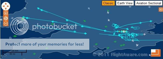
That UN14 air traffic when the conditions are right for contrails will produce videos and images such as the following. Note the person refers to them as 'Chemtrails'. No doubt the same type of images that you are taking?
www.checktheevidence.co.uk...
Contrary to what you believe aircraft at contrail producing heights also cross Upper Air Route UN14. For example some airliners flying out of Birmingham International are routed to a waypoint in your shire. For examle waypoint MOSUN coordinates 51 53 38N 02 26 10W
MOSUN coordintates at following.
www.ead.eurocontrol.int...
Map showing MOSUN waypoint.
ivao.co.uk...
Crossing such air routes is covered in the following.
CAP 493 Manual of Air Traffic Services Part 1
www.caa.co.uk...
An example of this is a Boeing 767 from Birmingham noted today crossing UN14 and using the waypoints within the shire on its way to the Dominican Republic.
flightaware.com...
In addition to civilian aircraft there are also military aircraft that cross upper air routes. The RAF Eurofighter Typhoon in particular can transit above the airliner traffic and routinely do so
in order to get to UK military training areas.
Flt Lt Tim Clement, an RAF Typhoon Pilot, reveals in interview.
From
www.globalaviationresource.com...
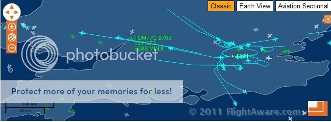
A snapshot of the traffic as seen in the Flight Aware screen capture using Upper Air Route UN14.
Flight AAL87
Boeing 777
flightaware.com...
Route using UN14 after taking off from London Heathrow bound for Chicago.
Flight AAL57
Boeing 777
flightaware.com...
Route using UN14 after taking off from London Heathrow bound for Miami.
Flight BAW207
Boeing 747
flightaware.com...
Route using UN14 after taking off from London Heathrow bound for Miami.
Flight VIR3
Airbus A340
flightaware.com...
Route using UN14 after taking off from London Heathrow bound for New York.
So in your vicinity there is a busy air route and waypoint. Aircraft can transit through the waypoint and above the Upper Air Route and not just in one direction. The Upper Air Routes can be 10nm wide with aircraft and trails crossing over each other. If the conditions favour persistent contrails then what you will see are grid and x-patterns as you can see in the video and still links posted.
I've just checked back and noted your video. It is classic chemtrail jibberish. Everything contained in it. The Sun, cloudseeding and now you can taste it?
Your video
You are the one originally stating that only the Heathrow-Dublin flight passes over you location. This is clearly not correct as Upper Air Route UN14 passes your location. A busy, busy air route that you can follow and track on Flight Aware. Sorry, epic fail on your video. You clearly have not been honest in your description or you have just been totally unaware of the busy, busy ATC route in your area. An air route that will generate 'X shapes' and 'grids' when conditions are favourable for contrails. It is no use just pointing your camera into the sky when you clearly have no understanding of the ATC zone in your region. Anyone can do it!
TJ
That post clearly shows that you don't understand the ATC zones that are in your area. What you are doing is just guessing the same way as you are guessing that the airliners are cloud seeding. You can track what you are seeing on Flight Aware. People do it for a hobby. Try it sometime instead of guessing what is in your region.
You live near Upper Air Route UN14. Contrary to what you reveal UN14 is a busy east-west/west-east. This covers regional and transatlantic flights and not just Heathrow-Dublin. How do you think flights route from Paris to Dublin? These routes are around 10 nautical miles wide. Think how many aircraft that you can fit into a corrider 10 nautical miles wide?
See following link for
UPPER AIRSPACE CONTROL AREA AND UPPER ATS (Air Traffic Services)ROUTES (South Sheet)
www.ead.eurocontrol.int...< br />
Note UN14.
The following is a Flight Aware screen capture from earlier today. You can see how busy UN14 is even on a Sunday with transatlantic traffic.
That UN14 air traffic when the conditions are right for contrails will produce videos and images such as the following. Note the person refers to them as 'Chemtrails'. No doubt the same type of images that you are taking?
www.checktheevidence.co.uk...
Contrary to what you believe aircraft at contrail producing heights also cross Upper Air Route UN14. For example some airliners flying out of Birmingham International are routed to a waypoint in your shire. For examle waypoint MOSUN coordinates 51 53 38N 02 26 10W
MOSUN coordintates at following.
www.ead.eurocontrol.int...
Map showing MOSUN waypoint.
ivao.co.uk...
Crossing such air routes is covered in the following.
CAP 493 Manual of Air Traffic Services Part 1
www.caa.co.uk...
An example of this is a Boeing 767 from Birmingham noted today crossing UN14 and using the waypoints within the shire on its way to the Dominican Republic.
flightaware.com...
In addition to civilian aircraft there are also military aircraft that cross upper air routes. The RAF Eurofighter Typhoon in particular can transit above the airliner traffic and routinely do so
in order to get to UK military training areas.
Flt Lt Tim Clement, an RAF Typhoon Pilot, reveals in interview.
"Equally, we usually transit across the UK at 40,000ft+, which means we are above all the airway traffic and can reach anywhere by taking a direct route, so this is both quick and efficient. The trick though is coming down from altitude as, if we select idle and point the aircraft five degrees nose down, we will still go supersonic. "We have to roll the aircraft inverted and pull back hard on the stick to unload all the energy and can then spiral downwards without breaking the sound barrier."
From
www.globalaviationresource.com...
A snapshot of the traffic as seen in the Flight Aware screen capture using Upper Air Route UN14.
Flight AAL87
Boeing 777
flightaware.com...
Route using UN14 after taking off from London Heathrow bound for Chicago.
Flight AAL57
Boeing 777
flightaware.com...
Route using UN14 after taking off from London Heathrow bound for Miami.
Flight BAW207
Boeing 747
flightaware.com...
Route using UN14 after taking off from London Heathrow bound for Miami.
Flight VIR3
Airbus A340
flightaware.com...
Route using UN14 after taking off from London Heathrow bound for New York.
So in your vicinity there is a busy air route and waypoint. Aircraft can transit through the waypoint and above the Upper Air Route and not just in one direction. The Upper Air Routes can be 10nm wide with aircraft and trails crossing over each other. If the conditions favour persistent contrails then what you will see are grid and x-patterns as you can see in the video and still links posted.
I've just checked back and noted your video. It is classic chemtrail jibberish. Everything contained in it. The Sun, cloudseeding and now you can taste it?
Your video
You are the one originally stating that only the Heathrow-Dublin flight passes over you location. This is clearly not correct as Upper Air Route UN14 passes your location. A busy, busy air route that you can follow and track on Flight Aware. Sorry, epic fail on your video. You clearly have not been honest in your description or you have just been totally unaware of the busy, busy ATC route in your area. An air route that will generate 'X shapes' and 'grids' when conditions are favourable for contrails. It is no use just pointing your camera into the sky when you clearly have no understanding of the ATC zone in your region. Anyone can do it!
TJ
reply to post by djcarlosa
I just saw this post....your description doesn't help me, much. I know you said "Welsh Coast", and some place where the water came inland...look, I'm worldly enough to know that "Welsh" means "Wales"....but, I need more specifics. I'm a map person.
IN the Euro ATS you see the "upper" Airways labelled with a 'U'...and then another letter. (Unlike the USA, where it is just a single 'J').
Now, I never bothered to go through the history of the evolution of the various letter adjuncts....(I will now, since I have more free time). BUT, We refer to them as...say, the routing labelled "UL149"? That would be called "Upper Lima one four nine(r)" (the "niner" is a bit old-fashioned, but technically the "correct" way...because, on the radio, "five" and "nine" can sound the same, in some cases).
'U' is normally "Uniform" in aviation phonetic alphabet terms....but, we still say "Upper"....just the common way it is. If a controller (or pilot) said "Uniform Lima", we would know exactly what he/she meant, too.....
Anyway....I would just like to know WHICH of those ATS routes you referred to. That way, I can take s look (also) at FlightRadar24 tracking....and a few others, as I find them.
I also want to add.....those tools, the "flight trackers", are the best easily available resources I can think of, to explain this nonsense of "chem"-trails, and show that the airplanes seen making contrails can be readily identified, one way or another. BUT, they are imperfect, unfortunately, in some ways....and it depends a lot on exactly how "real time" they really are. For instance, a major one I use here in the States has about an eight-minute delay....from the display, to the real-life position of the airplanes. Because, there are many sources that are gathered together, by the website that's hosting, before it can display the entire "picture". Keep that in mind, as you scan for the airplanes that are displayed, when trying to acquire t hem visually. Seven to eight miles per minute, remember....that's about normal speed, at cruise altitude. (420 - 480 knots, you see....).
reply to post by tommyjo
the point I'm making here is that last summer there where no planes flying in he directions you see in the vid I posted this is the change I have seen in the last 2 months i wish i could go back and take a vid of the sky last year around this time so you could see the difference there are no airports in the directions these planes are flying and to also point out that yes the Dublin route has alot of traffic and i see those planes going overhead and there contrails dissipate within 2-3 mins so why do these others last so long and create clouds so quickly ?
the point I'm making here is that last summer there where no planes flying in he directions you see in the vid I posted this is the change I have seen in the last 2 months i wish i could go back and take a vid of the sky last year around this time so you could see the difference there are no airports in the directions these planes are flying and to also point out that yes the Dublin route has alot of traffic and i see those planes going overhead and there contrails dissipate within 2-3 mins so why do these others last so long and create clouds so quickly ?
new topics
-
HORRIBLE !! Russian Soldier Drinking Own Urine To Survive In Battle
World War Three: 13 minutes ago -
Bobiverse
Fantasy & Science Fiction: 3 hours ago -
Florida man's trip overseas ends in shock over $143,000 T-Mobile phone bill
Social Issues and Civil Unrest: 3 hours ago -
Former Labour minister Frank Field dies aged 81
People: 5 hours ago -
SETI chief says US has no evidence for alien technology. 'And we never have'
Aliens and UFOs: 7 hours ago -
This is our Story
General Entertainment: 9 hours ago
top topics
-
President BIDEN Vows to Make Americans Pay More Federal Taxes in 2025 - Political Suicide.
2024 Elections: 12 hours ago, 14 flags -
One Flame Throwing Robot Dog for Christmas Please!
Weaponry: 16 hours ago, 6 flags -
SETI chief says US has no evidence for alien technology. 'And we never have'
Aliens and UFOs: 7 hours ago, 5 flags -
Florida man's trip overseas ends in shock over $143,000 T-Mobile phone bill
Social Issues and Civil Unrest: 3 hours ago, 5 flags -
Ditching physical money
History: 16 hours ago, 4 flags -
Don't take advantage of people just because it seems easy it will backfire
Rant: 16 hours ago, 4 flags -
Former Labour minister Frank Field dies aged 81
People: 5 hours ago, 4 flags -
Ode to Artemis
General Chit Chat: 12 hours ago, 3 flags -
Bobiverse
Fantasy & Science Fiction: 3 hours ago, 3 flags -
This is our Story
General Entertainment: 9 hours ago, 3 flags
active topics
-
HORRIBLE !! Russian Soldier Drinking Own Urine To Survive In Battle
World War Three • 3 • : Bluntone22 -
President BIDEN Vows to Make Americans Pay More Federal Taxes in 2025 - Political Suicide.
2024 Elections • 62 • : 5thHead -
-@TH3WH17ERABB17- -Q- ---TIME TO SHOW THE WORLD--- -Part- --44--
Dissecting Disinformation • 641 • : Thoughtful3 -
SETI chief says US has no evidence for alien technology. 'And we never have'
Aliens and UFOs • 28 • : Ophiuchus1 -
University student disciplined after saying veganism is wrong and gender fluidity is stupid
Education and Media • 46 • : YourFaceAgain -
Ditching physical money
History • 17 • : SprocketUK -
The Reality of the Laser
Military Projects • 39 • : Scratchpost -
Who are the Russians?
New World Order • 201 • : DISBOLD -
Geddy Lee in Conversation with Alex Lifeson - My Effin’ Life
People • 5 • : underpass61 -
Europe declares war on Russia?
World War Three • 68 • : DISBOLD