It looks like you're using an Ad Blocker.
Please white-list or disable AboveTopSecret.com in your ad-blocking tool.
Thank you.
Some features of ATS will be disabled while you continue to use an ad-blocker.

Overwhelming Evidence Pentagon Aircraft Data Is Not From An American Airlines 757
page: 16share:
Originally posted by backinblack
reply to post by roboe
Airplane becomes airborne, it starts recieving VOR data, it starts triangulating its position?
To 200' accuracy??
Even weedwhacker stated up to 2 miles deviation was acceptable...
What does 2 nm deviation being acceptable have to do with the accuracy? For all I know, that 2 nm deviation could be after flying for an extended period through area with little or no ground stations. There's plenty of VOR ground stations in and around Washington DC, so plenty of points available for triangulation.
reply to post by roboe
I've been to sites from both sides and no one seems to agree with that kind of accuracy..
Especially if the starting data is 3600' off and the plane was running INS with no GPS...
I've been to sites from both sides and no one seems to agree with that kind of accuracy..
Especially if the starting data is 3600' off and the plane was running INS with no GPS...
Originally posted by backinblack
Originally posted by Reheat
Originally posted by backinblack
Mate, you contradict yourself in that post and call me a fraud etc.??
I am now convinced that your reading comprehension problem is intention unless the English Language is not your native tongue. You definitely need remedial reading help.
Interesting..Here's a few posts from you on this very page...
Yes, that is exactly what I'm saying, it's made up. There is no such thing as auto-align in either Commercial or Military Aircraft.
And then....
How would you know? I didn't say they could not align in-flight.
Are you freaking blind? Since when are auto-align and align the same thing? You have repeatedly misquoted me because you simply apparently don't know the difference or you have a pronounced reading comprehension problem. If you don't know the difference why are you posting in a thread that is quite obviously over your head?
edit on 7-3-2011 by Reheat because: (no reason given)
reply to post by Reheat
What are you saying?
Do you think the pilot looks out the window, checks for points of reference, looks at his map and then puts in the new position.??
It's called "Auto Align" because the plane does it Automatically......
Are you freaking blind? Since when are auto-align and align the same thing?
What are you saying?
Do you think the pilot looks out the window, checks for points of reference, looks at his map and then puts in the new position.??
It's called "Auto Align" because the plane does it Automatically......
Originally posted by backinblack
reply to post by Reheat
Are you freaking blind? Since when are auto-align and align the same thing?
What are you saying?
Do you think the pilot looks out the window, checks for points of reference, looks at his map and then puts in the new position.??
It's called "Auto Align" because the plane does it Automatically......
I believe reheat has been referring to that as an "update".

Originally posted by backinblack
reply to post by roboe
I've been to sites from both sides and no one seems to agree with that kind of accuracy..
Especially if the starting data is 3600' off and the plane was running INS with no GPS...
Maximum 200 meters, that B757-200 didn't have GPS.
alright, this has become so complex, with so many variables that it's no longer relevant for an argument on the factors of AA 77. I'm amazed how
much I've learned about VOR and DME, and RMS and NAV, triple mix and GPS... but I still don't know how to read the actual NTSB data in order to ....
write my congressional representatives!
When I first read about this airborne auto-alignment, only available on military aircraft, I gotta say I was really excited! But it turns out there is no single, verifiable "value" on the NTSB data to show this, that it was deduced from the data that might or might not be precise (eg. the 3000+ feet off but possible quick align once on the runway). The GPS "OPER" is in the porton of the NTSB data designated as "Parameters Not Working or Unconfirmed".
So yet AGAIN in the enormous saga which is 9/11 truth, I am at a probable?, possible? situation that is not easily sellable or even known to be true... ugh.
I recommend Absolute Proof: A Pentagon picture montage by yours truly - because if there's NO HOLE, there was no plane!
I'm joking but have sorta given up on getting an absolute, precise answer to whether the NTSB data came from N644AA on 9/11. Best of luck y'all, see ya when I see ya.
Originally posted by BCRFiles
weedwhacker, would you have departed if you saw a 3,000+ foot lat/llong offset on your HSI map, as is shown in the FDR data?
Capt Ralph Kolstad along with other American Airlines pilots and pilots from pprune say no, they wouldn't. So, why did this aircraft depart with such a large error in lat/long?
For those genuinely interested in this discussion here is a recorded example of B00b Balsamo's deceit regarding this specific issue. Note the underlined passage above. Now, read this link and show me where anyone said that at pprune.
www.pprune.org...
Can anyone show me where that was said or even implied at pprune?
Even the question at pprune likely from Balsamo was deceptively worded. The initial question indicated the IRS was NOT ALIGNED. How ask yourself how he knows that. It was definitely inaccurate, but there are NO INDICATIONS it was not aligned. Perhaps one of the pilots input the Airfield coordinates as opposed to gate coordinates, perhaps there were no gate coordinates listed in the Jeppesen manual for IAD in 2001. I DO NOT KNOW and neither does B00by Balsamo.
The Navigation System in the aircraft showed gross errors on previous flight ON THE GROUND so the last flight was not particularly unique in that regard. It did update during flight as it's suppose to do indicating it was aligned on the ground, although inaccurate.
There are IMPLIED LIES and deceitful statements at pffft for most of their conclusion regarding anything related to 9/11. This issue is obviously no exception.
Two primary questions remain: Was the position error at IAD shown in the FDR data out of tolerance for flight and not acceptable? How has B00by Balsamo determined the IRS was not aligned as he has explicited stated several times?
edit on 8-3-2011 by Reheat because: (no reason
given)
edit on 8-3-2011 by Reheat because: (no reason given)
reply to post by backinblack
I am playing "catch up" here. So, piece by piece, I will attempt to clarify as much as possible (keeping in mind that, as I continually suspect, a certain Rob Balsamo is bound to come in occasionally, using a recently-minted sock-puppet screen name, so stay aware for the DIS-info that will no doubt spew, as a result....).
I did not read that exact exchange, so without the context....and without knowing what source of reference may have influenced reheat's comment, I cannot say whether or not that is the case with American 77.
Generally, with all of those systems, in that time (pre-GPS updating, I repeat again) the INUs were NEVER counted on for "accuracy".
Just by skimming through some recent posts (from someone I strongly suspect is Rob Balsamo, again) I see that WAY too much emphasis and importance is being given to the IRS. That is the reason I wrote in such detail.....to relate procedures, step-by-step in some cases.
In the "Terminal Area" (that is generally considered to be operations, usually, below about 10,000 feet, and within about 30 miles of the airport (exact guidelines are not defined, the specifics vary by airport and locality) ...when operating in the most densely-occupied and busiest airspace, where more precision is required, the IRS was NOT the preferred reference for navigation. It was considered appropriate for en-route navigation, where separation standards have much more margin.
On departure, the references are usually from ground-based VORs...OR, simply radar vectors...so the controller decides where to "send" and to "point" the airplane....but, the controller will assign a future "route", when giving a radar vector....and, it is always implied anyway, per the filed flight plan (this is for that very rare contingency of communications failure. Old habit and procedures, from days long past, but still in force).
During the last decade, though....IRS accuracy, "tightness" and with GPS precision....it is so much more accurate that many more RNAV procedures have been adopted, specifically and ONLY for airplanes equipped with GPS-up-datable Inertial Nav Units systems. But, to repeat...this was NOT commonplace in 2001.
Finally...as to the old, pre-GPS IRS "drift"...it was constantly correcting it (them)selves...and, to repeat for emphasis once more, the airplane referenced and displayed the "triple mix" average of all three units.
To keep an "eye" on the "health" of each individual unit, it was (still is) a requirement to log into the aircraft LogBook, end of every flight, the "IRS accuracy" readings.
(I would have thought that Rob Balsamo, and Ralph Kolstad, of all people, knew this......funny, they omit explaining in proper detail, isn't it???)
The units keep track of elapsed time they are in align mode, for each flight...and the average amount of MILES they calculated their accumulated errors to be. The hours of operation are divided into the average "drift", and those numbers are displayed on an info page, you access from the menu....and you write those figures into specific places, in the LogBook, designed to record the values.
EVERY airline pilot (except, apparently, Ralph Kolstad) know all of this, already....that is why the vast majority of us laugh at the clowns of "P4T". It is only when they get so incredibly pesky, and become such irritants, spewing their ever-ridiculous DIS-info, that something needs to be "said" (written) to be put into the "O.O.R." (Official Online Record).
Because, as everyone should realize by now, nothing put out onto the Web every goes away. SO, FACTS must be sent out into the ether, in order to straighten out reality, and counter-act the crap.....
I am playing "catch up" here. So, piece by piece, I will attempt to clarify as much as possible (keeping in mind that, as I continually suspect, a certain Rob Balsamo is bound to come in occasionally, using a recently-minted sock-puppet screen name, so stay aware for the DIS-info that will no doubt spew, as a result....).
Originally posted by backinblack
This one I asked earlier..
Another poster "reheat" says the INS corrected itself by the end of the flight to an accuracy of 200'..
Can you tell me how it did that ???
I did not read that exact exchange, so without the context....and without knowing what source of reference may have influenced reheat's comment, I cannot say whether or not that is the case with American 77.
Generally, with all of those systems, in that time (pre-GPS updating, I repeat again) the INUs were NEVER counted on for "accuracy".
Just by skimming through some recent posts (from someone I strongly suspect is Rob Balsamo, again) I see that WAY too much emphasis and importance is being given to the IRS. That is the reason I wrote in such detail.....to relate procedures, step-by-step in some cases.
In the "Terminal Area" (that is generally considered to be operations, usually, below about 10,000 feet, and within about 30 miles of the airport (exact guidelines are not defined, the specifics vary by airport and locality) ...when operating in the most densely-occupied and busiest airspace, where more precision is required, the IRS was NOT the preferred reference for navigation. It was considered appropriate for en-route navigation, where separation standards have much more margin.
On departure, the references are usually from ground-based VORs...OR, simply radar vectors...so the controller decides where to "send" and to "point" the airplane....but, the controller will assign a future "route", when giving a radar vector....and, it is always implied anyway, per the filed flight plan (this is for that very rare contingency of communications failure. Old habit and procedures, from days long past, but still in force).
During the last decade, though....IRS accuracy, "tightness" and with GPS precision....it is so much more accurate that many more RNAV procedures have been adopted, specifically and ONLY for airplanes equipped with GPS-up-datable Inertial Nav Units systems. But, to repeat...this was NOT commonplace in 2001.
Finally...as to the old, pre-GPS IRS "drift"...it was constantly correcting it (them)selves...and, to repeat for emphasis once more, the airplane referenced and displayed the "triple mix" average of all three units.
To keep an "eye" on the "health" of each individual unit, it was (still is) a requirement to log into the aircraft LogBook, end of every flight, the "IRS accuracy" readings.
(I would have thought that Rob Balsamo, and Ralph Kolstad, of all people, knew this......funny, they omit explaining in proper detail, isn't it???)
The units keep track of elapsed time they are in align mode, for each flight...and the average amount of MILES they calculated their accumulated errors to be. The hours of operation are divided into the average "drift", and those numbers are displayed on an info page, you access from the menu....and you write those figures into specific places, in the LogBook, designed to record the values.
EVERY airline pilot (except, apparently, Ralph Kolstad) know all of this, already....that is why the vast majority of us laugh at the clowns of "P4T". It is only when they get so incredibly pesky, and become such irritants, spewing their ever-ridiculous DIS-info, that something needs to be "said" (written) to be put into the "O.O.R." (Official Online Record).
Because, as everyone should realize by now, nothing put out onto the Web every goes away. SO, FACTS must be sent out into the ether, in order to straighten out reality, and counter-act the crap.....
Originally posted by Reheat
B00b Balsamo's...
B00by Balsamo.
I would just like to point out that, in my opinion, your name-calling has no affect on what Mr. Balsamo said, it just makes you come across as an immature person who resorts to name calling.
Originally posted by weedwhacker
Generally, with all of those systems, in that time (pre-GPS updating, I repeat again) the INUs were NEVER counted on for "accuracy".
In the "Terminal Area" (that is generally considered to be operations, usually, below about 10,000 feet, and within about 30 miles of the airport (exact guidelines are not defined, the specifics vary by airport and locality) ...when operating in the most densely-occupied and busiest airspace, where more precision is required, the IRS was NOT the preferred reference for navigation. It was considered appropriate for en-route navigation, where separation standards have much more margin.
On departure, the references are usually from ground-based VORs...OR, simply radar vectors...so the controller decides where to "send" and to "point" the airplane....but, the controller will assign a future "route", when giving a radar vector....and, it is always implied anyway, per the filed flight plan (this is for that very rare contingency of communications failure. Old habit and procedures, from days long past, but still in force).
During the last decade, though....IRS accuracy, "tightness" and with GPS precision....it is so much more accurate that many more RNAV procedures have been adopted, specifically and ONLY for airplanes equipped with GPS-up-datable Inertial Nav Units systems. But, to repeat...this was NOT commonplace in 2001.
Finally...as to the old, pre-GPS IRS "drift"...it was constantly correcting it (them)selves...and, to repeat for emphasis once more, the airplane referenced and displayed the "triple mix" average of all three units.
To keep an "eye" on the "health" of each individual unit, it was (still is) a requirement to log into the aircraft LogBook, end of every flight, the "IRS accuracy" readings.
(I would have thought that Rob Balsamo, and Ralph Kolstad, of all people, knew this......funny, they omit explaining in proper detail, isn't it???)
The units keep track of elapsed time they are in align mode, for each flight...and the average amount of MILES they calculated their accumulated errors to be. The hours of operation are divided into the average "drift", and those numbers are displayed on an info page, you access from the menu....and you write those figures into specific places, in the LogBook, designed to record the values.
EVERY airline pilot (except, apparently, Ralph Kolstad) know all of this, already....that is why the vast majority of us laugh at the clowns of "P4T". It is only when they get so incredibly pesky, and become such irritants, spewing their ever-ridiculous DIS-info, that something needs to be "said" (written) to be put into the "O.O.R." (Official Online Record).
Because, as everyone should realize by now, nothing put out onto the Web every goes away. SO, FACTS must be sent out into the ether, in order to straighten out reality, and counter-act the crap.....
Weed I feel you're pulling some tricks on this post...why even mention INU. Anyone who knows what an INU is knows you're just trying to put a discreding statement and connotation without actually saying anything.
Then you actually kill your own argument saying every pilot knows you need to check the books after each flight! If the ground error carried on from flight 11 to flight 12 (IAD -> Pentagon allegedly) then it would have been MORE likely to never have taken off with that huge error. I think you actually just helped the truthers in a big way.
Mods - sorry about the large re-quote but it's all pertinent to my statement; I took out what I could.
edit on 8-3-2011 by Thermo Klein because: (no reason given)
Originally posted by Thermo Klein
Originally posted by Reheat
B00b Balsamo's...
B00by Balsamo.
I would just like to point out that, in my opinion, your name-calling has no affect on what Mr. Balsamo said, it just makes you come across as an immature person who resorts to name calling.
Well, thanks for your opinion. I don't consider someone who makes every attempt to mislead and deceive people a very respectable person deserving of the title of Mr either. Do you know of anyone else in existence who has been repeatedly banned from virtually every 9/11 Forum on the Internet for cause? Yes, he is such a respectable person, that's why ATS will ban him with just a very few posts even with one of his multiple socks......repeatedly.
Yes, he and everyone else who accuse respectable people of mass murder with no credible evidence deserve much worse name calling. If I called him what he rightfully deserves I wouldn't last long here or anywhere else.
(Had to edit in to format the "Reply-To"):
reply to post by BCRFiles
Great. I needed a thorough explanation and description in order to address it properly.
I decided to respond "for the record" to this post, despite the member's banning. The decision came about as I postulate a guess, ladies and gentlemen of the audience, that if we researched a bit, we might discover that Rob Balsamo of "Pilots" for "Truth" very likely has a middle name that begins with the letter 'C'...just a supposition on my part. Hence, my being intrigued by this (another new) 'username'. Three capitals, as in a person's name monogram (but in reverse), followed by the word "Files". Seemed rather obvious, to me. (Sarah Palin made that fake face-book account....she wasn't too creative, either.....). Oh, well......>sigh< ^^
Carrying on:
Interesting. As I write this, I have not yet read that blog discussion, at JREF. But, I will.....
Well....IF you'd been reading the posts (I don't think "playing dumb" is an attrative trait to adopt) then it is obvious how the systems work and how they "update", by refining the calculate position...from ground-based Nav Aids.
Of course. The INUs had to be aligned, or else the primary flight instruments would not be erect and operable. The only other "choice" would be the "ATT" position of the IRU selectors. I presume the American Airlines MEL (minimum equipment list) would have provision for dispatch in that mode....there certainly is nothing unsafe about operating a flight with no Inertial References at all.....heck, that's just going back to the "old school" ways of doing things, after all. VOR navigation. The Airway System is designed, based on VORs from decades ago.....
Properly documented in the LogBook, placarded on the appropriate panels, the filed Flight Plan with FAA ATC, and the airplane equipment suffix amended to reflect non-RNAV capability...etc, etc. Paperwork, procedural to keep things legal. However, in the case of American 77, we know this not to be the circumstance for that flight.
Yes.....IF one of the pilots chose to select the MAP mode, and saw it was off a bit...well, then it is a judgement call. AND, the "biggles" source, while is handy for these discussions, since it is easily used for illustrations, and quotes and such....it DOES represent the policy of a particular airline (Monarch, in the UK).
We don't know the mode selector positions that each pilot had selected, prior to takeoff....nor what they changed, and when in flight....BUT this can be determined from the FDR info. Mode selections, time selected and which side (L / R) are recorded. BUT, for that flight, and the weather conditions that day (severe clear) AND, the fact that the departure procedure was not RNAV-specific, nor dependent....well, they (as just about all of us) knew that the FMC position ("triple mix") would update either through the TOGA function (if it was an installed feature) or later, once airborne, with the normal radio updating functions.
THIS IS WHY THE BOGUS CLAIMS OF "PilotsFor Truth" ARE SO RIDICULOUS....and over stated....and extravagant, and just nonsense. It is apparent that "they" are merely desperate to make something out of nothing...while counting on the general ignorance and lack of technical expertise of the regular public, to keep the deception alive......
....which makes this next "question" (and I can clearly see that it is really meant to be a rhetorical dangling inference) rather irrelevant:
See above.
Huh? We have Kolstad, who put on such an embarrassing display for Jesse Ventura's TV show, making such claims? What, is he anal retentive or something? A pain in the butt to fly with, when he was still an active line pilot? Because, anyone who, on a day like that, in that kind of weather, would "worry or fret" over a minor map shift like that?? (BTW. 'map shift' is the proper term we use...you've pried it out of me.....I was waiting for one of the "P4T" clowns to mention it first, but alas....NOW you are even 'better' informed than before!! >sigh
reply to post by BCRFiles
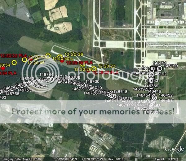
The picture weedwhacker is referring to is this picture.
Source - www.abovetopsecret.com...
White is the lat/long according to PRES POS LAT/LONG (DEG) from the FDR file, Yellow and Red are radar returns. You can see them merge in flight.

Great. I needed a thorough explanation and description in order to address it properly.
I decided to respond "for the record" to this post, despite the member's banning. The decision came about as I postulate a guess, ladies and gentlemen of the audience, that if we researched a bit, we might discover that Rob Balsamo of "Pilots" for "Truth" very likely has a middle name that begins with the letter 'C'...just a supposition on my part. Hence, my being intrigued by this (another new) 'username'. Three capitals, as in a person's name monogram (but in reverse), followed by the word "Files". Seemed rather obvious, to me. (Sarah Palin made that fake face-book account....she wasn't too creative, either.....). Oh, well......>sigh< ^^
Carrying on:
The original source is John Farmer. Farmer claims he plotted the above course based on Lat/Long Coordinates from the FDR file.
Source - forums.randi.org...
Interesting. As I write this, I have not yet read that blog discussion, at JREF. But, I will.....
The 3,000+ foot offset shown at IAD appears to merge in flight after departure according to John Farmer and the FDR Data.
How is this possible if the FDR data shows more than a 3,000+ foot offset before departure?
Well....IF you'd been reading the posts (I don't think "playing dumb" is an attrative trait to adopt) then it is obvious how the systems work and how they "update", by refining the calculate position...from ground-based Nav Aids.
According to the links provided by Reheat and others, including the explanation given by weedwhacker, the Lat/Long positions are aligned on the ground prior to takeoff.
Of course. The INUs had to be aligned, or else the primary flight instruments would not be erect and operable. The only other "choice" would be the "ATT" position of the IRU selectors. I presume the American Airlines MEL (minimum equipment list) would have provision for dispatch in that mode....there certainly is nothing unsafe about operating a flight with no Inertial References at all.....heck, that's just going back to the "old school" ways of doing things, after all. VOR navigation. The Airway System is designed, based on VORs from decades ago.....
Properly documented in the LogBook, placarded on the appropriate panels, the filed Flight Plan with FAA ATC, and the airplane equipment suffix amended to reflect non-RNAV capability...etc, etc. Paperwork, procedural to keep things legal. However, in the case of American 77, we know this not to be the circumstance for that flight.
On the ground, the FMC position is based on the IRS position.
Since inertial systems accumulate position errors as a function of time, the position information being used by the FMC is slowly accumulating errors. These position errors can be detected by observing the position of the airplane on the HSI map. If an extended ground delay occurs and a significant map error is noticed the IRS should be realigned and present position re-entered.
Source - www.biggles-software.com...
Yes.....IF one of the pilots chose to select the MAP mode, and saw it was off a bit...well, then it is a judgement call. AND, the "biggles" source, while is handy for these discussions, since it is easily used for illustrations, and quotes and such....it DOES represent the policy of a particular airline (Monarch, in the UK).
We don't know the mode selector positions that each pilot had selected, prior to takeoff....nor what they changed, and when in flight....BUT this can be determined from the FDR info. Mode selections, time selected and which side (L / R) are recorded. BUT, for that flight, and the weather conditions that day (severe clear) AND, the fact that the departure procedure was not RNAV-specific, nor dependent....well, they (as just about all of us) knew that the FMC position ("triple mix") would update either through the TOGA function (if it was an installed feature) or later, once airborne, with the normal radio updating functions.
THIS IS WHY THE BOGUS CLAIMS OF "PilotsFor Truth" ARE SO RIDICULOUS....and over stated....and extravagant, and just nonsense. It is apparent that "they" are merely desperate to make something out of nothing...while counting on the general ignorance and lack of technical expertise of the regular public, to keep the deception alive......
....which makes this next "question" (and I can clearly see that it is really meant to be a rhetorical dangling inference) rather irrelevant:
weedwhacker, would you have departed if you saw a 3,000+ foot lat/llong offset on your HSI map, as is shown in the FDR data?
See above.
Capt Ralph Kolstad along with other American Airlines pilots and pilots from pprune say no, they wouldn't. So, why did this aircraft depart with such a large error in lat/long?
Huh? We have Kolstad, who put on such an embarrassing display for Jesse Ventura's TV show, making such claims? What, is he anal retentive or something? A pain in the butt to fly with, when he was still an active line pilot? Because, anyone who, on a day like that, in that kind of weather, would "worry or fret" over a minor map shift like that?? (BTW. 'map shift' is the proper term we use...you've pried it out of me.....I was waiting for one of the "P4T" clowns to mention it first, but alas....NOW you are even 'better' informed than before!! >sigh
reply to post by weedwhacker
Weedwhacker, this is the best and most comprehensive post I've ever seen from you at ATS or anywhere else. Absolutely accurate summation of the FACTS. Well done, Sir!
This post should end this stupid and ridiculous thread, but I'd venture a guess that it won't. There are just too many experts here.
Weedwhacker, this is the best and most comprehensive post I've ever seen from you at ATS or anywhere else. Absolutely accurate summation of the FACTS. Well done, Sir!
This post should end this stupid and ridiculous thread, but I'd venture a guess that it won't. There are just too many experts here.
edit on 8-3-2011 by Reheat because: (no reason given)
reply to post by Thermo Klein
Allow me to clear up some of your misconceptions:
Nope. The only "tricks" come from the fertile, creative, spilt 'essential bodily fluids' flowing from the "Pilots" for "Truth"....
sigh. Terminology can be tricky, and precision distorted....and you can become inured to the same terms, over and over again, when used repeatedly. The "INU" is an inertial nav unit. The "IRS" is the inertial reference SYSTEM. The INUs are but a component of the entire system...I tried to reference them, in particular, depending what I was talking about. Reason being, each INU (they are little "systems" of their own, too...if you think about it....laser-ring gyros, circuit boards, etc) is independent. I thought I made that emphatically clear. Their inputs are processed by the IRS and used by the FMC (and displayed to the crew).
It only seems complex at the first pass....they are complicated machines, but once you get a grasp of how all components interface, it becomes clear. (Think of a person who had never seen the inside of, nor knew anything at all about, your computer. Open up your desktop Tower case, and then explain how all those parts work in concert together.....).
I am hurt. I think I cried just a bit....a muffled sob.......
NO, again misunderstanding the POINT of logging the IRS performance error trends. That is looked at by Maintenance, on whatever schedule they use, to see if there are signs of an INU about to "go south".
The figures are there, too, for the next flight crew to see....frankly, unless you are about to go on an extended over-water flight, you really DON'T CARE all that much!
Also.....there are parameters of tolerance, in those accumulate figures....these are in the Aircraft Flight Manual. The errors have to be quite large, in order to draw attention or concern...anything over about 4.0 NM per hour, and you then make a write-up in the LogBook....a write-up (used to be called a "squawk", before the advent of radar and transponders....some still use that archaic term to apply here) requires MX action. ANY entry onto a log page, that is "complaining" or pointing out an operational issue, a failed component, etc, must be "signed off" by the qualified mechanic. This is also (nowadays, of course) all put into computer databases kept in-house at every airline. (I often felt some pity for the poor people whose job it is to have to actually read those pages.....there are SO many of them, every day, it's staggering. AND, some of the handwriting!!! Makes doctors look like calligraphers!!).
Allow me to clear up some of your misconceptions:
Weed I feel you're pulling some tricks on this post...
Nope. The only "tricks" come from the fertile, creative, spilt 'essential bodily fluids' flowing from the "Pilots" for "Truth"....
....why even mention INU.
sigh. Terminology can be tricky, and precision distorted....and you can become inured to the same terms, over and over again, when used repeatedly. The "INU" is an inertial nav unit. The "IRS" is the inertial reference SYSTEM. The INUs are but a component of the entire system...I tried to reference them, in particular, depending what I was talking about. Reason being, each INU (they are little "systems" of their own, too...if you think about it....laser-ring gyros, circuit boards, etc) is independent. I thought I made that emphatically clear. Their inputs are processed by the IRS and used by the FMC (and displayed to the crew).
It only seems complex at the first pass....they are complicated machines, but once you get a grasp of how all components interface, it becomes clear. (Think of a person who had never seen the inside of, nor knew anything at all about, your computer. Open up your desktop Tower case, and then explain how all those parts work in concert together.....).
Anyone who knows what an INU is knows you're just trying to put a discreding statement and connotation without actually saying anything.
I am hurt. I think I cried just a bit....a muffled sob.......
Then you actually kill your own argument saying every pilot knows you need to check the books after each flight! If the ground error carried on from flight 11 to flight 12 (IAD -> Pentagon allegedly) then it would have been MORE likely to never have taken off with that huge error. I think you actually just helped the truthers in a big way.
NO, again misunderstanding the POINT of logging the IRS performance error trends. That is looked at by Maintenance, on whatever schedule they use, to see if there are signs of an INU about to "go south".
The figures are there, too, for the next flight crew to see....frankly, unless you are about to go on an extended over-water flight, you really DON'T CARE all that much!
Also.....there are parameters of tolerance, in those accumulate figures....these are in the Aircraft Flight Manual. The errors have to be quite large, in order to draw attention or concern...anything over about 4.0 NM per hour, and you then make a write-up in the LogBook....a write-up (used to be called a "squawk", before the advent of radar and transponders....some still use that archaic term to apply here) requires MX action. ANY entry onto a log page, that is "complaining" or pointing out an operational issue, a failed component, etc, must be "signed off" by the qualified mechanic. This is also (nowadays, of course) all put into computer databases kept in-house at every airline. (I often felt some pity for the poor people whose job it is to have to actually read those pages.....there are SO many of them, every day, it's staggering. AND, some of the handwriting!!! Makes doctors look like calligraphers!!).
edit on 8 March 2011 by weedwhacker because: (no reason given)
reply to post by weedwhacker
I'm zeroing in on my post, above, with this addendum:
That was a grand assumption, based on my experience....although, I did not operate in nor out of KIAD very often. SO, I can't recall for certain IF, in September, 2001, any RNAV-specific departures had yet been published for that airport. In late 2001, there were very, very few of that nature, in the USA.
Looking at the info for today, the airport still has the "normal" departure procedure that has likely been in use from the first day. Situated as it is, in about the middle of nowhere, there isn't a lot of restriction on departure routes, and no need for overly-complicate procedures, as seen at many other airports (the New York area, for example).
This one, the "CAPITAL SEVEN" departure (that number is changed each time there is a significant alteration to the procedure. For instance, when first published, it would have been called "Capital One". Over time, things are added / deleted / changed, etc....and if it impacts the specifics (and not just, say, a departure control frequency change) then they change the name. Sometimes, a completely new procedure may be adopted, in which case will delete the "old" one, and have an entirely different name.
The "Cap 7" is a radar-vector procedure. That, as I said, is common at airports like Dulles (and Denver, etc) where they have so much open area around them, and few or no significant obstructions.
The plain-language "verbiage":
The printed pages: flightaware.com...
The only other (currently) Departure from KIAD IS an RNAV procedure. They are actually quite common, today:
The "STOIC TWO"
And,
All Departures for KIAD
Now....the more astute readers may note something important about the "STOIC 2"......see it yet??
That's right...the directions of departure it is intended for. East, Northeast and South. SO, even if this RNAV procedure was in effect in 2001, it never would have been assigned to American Airlines flight 77, due to that flight's route to the West, and Los Angeles.....
(In case anyone wonders about the way they "name" these things.....the 'Capital' name is just sort of generic, since it's a non-specific procedure. it isn't "anchored" by any navigational fixes. The "STOIC", and others of this sort, are named for the "anchor" fix....all five-letter fixes are way-points....they may, or may not also be intersections. The convention is five-letters for such fixes...to differentiate from VORs, which have three and airports, four).
I'm zeroing in on my post, above, with this addendum:
Originally posted by weedwhacker
AND, the fact that the departure procedure was not RNAV-specific, nor dependent....
That was a grand assumption, based on my experience....although, I did not operate in nor out of KIAD very often. SO, I can't recall for certain IF, in September, 2001, any RNAV-specific departures had yet been published for that airport. In late 2001, there were very, very few of that nature, in the USA.
Looking at the info for today, the airport still has the "normal" departure procedure that has likely been in use from the first day. Situated as it is, in about the middle of nowhere, there isn't a lot of restriction on departure routes, and no need for overly-complicate procedures, as seen at many other airports (the New York area, for example).
This one, the "CAPITAL SEVEN" departure (that number is changed each time there is a significant alteration to the procedure. For instance, when first published, it would have been called "Capital One". Over time, things are added / deleted / changed, etc....and if it impacts the specifics (and not just, say, a departure control frequency change) then they change the name. Sometimes, a completely new procedure may be adopted, in which case will delete the "old" one, and have an entirely different name.
The "Cap 7" is a radar-vector procedure. That, as I said, is common at airports like Dulles (and Denver, etc) where they have so much open area around them, and few or no significant obstructions.
The plain-language "verbiage":
CAPITAL SEVEN DEPARTURE
TAKE-OFF RUNWAYS 1C, 1L, 1R: Climb heading 011° or as assigned, Thence. . .
TAKE-OFF RUNWAY 12: Climb heading 121° or as assigned, Thence. . .
TAKE-OFF RUNWAYS 19C, 19L, 19R: Climb heading 191° or as assigned, Thence. . .
TAKE-OFF RUNWAY 30: Climb heading 301° or as assigned, Thence. . .
. . Expect radar vectors to filed/assigned route or depicted fix. Maintain 3000,
expect clearance to filed altitude/flight level 10 minutes after departure.
The printed pages: flightaware.com...
The only other (currently) Departure from KIAD IS an RNAV procedure. They are actually quite common, today:
The "STOIC TWO"
And,
All Departures for KIAD
Now....the more astute readers may note something important about the "STOIC 2"......see it yet??
That's right...the directions of departure it is intended for. East, Northeast and South. SO, even if this RNAV procedure was in effect in 2001, it never would have been assigned to American Airlines flight 77, due to that flight's route to the West, and Los Angeles.....
(In case anyone wonders about the way they "name" these things.....the 'Capital' name is just sort of generic, since it's a non-specific procedure. it isn't "anchored" by any navigational fixes. The "STOIC", and others of this sort, are named for the "anchor" fix....all five-letter fixes are way-points....they may, or may not also be intersections. The convention is five-letters for such fixes...to differentiate from VORs, which have three and airports, four).
edit on 8 March 2011 by weedwhacker because: (no reason given)
Originally posted by weedwhacker
Capt Ralph Kolstad along with other American Airlines pilots and pilots from pprune say no, they wouldn't. So, why did this aircraft depart with such a large error in lat/long?
Huh? We have Kolstad, who put on such an embarrassing display for Jesse Ventura's TV show, making such claims? What, is he anal retentive or something? A pain in the butt to fly with, when he was still an active line pilot? Because, anyone who, on a day like that, in that kind of weather, would "worry or fret" over a minor map shift like that?? (BTW. 'map shift' is the proper term we use...you've pried it out of me.....I was waiting for one of the "P4T" clowns to mention it first, but alas....NOW you are even 'better' informed than before!! >sigh
reply to post by rjh01a
Oh, for chrissakes!!! I love this!! Man, how petty can some people get? Surely, a dead giveaway as to this identity....RB, right?:
"Ten dash-nine" is the rather generic term. AND YOU KNOW THIS FULL WELL!!!!
Folks....the way the Jeppesen company number their charts is proprietary to just them. The government-issued charts (those are the ones freely available, when you go to places like "flightaware", or "airnav", are of course, NOT using this same system.
The case here, with the Washington area, is this: TWO airports are there, and EACH as the word "Washington" in the name! Jeppesen assigns the numeric digit " 1 " to denote the PRIMARY airport in those instances. "Primary" due to seniority, is usually the criteria.
"Washington National" Airport pre-dates "Washington Dulles" International Airport by many decades! (For those fans of such things, drop into KDCA and take the time to visit the 'Historic Terminal'. There are a series of 18-some aerial photos on display along the back wall, dating back to about 1930, up to present-day, showing the historical progress of the airport).
Even after the (appalling, to me) name-change at National, to "honor" the dead President Reagan.....its official name STILL has "Washington" in it. It is "Ronald Reagan Washington National" Airport --- now, "officially". Quite a mouthful. (BTW...I know of NOT ONE air traffic controller that EVER says "reagan"! Remember, he's the guy that fired them, in 1981...).
SO, being first, KDCA gets the numeral " 1 " assigned....this carries through on ALL the pages, as a prefix to the Jeppesen-specific numbering system.
KIAD gets the " 2 ", in a similar manner. From there, if anyone cares (and I doubt you will find this online, by searching...never tried it, so unsure...hey, knock yourselves out!!) the next numeral, " 0 " is for information, and other procedural pages. The dash, and the last number (and letter, if needed) is specific to the information presented. The dashes are assigned to various categories, some are just "placeholders", and have been pressed into use for the ever-increasing information overload nature of aviation....
The second numeral, as a " 1 ", denotes a precision instrument approach procedure. (ILS) Or, an non-precision that uses the localizer portion of the full ILS signal. The dash numbers are simply assigned to successive procedures, and usually according to runway number, starting with lowest. A second " 2 " is for a "PAR" approach....rare. The " 3 " for other non-precision approaches, like a VOR or (in the past) NDB. NDB approaches are just about extinct, nowadays in the United States....GPS used instead. (It is a big planet, however....). And so on.....
(I was going to point out that we could also look for gate Lat/Long info on the Jeppesen 10-7 ...excuse me, since it's KIAD, it would be the 20-7 page.....but, I figured that would just confuse Balsamo. Since, the "Dash-seven" pages are tailored specifically to those airlines that contract with Jeppesen to print and distribute them...for that airline's pilots to use. They have Company-specific info on them...and often include the gate coordinates.
(Although, for liability and cost reasons, not so much any more....airlines and Jepps feared that without as constant revisions as the "Dash-nine" pages, then the Lat/Long info could get old, but be used in lieu of the more current ones....minor point, bu t in today's litigious society......)
"Nice try", Rob....too bad you are always so, so wrong....
Oh, for chrissakes!!! I love this!! Man, how petty can some people get? Surely, a dead giveaway as to this identity....RB, right?:
weedy asked for a "10-9/9A" chart for Gate Coordinates so he can cross-check the IAD data. I initially corrected him that it's actually "20-9C" which contain the Lat/Long Coordinates for IAD Gates. (and most real pilots know this).
"Ten dash-nine" is the rather generic term. AND YOU KNOW THIS FULL WELL!!!!
Folks....the way the Jeppesen company number their charts is proprietary to just them. The government-issued charts (those are the ones freely available, when you go to places like "flightaware", or "airnav", are of course, NOT using this same system.
The case here, with the Washington area, is this: TWO airports are there, and EACH as the word "Washington" in the name! Jeppesen assigns the numeric digit " 1 " to denote the PRIMARY airport in those instances. "Primary" due to seniority, is usually the criteria.
"Washington National" Airport pre-dates "Washington Dulles" International Airport by many decades! (For those fans of such things, drop into KDCA and take the time to visit the 'Historic Terminal'. There are a series of 18-some aerial photos on display along the back wall, dating back to about 1930, up to present-day, showing the historical progress of the airport).
Even after the (appalling, to me) name-change at National, to "honor" the dead President Reagan.....its official name STILL has "Washington" in it. It is "Ronald Reagan Washington National" Airport --- now, "officially". Quite a mouthful. (BTW...I know of NOT ONE air traffic controller that EVER says "reagan"! Remember, he's the guy that fired them, in 1981...).
SO, being first, KDCA gets the numeral " 1 " assigned....this carries through on ALL the pages, as a prefix to the Jeppesen-specific numbering system.
KIAD gets the " 2 ", in a similar manner. From there, if anyone cares (and I doubt you will find this online, by searching...never tried it, so unsure...hey, knock yourselves out!!) the next numeral, " 0 " is for information, and other procedural pages. The dash, and the last number (and letter, if needed) is specific to the information presented. The dashes are assigned to various categories, some are just "placeholders", and have been pressed into use for the ever-increasing information overload nature of aviation....
The second numeral, as a " 1 ", denotes a precision instrument approach procedure. (ILS) Or, an non-precision that uses the localizer portion of the full ILS signal. The dash numbers are simply assigned to successive procedures, and usually according to runway number, starting with lowest. A second " 2 " is for a "PAR" approach....rare. The " 3 " for other non-precision approaches, like a VOR or (in the past) NDB. NDB approaches are just about extinct, nowadays in the United States....GPS used instead. (It is a big planet, however....). And so on.....
(I was going to point out that we could also look for gate Lat/Long info on the Jeppesen 10-7 ...excuse me, since it's KIAD, it would be the 20-7 page.....but, I figured that would just confuse Balsamo. Since, the "Dash-seven" pages are tailored specifically to those airlines that contract with Jeppesen to print and distribute them...for that airline's pilots to use. They have Company-specific info on them...and often include the gate coordinates.
(Although, for liability and cost reasons, not so much any more....airlines and Jepps feared that without as constant revisions as the "Dash-nine" pages, then the Lat/Long info could get old, but be used in lieu of the more current ones....minor point, bu t in today's litigious society......)
"Nice try", Rob....too bad you are always so, so wrong....
new topics
-
George Knapp AMA on DI
Area 51 and other Facilities: 5 hours ago -
Not Aliens but a Nazi Occult Inspired and then Science Rendered Design.
Aliens and UFOs: 5 hours ago -
Louisiana Lawmakers Seek to Limit Public Access to Government Records
Political Issues: 7 hours ago -
The Tories may be wiped out after the Election - Serves them Right
Regional Politics: 8 hours ago -
So I saw about 30 UFOs in formation last night.
Aliens and UFOs: 10 hours ago -
Do we live in a simulation similar to The Matrix 1999?
ATS Skunk Works: 11 hours ago
top topics
-
BREAKING: O’Keefe Media Uncovers who is really running the White House
US Political Madness: 12 hours ago, 24 flags -
George Knapp AMA on DI
Area 51 and other Facilities: 5 hours ago, 19 flags -
Biden--My Uncle Was Eaten By Cannibals
US Political Madness: 13 hours ago, 18 flags -
Louisiana Lawmakers Seek to Limit Public Access to Government Records
Political Issues: 7 hours ago, 7 flags -
"We're All Hamas" Heard at Columbia University Protests
Social Issues and Civil Unrest: 13 hours ago, 7 flags -
Russian intelligence officer: explosions at defense factories in the USA and Wales may be sabotage
Weaponry: 17 hours ago, 6 flags -
So I saw about 30 UFOs in formation last night.
Aliens and UFOs: 10 hours ago, 5 flags -
The Tories may be wiped out after the Election - Serves them Right
Regional Politics: 8 hours ago, 3 flags -
Not Aliens but a Nazi Occult Inspired and then Science Rendered Design.
Aliens and UFOs: 5 hours ago, 3 flags -
Do we live in a simulation similar to The Matrix 1999?
ATS Skunk Works: 11 hours ago, 3 flags
active topics
-
-@TH3WH17ERABB17- -Q- ---TIME TO SHOW THE WORLD--- -Part- --44--
Dissecting Disinformation • 534 • : cherokeetroy -
The US Supreme Court Appears to Side With the January 6th 2021 Capitol Protestors.
Political Conspiracies • 48 • : hoobah -
BREAKING: O’Keefe Media Uncovers who is really running the White House
US Political Madness • 11 • : BingoMcGoof -
Elites disapearing
Political Conspiracies • 28 • : hoobah -
African "Newcomers" Tell NYC They Don't Like the Free Food or Shelter They've Been Given
Social Issues and Civil Unrest • 14 • : GENERAL EYES -
God is watching.
Politicians & People • 28 • : glend -
George Knapp AMA on DI
Area 51 and other Facilities • 19 • : Brotherman -
It has begun... Iran begins attack on Israel, launches tons of drones towards the country
World War Three • 881 • : cherokeetroy -
Candidate TRUMP Now Has Crazy Judge JUAN MERCHAN After Him - The Stormy Daniels Hush-Money Case.
Political Conspiracies • 384 • : WeMustCare -
Election Year 2024 - Interesting Election-Related Tidbits as They Happen.
2024 Elections • 64 • : Zanti Misfit