It looks like you're using an Ad Blocker.
Please white-list or disable AboveTopSecret.com in your ad-blocking tool.
Thank you.
Some features of ATS will be disabled while you continue to use an ad-blocker.

Earthquake Swarm in Arkansas Intensifies. Memphis, Tennessee could be epicenter for the next big one
page: 283share:
I was wondering if anyone else, (no matter what state you are in) --along or near the NewMadrid Fault-- notice your animals acting out of the norm.
Last night Wednesday night, I went to bed early (felt sleepy early) and my cats who normally come to "bednights" with "Mama", did not, but were
vigilant, and also wanted to be in other rooms. My little furry security night patrolman........
Has me pondering their Spidey-senses, if they were picking up on geological goings on.
Has me pondering their Spidey-senses, if they were picking up on geological goings on.
Originally posted by TMG333
Had a dream last night about Arkansas getting hit by a 7.4... probably means nothing, but I saw the USGS map with the big red square and specifically remember that number, thought I'd share since I see there's been some activity. Hope nothing happens, then again maybe I do.. have an ex boyfriend living out there. =p Just kidding of course, I don't wish anything bad to happen to him or anyone else.
Had I dreamed this....I would tell people too. Has this thread or the recent swarm been on your mind as of late? If so, that may have something to do with why you dreamed they had a devastating EQ.
I am definitely alert, yet not ready for an EQ.... but I am aware of the possibility. Too many strange occurrences going on in the world and the recent swarm has me on the edge of my seat ....waiting to see if this is something that is settling....or something that is about to crack wide open. I think this area...(my area too....Nashville) is over due and to me it is playing out similar to the years of 1811-1817. Maybe its just me....time will tell though.
If they are still fracking......then they are about as stupid as stupid comes.
reply to post by Saucerwench
Sadly, mine are numb to the rumbles until they get to a certain point. I have chickens and they are not alarmed by any of the small tremblors any more.
When I heard yesterday's rumble, I actually scolded my hen (she is in the dining room with her chicks in a box) for missing the quake.
Thinking of it, they do act concerned when a deep one shakes things up. But these fracking quakes are more shivery feeling so they don't register the same in my body.
reply to post by MamaJ
Hadn't actually read up on this thread or paid much mind to the swarm, I live in California so I'm usually more concerned about what's going on over here instead. I do mostly watch the Fragile Earth forum when I'm browsing so earthquakes in general are on my mind a lot, and I check up on USGS's world map a few times a day to see what's going on, but Arkansas and this thread have not been a specific focus. Just not sure why else Arkansas was pinpointed for me besides the fact that my ex lives there, but he wasn't involved in the dream in any way. I remember something about widespread damage across the east coast because it was shallow and spread far and wide and feeling very upset because I have several friends all over the east coast. Definitely remember "New Madrid" specifically more so than "Arkansas" but on the map it looked like northern Arkansas to me.
Hadn't actually read up on this thread or paid much mind to the swarm, I live in California so I'm usually more concerned about what's going on over here instead. I do mostly watch the Fragile Earth forum when I'm browsing so earthquakes in general are on my mind a lot, and I check up on USGS's world map a few times a day to see what's going on, but Arkansas and this thread have not been a specific focus. Just not sure why else Arkansas was pinpointed for me besides the fact that my ex lives there, but he wasn't involved in the dream in any way. I remember something about widespread damage across the east coast because it was shallow and spread far and wide and feeling very upset because I have several friends all over the east coast. Definitely remember "New Madrid" specifically more so than "Arkansas" but on the map it looked like northern Arkansas to me.
There have been three quakes today. They are not posting them to USGS map at this point.
2 were around 2.0M.
1 around 1.5M.
2 were around 2.0M.
1 around 1.5M.
earthquake.usgs.gov...
They missed posting the earlier one that was 2+. Just to save space, check Quake watch. I'll be keeping track of it there. It's obvious there's another swarm developing. There's fracking right beside the latest epicenter. I truly believe the fault is longer than the USGS thinks.
They missed posting the earlier one that was 2+. Just to save space, check Quake watch. I'll be keeping track of it there. It's obvious there's another swarm developing. There's fracking right beside the latest epicenter. I truly believe the fault is longer than the USGS thinks.
The USGS doesn't chart (at least on their site) EQ's 2.5 or less. It would probably be an overwhelming amount of data to digest. This graph shows
the total number of recorded earthquakes annually since 1973. (Source www.nibiruplanetx.info...-statistics)

I really want to know every quake in VA since that big one happened..cause i am pretty sure they have not reported more than a few. I wish I had my
laptop back cause my cellphone is limited and most apps use usgs data only. If someone has a list or something id appreciate it.
MAP 2.2 2011/10/11 02:31:42 35.376 -92.285 6.4 6 km ( 4 mi) W of Quitman, AR
MAP 2.4 2011/10/10 21:13:43 35.362 -92.266 4.9 5 km ( 3 mi) WSW of Quitman, AR
MAP 2.4 2011/10/10 08:16:58 35.282 -92.349 2.7 5 km ( 3 mi) SSW of Guy, AR
MAP 2.1 2011/10/10 08:13:17 35.276 -92.345 3.9 5 km ( 3 mi) S of Guy, AR
MAP 2.3 2011/10/10 02:24:57 35.359 -92.268 5.8 5 km ( 3 mi) WSW of Quitman, AR
MAP 2.0 2011/10/09 11:27:28 35.538 -92.297 5.1 8 km ( 5 mi) SSW of Fairfield Bay, AR
MAP 1.9 2011/10/08 04:35:50 35.363 -92.255 4.7 4 km ( 2 mi) WSW of Quitman, AR
MAP 2.5 2011/10/07 20:53:01 35.363 -92.260 4.9 4 km ( 3 mi) WSW of Quitman, AR
MAP 2.6 2011/10/07 17:54:54 35.365 -92.264 5.1 4 km ( 3 mi) WSW of Quitman, AR
MAP 2.2 2011/10/07 16:04:08 35.358 -92.261 3.8 5 km ( 3 mi) SW of Quitman, AR
MAP 2.5 2011/10/07 15:41:48 35.373 -92.270 4.2 5 km ( 3 mi) W of Quitman, AR
MAP 2.1 2011/10/06 01:58:17 35.360 -92.263 4.6 5 km ( 3 mi) WSW of Quitman, AR
MAP 2.5 2011/10/05 23:26:30 35.368 -92.280 5.6 6 km ( 4 mi) WSW of Quitman, AR
MAP 2.3 2011/10/05 10:45:03 35.370 -92.270 4.3 5 km ( 3 mi) WSW of Quitman, AR
MAP 2.2 2011/10/05 10:38:29 35.360 -92.306 6.6 5 km ( 3 mi) NE of Guy, AR
MAP 2.9 2011/10/05 10:37:34 35.370 -92.263 4.4 4 km ( 3 mi) WSW of Quitman, AR
MAP 3.3 2011/10/05 09:38:30 35.368 -92.273 4.7 5 km ( 3 mi) WSW of Quitman, AR
MAP 2.3 2011/10/05 08:16:19 35.361 -92.262 5.2 5 km ( 3 mi) WSW of Quitman, AR
Originally posted by rbkruspe
I really want to know every quake in VA since that big one happened..cause i am pretty sure they have not reported more than a few. I wish I had my laptop back cause my cellphone is limited and most apps use usgs data only. If someone has a list or something id appreciate it.
Hi. I think you're right about USGS not reporting all of the quakes. I'm about 90 miles from Mineral, VA and I feel little rumbles 2-3 times a day (and night ). Here is a list from CERI
Update time = Tue Oct 11 9:00:02 CDT 2011
Here are the earthquakes appearing on this map, most recent at top ...
MAG DATE LOCAL-TIME LAT LON DEPTH LOCATION
y/m/d h:m:s deg deg km
2.1 2011/10/09 20:04:53 37.924N 77.981W 5.5 11 km ( 7 mi) S of Louisa, VA
2.4 2011/10/09 10:53:24 37.948N 77.977W 3.5 9 km ( 6 mi) SSE of Louisa, VA
2.1 2011/10/06 17:42:39 37.946N 77.854W 1.2 9 km ( 5 mi) SE of Mineral, VA
2.5 2011/10/05 01:18:49 37.935N 77.993W 3.8 10 km ( 6 mi) S of Louisa, VA
2.3 2011/09/19 15:33:12 37.976N 77.829W 3.0 8 km ( 5 mi) ESE of Mineral, VA
1.8 2011/09/19 10:29:41 37.915N 78.002W 3.3 12 km ( 8 mi) S of Louisa, VA
2.0 2011/09/18 23:58:43 37.977N 77.831W 2.6 8 km ( 5 mi) ESE of Mineral, VA
2.1 2011/09/18 03:43:03 37.952N 77.942W 3.2 7 km ( 4 mi) SSW of Mineral, VA
2.1 2011/09/17 13:37:37 37.974N 77.827W 3.2 9 km ( 5 mi) ESE of Mineral, VA
2.6 2011/09/17 10:33:13 37.925N 77.987W 4.8 11 km ( 7 mi) S of Louisa, VA
1.9 2011/09/17 07:42:34 37.942N 77.978W 5.1 10 km ( 6 mi) SSE of Louisa, VA
2.0 2011/09/17 03:33:08 37.928N 77.988W 5.1 11 km ( 7 mi) S of Louisa, VA
2.1 2011/09/16 11:17:39 37.937N 77.987W 4.6 10 km ( 6 mi) S of Louisa, VA
2.1 2011/09/07 00:56:43 37.959N 77.946W 6.1 7 km ( 4 mi) SSW of Mineral, VA
2.0 2011/09/06 16:17:53 37.937N 77.965W 6.2 10 km ( 6 mi) SSW of Mineral, VA
2.1 2011/09/06 04:03:16 37.923N 77.880W 2.6 10 km ( 6 mi) SSE of Mineral, VA
2.5 2011/09/05 11:54:24 37.947N 77.970W 5.2 9 km ( 6 mi) SW of Mineral, VA
2.0 2011/09/03 16:10:53 37.948N 77.971W 5.5 9 km ( 5 mi) SW of Mineral, VA
3.4 2011/09/01 04:09:38 37.951N 77.927W 3.5 6 km ( 4 mi) SSE of Mineral, VA
1.8 2011/08/31 10:01:54 37.952N 77.977W 3.6 8 km ( 5 mi) SSE of Louisa, VA
2.1 2011/08/31 08:44:10 37.923N 77.883W 2.1 10 km ( 6 mi) SSE of Mineral, VA
2.1 2011/08/30 08:26:50 37.920N 77.982W 5.9 12 km ( 7 mi) SSW of Mineral, VA
2.6 2011/08/29 22:48:28 37.907N 77.976W 7.2 10 km ( 6 mi) SSW of Mineral, VA
2.1 2011/08/29 18:39:50 37.965N 77.934W 6.3 5 km ( 3 mi) SSW of Mineral, VA
2.2 2011/08/28 23:19:26 37.936N 77.988W 4.2 10 km ( 6 mi) S of Louisa, VA
2.7 2011/08/28 22:16:50 37.934N 77.990W 4.2 10 km ( 6 mi) S of Louisa, VA
2.0 2011/08/28 22:15:21 37.939N 77.987W 4.1 10 km ( 6 mi) S of Louisa, VA
2.3 2011/08/28 20:06:36 37.936N 77.985W 4.7 11 km ( 7 mi) S of Louisa, VA
2.2 2011/08/28 15:18:05 37.937N 77.965W 6.7 10 km ( 6 mi) SSW of Mineral, VA
2.0 2011/08/27 04:02:29 37.940N 77.989W 5.0 11 km ( 7 mi) SSW of Mineral, VA
2.1 2011/08/26 17:52:21 37.914N 77.993W 3.3 14 km ( 9 mi) S of Mineral, VA
2.6 2011/08/25 18:40:56 37.903N 77.814W 4.9 15 km ( 9 mi) SE of Mineral, VA
2.4 2011/08/25 10:27:47 37.945N 77.898W 4.7 7 km ( 4 mi) S of Mineral, VA
2.3 2011/08/25 01:37:31 37.954N 77.997W 0.1 12 km ( 8 mi) SSW of Mineral, VA
4.5 2011/08/25 00:07:50 37.940N 77.896W 5.0 8 km ( 5 mi) S of Mineral, VA
2.5 2011/08/24 23:06:47 37.892N 77.964W 13.5 11 km ( 7 mi) S of Louisa, VA
3.4 2011/08/23 23:45:26 37.925N 77.994W 4.9 11 km ( 7 mi) S of Louisa, VA
4.2 2011/08/23 19:04:36 37.912N 77.951W 7.9 12 km ( 7 mi) SSW of Mineral, VA
2.2 2011/08/23 14:20:26 37.910N 78.004W 0.1 13 km ( 8 mi) S of Louisa, VA
2.8 2011/08/23 13:46:50 37.931N 77.935W 0.1 9 km ( 6 mi) SSW of Mineral, VA
5.8 2011/08/23 12:51:04 37.936N 77.933W 6.0 15 km ( 9 mi) SSW of Mineral, VA
What am I seeing here?
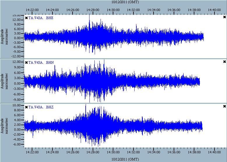
USGS is not showing anything, but it looks like a good deal of movement.
ETA: This is Jonesboro, AR.
Be Well
USGS is not showing anything, but it looks like a good deal of movement.
ETA: This is Jonesboro, AR.
Be Well
edit on 10/12/2011 by Bishop2199 because: (no reason given)
This one just showed up:
Source: USGS
I don't know if this was the same thing I was picking up earlier.
Be Well.
Magnitude
2.1
Date-Time
Wednesday, October 12, 2011 at 16:18:53 UTC
Wednesday, October 12, 2011 at 11:18:53 AM at epicenter
Time of Earthquake in other Time Zones
Location
35.357°N, 92.254°W
Depth
3.6 km (2.2 miles)
Region
ARKANSAS
Distances
4 km (3 miles) SW (231°) from Quitman, AR
8 km (5 miles) ENE (64°) from Guy, AR
14 km (9 miles) E (94°) from Damascus, AR
35 km (22 miles) NNE (31°) from Conway, AR
69 km (43 miles) N (6°) from Little Rock, AR
405 km (252 miles) SSW (207°) from St. Louis, MO
Location Uncertainty
horizontal +/- 0.5 km (0.3 miles); depth +/- 0.6 km (0.4 miles)
Parameters
NST= 11, Nph= 17, Dmin=6 km, Rmss=0.17 sec, Gp=112°,
M-type=duration magnitude (Md), Version=A
Source
Cooperative New Madrid Seismic Network
Event ID
nm101211d
Source: USGS
I don't know if this was the same thing I was picking up earlier.
Be Well.
Hey Robin looks like the cooler temperatures are giving a bit of havoc. Are we back into "swarm season"? If compared to last spring, when temps
were above 50 degrees the rumbles slowed. Now that fall is setting in it appears to be starting up again.
Your thoughts on this phenomenon?
Your thoughts on this phenomenon?
reply to post by Bishop2199
It may be a train. It's not an earthquake. And it's not the 2.1M. I was watching GEE earlier. But it drives me crazy. It's quiet at the moment. Though a storm passed through earlier.
It may be a train. It's not an earthquake. And it's not the 2.1M. I was watching GEE earlier. But it drives me crazy. It's quiet at the moment. Though a storm passed through earlier.
reply to post by SunflowerStar
I don't think temperatures have much to do with the activity directly. The new swarm is the fault getting longer. They're fracking in Quitman and there's quakes. The connection is too direct to consider much else. I'm discounting the moon which I could make a case for. But, I'm too concerned about the new assessment of maximum magnitude.
I said it earlier on Quake Watch, I think they'll be a 4+M soon. Virginia still shaking it out. Same as Colorado. I looked at the epicenter of a Colorado quake recently. It's surround by wells. Not sure what kind though.
Have to run.
The New Madrid seismic zone seems to be chiming in...and Quitman, Arkansas continues on.
Source
USGS
MAP 2.0 2011/10/13 11:39:46 36.571 -89.612 5.4 1 km ( 1 mi) WNW of Howardville, MO
MAP 2.5 2011/10/13 10:07:49 35.363 -92.278 4.9 6 km ( 4 mi) WSW of Quitman, AR
MAP 1.9 2011/10/13 06:27:38 36.154 -89.433 10.0 13 km ( 8 mi) SSE of Ridgely, TN
Source
USGS
I know this sounds crazy, but over the last hour I have been hearing these loud booms(rumble for 1 sec.)
Butter cookie.......can you confirm?
Ooops....I am in Memphis Tn.
Butter cookie.......can you confirm?
Ooops....I am in Memphis Tn.
Originally posted by radpetey
I know this sounds crazy, but over the last hour I have been hearing these loud booms(rumble for 1 sec.)
Butter cookie.......can you confirm?
Ooops....I am in Memphis Tn.
Hey Radpetey!!
I've been inside the last few hours and the kids are playing video games, so i couldn't hear anything.
However, I am feeling that 'rolling' feeling again....I'll let you know if I start to hear those sounds.
reply to post by StealthyKat
I will try to set something up.......but I have not heard any in the last couple hours.
I will try to set something up.......but I have not heard any in the last couple hours.
new topics
-
I hate dreaming
Rant: 40 minutes ago -
Is the origin for the Eye of Horus the pineal gland?
Philosophy and Metaphysics: 2 hours ago -
Man sets himself on fire outside Donald Trump trial
Mainstream News: 2 hours ago -
Biden says little kids flip him the bird all the time.
2024 Elections: 2 hours ago -
The Democrats Take Control the House - Look what happened while you were sleeping
US Political Madness: 3 hours ago -
Sheetz facing racial discrimination lawsuit for considering criminal history in hiring
Social Issues and Civil Unrest: 3 hours ago -
In an Historic First, In N Out Burger Permanently Closes a Location
Mainstream News: 5 hours ago -
MH370 Again....
Disaster Conspiracies: 5 hours ago -
Are you ready for the return of Jesus Christ? Have you been cleansed by His blood?
Religion, Faith, And Theology: 8 hours ago -
Chronological time line of open source information
History: 9 hours ago
top topics
-
In an Historic First, In N Out Burger Permanently Closes a Location
Mainstream News: 5 hours ago, 14 flags -
The Democrats Take Control the House - Look what happened while you were sleeping
US Political Madness: 3 hours ago, 10 flags -
Thousands Of Young Ukrainian Men Trying To Flee The Country To Avoid Conscription And The War
Other Current Events: 15 hours ago, 8 flags -
A man of the people
Medical Issues & Conspiracies: 10 hours ago, 8 flags -
Man sets himself on fire outside Donald Trump trial
Mainstream News: 2 hours ago, 7 flags -
Biden says little kids flip him the bird all the time.
2024 Elections: 2 hours ago, 6 flags -
4 plans of US elites to defeat Russia
New World Order: 12 hours ago, 4 flags -
Is the origin for the Eye of Horus the pineal gland?
Philosophy and Metaphysics: 2 hours ago, 4 flags -
Are you ready for the return of Jesus Christ? Have you been cleansed by His blood?
Religion, Faith, And Theology: 8 hours ago, 3 flags -
Sheetz facing racial discrimination lawsuit for considering criminal history in hiring
Social Issues and Civil Unrest: 3 hours ago, 3 flags
active topics
-
Thousands Of Young Ukrainian Men Trying To Flee The Country To Avoid Conscription And The War
Other Current Events • 30 • : Consvoli -
12 jurors selected in Trump criminal trial
US Political Madness • 96 • : WeMustCare -
The Democrats Take Control the House - Look what happened while you were sleeping
US Political Madness • 25 • : Boogerpicker -
Post A Funny (T&C Friendly) Pic Part IV: The LOL awakens!
General Chit Chat • 7127 • : underpass61 -
Man sets himself on fire outside Donald Trump trial
Mainstream News • 26 • : OnlyYouKnow2 -
Putin Compares Himself to Jesus Promoting Traditional Values Against the Satanic West
Mainstream News • 74 • : DumbNut -
Biden says little kids flip him the bird all the time.
2024 Elections • 11 • : Disgusted123 -
I hate dreaming
Rant • 2 • : FlyersFan -
America's Infant Mortality Rate Increases for the First Time in 20 Years
Medical Issues & Conspiracies • 22 • : BasicResearchMethods -
Is the origin for the Eye of Horus the pineal gland?
Philosophy and Metaphysics • 4 • : JoelSnape