It looks like you're using an Ad Blocker.
Please white-list or disable AboveTopSecret.com in your ad-blocking tool.
Thank you.
Some features of ATS will be disabled while you continue to use an ad-blocker.

Found a Very Interesting Picture... Check It Out
page: 4share:
reply to post by CLPrime
I had not even noticed the mis-spellings.
In fact, Since Google Search auto corrects you, when I searched Techtonic, I guess it auto search Tectonics.
Still think the TinEye search is slightly strange... Wish it would have lead back to a confirmed hoax to ease my mind.
I had not even noticed the mis-spellings.
In fact, Since Google Search auto corrects you, when I searched Techtonic, I guess it auto search Tectonics.
Still think the TinEye search is slightly strange... Wish it would have lead back to a confirmed hoax to ease my mind.
There was some guy claiming to be a psychic a few years back that had a map that looked quite similar to this, predicting major flooding in the
mainland USA after some sort of planetary wide upheaval. It might have been Gordon Michael Scallion.
Edgar Cayce also predicted widespread flooding due to some unforeseen natural disaster, and also eerily enough predicted "a large volcano in Iceland will erupt in 2010".
Edgar Cayce also predicted widespread flooding due to some unforeseen natural disaster, and also eerily enough predicted "a large volcano in Iceland will erupt in 2010".
i've seen that map before seems like sylvia brown was doing an inview and showed it.... please dont ask i was watching her it was 4am and i was 8
(19years ago) she was talking about the end of days.
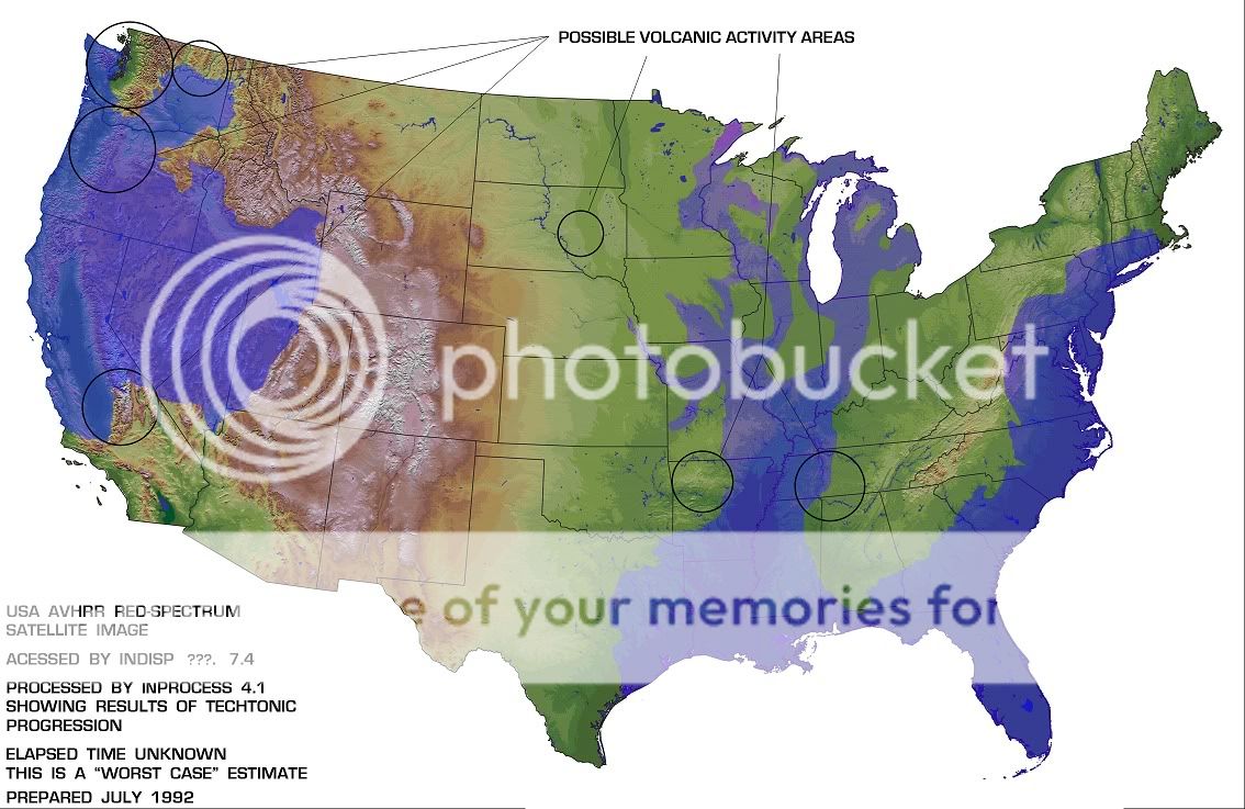
Funny this map doesn't include Yellowstone, the BIGGEST volcano in the U.S.
reply to post by ANNED
...thx for the info - very interesting - and, yeah, i hope they're wrong about the volcanic activity cuz that would really suck for you... actually, they gotta be wrong cuz why would the navy pick a potentially super hazardous site?... i dont think they would...
...thx for the info - very interesting - and, yeah, i hope they're wrong about the volcanic activity cuz that would really suck for you... actually, they gotta be wrong cuz why would the navy pick a potentially super hazardous site?... i dont think they would...
I don't like that I live in the very center of one of the ominous circles on the map.
I dont mean to be diminutive, but most of you have mentioned the exact reason behind the culprit of the damage in this map. None of you however have
delved into any explanation however.
I rarely post, but seeing as how this thread has gone 4 pages without a good explanation, and I've watched everything from "government conspiracies" to "reptilians are responsible" in this thread as a reason, I'm going to post and clear this up, perhaps even start a new thread to debunk this fear once and for all, as this image and other images like it have been the subject of many a thread lately with the impending "pole-shift", causing much unnecessary fear.
Please watch this post, as ill edit it with the new thread link once I'm done. hopefully ill be done in an hour or so as of posting this.
HERES THE LINK; Enjoy a rational explanation to our nations watery grave LINK
edit 1: I just realized that this thread is in the wrong forums, so mods may want to move it to fragile earth.
edit on 12-2-2011 by beachguy123
because: thread in wrong forum, stating the obvious
edit on 13-2-2011 by beachguy123 because: (no reason given)
reply to post by 9Cib27
I've seen lots of pictures with estimations as to what the "new coast lines" would be.. if water levels rise, nearly all low lying areas will be turned into shallow seas.
How do we know this?
Most of the US was once a shallow sea, from fossil records anyways. It was those damned Dino's and their escalades that did it.
So, I did up a more explicit version of the map...
It's not exact, but it's hard to see the extent of the new coastline in some areas, so I had to guess and/or blindly follow the true elevation in some spots.
As has already been noted, AVHRR is NOAA's Advanced Very High Resolution Radiometer.
Also, inProcess is a mapping program: inProcess
It's not exact, but it's hard to see the extent of the new coastline in some areas, so I had to guess and/or blindly follow the true elevation in some spots.
As has already been noted, AVHRR is NOAA's Advanced Very High Resolution Radiometer.
Also, inProcess is a mapping program: inProcess
This looks like one of Gordon Michael Scallion's maps of a future United States.
reply to post by Rockpuck
Exactly, people have been making these predictions for a long time. My grandpa told me about the US splitting apart at the mississippi when I was a little kid. here in Edgar Cayce country, Old Timers can tell you this.
Cayce died in the 1940's and Hopkinsville KY is underwater here.
cool looking map though....
what can you do?
get a boat, swim or run for higher ground.
reply to post by 9Cib27
What did you "notice" of its authenticity.
There is nothing on that file that i can see to suggest its origin so throwing the word authenticity around seems a bit of a leap of faith.
One I won't make.
What did you "notice" of its authenticity.
There is nothing on that file that i can see to suggest its origin so throwing the word authenticity around seems a bit of a leap of faith.
One I won't make.
I never really liked Houston anyways, but all joking aside, I need to get some money and head for the mountains soon. All of this data coming up about
the pole shifts has me somewhat worried. Oh well, I feel as if surviving the Universe would be a walk in the park compared to any man made threat.
s&f
s&f
edit on 13-2-2011 by CordDragonzord because: (no reason given)
reply to post by Alucard666
Why would an 8 year old be watching tv at 4am and remember such a trivial detail from 20 years ago?
Why would an 8 year old be watching tv at 4am and remember such a trivial detail from 20 years ago?
Originally posted by phoenix103
reply to post by Alucard666
Why would an 8 year old be watching tv at 4am and remember such a trivial detail from 20 years ago?
Yeah the idea of the USA splitting in half and the coastline changing is trivial? LOL
How could an 8 year old forget getting the crap scared out of him/her?
I was about 7 or 8 when my grandpa told me about the predictions and I remember it well, that was almost 40 years ago.
edit on 13-2-2011 by
kimsie because: ooops getting old maybe
Originally posted by BruceWayne
Very interesting.
Looks Like Denver would be alright then...
That may be why the CIA are moving their offices there and strengthens the rumours of a DUMB at Denver airport
PEACE,
RK
Originally posted by troubleshooter
No more flood...
"And I will establish my covenant with you; neither shall all flesh be cut off any more by the waters of a flood; neither shall there any more be a flood to destroy the earth. 12 And God said, This is the token of the covenant which I make between me and you and every living creature that is with you, for perpetual generations: 13 I do set my bow in the cloud, and it shall be for a token of a covenant between me and the earth. 14 And it shall come to pass, when I bring a cloud over the earth, that the bow shall be seen in the cloud: 15 And I will remember my covenant, which is between me and you and every living creature of all flesh; and the waters shall no more become a flood to destroy all flesh. 16 And the bow shall be in the cloud; and I will look upon it, that I may remember the everlasting covenant between God and every living creature of all flesh that is upon the earth. 17 And God said unto Noah, This is the token of the covenant, which I have established between me and all flesh that is upon the earth." Genesis 9:11-17
...so you can stop worrying about that one.
edit on 13-2-2011 by NEWclearMind because: To add that he said he would not flood ALL of the earth, that doesn't mean he won't
flood some of the earth.
reply to post by NEWclearMind
Technically, this flooding isn't going to cover the earth, just parts of the extended coastline. Sorry, but no bible-thumping on this natural threat.
Glad I'm in Ohio... seems I should be alright here, or in Tucson. That's another place I would consider home
@NEWclearMind - Hey, sorry man. I didn't realize that you were making the part about "whole earth" flooding bold to prove a point. My bad... and good job on pointing that out. It was the first thing I noticed when reading it.
edit on 2/13/2011 by Seitler because: Props to NEWclearMind
reply to post by 9Cib27
OK, two problems without even thinking about it -
1 - The area under Yellowstone National Park is the largest volcano in US. It is not indicated on this map.
2 - The correct spelling is TECTONIC, not TECHTONIC.
I smell fish.
OK, two problems without even thinking about it -
1 - The area under Yellowstone National Park is the largest volcano in US. It is not indicated on this map.
2 - The correct spelling is TECTONIC, not TECHTONIC.
I smell fish.
So you find a supposedly government picture projecting the future of the united states coastline, and they happen to misspell "tectonic". And
they spell it the same as you.
What's the chances eh?
What's the chances eh?
new topics
-
Supreme Court Oral Arguments 4.25.2024 - Are PRESIDENTS IMMUNE From Later Being Prosecuted.
Above Politics: 1 hours ago -
Krystalnacht on today's most elite Universities?
Social Issues and Civil Unrest: 1 hours ago -
Chris Christie Wishes Death Upon Trump and Ramaswamy
Politicians & People: 1 hours ago -
University of Texas Instantly Shuts Down Anti Israel Protests
Education and Media: 4 hours ago -
Any one suspicious of fever promotions events, major investor Goldman Sachs card only.
The Gray Area: 6 hours ago -
God's Righteousness is Greater than Our Wrath
Religion, Faith, And Theology: 10 hours ago
top topics
-
VP's Secret Service agent brawls with other agents at Andrews
Mainstream News: 15 hours ago, 11 flags -
Nearly 70% Of Americans Want Talks To End War In Ukraine
Political Issues: 16 hours ago, 6 flags -
Sunak spinning the sickness figures
Other Current Events: 15 hours ago, 5 flags -
Supreme Court Oral Arguments 4.25.2024 - Are PRESIDENTS IMMUNE From Later Being Prosecuted.
Above Politics: 1 hours ago, 4 flags -
Electrical tricks for saving money
Education and Media: 13 hours ago, 4 flags -
Krystalnacht on today's most elite Universities?
Social Issues and Civil Unrest: 1 hours ago, 3 flags -
Late Night with the Devil - a really good unusual modern horror film.
Movies: 17 hours ago, 3 flags -
Any one suspicious of fever promotions events, major investor Goldman Sachs card only.
The Gray Area: 6 hours ago, 2 flags -
University of Texas Instantly Shuts Down Anti Israel Protests
Education and Media: 4 hours ago, 2 flags -
Chris Christie Wishes Death Upon Trump and Ramaswamy
Politicians & People: 1 hours ago, 1 flags
active topics
-
Sunak spinning the sickness figures
Other Current Events • 18 • : andy06shake -
British TV Presenter Refuses To Use Guest's Preferred Pronouns
Education and Media • 155 • : Annee -
University of Texas Instantly Shuts Down Anti Israel Protests
Education and Media • 87 • : CriticalStinker -
Nearly 70% Of Americans Want Talks To End War In Ukraine
Political Issues • 76 • : FlyersFan -
The Reality of the Laser
Military Projects • 49 • : 5thHead -
Supreme Court Oral Arguments 4.25.2024 - Are PRESIDENTS IMMUNE From Later Being Prosecuted.
Above Politics • 2 • : xuenchen -
President BIDEN Vows to Make Americans Pay More Federal Taxes in 2025 - Political Suicide.
2024 Elections • 142 • : xuenchen -
Chris Christie Wishes Death Upon Trump and Ramaswamy
Politicians & People • 6 • : mysterioustranger -
"We're All Hamas" Heard at Columbia University Protests
Social Issues and Civil Unrest • 282 • : 5thHead -
Candidate TRUMP Now Has Crazy Judge JUAN MERCHAN After Him - The Stormy Daniels Hush-Money Case.
Political Conspiracies • 745 • : network dude