It looks like you're using an Ad Blocker.
Please white-list or disable AboveTopSecret.com in your ad-blocking tool.
Thank you.
Some features of ATS will be disabled while you continue to use an ad-blocker.

Cracking an eggshell?
page: 5share:
Originally posted by randomname
to put it in perspective, an earthquake in toronto is about as common as snow in death valley during summer.
...wasnt there two quakes near toronto in 2010?... one in june and another in october?... maybe my memory is faulty (again), lol...
www.vancouversun.com...
Recent earthquakes in Ontario and Quebec:
- June 23, 2010 — 5.0 magnitude quake. Epicentre was 61 km north of Ottawa.
- Feb. 24, 2006 — 4.5 magnitude quake. Epicentre was seven kilometres north of Thurso, Que.
- Jan. 1, 2000 — 5.2 magnitude quake. Epicentre was 70 km northeast of North Bay.
- Oct. 19, 1990 — 5.0 magnitude quake. Epicentre was nine km southwest of Mont-Laurier, Que.
- Dec. 25, 1989 — 5.9 magnitude quake in northern Quebec.
- Nov. 1, 1935 — 6.2 magnitude quake. Epicentre was about 10 km east of Temiscaming, Que.
The heartlands lost volcanoes,
www.showme.net...
energy.usgs.gov...
Hicks Dome was created by a volcano nearly 150,000,000 although it never broke the surface causing the bulging (crypto-explosion). Pilots flying over this hill are amazed to see the shape of a volcano from the air.
The region is sedimentary rocks as well as some igenious outcroppings with many fauts and unusual surface formations to see.
www.illinoisbeautiful.com...
books.google.com... Enhu9V68MU&hl=en&ei=DqUfTenVNITJnAf134inDg&sa=X&oi=book_result&ct=result&resnum=2&ved=0CBoQ6AEwAQ#v=onepage&q&f=false
pages.cs.wisc.edu...
THE LARGEST SO-CALLED METEORITE SCARS IN THREE CONTINENTS AS DEMONSTRABLY TIED TO MAJOR TERRESTRIAL STRUCTURES
onlinelibrary.wiley.com...
Look at the location of Hicks dome and your maps
www.mindat.org...
Just something i found about the Floods in Queensland. Is there any truth to that?
Source
If the Indo-Australian Plate is not only tilting up on its eastern side but also tipping sideways to raise the curve just under Java and Sumatra, what would this do to relieve pressure in the small platelets just above New Guinea? Here three great plates meet, so the little platelets are fragments very much susceptible to changes in any arrangement the larger plates make. The tipping of the Indo-Australia Plate has allowed this platelet to drop where before it was under pressure from the Pacific, and snagged at the edges, thus lifted with the Indo-Australian Plate.
Source
reply to post by Stormdancer777
All that would fit with what I am seeing elsewhere... Hicks Dome is located precisely where I would expect volcanic activity to have been present in the past, around the end of the New Madrid Fault.
The more I study this region, the more I think maybe I am correct at least as to the location of potential weakness. Lets just all hope I am wrong about the effects of BP. Only time will tell.
TheRedneck
reply to post by TheRedneck
The liquefaction makes the area more conducive to damage. Liquefaction causes increased damage to buildings, that otherwise might not be damaged in light to moderate quakes. This is because the liquefaction basically turns the soil to a pudding-like substance, and foundations settle unevenly, then crack and then collapse. Likewise liquefaction causes more damage to civil infrastructure items such as gas lines, electrical lines and sewer lines. The Alaskan quake of 1964 was an example of what an earthquake that causes soil liquefaction can do.
en.wikipedia.org...
I'm not sure where liquefaction plays into this scenario, though.
The liquefaction makes the area more conducive to damage. Liquefaction causes increased damage to buildings, that otherwise might not be damaged in light to moderate quakes. This is because the liquefaction basically turns the soil to a pudding-like substance, and foundations settle unevenly, then crack and then collapse. Likewise liquefaction causes more damage to civil infrastructure items such as gas lines, electrical lines and sewer lines. The Alaskan quake of 1964 was an example of what an earthquake that causes soil liquefaction can do.
en.wikipedia.org...
The powerful earthquake produced earthquake liquefaction in the region. Ground fissures and failures caused major structural damage in several communities, much damage to property and several landslides. Anchorage sustained great destruction or damage to many inadequately engineered houses, buildings, and infrastructure (paved streets, sidewalks, water and sewer mains, electrical systems, and other man-made equipment), particularly in the several landslide zones along Knik Arm. Two hundred miles southwest, some areas near Kodiak were permanently raised by 30 feet (9.1 m). Southeast of Anchorage, areas around the head of Turnagain Arm near Girdwood and Portage dropped as much as 8 feet (2.4 m), requiring reconstruction and fill to raise the Seward Highway above the new high tide mark.
edit on 1-1-2011 by ProfEmeritus because: (no reason given)
reply to post by TheRedneck
imho - Fractures in the earth can heal, just like fractured bones can.
BUT.
If there's another trauma before the fracture heals, it will get worse. How much worse depends on the force of the new trauma. In this case, I'd say everything from volcanic activity and earthquakes qualifies as 'trauma' - even if they're on the other side of the planet. ...drilling, testing and any kind of man-made seismic stress also fit the bill... (I'm thinking war and bombs here).
Everything is connected, and you've done a great job showing this part of the "system."
reply to post by ProfEmeritus
OK, that I can understand. My first impression was that you were suggesting liquefaction as a contributor to the geologic damage to the fault rather than the surface damage to the surroundings. Sorry for that misunderstanding.
I read somewhere a while back in a thread about an eastern US quake that the damage was greater than in the West due to geology differences, but I hadn't considered the effect liquefaction has on that damage until now. It makes a lot of sense.
TheRedneck
reply to post by TheRedneck
Right. Liquefaction must most probably the geological factor that they were talking about.
I read somewhere a while back in a thread about an eastern US quake that the damage was greater than in the West due to geology differences, but I hadn't considered the effect liquefaction has on that damage until now. It makes a lot of sense
Right. Liquefaction must most probably the geological factor that they were talking about.
This thread is erudite, well thought out and absolutely excellent. I went on the interweb, to the USGS and NOAA, what a wasteland of excuses for not
using predictive engines. You have it all over them. You should be running them.
I am California born and raised and have lived through a couple hellacious earthquakes. But, we know, as Californians, we need the little ones (earthquakes) and a lot of them on all three major fault lines. And we live and breath by Caltech.
Your epicenter studies, your comments and other poster's insights are fascinating. When I was growing up, the California Coast was oil country offshore and on. No more, except way way offshore. Of late our epicenters have been very strange. They used to almost always be off shore or within a mile or two of the coast. But now, epicenters in Whittier and El Centro, that's the middle of the desert. I have to find out what that means and if you all know please write me. Californians walk around waiting for the "Big One". It's ingrained, we use denial as our modus operandi.
Thanks so much, you have really got me thinking.
The Great Nebraska Sea!
en.wikipedia.org...
The story begins with an account of how geologists in the mid-1960s came to understand that the "Kiowa fault" in the state of Colorado was actually part of a larger fault system running along the eastern edge of the Rocky Mountains from Texas to the Canadian border. In the summer of 1973 the land east of the fault slips downward, slowly but inexorably over the next few months, until the major rivers of the region (including the Mississippi) flood the new lowlands. The process is slow enough for people to flee eastwards, though conditions become more and more hazardous as the flooding increases. The story recounts how, during this time the various authorities such as the Federal government and the State governors, try to quell panic by invoking patriotism or, in the case of the governors, the stalwart nature of the people of the "great Southland". However the next act of nature proves even more cataclysmic. The Gulf coast of the United States, from western Florida to Lake Ponchartrain, simply sinks below sea level. The sea floods the new lowlands from the Texas Panhandle to North Dakota. As many as 14 million people perish. The state of Oklahoma is completely lost, as are most of the Dakotas, Kansas, Nebraska, and Arkansas. The Ozarks become an archipelago.
en.wikipedia.org...
Very detailed and thought out. Thank you for posting this. Whether it happens or not, or you believe it will or not. Having the information can only
help.
Britain just had an Earthquake
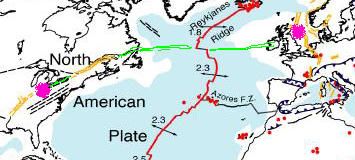
Follow the line from the St. Lawrence River across the anomaly in the Mid-Atlantic Rift... it heads straight into the UK, connecting to the area where this 3.6 occurred. I found a world map of fault lines and snipped the applicable section of it out to show here. They show the New Madrid and St. Lawrence lines, as well as the North Sea fault, in yellow, indicating a "normal fault" according to the legend. I connected the first two across the Midwest in green, then extended the St. Lawrence out to the rift anomaly and across... it is in line with the UK.
I show the approximate locations of the Indiana and North Sea quakes in pink.
Coincidence? Triggered by the Indiana quake? I dunno, but I am watching this line...
TheRedneck
reply to post by TheRedneck
Isn't it interesting how everything is just so connected?
My my. And yet so many are continually surprised.
Isn't it interesting how everything is just so connected?
My my. And yet so many are continually surprised.
I find the Cayce map and the other map to be fascinating. I wish there was a way to make the psychic's map larger because it's still hard to read,
even at 2x the size.
I just want to get some idea of what could happen if certain areas were to go underwater.
Regardless, star and flag for an excellent thread.
I just want to get some idea of what could happen if certain areas were to go underwater.
Regardless, star and flag for an excellent thread.
reply to post by TheRedneck
Most of us likely know little about earthquakes.
That's why it's good for people to engage in a conversation and as we go along, we get "schooled" by those who know more or question the theory.
Most of us likely know little about earthquakes.
That's why it's good for people to engage in a conversation and as we go along, we get "schooled" by those who know more or question the theory.
reply to post by TheRedneck
You did not mention the Wabash Valley fault in southern Illinois.
It is not new. It been there for millions of years. Along with all the coal, oil and dinosaur bones. Wabash valley has a good shaker every couple of years or so and we are due for one again, I would guess.
Going back 100 years of generations people have talked about the US splitting apart at the Wabash up to chicago sandwich fault and draining lake michigan into the gulf.
that is no new prediction but the thing I find interesting is, I live in Indiana, about 200 miles south of Kokomo and watch the news everyday.
I heard about the earthquake 2 days afterward from a facebook friend in california.
Also interesting to note... The Wabash begins it's journey to the Gulf near Kokomo, IN area.
just sayin

reply to post by kimsie
btw... this sign is real located on the bank of the Ohio near Cave-in-Rock, Illinois
btw... this sign is real located on the bank of the Ohio near Cave-in-Rock, Illinois
reply to post by kimsie
I'm not sure what you're referring here to or if this is sarcasm or what?
I'm looking for answers, not pointless images with no words.
I'm not sure what you're referring here to or if this is sarcasm or what?
I'm looking for answers, not pointless images with no words.
new topics
-
Thousands Of Young Ukrainian Men Trying To Flee The Country To Avoid Conscription And The War
Other Current Events: 1 hours ago -
12 jurors selected in Trump criminal trial
US Political Madness: 4 hours ago -
Iran launches Retalliation Strike 4.18.24
World War Three: 4 hours ago -
Israeli Missile Strikes in Iran, Explosions in Syria + Iraq
World War Three: 5 hours ago -
George Knapp AMA on DI
Area 51 and other Facilities: 10 hours ago -
Not Aliens but a Nazi Occult Inspired and then Science Rendered Design.
Aliens and UFOs: 10 hours ago
top topics
-
BREAKING: O’Keefe Media Uncovers who is really running the White House
US Political Madness: 17 hours ago, 26 flags -
George Knapp AMA on DI
Area 51 and other Facilities: 10 hours ago, 25 flags -
Israeli Missile Strikes in Iran, Explosions in Syria + Iraq
World War Three: 5 hours ago, 14 flags -
Louisiana Lawmakers Seek to Limit Public Access to Government Records
Political Issues: 13 hours ago, 7 flags -
Iran launches Retalliation Strike 4.18.24
World War Three: 4 hours ago, 6 flags -
So I saw about 30 UFOs in formation last night.
Aliens and UFOs: 16 hours ago, 6 flags -
Not Aliens but a Nazi Occult Inspired and then Science Rendered Design.
Aliens and UFOs: 10 hours ago, 5 flags -
Do we live in a simulation similar to The Matrix 1999?
ATS Skunk Works: 17 hours ago, 5 flags -
12 jurors selected in Trump criminal trial
US Political Madness: 4 hours ago, 4 flags -
The Tories may be wiped out after the Election - Serves them Right
Regional Politics: 14 hours ago, 3 flags
active topics
-
Do we live in a simulation similar to The Matrix 1999?
ATS Skunk Works • 22 • : SchrodingersRat -
Iran launches Retalliation Strike 4.18.24
World War Three • 15 • : semperfortis -
Russia Ukraine Update Thread - part 3
World War Three • 5696 • : Kenzo -
President BIDEN Warned IRAN Not to Attack ISRAEL - Iran Responded with a Military Attack on Israel.
World War Three • 43 • : WeMustCare -
Israeli Missile Strikes in Iran, Explosions in Syria + Iraq
World War Three • 52 • : WeMustCare -
Mandela Effect - It Happened to Me!
The Gray Area • 107 • : inflaymes69 -
Terrifying Encounters With The Black Eyed Kids
Paranormal Studies • 45 • : daskakik -
Not Aliens but a Nazi Occult Inspired and then Science Rendered Design.
Aliens and UFOs • 12 • : BeyondKnowledge3 -
Elites disapearing
Political Conspiracies • 31 • : Degradation33 -
MULTIPLE SKYMASTER MESSAGES GOING OUT
World War Three • 47 • : SchrodingersRat