It looks like you're using an Ad Blocker.
Please white-list or disable AboveTopSecret.com in your ad-blocking tool.
Thank you.
Some features of ATS will be disabled while you continue to use an ad-blocker.

Quake Watch 2011
page: 404share:
update on post by muzzy
yep its gone from GFZ
geofon.gfz-potsdam.de...
EMSC have it on their "use at your own risk" data contributions as;
2011-12-21 13:45:27.6 44.37 N 173.59 E 33 mb 5.6 A NORTH PACIFIC OCEAN LDG
2011-12-21 13:45:02.8 38.55 N 169.75 E 10 M 5.8 A NORTH PACIFIC OCEAN GFZ
but they never listed it on their main lists.
both quite different locations.
I think they been playing pin the tail on the donkey blindfolded
oh and that Kermy 5.7 quake was felt in Auckland
www.geonet.org.nz...
edit on 21-12-2011 by muzzy because: (no reason given)
just catching up after not downloading NZ data for 3 days, due to having to get work finished before the Christmas Break, been pretty quiet except for
this swarm SW corner of Mt Tihia, Tongariro National Park, North Island.
map
we get a few swarms at Mt. Tihia, but not usually in this corner.
Nothing major, was 2 sequences over 2 days, all micro size.
map
we get a few swarms at Mt. Tihia, but not usually in this corner.
Nothing major, was 2 sequences over 2 days, all micro size.
I see LISS just had a revamp
earthquake.usgs.gov...
I like it, a lot easier to find your station on the white background.
I didn't realise until I opened my SNZO and it looked different, thought my computer was playing up on me.The text is bigger on the time side and the traces slightly lighter.
Kind of looks like the new page I started showing previously saved SNZO graphs
edit on 21-12-2011 by muzzy because: (no reason given)
Where did everyone go
Stuck in traffic? last minute shopping? gone on holiday
I'll keep the Topic ticking
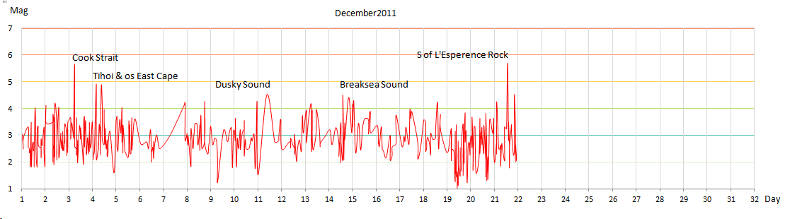
See that 5.7 south of L'Esperence Rock DOUBLED the energy released for New Zealand for December in one hit
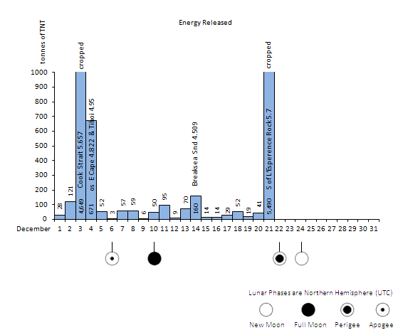
but still on the low side.
recent months to compare with
or looking at it another way Timeline v Magnitude

Stuck in traffic? last minute shopping? gone on holiday
I'll keep the Topic ticking
See that 5.7 south of L'Esperence Rock DOUBLED the energy released for New Zealand for December in one hit
but still on the low side.
recent months to compare with
or looking at it another way Timeline v Magnitude
edit on 22-12-2011 by muzzy because: (no reason given)
Muzzy, you sound so 'ronery'...(KJI reference BTW).
Everyone's out shopping for Xmas mate
Everyone's out shopping for Xmas mate
reply to post by SpaceJockey1
not organised eh?
2 years ago I left it to the last minute and then couldn't even get a car park anywhere within a km of the shopping mall, ended up the best I could do was get a card from the local newsagent and promise we would hit the sales after Boxing day.
Last 2 years I got my gifts way back in June
reply to post by muzzy
I just noticed. This page is 404 but it is still here!!
Don't like the new LISS - way too bright and I can hardly make out the smaller writing on the bright white background. It is just too much white all on one page. They could have gone to an off white. Sorry but I have emailed them to tell them what I think. Don't suppose it will achieve anything but you never know.
I was going to upload a graph but I have tried 5 time now and failed. Oh well. Try again later perhaps.
Magnitude
5.8
Date-Time
Friday, December 23, 2011 at 00:58:36 UTC
Friday, December 23, 2011 at 01:58:36 PM at epicenter
Time of Earthquake in other Time Zones
Location
43.489°S, 172.977°E
Depth
4.7 km (2.9 miles)
Region
SOUTH ISLAND OF NEW ZEALAND
Distances
26 km (16 miles) ENE of Christchurch, New Zealand
223 km (138 miles) SSE of Westport, New Zealand
284 km (176 miles) SSW of WELLINGTON, New Zealand
329 km (204 miles) NE of Dunedin, New Zealand
Location Uncertainty
horizontal +/- 13.5 km (8.4 miles); depth +/- 2 km (1.2 miles)
Parameters
NST= 74, Nph= 75, Dmin=30.1 km, Rmss=1 sec, Gp= 94°,
M-type=regional moment magnitude (Mw), Version=7
Source
Magnitude: USGS NEIC (WDCS-D)
Location: USGS NEIC (WDCS-D)
Event ID
usc0007b7t
earthquake.usgs.gov...
Hope all our friends there are OK!
So New Zealand got hit just a few minutes ago.
Hope everyone is safe down there.
5.8
Date-Time Friday, December 23, 2011 at 00:58:36 UTC Friday, December 23, 2011 at 01:58:36 PM at epicenter Time of Earthquake in other Time Zones Location
43.489°S, 172.977°E Depth 4.7 km (2.9 miles) Region SOUTH ISLAND OF NEW ZEALAND
Distances 26 km (16 miles) ENE of Christchurch, New Zealand 223 km (138 miles) SSE of Westport, New Zealand 284 km (176 miles) SSW of WELLINGTON, New Zealand 329 km (204 miles) NE of Dunedin, New Zealand Location Uncertainty horizontal +/- 13.5 km (8.4 miles); depth +/- 2 km (1.2 miles) Parameters NST= 74, Nph= 75, Dmin=30.1 km, Rmss=1 sec, Gp= 94°, M-type=regional moment magnitude (Mw), Version=7 Source Magnitude: USGS NEIC (WDCS-D) Location: USGS NEIC (WDCS-D) Event ID usc0007b7t
Hope everyone is safe down there.
off shore in Pegusus Bay
Panic in the streets
geonet shaking map
Check out the PGA at New Brighton Library = 97.58771%g or MM9
(Click on options on the map and select PGA)
just watching it on TV some further damage but no reports of injuries or deaths
airport, office buildings, shopping malls evacuated
another reason to do your shopping early
bet it brings back memories of last years Boxing day quake
multiple aftershocks, no lists yet but you can see for youreself on the McQueens Valley siesmo
www.geonet.org.nz...
that first aftershock looks qiute big too maybe a 5.0
some graphs off Wilber II
Panic in the streets
geonet shaking map
Check out the PGA at New Brighton Library = 97.58771%g or MM9
(Click on options on the map and select PGA)
just watching it on TV some further damage but no reports of injuries or deaths
airport, office buildings, shopping malls evacuated
another reason to do your shopping early
bet it brings back memories of last years Boxing day quake
multiple aftershocks, no lists yet but you can see for youreself on the McQueens Valley siesmo
www.geonet.org.nz...
that first aftershock looks qiute big too maybe a 5.0
edit on 22-12-2011 by muzzy because: (no reason given)
some graphs off Wilber II
edit on 22-12-2011 by muzzy because: (no reason given)
Here is the latest report.
www.nzherald.co.nz...
There has been a large earthquake in Christchurch this afternoon. The quake was described as "violent" by Herald reporter Jarrod Booker who was in his home when the quake hit. It was quickly followed by at least four strong aftershocks. Geonet said the quake measured 5.8 on the Richter Scale, at a depth of just 8km. It struck just off the coast of Pegasus Bay at 1.58pm. Damage from the quake is unknown, but it was felt as far away as Mosgiel near Dunedin. Reports are coming in that Christchurch International Airport is being evacuated. Phone lines into the city are struggling to cope with the volume of traffic.
www.nzherald.co.nz...
Just found out about this quake.
Hope everyone is alright!
Hope everyone is alright!
edit on 22-12-2011 by crazydaisy because: (no reason given)
Well that was no fun!
Lots of stock thrown from my shop shelves and panic in the Warehouse next to me
Been feeling this brewing and had not long been back in my shop after a walk thru the outskirts of the RED-ZONE. Was thinking all the way that please let there NOT be any quakes over the Xmas shopping period, like Boxing Day 26th Dec last year...
Plenty of liquifcation being reported in parts of the city.
#, just had another HUGE quake!!!!
reply to post by SpaceJockey1
Glad you are OK.
How are the aftershocks? on TV some people are saying the second one felt bigger
for a change USGS are first
5.8 2011/12/23 02:18:02 -43.491 172.844 4.9 SOUTH ISLAND OF NEW ZEALAND
5.3 2011/12/23 01:06:25 -43.456 172.899 3.7 SOUTH ISLAND OF NEW ZEALAND
5.8 2011/12/23 00:58:37 -43.489 172.977 4.7 SOUTH ISLAND OF NEW ZEALAND
earthquake.usgs.gov...
yep the 3rd bigun looks bigger on SNZO
hard to tell on McQueens Valley as Geonet crop those graphs
bit clearer at Rata Peaks in the Alps foothills
Glad you are OK.
How are the aftershocks? on TV some people are saying the second one felt bigger
for a change USGS are first
5.8 2011/12/23 02:18:02 -43.491 172.844 4.9 SOUTH ISLAND OF NEW ZEALAND
5.3 2011/12/23 01:06:25 -43.456 172.899 3.7 SOUTH ISLAND OF NEW ZEALAND
5.8 2011/12/23 00:58:37 -43.489 172.977 4.7 SOUTH ISLAND OF NEW ZEALAND
earthquake.usgs.gov...
edit on 22-12-2011 by muzzy because: (no reason given)
yep the 3rd bigun looks bigger on SNZO
hard to tell on McQueens Valley as Geonet crop those graphs
bit clearer at Rata Peaks in the Alps foothills
edit on 22-12-2011 by muzzy because: (no reason given)
Just gone home and YES the second one was much BIGGER!
I was writing the previous post when it struck. Didn't think I was getting out of my shop without injury but managed to avoid the falling items.
Lots of further aftershocks...not going to be much fun for next 24 or so hours.
Xmas shopping will be MUNTED I'd say.
Lots of cleaning up to do (again), when I go back in to open
Thanks for all the concern guys & gals.
edit on 22-12-2011 by SpaceJockey1 because: spelling
Glad they were no too large and no one killed. That is the main thing. Not good just before Xmas however.
I told Santa NOT to drop the packages from 30,000 ft did he listen, no.
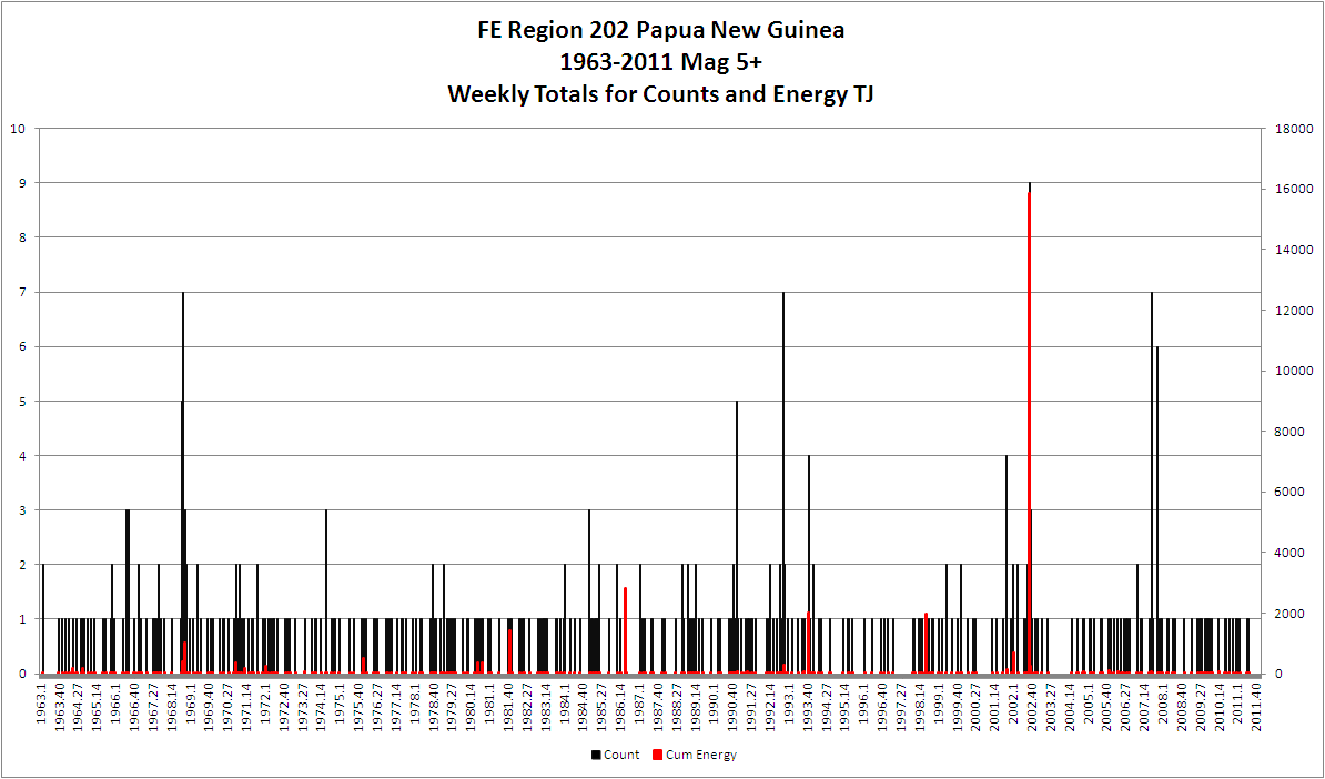
Came on to show you all this
But it sort of seems irrelevant just at present. It is Mag 5+ quakes for the FE Region 202 Papua New Guinea. I have spend all day building an analysis engine and this is the output of the first stage. I can now produce a CSV file for any period from 1963 onwards to currently July 2011 using ANSS data, and it is switchable to Centennial data.
I have sucked the complete ANSS database for Mag 5+ down to my computer and massaged it to create energy values and I have taken all the FE 757 regions and extrapolated a grid in SQL Server instead of using Fortran. Next step is to add the FE 52 regions and be able to produce for that. Then comes the fun bit, extrapolating stress.
I told Santa NOT to drop the packages from 30,000 ft did he listen, no.
Came on to show you all this
But it sort of seems irrelevant just at present. It is Mag 5+ quakes for the FE Region 202 Papua New Guinea. I have spend all day building an analysis engine and this is the output of the first stage. I can now produce a CSV file for any period from 1963 onwards to currently July 2011 using ANSS data, and it is switchable to Centennial data.
I have sucked the complete ANSS database for Mag 5+ down to my computer and massaged it to create energy values and I have taken all the FE 757 regions and extrapolated a grid in SQL Server instead of using Fortran. Next step is to add the FE 52 regions and be able to produce for that. Then comes the fun bit, extrapolating stress.
reply to post by SpaceJockey1
I see USGS has the first 5.8 as a 5.7 in the tensor solution
earthquake.usgs.gov...
If the second quake was bigger look for a large figure when the tensor solution shows up. They are usually better than the main web page.
I am off to my bed.
Be safe people and goodnight.
I see USGS has the first 5.8 as a 5.7 in the tensor solution
earthquake.usgs.gov...
If the second quake was bigger look for a large figure when the tensor solution shows up. They are usually better than the main web page.
I am off to my bed.
Be safe people and goodnight.
Originally it was stated that they were both 5.8 and out on the ocean but GeoNet is now showing the 2nd as a 6.0 and right on Sumner and only 8 km's
from the city (the first was 20km's and in the ocean).
They're evacuating residents of Sumner
They're evacuating residents of Sumner
reply to post by PuterMan
I just had to look and see what that 2002 spike was
So Irian Jaya is in the FE 202 Region along with Papua New Guinea then.
I can't believe no one has done a map of the FE regions yet ( all the links I found Googling it you had to pay to download the pdf)
Geonet just gave the 2nd big one a 6.0
usgs tensor have 5.9Mw and as you say in your other post 5.7Mw for the first one
I just had to look and see what that 2002 spike was
8.2
Date/Time: 2002/10/10 10:50:20.5
Lat: -1.757 Long: 134.297
Region: o/s Rumberpon is, Irian Jaya, Indonesia
Mw: 7.6 Ms: 7.7
Mb: 6.5 ML: n/a
Me: 8.2 Unk:
Depth: 10 km
Deaths: 8 , Injuries: 632
Tsunami: Yes
Source: noaa
Eight people killed, at least 632 injured, more than 1,000 houses destroyed or severely damaged and about 900 buildings partially damaged in the Manokwari- Oransbari-Ransiki area. Landslides blocked roads in the area. A surface fault 3 km long occurred at Ransiki. Many houses were flooded by a local tsunami with estimated wave heights of 3 to 5 meters at Oransbari and Ransiki and 1 meter at Manokwari. Liquefaction occurred along the coast at Manokwari, Oransbari and Ransiki and subsidence of approximately 2 to 3 meters observed at Oransbari. Felt (IV) at Biak, Sorong and Timika; (III) at Nabire and Wamena.
So Irian Jaya is in the FE 202 Region along with Papua New Guinea then.
I can't believe no one has done a map of the FE regions yet ( all the links I found Googling it you had to pay to download the pdf)
Geonet just gave the 2nd big one a 6.0
usgs tensor have 5.9Mw and as you say in your other post 5.7Mw for the first one
edit on 22-12-2011 by muzzy because: (no reason
given)
new topics
-
The functionality of boldening and italics is clunky and no post char limit warning?
ATS Freshman's Forum: 30 minutes ago -
Meadows, Giuliani Among 11 Indicted in Arizona in Latest 2020 Election Subversion Case
Mainstream News: 1 hours ago -
Massachusetts Drag Queen Leads Young Kids in Free Palestine Chant
Social Issues and Civil Unrest: 1 hours ago -
Weinstein's conviction overturned
Mainstream News: 2 hours ago -
Supreme Court Oral Arguments 4.25.2024 - Are PRESIDENTS IMMUNE From Later Being Prosecuted.
Above Politics: 4 hours ago -
Krystalnacht on today's most elite Universities?
Social Issues and Civil Unrest: 4 hours ago -
Chris Christie Wishes Death Upon Trump and Ramaswamy
Politicians & People: 4 hours ago -
University of Texas Instantly Shuts Down Anti Israel Protests
Education and Media: 6 hours ago -
Any one suspicious of fever promotions events, major investor Goldman Sachs card only.
The Gray Area: 9 hours ago
top topics
-
VP's Secret Service agent brawls with other agents at Andrews
Mainstream News: 17 hours ago, 11 flags -
Krystalnacht on today's most elite Universities?
Social Issues and Civil Unrest: 4 hours ago, 8 flags -
Weinstein's conviction overturned
Mainstream News: 2 hours ago, 6 flags -
Supreme Court Oral Arguments 4.25.2024 - Are PRESIDENTS IMMUNE From Later Being Prosecuted.
Above Politics: 4 hours ago, 5 flags -
University of Texas Instantly Shuts Down Anti Israel Protests
Education and Media: 6 hours ago, 5 flags -
Electrical tricks for saving money
Education and Media: 16 hours ago, 5 flags -
Meadows, Giuliani Among 11 Indicted in Arizona in Latest 2020 Election Subversion Case
Mainstream News: 1 hours ago, 3 flags -
Any one suspicious of fever promotions events, major investor Goldman Sachs card only.
The Gray Area: 9 hours ago, 2 flags -
Massachusetts Drag Queen Leads Young Kids in Free Palestine Chant
Social Issues and Civil Unrest: 1 hours ago, 2 flags -
God's Righteousness is Greater than Our Wrath
Religion, Faith, And Theology: 13 hours ago, 1 flags
active topics
-
The functionality of boldening and italics is clunky and no post char limit warning?
ATS Freshman's Forum • 2 • : CarlLaFong -
Candidate TRUMP Now Has Crazy Judge JUAN MERCHAN After Him - The Stormy Daniels Hush-Money Case.
Political Conspiracies • 761 • : Threadbarer -
Weinstein's conviction overturned
Mainstream News • 18 • : nugget1 -
University of Texas Instantly Shuts Down Anti Israel Protests
Education and Media • 158 • : Threadbarer -
-@TH3WH17ERABB17- -Q- ---TIME TO SHOW THE WORLD--- -Part- --44--
Dissecting Disinformation • 675 • : Thoughtful3 -
Meadows, Giuliani Among 11 Indicted in Arizona in Latest 2020 Election Subversion Case
Mainstream News • 3 • : network dude -
Any one suspicious of fever promotions events, major investor Goldman Sachs card only.
The Gray Area • 9 • : xuenchen -
President BIDEN Vows to Make Americans Pay More Federal Taxes in 2025 - Political Suicide.
2024 Elections • 145 • : ImagoDei -
Massachusetts Drag Queen Leads Young Kids in Free Palestine Chant
Social Issues and Civil Unrest • 7 • : nugget1 -
Nearly 70% Of Americans Want Talks To End War In Ukraine
Political Issues • 86 • : Consvoli