It looks like you're using an Ad Blocker.
Please white-list or disable AboveTopSecret.com in your ad-blocking tool.
Thank you.
Some features of ATS will be disabled while you continue to use an ad-blocker.

Quake Watch 2011
page: 403share:
reply to post by TrueAmerican
No actually says Grumpy grumpily, more likely exactly the same at that level since Mw was modelled to be as close to ML as possible. It is only at the higher levels where ML gets saturated that they diverge as shown in this graph.
[atsimg]http://files.abovetopsecret.com/images/member/8c1f43af537e.gif[/atsimg]
Anyway I gave you an award you miserable codger d'aois. Don't be so ungrateful!!!
reply to post by radpetey
My cousin and her family are vacationing down there and felt it (them). When she asked a local if they get many earthquakes down here, he laughed and said "no more than California".. my cousin is from Sacramento, Ca
My cousin and her family are vacationing down there and felt it (them). When she asked a local if they get many earthquakes down here, he laughed and said "no more than California".. my cousin is from Sacramento, Ca
reply to post by TooGrumpyForHisOwnGood
lol, ok... So it was a 4.1, I give... I looked at the wave more closely and I suppose it is.
And what award did I get? Fearmonger Supreme?
Great! I accept!
lol, ok... So it was a 4.1, I give... I looked at the wave more closely and I suppose it is.
And what award did I get? Fearmonger Supreme?
Great! I accept!
PR seems to have calmed down but here we have a very deep quake in Chiapas Mexico
earthquake.usgs.gov...
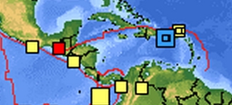
Magnitude
4.5
Date-Time
Sunday, December 18, 2011 at 05:03:19 UTC
Saturday, December 17, 2011 at 11:03:19 PM at epicenter
Time of Earthquake in other Time Zones
Location
15.832°N, 91.976°W
Depth
219.5 km (136.4 miles)
Region
CHIAPAS, MEXICO
Distances
49 km (30 miles) SSE of Comitan, Chiapas, Mexico
78 km (48 miles) NW of Huehuetenango, Guatemala
106 km (65 miles) NNE of Tapachula, Chiapas, Mexico
860 km (534 miles) ESE of MEXICO CITY, D.F., Mexico
Location Uncertainty
horizontal +/- 22 km (13.7 miles); depth +/- 10.9 km (6.8 miles)
Parameters
NST=173, Nph=176, Dmin=52.3 km, Rmss=1.07 sec, Gp=137°,
M-type=body wave magnitude (Mb), Version=9
Source
Magnitude: USGS NEIC (WDCS-D)
Location: USGS NEIC (WDCS-D)
Event ID
usc00077u9
earthquake.usgs.gov...
That "5.3" at the Kermadecs last night left a pretty big trace on LISS
SNZO
USGS 5.3mb
looks more like what the Russians have
RAS 5.6mb
4/36 usgs stations had over Mag 6
couple more mystery ones on the 9:00 line, Southern Ocean again?
USGS 5.3mb
looks more like what the Russians have
RAS 5.6mb
4/36 usgs stations had over Mag 6
edit on 19-12-2011 by muzzy because:
(no reason given)
couple more mystery ones on the 9:00 line, Southern Ocean again?
edit on 19-12-2011 by muzzy because: (no reason given)
Yo PM, just posted a new thread about a study that corroborates your findings that the earth's seismicity is not increasing:
www.abovetopsecret.com...
Pats on the back to you, Grumpy. So get glad!
www.abovetopsecret.com...
Pats on the back to you, Grumpy. So get glad!
Hi all!
How is every one?
Thought I would pop in and give you all a Christmas cookie to chew on.
Post-Glacial rebound.
Ever heard of it?
I didn't until an article a few weeks ago about Greenland gaining some more turf.
www.livescience.com...
Well,what the heck has that to do with the rest of the world,you ask.
en.wikipedia.org...
With the change in the earths crust due to the melting of the glaciers and ice sheets,I feel 2012 will possibly be quiet active as far as earthquakes are concerned.
What are your thoughts,grumpy.
How is every one?
Thought I would pop in and give you all a Christmas cookie to chew on.
Post-Glacial rebound.
Ever heard of it?
I didn't until an article a few weeks ago about Greenland gaining some more turf.
The ice is melting so fast in Greenland that the giant island is rising noticeably as the weight is lifted. In some spots, the land is rising 1 inch per year. A vast ice cap covers much of Greenland, in some places up to 1.2 miles (2 km) thick. The ice, in place for eons, presses down the land, making the elevation at any given point lower than it would be sans ice. Scientists have documented on Greenland and elsewhere that when longstanding ice melts away, the land rebounds. Even the European Alps are rising as glaciers melt. Now, scientists at the University of Miami say Greenland's ice is melting so quickly that the land underneath is rising at an accelerated pace.
www.livescience.com...
Well,what the heck has that to do with the rest of the world,you ask.
Post-glacial rebound (or glacial isostatic adjustment) produces measurable effects on vertical crustal motion, global sea levels, horizontal crustal motion, gravity field, Earth's rotational motion and state of stress and earthquakes. Studies of glacial rebound give us information about the flow law of mantle rocks and also past ice sheet history. The former is important to the study of mantle convection, plate tectonics and the thermal evolution of the Earth. The latter is important to glaciology, paleoclimate and changes in global sea level. Understanding postglacial rebound is also important to our ability to monitor recent global change.
en.wikipedia.org...
With the change in the earths crust due to the melting of the glaciers and ice sheets,I feel 2012 will possibly be quiet active as far as earthquakes are concerned.
What are your thoughts,grumpy.
edit on 19-12-2011 by kdog1982 because: (no reason given)
UK as usual is having its version of a swarm, I expect it to settle in the next week and a bit!
2011/12/19 05:50:08.1 53.247 -0.438 6 1.4 LINCOLN,LINCOLSHIRE 6KM ENE OF LINCOLN
BGS
Oh and Kdog....studied post glacial rebound just over 30 years ago for what we call here in the UK 'A' levels...they be exams wot you gotta pass to get into 'igher schools of learning....they taught me a lot more about it at said esteemed establishment too!......for all the good it did me! Must admit, glacial geology was one of my favourite subjects. Thank you for reminding me.
Hmmm...now you have me thinking about next years challenge....thank you!
Rainbows with mistletoe on!
Jane
Oh dear,
Magnitude mb 4.1
Region OFF COAST OF OREGON
Date time 2011-12-20 16:06:46.4 UTC
Location 44.15 N ; 128.71 W
Depth 10 km
Distances 447 km W Eugene (pop 145,208 ; local time 08:06:46.4 2011-12-20)
370 km W Coos bay (pop 15,394 ; local time 08:06:46.4 2011-12-20)
364 km W Bandon (pop 2,830 ; local time 08:06:46.4 2011-12-20)
www.emsc-csem.org...
Rainbows with mistletoes
Jane
reply to post by berkeleygal
Wonder what these quakes are all about.
Just when I thought Quitman had settled
down now we have all of these in one day
The fracking has stopped, right?
Wonder what these quakes are all about.
Just when I thought Quitman had settled
down now we have all of these in one day
The fracking has stopped, right?
reply to post by kdog1982
I first heard of post glacial rebound about 53 years ago in school. It has been around a long while!
www.cost-es0701.geoenvi.org...
The data does not agree but what the hell, global warming is causing Greenland to bob about on the ocean. We haven't got a clue, but the results of the study show that the science is not settled and we need more funding.
Grumpy thinks: Um, so what? We are in an interglacial period, or maybe going back into another ice age. Either way the climate is changing and it has JS to do with carbon dioxide.
Post glacial rebound in places is well in excess of 120 ft as far as I remember from my classroom days. A few friggin' millimetres on Greenland is nothing.
And just bear in mind that all this is done from computer models............
You can make them say what ever you want - bit like statistics!
2012? No apart from a possible 8 - 8.5 (50% chance) it will be quiet which is more than I can say about the economy of the world.
By the way, the UN states that people will drown because of rising sea levels. Really? How so? - at 3mm a year they will have to stay in one place for 533 years without budging for the water to come up over the head of the average man. Even at 25mm (1 inch) a year globally it would take 64 years. I really don't see how anyone can drown. Even a snail could move to higher ground in time. Just more warmunist BS I am afraid.
ETA: By the way the average temperature in the Arctic capitals is dropping
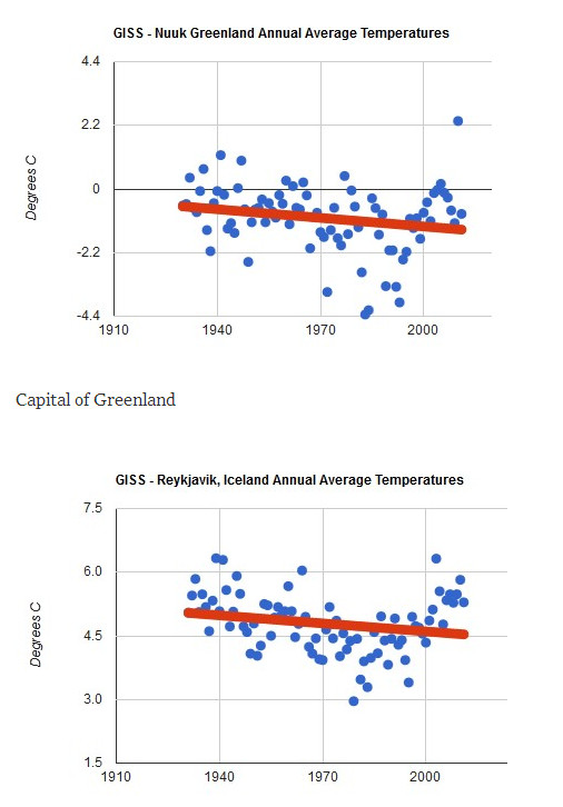
And on Svalbard I ready a study (for which i will find the link tomorrow) that anticipates a drop of 6°C over the next 20 years. Somehow i think the ice will not be melting so much.
Look up Summit Camp on Greenland. 'Her wot sits next to me' follows the temperature there daily. It is a refreshing -46° at present but was -50° earlier and 2 weeks ago was -60°
ETA: Link Solar activity and Svalbard temperatures
I first heard of post glacial rebound about 53 years ago in school. It has been around a long while!
Due to the fact that Greenland is still covered with ice, the number of uplift measurements
is very limited. This means that the ice loading history of the Greenland Ice Sheet is poorly
constrained. We show that present day uplift rate based on the two different ice histories
(ICE-5G and SICOPOLIS) give different patterns of present-day uplift rate. The difference in
the ice thickness (Figure 1) shows significantly different ice volume evolution starting from 9
ky BP. SICOPOLIS has thicker ice in some areas compared to ICE-5G from 8 ky BP until
present, this results in a larger present day rate of subsidence (see Table 2).
We find that the GIA signal from neither of the ice loading histories agrees with the GPS
derived uplift rate, which highlights the need for further studies in this region in order to
better constrain the ice loading histories as well as present and future sea level change is
this region.
www.cost-es0701.geoenvi.org...
The data does not agree but what the hell, global warming is causing Greenland to bob about on the ocean. We haven't got a clue, but the results of the study show that the science is not settled and we need more funding.
Grumpy thinks: Um, so what? We are in an interglacial period, or maybe going back into another ice age. Either way the climate is changing and it has JS to do with carbon dioxide.
Post glacial rebound in places is well in excess of 120 ft as far as I remember from my classroom days. A few friggin' millimetres on Greenland is nothing.
And just bear in mind that all this is done from computer models............
You can make them say what ever you want - bit like statistics!
2012? No apart from a possible 8 - 8.5 (50% chance) it will be quiet which is more than I can say about the economy of the world.
By the way, the UN states that people will drown because of rising sea levels. Really? How so? - at 3mm a year they will have to stay in one place for 533 years without budging for the water to come up over the head of the average man. Even at 25mm (1 inch) a year globally it would take 64 years. I really don't see how anyone can drown. Even a snail could move to higher ground in time. Just more warmunist BS I am afraid.
edit on 20/12/2011 by PuterMan because: (no reason given)
ETA: By the way the average temperature in the Arctic capitals is dropping
And on Svalbard I ready a study (for which i will find the link tomorrow) that anticipates a drop of 6°C over the next 20 years. Somehow i think the ice will not be melting so much.
Look up Summit Camp on Greenland. 'Her wot sits next to me' follows the temperature there daily. It is a refreshing -46° at present but was -50° earlier and 2 weeks ago was -60°
edit on 20/12/2011 by PuterMan because: (no reason given)
ETA: Link Solar activity and Svalbard temperatures
edit on 20/12/2011 by PuterMan because: (no reason given)
53 years years ago,huh.
Wow,you are almost older than dirt and a much better educational system then here in the states.
Or was that college?
And,I won't call you grumpy any more,just a crabbit,if that is the correct term.
Wow,you are almost older than dirt and a much better educational system then here in the states.
Or was that college?
And,I won't call you grumpy any more,just a crabbit,if that is the correct term.
reply to post by PuterMan
I tend to agree, the main concern is storm surge, that island in the Pacific (whose name escapes me but it starts with Tua... and their LISS graph is always a mess) that is only a few metres above sea level and they are history. I've read a few reports that its the island thats sinking, not the sea level rising, as happens with volcanic islands from time to time ( they don't just come up out of the sea like Hierro in the Canaries did.)
I know you don't watch TV much, but I seen a doco last week about The Mini-Ice Age 1500-1800something, The Dark Ages, Black Death, Irish Potato Famine etc etc people starved for 300 years due to a downturn in the temperature and bad weather (failed crops). It ended when Tambora erupted and after 18 months it was all over and since then we have been in a Warm Period, like back in the period prior to 1500. Well worth a watch if you can catch it.
reply to post by muzzy
Hey muzzy,that is what I watched,the little ice age,which kind of led me to the path of the glaciers melting and land rising and such.
Hey muzzy,that is what I watched,the little ice age,which kind of led me to the path of the glaciers melting and land rising and such.
UK continues its little swarm
2011/12/21 06:40:53.0 56.252 -3.750 7 1.6 BLACKFORD,PERTH/KINROSS
www.earthquakes.bgs.ac.uk...
rainbows with tinsel
Jane
2011/12/21 06:40:53.0 56.252 -3.750 7 1.6 BLACKFORD,PERTH/KINROSS
www.earthquakes.bgs.ac.uk...
rainbows with tinsel
Jane
reply to post by kdog1982
Which actually is the same thing as crabbit is just the Scots for grumpy or miserable!
Not college then, that was school - I was 10. I went on to do geography and geology A levels and back then they were the equivalent of a degree course. No 'coursework' marks - it was all by examination, hours and hours of it with no reference books allowed, and if you did not know it you failed! Modern youngsters could not stand that. No one fails these days.
Continental drift was in but 53 years ago it would be another 6 or so years before plate tectonics raised it's head while I was a senior school, high school or whatever you would call it. Actually it was Public School, which as you may not be aware is actually the best type of private school in England.
I still find plate tectonics a problem after all this time. Something is not quite right with it but that is another story.
Ah dornt pure mid if ye caa me crabbit since Ah probably am. it's mah age ye ken.
reply to post by muzzy
Hasn't been turn on once in over 2 years or more now.
Here you are, from the Tuvalu web site
Little Evidence To Show Pacific Ocean Rising Due To Global Warming: Scientist
And here is another from Tuvalu
Tuvalu's tides divide scientists:August 25, 2004
A bit later than the first one but still the uncertainty remains.
So it is a mixture of the geology, the volcanism et al and oceanography and as the article says, we don't actually have the answers yet regardless of what Patchuri's Pension Fund says.
And,I won't call you grumpy any more,just a crabbit,if that is the correct term.
Which actually is the same thing as crabbit is just the Scots for grumpy or miserable!
Not college then, that was school - I was 10. I went on to do geography and geology A levels and back then they were the equivalent of a degree course. No 'coursework' marks - it was all by examination, hours and hours of it with no reference books allowed, and if you did not know it you failed! Modern youngsters could not stand that. No one fails these days.
Continental drift was in but 53 years ago it would be another 6 or so years before plate tectonics raised it's head while I was a senior school, high school or whatever you would call it. Actually it was Public School, which as you may not be aware is actually the best type of private school in England.
I still find plate tectonics a problem after all this time. Something is not quite right with it but that is another story.
Ah dornt pure mid if ye caa me crabbit since Ah probably am. it's mah age ye ken.
reply to post by muzzy
I know you don't watch TV much
Hasn't been turn on once in over 2 years or more now.
Here you are, from the Tuvalu web site
Little Evidence To Show Pacific Ocean Rising Due To Global Warming: Scientist
The data, he said, are too little and too recent.
However, he said it was clear that relative sea level rises in places like Kiribati may have nothing to do with the global situation but rather with the way in which the local freshwater aquifers under each atoll are used.
If they are over used by the local population, atolls themselves can rise and fall, letting in more seawater to the fresh ground water and flooding garden pits, giving the effect of sea level rises.
"The land itself is not stable. It is moving and often it is moving because of local issues."
He said the early data suggested that the Pacific sea level might be rising by an average of two millimeters a year, but this is not uniform across the region and findings often are based on data less than 10 years old.
In Kiribati, the data show the sea level fell by 21 millimeters while, just to the north, the Marshalls show it rose 2.9 millimeters.
"We are not finding places where the sea level rise is very strong," Scherer said.
And here is another from Tuvalu
Tuvalu's tides divide scientists:August 25, 2004
A bit later than the first one but still the uncertainty remains.
It sounds like an open-and-shut case. Cut emissions and global warming will stop. Sea levels will stabilise. Tuvalu will be saved. The science behind such conclusions reveals, however, that it is not that simple.
Firstly, global warming is not the only factor affecting sea levels in the Pacific.
Bill Mitchell, the manager of the National Tidal Facility in Adelaide, which is collecting data in the region, says the ebb and flow of the sea is not fully understood.
"It's very, very complex. You have to get a handle on the movement of land. There are changes in weather, barometric pressure and oceanographic processes such as currents."
Those oceanographic processes include the Pacific Decadal Oscillation, where a huge slosh of water moves around the ocean over a 10-year cycle.
The El Nino effect has also played a part. Interruptions to trade winds across the ocean have affected global weather patterns, making the sea rise and fall unexpectedly.
"The IPCC has done its best, considering the thousands of scientists who have contributed," says Mitchell, "but the truth is that scientists don't really know if they've got a handle on it."
So it is a mixture of the geology, the volcanism et al and oceanography and as the article says, we don't actually have the answers yet regardless of what Patchuri's Pension Fund says.
edit on 21/12/2011 by PuterMan because: (no reason given)
edit on 21/12/2011 by PuterMan because: (no reason given)
Originally posted by PuterMan
reply to post by kdog1982
And,I won't call you grumpy any more,just a crabbit,if that is the correct term.
Which actually is the same thing as crabbit is just the Scots for grumpy or miserable!
Not college then, that was school - I was 10. I went on to do geography and geology A levels and back then they were the equivalent of a degree course. No 'coursework' marks - it was all by examination, hours and hours of it with no reference books allowed, and if you did not know it you failed! Modern youngsters could not stand that. No one fails these days.
Ah dornt pure mid if ye caa me crabbit since Ah probably am. it's mah age ye ken.
Yep...In those days A levels were tougher than getting your degree! Mind you allowed more time for Uni students to get on with what they do best!
"Ye ken"....Aberdonian twang there PM??!!
Rainbows with mistletoe
Jane
Magnitude 5.7
Date-Time
Wednesday, December 21, 2011 at 13:37:18 UTC
Thursday, December 22, 2011 at 01:37:18 AM at epicenter
Location 33.127°S, 178.895°W
Depth 27.6 km (17.2 miles)
Region SOUTH OF THE KERMADEC ISLANDS
Distances 188 km (116 miles) S of L'Esperance Rock, Kermadec Islands
438 km (272 miles) SSW of Raoul Island, Kermadec Islands
711 km (441 miles) NE of Auckland, New Zealand
1065 km (661 miles) NNE of WELLINGTON, New Zealand
Location Uncertainty horizontal +/- 16.1 km (10.0 miles); depth +/- 7.5 km (4.7 miles)
Parameters NST=157, Nph=162, Dmin=440.8 km, Rmss=0.94 sec, Gp= 29°,
M-type=regional moment magnitude (Mw), Version=6
Source
Magnitude: USGS NEIC (WDCS-D)
Location: USGS NEIC (WDCS-D)
Event ID usc00079sb
earthquake.usgs.gov...
5.7mb, 5.7ML, 5.7Mw
Also a odd one from GFZ
geofon.gfz-potsdam.de...
F-E Region: North Pacific Ocean
Time: 2011-12-21 13:45:02.8 UTC
Magnitude: 5.8
Epicenter: 169.75°E 38.55°N
Depth: 10 km
Status: A - automatic
GM location map
could be an error
new topics
-
Thousands Of Young Ukrainian Men Trying To Flee The Country To Avoid Conscription And The War
Other Current Events: 1 hours ago -
12 jurors selected in Trump criminal trial
US Political Madness: 4 hours ago -
Iran launches Retalliation Strike 4.18.24
World War Three: 4 hours ago -
Israeli Missile Strikes in Iran, Explosions in Syria + Iraq
World War Three: 5 hours ago -
George Knapp AMA on DI
Area 51 and other Facilities: 10 hours ago -
Not Aliens but a Nazi Occult Inspired and then Science Rendered Design.
Aliens and UFOs: 11 hours ago
top topics
-
George Knapp AMA on DI
Area 51 and other Facilities: 10 hours ago, 25 flags -
Israeli Missile Strikes in Iran, Explosions in Syria + Iraq
World War Three: 5 hours ago, 14 flags -
Louisiana Lawmakers Seek to Limit Public Access to Government Records
Political Issues: 13 hours ago, 7 flags -
So I saw about 30 UFOs in formation last night.
Aliens and UFOs: 16 hours ago, 6 flags -
Iran launches Retalliation Strike 4.18.24
World War Three: 4 hours ago, 6 flags -
Do we live in a simulation similar to The Matrix 1999?
ATS Skunk Works: 17 hours ago, 5 flags -
Not Aliens but a Nazi Occult Inspired and then Science Rendered Design.
Aliens and UFOs: 11 hours ago, 5 flags -
12 jurors selected in Trump criminal trial
US Political Madness: 4 hours ago, 4 flags -
The Tories may be wiped out after the Election - Serves them Right
Regional Politics: 14 hours ago, 3 flags -
Thousands Of Young Ukrainian Men Trying To Flee The Country To Avoid Conscription And The War
Other Current Events: 1 hours ago, 2 flags
active topics
-
Do we live in a simulation similar to The Matrix 1999?
ATS Skunk Works • 22 • : SchrodingersRat -
Iran launches Retalliation Strike 4.18.24
World War Three • 15 • : semperfortis -
Russia Ukraine Update Thread - part 3
World War Three • 5696 • : Kenzo -
President BIDEN Warned IRAN Not to Attack ISRAEL - Iran Responded with a Military Attack on Israel.
World War Three • 43 • : WeMustCare -
Israeli Missile Strikes in Iran, Explosions in Syria + Iraq
World War Three • 52 • : WeMustCare -
Mandela Effect - It Happened to Me!
The Gray Area • 107 • : inflaymes69 -
Terrifying Encounters With The Black Eyed Kids
Paranormal Studies • 45 • : daskakik -
Not Aliens but a Nazi Occult Inspired and then Science Rendered Design.
Aliens and UFOs • 12 • : BeyondKnowledge3 -
Elites disapearing
Political Conspiracies • 31 • : Degradation33 -
MULTIPLE SKYMASTER MESSAGES GOING OUT
World War Three • 47 • : SchrodingersRat