It looks like you're using an Ad Blocker.
Please white-list or disable AboveTopSecret.com in your ad-blocking tool.
Thank you.
Some features of ATS will be disabled while you continue to use an ad-blocker.

Quake Watch 2011
page: 379share:
reply to post by crazydaisy
luckily they are where they are, on land it would be a bit disconcerting
I'm working on a decent map, have to make some new icons with fs on them to show "foreshock" otherwise its just a jumble
like this
current events

just a kitten compared to
map of the 1995 swarm Feb 5 to Dec 31
4261 aftershocks from a 6.991 ML mainshock (the depth of those averaged 12km, a bit shallower than the current one)

luckily they are where they are, on land it would be a bit disconcerting
I'm working on a decent map, have to make some new icons with fs on them to show "foreshock" otherwise its just a jumble
like this
current events
just a kitten compared to
map of the 1995 swarm Feb 5 to Dec 31
4261 aftershocks from a 6.991 ML mainshock (the depth of those averaged 12km, a bit shallower than the current one)
edit on 18-11-2011 by muzzy because: (no reason given)
reply to post by muzzy
Last 7 days - all NZ kmz for Google earth
I am sure you can do much better muzzy but since I looked at it I thought I may as well post it.
Last 7 days - all NZ kmz for Google earth
I am sure you can do much better muzzy but since I looked at it I thought I may as well post it.
Heres my version/s
interactive map all NZ 18112011 ( icons unmarked except those with F for Felt (felt reports inside F icon tags)
and the Last 7 Days version is linked in my signature
interactivemap os East Cape (some marked with f for Foreshock, and 0 for Aftershock, but no felt reports inside)
I wasn't sure where this series was going, so I started the icons at 0 as "Day of Event" aftershocks
Hasn't been much since, looks like just a couple of 3's in the last 12 hours
A strange one indeed
might as well throw this one in as well, buy 3 get one free
Mag5+ All NZ 2011
Fiordland has been quiet this year
edit: I'll probably edit that KMZ file for os East Cape at the end of the day, hopefully it will update on this page too.
interactive map all NZ 18112011 ( icons unmarked except those with F for Felt (felt reports inside F icon tags)
and the Last 7 Days version is linked in my signature
interactivemap os East Cape (some marked with f for Foreshock, and 0 for Aftershock, but no felt reports inside)
I wasn't sure where this series was going, so I started the icons at 0 as "Day of Event" aftershocks
Hasn't been much since, looks like just a couple of 3's in the last 12 hours
A strange one indeed
edit on 19-11-2011 by muzzy because: (no reason given)
might as well throw this one in as well, buy 3 get one free
Mag5+ All NZ 2011
Fiordland has been quiet this year
edit: I'll probably edit that KMZ file for os East Cape at the end of the day, hopefully it will update on this page too.
edit on
19-11-2011 by muzzy because: (no reason given)
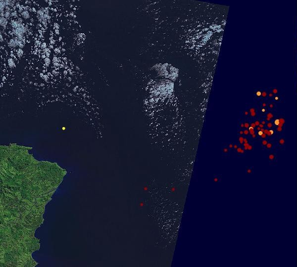
On one side of the Pacific, we have:
While on the other side, we have:
Magnitude 5.1
Date-Time Saturday, November 19, 2011 at 19:27:34 UTC Sunday,November 20,2011at 04:27:34AM at epicenter Time of Earthquakein otherTimeZones
Location 35.384°N, 140.697°E
Depth 6 km (3.7 miles)
Region NEAR THE EAST COAST OF HONSHU, JAPAN
Distances 92 km (57 miles) ESE of TOKYO, Japan 97 km (60 miles) E of Yokohama, Honshu, Japan 111 km (68 miles) S of Mito, Honshu, Japan 149 km (92 miles) SSE of Utsunomiya, Honshu, Japan
Location Uncertainty horizontal+/- 11.9 km (7.4miles);depth +/- 5.3km (3.3miles)
Parameters NST=197, Nph=204, Dmin=259.4 km, Rmss=0.86 sec, Gp= 90°, M-type=body wave magnitude (Mb), Version=6
Source Magnitude: USGSNEIC (WDCS-D) Location: USGSNEIC (WDCS-D)
Event ID usc0006uxz
While on the other side, we have:
Magnitude 5.1
Date-Time Saturday, November 19, 2011 at 19:02:32 UTC Saturday,November 19,2011at 12:02:32PM at epicenter Time of Earthquakein otherTimeZones
Location 4.614°S, 105.049°W
Depth 10.8 km (6.7 miles)
Region CENTRAL EAST PACIFIC RISE
Distances 1612 km (1001 miles) WSW of Puerto Villamil, Isabela, Galapagos 1715 km (1065 miles) SSE of Clipperton Island 2663 km (1654 miles) SW of GUATEMALA, Guatemala 2808 km (1744 miles) W of Guayaquil, Ecuador
Location Uncertainty horizontal+/- 24.1 km (15.0 miles);depth +/- 6.1km (3.8miles)
Parameters NST=250, Nph=255, Dmin=>999 km, Rmss=0.84 sec, Gp=144°, M-type=body wave magnitude (Mb), Version=6
Source Magnitude: USGSNEIC (WDCS-D) Location: USGSNEIC (WDCS-D)
Event ID usc0006uxe
reply to post by jadedANDcynical
Very Shallow
Magnitude 5.1mb
Depth 6 km (3.7 miles)
Region NEAR THE EAST COAST OF HONSHU, JAPAN
Distances 92 km (57 miles) ESE of TOKYO, Japan 97 km (60 miles) E of Yokohama, Honshu, Japan 111 km (68 miles) S of Mito, Honshu, Japan 149 km (92 miles) SSE of Utsunomiya, Honshu, Japan
Event ID usc0006uxz
must have been this one 4.8ML on JMA
that East Pacific Rise is more "in the middle" than "on the other side" IMO, when I seen the first line of your post , without scrollong down yet, I thought the "other side" was going to be Andreanof Is
I see the Andreanof Is. one is a 5.7 Mw on Geofon, and it has been manually reviewed
USGS have 5.1mb
big difference
there seems to be some kind of policy at USGS not to convert certain earthquakes to Mw
edit on 19-11-2011 by muzzy because: (no reason
given)
Originally posted by muzzy
Hasn't been much since, looks like just a couple of 3's in the last 12 hours
being a Sunday here I have time to follow this quite closely, those last two bigger ones are low Mag 4's, the other tiny ones are 3's.
IRIS URZ HHZ isn't showing much either, according to Geonet there have been 10 more aftershocks since midnight os East Cape
UTC - MAG
00:08:31 - 3.454
00:52:03 - 4.178
00:58:01 - 3.69
04:33:31 - 3.904
05:46:15 - 3.232
08:33:56 - 4.186
09:04:17 - 3.328
11:54:23 - 3.045
13:20:11 - 3.386
14:48:03 - 3.249
From the Land of the Rising Sun:
Are things picking up again over there?
Magnitude 5.2
Date-Time Sunday, November 20, 2011 at 01:23:43 UTC Sunday,November 20,2011at 10:23:43AM at epicenter Time of Earthquakein otherTimeZones
Location 36.768°N, 140.449°E
Depth 24.7 km (15.3 miles)
Region NEAR THE EAST COAST OF HONSHU,JAPAN
Distances 44 km (27 miles) N of Mito, Honshu, Japan 49 km (30 miles) SW of Iwaki, Honshu, Japan 56 km (34 miles) ENE of Utsunomiya, Honshu, Japan 136 km (84 miles) NNE of TOKYO, Japan
Location Uncertainty horizontal+/- 15.5 km (9.6miles);depth +/- 7.4km (4.6miles)
Parameters NST=291, Nph=291, Dmin=202.6 km, Rmss=0.7 sec, Gp= 97°, M-type=body wave magnitude (Mb), Version=A
Source Magnitude: USGSNEIC (WDCS-D) Location: USGSNEIC (WDCS-D)
Event ID usc0006v1y
Are things picking up again over there?
reply to post by jadedANDcynical
the magnitudes seem to be getting slightly higher, if you watch this page on JMA
note they are also all land based, so not necessarily aftershocks of the March 11 Mag 9.1
I'm getting to the point where USGS is just used as a reference point, they are so out of sync. with the local networks when it comes to magnitudes I just don't believe a word of it any more ,
that first one JMA was 4.8ML and USGS had 5.1 (up 3 points)
this latest one was JMA 5.5ML and USGS has 5.2 (down 3 points )
how can that be
heres the JMA page for that quake
basically when it come to Japan the only use I have for USGS is to see what the local time was so I can find it on the JMA list (JST)
Originally posted by jadedANDcynical
From the Land of the Rising Sun:
(snippy snip)
Are things picking up again over there?
Lord, I sincerely hope not.
Every time I see increased activity in Japan these days, especially along Honshu's eastern coastal region, I think about those destroyed/melted/trashed reactors and spent fuel pools at Fukushima Dai-chi. No matter what they do there to try and stabilize and contain the situation, just one larger quake or (heaven forbid!) tsunami could make matters far worse than they already are.
The problem is, that will be the case for many years hence.
MAP 4.8 2011/11/20 10:23:45 59.245 -30.456 10.0 REYKJANES RIDGE
MAP 3.1 2011/11/20 09:48:37 60.884 -152.920 160.3 SOUTHERN ALASKA
MAP 4.8 2011/11/20 09:28:38 59.293 -30.546 9.9 REYKJANES RIDGE
MAP 3.0 2011/11/20 09:27:06 18.727 -66.877 91.0 PUERTO RICO REGION
MAP 2.7 2011/11/20 09:26:15 18.564 -65.029 22.0 VIRGIN ISLANDS REGION
MAP 4.9 2011/11/20 09:19:22 59.418 -30.201 10.0 REYKJANES RIDGE
source(usgs.gov/earthqearthquake.uakes/recenteqsww/Quakes/quakes_all.html
Hmmm.....
Originally posted by diamondsmith
MAP 4.8 2011/11/20 10:23:45 59.245 -30.456 10.0 REYKJANES RIDGE
MAP 4.8 2011/11/20 09:28:38 59.293 -30.546 9.9 REYKJANES RIDGE * match
MAP 4.9 2011/11/20 09:19:22 59.418 -30.201 10.0 REYKJANES RIDGE *match
source(usgs.gov/earthqearthquake.uakes/recenteqsww/Quakes/quakes_all.html
Hmmm.....
USGS missed one and Geofon missed another
2011-11-20 09:28:51 4.5 59.38°N 28.55°W 10 A Reykjanes Ridge
2011-11-20 09:27:33 4.2 59.69°N 29.54°W 10 C Reykjanes Ridge *match
2011-11-20 09:19:24 5.0 59.38°N 30.10°W 10 C Reykjanes Ridge *match
geofon.gfz-potsdam.de...
reply to post by muzzy
Because USGS use Mb, Mw, Mi. Mblg, Abc, Xyz, Ms, Gs, and mainly Bs whereas JMO only use ML.
Since USGS never uses ML they are never going to sing from the same hymn sheet!
How can that be?
Because USGS use Mb, Mw, Mi. Mblg, Abc, Xyz, Ms, Gs, and mainly Bs whereas JMO only use ML.
Since USGS never uses ML they are never going to sing from the same hymn sheet!
15 minutes to end of 20-11-2011
will do an update of os East Cape NZ soon
biggest one this morning was;
Mag, Ref, Lat, Long, UTC, Depth
4.801, 3613938, -37.36843, 179.86632, 2011/11/20 15:53:26, 2
shallow
I'm not sure what the measurements from are when they are under the sea
at that location the sea is already 3.5km deep to start with
is the eq depth from the sea bed?
reply to post by PuterMan
anyone who still speaks in yards and 1/32ths cain't be trusted anyway
edit on 20-11-2011 by muzzy because: (no reason given)
reply to post by muzzy
According to the people who speak in yards, feet and fractions of an inch and still use that quaint F scale for temperature......
From the Glossary of terms
I'm not sure what the measurements from are when they are under the sea
at that location the sea is already 3.5km deep to start with
is the eq depth from the sea bed?
According to the people who speak in yards, feet and fractions of an inch and still use that quaint F scale for temperature......
The depth where the earthquake begins to rupture. This depth may be relative to mean sea-level or the average elevation of the seismic stations which provided arrival-time data for the earthquake location. The choice of reference depth is dependent on the method used to locate the earthquake. Sometimes when depth is poorly constrained by available seismic data, the location program will set the depth at a fixed value. For example, 33 km is often used as a default depth for earthquakes determined to be shallow, but whose depth is not satisfactorily determined by the data, whereas default depths of 5 or 10 km are often used in mid-continental areas and on mid-ocean ridges since earthquakes in these areas are usually shallower than 33 km.
From the Glossary of terms
edit on 20/11/2011 by PuterMan because: (no reason given)
I just came across this while I was looking for something else.
How Are Earthquakes Related to Plate Tectonics?
Some might enjoy it. It is an easy to understand and graphically informative look at earthquakes.
If you click on 'Investigations' when you have finished you will find a raft of other 'stuff' as well.
ETA: Just found another excellent one
www.ussartf.org...
How Are Earthquakes Related to Plate Tectonics?
Some might enjoy it. It is an easy to understand and graphically informative look at earthquakes.
If you click on 'Investigations' when you have finished you will find a raft of other 'stuff' as well.
edit on 20/11/2011 by PuterMan because: (no reason given)
ETA: Just found another excellent one
www.ussartf.org...
edit on 20/11/2011 by PuterMan because: (no reason given)
Thanks for the links, Puterman.
What is the significance of earthquakes along Reykjanes Ridge? We don't get quakes here in Newfoundland but this is the closest I've seen them to the island. Though I do remember seeing them numerous times in the past in the same sort of 2-3 4.5+ quakes surge. Is it common for that area to release a bit of pressure every couple of weeks?
What is the significance of earthquakes along Reykjanes Ridge? We don't get quakes here in Newfoundland but this is the closest I've seen them to the island. Though I do remember seeing them numerous times in the past in the same sort of 2-3 4.5+ quakes surge. Is it common for that area to release a bit of pressure every couple of weeks?
reply to post by murkraz
Yes it is the time of year for Reykjanes earthquakes. Mostly, but not always there is a burst of quakes that starts around the beginning of the hurricanes season and extends through until around January. I can vary though with some bunches in summer some years. I have not looked yet to see if those years are also bad weather summers.
What is the significance of earthquakes along Reykjanes Ridge? We don't get quakes here in Newfoundland but this is the closest I've seen them to the island. Though I do remember seeing them numerous times in the past in the same sort of 2-3 4.5+ quakes surge. Is it common for that area to release a bit of pressure every couple of weeks?
Yes it is the time of year for Reykjanes earthquakes. Mostly, but not always there is a burst of quakes that starts around the beginning of the hurricanes season and extends through until around January. I can vary though with some bunches in summer some years. I have not looked yet to see if those years are also bad weather summers.
Magnitude
5.9
Date-Time
Monday, November 21, 2011 at 03:15:43 UTC
Monday, November 21, 2011 at 09:45:43 AM at epicenter
Time of Earthquake in other Time Zones
Location
24.947°N, 95.226°E
Depth
121 km (75.2 miles)
Region
MYANMAR,source(earthquake.usgs.gov...
Is this isolated one?
5.9
Date-Time
Monday, November 21, 2011 at 03:15:43 UTC
Monday, November 21, 2011 at 09:45:43 AM at epicenter
Time of Earthquake in other Time Zones
Location
24.947°N, 95.226°E
Depth
121 km (75.2 miles)
Region
MYANMAR,source(earthquake.usgs.gov...
Is this isolated one?
reply to post by murkraz
While Newfoundland is not known for quakes, it has had a few biggies in the general region, including a subsea magnitude 7.2 on November 18, 1929 that produced a localized tsunami.
You can read about it in this Earthquakes Canada article entitled The 1929 Magnitude 7.2 "Grand Banks" earthquake and tsunami. A very good article, that includes photographs, maps, and many details of the mechanics of the tsunami. Well worth reading.
Mike
edit on 21/11/11 by JustMike because: typos
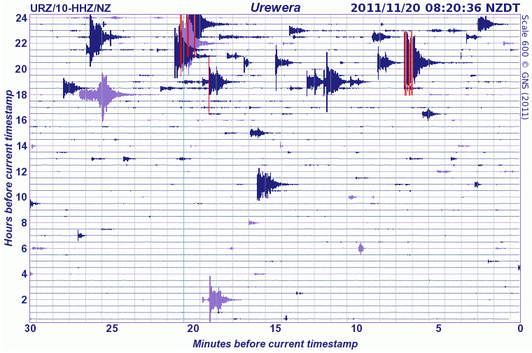
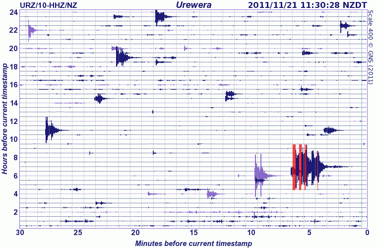
Update on os East Cape NZ
same Interactive Map as before, 5 x Day 2 aftershocks added
just the one quake identified since I did this last night, a 4.227
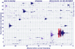
URZ Geonet Graph
seem to be staying in the same general area, on (under) the overlapping East Cape Ridge (Australian Plate)
same Interactive Map as before, 5 x Day 2 aftershocks added
just the one quake identified since I did this last night, a 4.227
URZ Geonet Graph
seem to be staying in the same general area, on (under) the overlapping East Cape Ridge (Australian Plate)
new topics
-
whistleblower Captain Bill Uhouse on the Kingman UFO recovery
Aliens and UFOs: 2 hours ago -
1980s Arcade
General Chit Chat: 5 hours ago -
Deadpool and Wolverine
Movies: 5 hours ago -
Teenager makes chess history becoming the youngest challenger for the world championship crown
Other Current Events: 6 hours ago -
CIA botched its handling of sexual assault allegations, House intel report says
Breaking Alternative News: 7 hours ago -
Lawsuit Seeks to ‘Ban the Jab’ in Florida
Diseases and Pandemics: 10 hours ago
top topics
-
Lawsuit Seeks to ‘Ban the Jab’ in Florida
Diseases and Pandemics: 10 hours ago, 20 flags -
Starburst galaxy M82 - Webb Vs Hubble
Space Exploration: 12 hours ago, 11 flags -
CIA botched its handling of sexual assault allegations, House intel report says
Breaking Alternative News: 7 hours ago, 8 flags -
The Superstition of Full Moons Filling Hospitals Turns Out To Be True!
Medical Issues & Conspiracies: 14 hours ago, 8 flags -
IDF Intel Chief Resigns Over Hamas attack
Middle East Issues: 17 hours ago, 6 flags -
whistleblower Captain Bill Uhouse on the Kingman UFO recovery
Aliens and UFOs: 2 hours ago, 6 flags -
15 Unhealthiest Sodas On The Market
Health & Wellness: 12 hours ago, 5 flags -
Teenager makes chess history becoming the youngest challenger for the world championship crown
Other Current Events: 6 hours ago, 3 flags -
Deadpool and Wolverine
Movies: 5 hours ago, 3 flags -
1980s Arcade
General Chit Chat: 5 hours ago, 3 flags
active topics
-
New whistleblower Jason Sands speaks on Twitter Spaces last night.
Aliens and UFOs • 39 • : RookQueen2 -
23,000 Dead People Registered Within a Two Week Period In One State
US Political Madness • 39 • : Audreagassulke -
How ageing is" immune deficiency"
Medical Issues & Conspiracies • 25 • : Kenzo -
1980s Arcade
General Chit Chat • 7 • : Freeborn -
Europe declares war on Russia?
World War Three • 59 • : Freeborn -
George Knapp AMA on DI
Area 51 and other Facilities • 38 • : theshadowknows -
Candidate TRUMP Now Has Crazy Judge JUAN MERCHAN After Him - The Stormy Daniels Hush-Money Case.
Political Conspiracies • 618 • : WeMustCare -
-@TH3WH17ERABB17- -Q- ---TIME TO SHOW THE WORLD--- -Part- --44--
Dissecting Disinformation • 605 • : Ektar -
Teenager makes chess history becoming the youngest challenger for the world championship crown
Other Current Events • 3 • : Skinnerbot -
So you don't believe in the devil
Paranormal Studies • 143 • : burritocat