It looks like you're using an Ad Blocker.
Please white-list or disable AboveTopSecret.com in your ad-blocking tool.
Thank you.
Some features of ATS will be disabled while you continue to use an ad-blocker.

Quake Watch 2011
page: 347share:
reply to post by Vitchilo
Ummmm....sure. Maybe this is why the recent report that experts expect another one 'soon'???
Ummmm....sure. Maybe this is why the recent report that experts expect another one 'soon'???
reply to post by westcoast
That blue one at the end is odd. I can't quite make out what it is. It sounds something like a quake but it is a bit fuzzy. There is no clear P and S
I am wondering if it could be a rock fall perhaps.
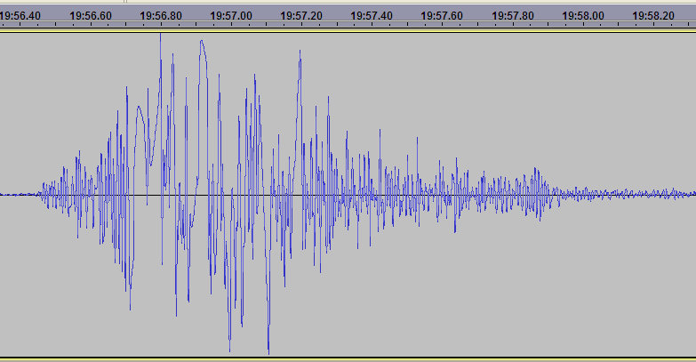
Addendum:
Now I see where this seismo is it obviously cannot be tree roots sounds. I would imagine, although i don't know, that ice cracks would sound similar. We all (well most) know what ice on a pond sounds like. Could this be ice in view of the fact that there a dozen or more glaciers, and it is getting colder? Katla and the other Icelandic do this regularly. (Have small ice induced earthquakes)
That blue one at the end is odd. I can't quite make out what it is. It sounds something like a quake but it is a bit fuzzy. There is no clear P and S
I am wondering if it could be a rock fall perhaps.
Addendum:
Now I see where this seismo is it obviously cannot be tree roots sounds. I would imagine, although i don't know, that ice cracks would sound similar. We all (well most) know what ice on a pond sounds like. Could this be ice in view of the fact that there a dozen or more glaciers, and it is getting colder? Katla and the other Icelandic do this regularly. (Have small ice induced earthquakes)
edit on 1/11/2011 by PuterMan because: (no reason given)
reply to post by westcoast
I hereby declare that I take back anything nice I ever said about scientists.
No doubt they will add some lubricant as well. So let me see drilling Japan, drilling Campi Flegri, anywhere else?
Let's just drill holes everywhere and ventilate the planet.
I hereby declare that I take back anything nice I ever said about scientists.
No doubt they will add some lubricant as well. So let me see drilling Japan, drilling Campi Flegri, anywhere else?
Let's just drill holes everywhere and ventilate the planet.
reply to post by JustMike
They do not calibrate every 18 hours. Calibration normally take place when the computer is restarted. These also appear at Yellowstone and the last time I asked I was told they were telemetry errors. Somewhere out there is a graphic showing these as telemetry errors but I can't find it. Not saying that is correct, just that there is one out there.
As I understand it calibration traces are spikes with long tail-offs, but I may be wrong. Note that all these are clipped whereas you can get very much larger seismic signals.
reply to post by PuterMan
This is what I'm trying to understand, so I'm glad for any feedback.
Well, something seems to be happening every 18 hours with that seismo. I suppose it was just unlucky that it was doing whatever-it-does just when that teleseismic should have arrived and been properly detected. What I can't figure out is exactly what would cause a telemetry glitch (if that's what it is) at such a regular interval.
Any ideers?
EDIT: perhaps "calibration" is the wrong term here, really. I'd originally thought that seismographs were calibrated at quite long intervals -- say annually or at the most every three months -- but I'd revised that based on what TA had said about calibration. Perhaps this is some kind of "test" signal but not actually a calibration?
Or perhaps I've got completely confused, which is always a distinct possibility.
EDIT 2: Hmmm... Just went digging and on this page at Pit and Quarry [dot] com, they say:
Of course, that is referring to calibration of the whole device (and it also might relate only to task-specific units used by mining companies. I don't know.) Not sure if what TA was referring to was something different.
Mike
This is what I'm trying to understand, so I'm glad for any feedback.
Well, something seems to be happening every 18 hours with that seismo. I suppose it was just unlucky that it was doing whatever-it-does just when that teleseismic should have arrived and been properly detected. What I can't figure out is exactly what would cause a telemetry glitch (if that's what it is) at such a regular interval.
Any ideers?
EDIT: perhaps "calibration" is the wrong term here, really. I'd originally thought that seismographs were calibrated at quite long intervals -- say annually or at the most every three months -- but I'd revised that based on what TA had said about calibration. Perhaps this is some kind of "test" signal but not actually a calibration?
Or perhaps I've got completely confused, which is always a distinct possibility.
EDIT 2: Hmmm... Just went digging and on this page at Pit and Quarry [dot] com, they say:
The recommended interval for calibration of most measuring equipment, including seismographs, is one year. Across most of North America and many parts of Europe, regulatory authorities actually require seismographs to be calibrated on an annual basis. This requirement has been, or is being adopted, by several other countries around the world and some specific projects even require that seismographs be calibrated every three or six months.
Of course, that is referring to calibration of the whole device (and it also might relate only to task-specific units used by mining companies. I don't know.) Not sure if what TA was referring to was something different.
Mike
edit on 1/11/11 by JustMike because: added edits.
reply to post by PuterMan
You crack me up!
Actually you do need a geologist, as that is not my area. I'm more enviro science. Geology is more of a hobby subject. I only did a couple of geo subjects but found myself arguing with the prof so thought I'd be better off studying this thread.
That was an excellent analysis of the Glacier Peak movements. Would you be able to put the sound file up somewhere so we can all have a chance to know what all these bumps sound like? thanks.
Originally posted by PuterMan
reply to post by MamaJ
You might like this perhaps
www.learninggeoscience.net...
Now THAT is what I'm talking about. This will be a great read and definitely be able to understand some of the specifics talked about here in this thread. Thanks a bunches!!!
As for digging in Japan....yeah, I can see where "it surely has to go into the sea" comes from. I mean...REALLY? How ignorant..not naive....ignorant. I don't know why I am surprised and I don't know why the residents there are not fleeing with their middle finger up in the air and pants down with the full moon on the rise. Just cannot believe it. (End of rant).
reply to post by zenius
I will put a file up but even at 20x speed it is over half an hour and I usually listen at 10x speed - so an hour of much nothing interspersed with pops.
If it is OK I will cut out the spaces to reduce the file.
By the way folks as yet another sign of approaching senility I labelled the 'monks gong' as MEGW. It is not of course it is GPW. MEGW was on the next line when I was looking for the title.
reply to post by JustMike
You are probably correct Mike and they are calibration. i was just going on what I was told once a long time ago and seeing as I am obviously going senile I am probably not remembering correctly!
edit on 1/11/2011 by PuterMan because: (no reason given)
reply to post by PuterMan
To me it looks like a landslide. I checked and found a page that has a similar looking signature.
www.teara.govt.nz...
To me it looks like a landslide. I checked and found a page that has a similar looking signature.
www.teara.govt.nz...
Hotspots along west ROF and around seem more active now
MAP 4.8 2011/11/01 22:41:59 -41.731 174.290 14.5 COOK STRAIT, NEW ZEALAND
MAP 5.0 2011/11/01 22:29:40 19.683 -109.266 9.9 REVILLA GIGEDO ISLANDS REGION
MAP 4.6 2011/11/01 22:28:47 -24.313 -67.246 204.6 SALTA, ARGENTINA
MAP 4.7 2011/11/01 22:02:14 2.551 97.151 45.9 NORTHERN SUMATRA, INDONESIA
MAP 4.3 2011/11/01 21:54:38 19.815 -109.333 10.0 REVILLA GIGEDO ISLANDS REGION
MAP 4.3 2011/11/01 21:10:45 38.881 43.581 5.0 EASTERN TURKEY
MAP 5.1 2011/11/01 17:58:34 -23.902 -69.173 79.2 ANTOFAGASTA, CHIL
reply to post by JustMike
Hi JustMike
I remembered reading about calibration pulses at the USGS site. Here is an excerpt:
The example shown doesn't look identical to the one PM was trying to decipher, but maybe different models of seismometers produce different looking pulses?
Source page
Hi JustMike
I remembered reading about calibration pulses at the USGS site. Here is an excerpt:
Once a day, the electronics in the seismometer sends a controlled current through the coil. The response of the magnet-spring-coil system to this test signal is sent back as a calibration pulse. These pulses can be measured at the central recording site in Menlo Park, California, to assure that each seismometer is functioning properly
The example shown doesn't look identical to the one PM was trying to decipher, but maybe different models of seismometers produce different looking pulses?
Source page
Anyone feel this??
Magnitude
4.8
Date-Time
Tuesday, November 01, 2011 at 22:41:58 UTC
Wednesday, November 02, 2011 at 11:41:58 AM at epicenter
Time of Earthquake in other Time Zones
Location
41.731°S, 174.290°E
Depth
14.5 km (9.0 miles)
Region
COOK STRAIT, NEW ZEALAND
Distances
65 km (40 miles) SW (219°) from WELLINGTON, New Zealand
190 km (118 miles) SW (215°) from Palmerston North, New Zealand
220 km (137 miles) E (90°) from Westport, New Zealand
Location Uncertainty
horizontal +/- 14.3 km (8.9 miles); depth +/- 9.6 km (6.0 miles)
Parameters
NST= 26, Nph= 26, Dmin=57.9 km, Rmss=1.19 sec, Gp=126°,
M-type=body wave magnitude (Mb), Version=5
Source
Magnitude: USGS NEIC (WDCS-D)
Location: USGS NEIC (WDCS-D)
Event ID
usb0006hux
earthquake.usgs.gov...
reply to post by ericblair4891
Thanks for that. So when I said it might be a rock fall that could well be right.
@Olivine: That calibration pulse is what I know of, and have seen regularly. Must try and find the other diagram.
Thanks for that. So when I said it might be a rock fall that could well be right.
@Olivine: That calibration pulse is what I know of, and have seen regularly. Must try and find the other diagram.
I'm in Vienna,relatively close to the epicenter. Didn't feel anything...
Magnitude M 4.2
Region HUNGARY
Date time 2011-11-01 23:56:34.0 UTC
Location 47.57 N ; 17.55 E
Depth 2 km
Distances 15 km SW Gyor (pop 129,009 ; local time 00:56:34.0 2011-11-02)
23 km E Csorna (pop 10,825 ; local time 00:56:34.0 2011-11-02)
2 km N Gyorszemere (pop 2,964 ; local time 00:56:34.0 2011-11-02)
reply to post by PuterMan
Hey Puterman, this isn't the clearest example, but I think it is what you were looking for.
Oops, I hit reply mid typing....
Anyway, I found this site describing how to remove the calibration pulse from the data, so as to see the seismic activity around it. Maybe helpful?
Hey Puterman, this isn't the clearest example, but I think it is what you were looking for.
Oops, I hit reply mid typing....
Anyway, I found this site describing how to remove the calibration pulse from the data, so as to see the seismic activity around it. Maybe helpful?
edit on 11/1/2011 by Olivine
because: (no reason given)
Originally posted by MamaJ
Anyone feel this??
Magnitude
4.8
Date-Time
Tuesday, November 01, 2011 at 22:41:58 UTC
Wednesday, November 02, 2011 at 11:41:58 AM at epicenter
Time of Earthquake in other Time Zones
Location
41.731°S, 174.290°E
Depth
14.5 km (9.0 miles)
Region
COOK STRAIT, NEW ZEALAND
Distances
65 km (40 miles) SW (219°) from WELLINGTON, New Zealand
190 km (118 miles) SW (215°) from Palmerston North, New Zealand
220 km (137 miles) E (90°) from Westport, New Zealand
Yep 733 people did, in the Upper South Island and Lower North Island, but I wasn't one of them
Don't know why, 1 other person in the suburb where I live reported in and all the suburbs around me too.
1.67%g PGA at Ward Fire Station nearest station, 0.06464%g at Kapiti island a few km from me, so lost most of its ooommffff by the time it got here.
www.geonet.org.nz...
SNZO BHI Graph , looks like an aftershock too
edit on 1-11-2011 by muzzy because: (no reason given)
Hungary joining in....
Magnitude M 4.2
Region HUNGARY
Date time 2011-11-01 23:56:32.0 UTC
Location 47.66 N ; 17.47 E
Depth 2 km
Distances 13 km W Gyor (pop 129,009 ; local time 00:56:32.7 2011-11-02)
17 km E Csorna (pop 10,825 ; local time 00:56:32.7 2011-11-02)
5 km NW Rábapatona (pop 2,497 ; local time 00:56:32.7 2011-11-02)
Source parameters not yet reviewed by a seismologist
EMSC
Rainbows
Jane
reply to post by zenius
This is proving somewhat difficult as the file is full of spikes (you can see them on the seismogram). These mean that I cannot lift the amplitude of the whole file because of the limits imposed by the program, and that means that you can hardly hear anything at all.
When I listen I identify a signal, slice it out so the clicks are not limiting, and amplify it.
I have tried removing the clicks but that leaves almost nothing and if i use a filter - same effect - virtually nothing audible left. This is always problem with a clicky file whether it is music or earthquakes.
So here it is, pretty much raw with as much done to it as i can in terms of volume. It is over 7mb unzipped and even zipped it is 4.2Mb so dial-up users take note.
UW_GPW _EHZ_20111101-000000_2000sps.zip
Would you be able to put the sound file up somewhere so we can all have a chance to know what all these bumps sound like?
This is proving somewhat difficult as the file is full of spikes (you can see them on the seismogram). These mean that I cannot lift the amplitude of the whole file because of the limits imposed by the program, and that means that you can hardly hear anything at all.
When I listen I identify a signal, slice it out so the clicks are not limiting, and amplify it.
I have tried removing the clicks but that leaves almost nothing and if i use a filter - same effect - virtually nothing audible left. This is always problem with a clicky file whether it is music or earthquakes.
So here it is, pretty much raw with as much done to it as i can in terms of volume. It is over 7mb unzipped and even zipped it is 4.2Mb so dial-up users take note.
UW_GPW _EHZ_20111101-000000_2000sps.zip
Originally posted by Vitchilo
To all of you experts :
Drilling Ship to Probe Fault Zone that Caused Fukushima Quake
After being tossed about and damaged by the tsunami that devastated northeastern Japan on March 11, Japan's drilling ship the Chikyu has been given an especially fitting assignment: to drill into the fault zone and take temperature measurements near the epicentre of the magnitude-9.0 Tohoku earthquake that caused the tsunami. It will be the first time that researchers have drilled into an underwater fault soon after a quake. The aim of the exercise is to solve a decades-old mystery about the part that friction plays in such an event. This should help scientists to understand why some faults are more likely than others to cause tsunamis — in this case, one that ultimately claimed more than 23,000 lives.
Couldn't this be dangerous??edit on 1-11-2011 by Vitchilo because: (no reason given)
Or maybe the TRUTH is that they're going to drill for samples, to verify they real cause of the Tsunami/quake...NUKES! ?
If the ship SINKS before completing its 'secret' missions, be very SUSPICIOUS, then come back and STAR me for the heads-up
new topics
-
Who guards the guards
US Political Madness: 1 hours ago -
Has Tesla manipulated data logs to cover up auto pilot crash?
Automotive Discussion: 3 hours ago -
whistleblower Captain Bill Uhouse on the Kingman UFO recovery
Aliens and UFOs: 8 hours ago -
1980s Arcade
General Chit Chat: 10 hours ago -
Deadpool and Wolverine
Movies: 11 hours ago
top topics
-
Lawsuit Seeks to ‘Ban the Jab’ in Florida
Diseases and Pandemics: 15 hours ago, 20 flags -
Starburst galaxy M82 - Webb Vs Hubble
Space Exploration: 17 hours ago, 13 flags -
CIA botched its handling of sexual assault allegations, House intel report says
Breaking Alternative News: 13 hours ago, 8 flags -
whistleblower Captain Bill Uhouse on the Kingman UFO recovery
Aliens and UFOs: 8 hours ago, 8 flags -
Deadpool and Wolverine
Movies: 11 hours ago, 4 flags -
1980s Arcade
General Chit Chat: 10 hours ago, 4 flags -
Teenager makes chess history becoming the youngest challenger for the world championship crown
Other Current Events: 12 hours ago, 3 flags -
Who guards the guards
US Political Madness: 1 hours ago, 1 flags -
Has Tesla manipulated data logs to cover up auto pilot crash?
Automotive Discussion: 3 hours ago, 0 flags
active topics
-
Another person lights themselves on fire and dies on College campus, happened in Red Deer, Canada
Mainstream News • 28 • : seekshelter -
Candidate TRUMP Now Has Crazy Judge JUAN MERCHAN After Him - The Stormy Daniels Hush-Money Case.
Political Conspiracies • 625 • : RazorV66 -
23,000 Dead People Registered Within a Two Week Period In One State
US Political Madness • 41 • : Xtrozero -
"We're All Hamas" Heard at Columbia University Protests
Social Issues and Civil Unrest • 202 • : network dude -
They Killed Dr. Who for Good
Rant • 64 • : Lazy88 -
Deadpool and Wolverine
Movies • 2 • : chiefsmom -
Has Tesla manipulated data logs to cover up auto pilot crash?
Automotive Discussion • 2 • : seekshelter -
Scientists Say Even Insects May Be Sentient
Science & Technology • 55 • : AdultMaleHumanUK -
-@TH3WH17ERABB17- -Q- ---TIME TO SHOW THE WORLD--- -Part- --44--
Dissecting Disinformation • 610 • : Justoneman -
Lawsuit Seeks to ‘Ban the Jab’ in Florida
Diseases and Pandemics • 24 • : VariedcodeSole