It looks like you're using an Ad Blocker.
Please white-list or disable AboveTopSecret.com in your ad-blocking tool.
Thank you.
Some features of ATS will be disabled while you continue to use an ad-blocker.

Quake Watch 2011
page: 314share:
reply to post by TXTriker
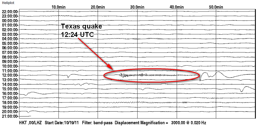
The 4.8 is not showing particularly clearly on that one. The BHZ channel of the same station is better: HKT.IU.00.BHZ.2011.293
This is the full plot from BUD Explorer for the LHZ channel whichas you see does not show as well: HKT.IU.00.LHZ.2011.293
By changing the sensitivity of the screen plot I am still not able to see the 'curvy' bits but I suspect these are being shown because of the filter they are using. I don't see any evidence of the 1800 (ish) event, even on the pumped up version: HKT.IU.00.LHZ.2011.293
I have marked the Texas quake
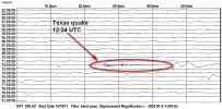
Now obviously there is going to be no time at all hardly between the event and the arrival at the HKT station, but what you would normally do for events further away is check the phase data on the USGS page for the event that you think it might be. From the Main page go to the Scientific & Technical tab and click the Phase Data link. On either the left or right hand side look for the station - HKT in this case - and look at the time of arrival.
Does this match the trace you are looking at? Yup! This exercise is explained in full here
The 4.8 is not showing particularly clearly on that one. The BHZ channel of the same station is better: HKT.IU.00.BHZ.2011.293
This is the full plot from BUD Explorer for the LHZ channel whichas you see does not show as well: HKT.IU.00.LHZ.2011.293
By changing the sensitivity of the screen plot I am still not able to see the 'curvy' bits but I suspect these are being shown because of the filter they are using. I don't see any evidence of the 1800 (ish) event, even on the pumped up version: HKT.IU.00.LHZ.2011.293
I have marked the Texas quake
Now obviously there is going to be no time at all hardly between the event and the arrival at the HKT station, but what you would normally do for events further away is check the phase data on the USGS page for the event that you think it might be. From the Main page go to the Scientific & Technical tab and click the Phase Data link. On either the left or right hand side look for the station - HKT in this case - and look at the time of arrival.
HKT ePn 12:25:19.42 0.1 2.3 60 g:8.8-1 1.0 4.2 HKT
Does this match the trace you are looking at? Yup! This exercise is explained in full here
edit on 20/10/2011 by PuterMan because: To correct spelling weirdness from the maestro of weird speeling eras.
Not a biggie, but worth noting I think:
Source: USGS
Mike
Magnitude 3.9 - SAN FRANCISCO BAY AREA, CALIFORNIA
2011 October 20 21:41:04 UTC
* Details
* Maps
* Scientific & Technical
* Tsunami
Earthquake Details
* This event has been reviewed by a seismologist.
Magnitude 3.9
Date-Time
* Thursday, October 20, 2011 at 21:41:04 UTC
* Thursday, October 20, 2011 at 02:41:04 PM at epicenter
Location 37.864°N, 122.249°W
Depth 9.8 km (6.1 miles)
Region SAN FRANCISCO BAY AREA, CALIFORNIA
Distances
* 2 km (2 miles) ESE (112°) from Berkeley, CA
* 5 km (3 miles) NE (47°) from Emeryville, CA
* 5 km (3 miles) NNW (341°) from Piedmont, CA
* 8 km (5 miles) NNW (346°) from Oakland, CA
Location Uncertainty horizontal +/- 0.2 km (0.1 miles); depth +/- 0.4 km (0.2 miles)
Parameters Nph= 90, Dmin=2 km, Rmss=0.18 sec, Gp= 22°,
M-type=regional moment magnitude (Mw), Version=5
Source
* California Integrated Seismic Net:
* USGS Caltech CGS UCB UCSD UNR
Event ID nc71667366
Source: USGS
Mike
edit on 20/10/11 by JustMike because: Added source linky.
Beta E of the program has just been released.
You can see the revisions on the Revisions page and can download the new version for any of the links on the Getting started with the QVS Data program page.
You must uninstall any previous version before installing this on. You databases should be OK in an uninstall as long as you use the Windows uninstaller and not Revo or ZSoft or similar. To be on the safe side you should back up the two .sdf files in the program folder (normally) C:\Program Files\DA Software\QVSData
reply to post by JustMike
The bay area eq was a strong jolt.. shook my whole house but it was just one jolt. Last months 3.5 was a few seconds longer.
The bay area eq was a strong jolt.. shook my whole house but it was just one jolt. Last months 3.5 was a few seconds longer.
May I pipe in?
I have been looking at this Texas quake,and there is a feature on there just south of where the quake was.
I was using google maps,then I switched to bing maps.
I will provide a link.
If you switch from aerial view to bird's eye view,it disappears.
www.bing.com...~-99.306923&qpvt=texas+maps&FORM=Z7FD1
Here it is in Google Earth.
What is it,a dried up pond??
edit on 20-10-2011 by kdog1982 because: (no reason given)
That quake was just 2 miles from me. Woke me up and scared the bejesuz outta me. What a way to wake up..
reply to post by berkeleygal
lol i'm near there too.. 5 miles away. Last month's 3.5 was about 4-7 seconds long... I watched my bookcase rattle... but this one felt like someone shook my whole house. Weird.
lol i'm near there too.. 5 miles away. Last month's 3.5 was about 4-7 seconds long... I watched my bookcase rattle... but this one felt like someone shook my whole house. Weird.
reply to post by kdog1982
Hi there,
no worries with joining in. Glad to have you on the thread! (This ain't an exclusive club.. yet! )
However, I'm not quite sure what feature you are asking about, because your Bing map link is for:
31.4367294311523 -99.3069229125977
whereas according to USGS the mag 4.8 quake** is located at:
28.806°N, 98.147°W
which is some way from your Bing reference.
** The quake was originally posted as a Mag 4.7 -- after review by a seismologist. Then they apparently reviewed it again and made it a mag 4.6, then they reviewed it again and made it a mag 4.8...
To paraphrase Puterman, we should have grabbed it while it was only a 4.6...
Anyways, if you could let us know what feature concerns you then maybe we can look into it. There is some kind of industrial-type plant just a small ways west of the epicenter but its purpose is not clear.
I'm off to get some shuteye but I'm sure someone will answer you when you get back to us.
Mike
reply to post by berkeleygal
Hi berkeleygal,
at least it wasn't a big one! Hope you have a peaceful rest of the day. I'll catch up with you all in about 8 or 9 hours or so.
And hi also to JP2100! Welcome to ATS and thanks for posting your comments here!
Seeing as you and berkeleygal are so geographically close you'll doubtless have some notes to share.
Anywhoo, I'm outta here. Wife is becoming too much of an ATS widow and besides which it's somehow after midnight again...
Mike
reply to post by TXTriker
I meant to post a response to TXTriker earlier.
Could someone please help TXTriker with a little of the info he's asking for? Some samples of webi traces and what they mean? Local quakes versus teleseisms, what P waves and S waves are and so forth. Stuff like that.
I'd do it myself but like I said, I need to hit the hay.
Goodnight, all.
Mike
Originally posted by JustMike
reply to post by berkeleygal
Hi berkeleygal,
at least it wasn't a big one! Hope you have a peaceful rest of the day. I'll catch up with you all in about 8 or 9 hours or so.
And hi also to JP2100! Welcome to ATS and thanks for posting your comments here!
Seeing as you and berkeleygal are so geographically close you'll doubtless have some notes to share.
Anywhoo, I'm outta here. Wife is becoming too much of an ATS widow and besides which it's somehow after midnight again...
Mike
Sleep good and have fun in sleepy town!!!
We will call you if there are any EQ's though....
Ha! CNN just mentioned our quake! Nice to hear they are paying attention!
reply to post by berkeleygal
I've been woken up by a quake -
my daughter, young at the time
ran to my bedroom, by the time
I calmed her and myself down
and went back to bed there was
another one. So much for that
night.
Glad it wasn't a big quake, take
care.
I've been woken up by a quake -
my daughter, young at the time
ran to my bedroom, by the time
I calmed her and myself down
and went back to bed there was
another one. So much for that
night.
Glad it wasn't a big quake, take
care.
Is anyone else having problems with GEE? It won't load the stations...
reply to post by StealthyKat
I think its server problems again.
Been like this for about 30 minutes now.
I think its server problems again.
Been like this for about 30 minutes now.
Originally posted by kdog1982
May I pipe in?
I have been looking at this Texas quake,and there is a feature on there just south of where the quake was.
I was using google maps,then I switched to bing maps.
I will provide a link.
If you switch from aerial view to bird's eye view,it disappears.
www.bing.com...~-99.306923&qpvt=texas+maps&FORM=Z7FD1
Here it is in Google Earth.
What is it,a dried up pond??edit on 20-10-2011 by kdog1982 because: (no reason given)
Yeah,my link didn't work.
I was referring to this area in the circle.
Just saw the quake, had a meeting all day out of town, just got home. I have family members that work in that area who are landmen that lease land
from land owners to the natural gas companies. That area is blowing up because of the eagleford shale. They are leasing everything. Injection wells
are going up everywhere. The earthquake was caused by fracking. My wife works there, my brother in law works there, my father in law works there my
best friend works there. Karnes, Dewitt, and all of the surrounding counties are being leased for thousands of dollars per acre. On a side note,
about 30 miles from there is Yorktown. I was there last sat. As I crossed a bridge I noticed all of the fish were dead, there were bubbles coming
out of the water, and there was a strong sulfur smell in the air.
Originally posted by BigJoninTexas
Just saw the quake, had a meeting all day out of town, just got home. I have family members that work in that area who are landmen that lease land from land owners to the natural gas companies. That area is blowing up because of the eagleford shale. They are leasing everything. Injection wells are going up everywhere. The earthquake was caused by fracking. My wife works there, my brother in law works there, my father in law works there my best friend works there. Karnes, Dewitt, and all of the surrounding counties are being leased for thousands of dollars per acre. On a side note, about 30 miles from there is Yorktown. I was there last sat. As I crossed a bridge I noticed all of the fish were dead, there were bubbles coming out of the water, and there was a strong sulfur smell in the air.
Oh,wow!
Not good,not good at all.
Money,money, money.
Worth more than the environment any day.
reply to post by kdog1982
Yeah I hate it and I try to convince my family members to get out of the field but they won't listen. They get paid tons of money to lease this land. The land owners are getting anywhere between 3,000 and 9,000 dollars an acre. Imagine just having 100 acres, you could get 900,000 dollars. The funny thing is that land only costs 2,500 to 4,000 an acre. So these landowners are getting way more from the gas companies than they paid for their land. I'd like to see them say no to the offers, but the problem is that one of their greedy neighbors isn't gonna say no and the environment going to get ruined by them anyways. Therefore most landowners are on board so they can make the money while it's there. If gas is found the land owners can get up to a quarter of the royalties. This is where the real money starts coming in. Millions of dollars.
Yeah I hate it and I try to convince my family members to get out of the field but they won't listen. They get paid tons of money to lease this land. The land owners are getting anywhere between 3,000 and 9,000 dollars an acre. Imagine just having 100 acres, you could get 900,000 dollars. The funny thing is that land only costs 2,500 to 4,000 an acre. So these landowners are getting way more from the gas companies than they paid for their land. I'd like to see them say no to the offers, but the problem is that one of their greedy neighbors isn't gonna say no and the environment going to get ruined by them anyways. Therefore most landowners are on board so they can make the money while it's there. If gas is found the land owners can get up to a quarter of the royalties. This is where the real money starts coming in. Millions of dollars.
new topics
-
CIA botched its handling of sexual assault allegations, House intel report says
Breaking Alternative News: 1 minutes ago -
Lawsuit Seeks to ‘Ban the Jab’ in Florida
Diseases and Pandemics: 2 hours ago -
Starburst galaxy M82 - Webb Vs Hubble
Space Exploration: 4 hours ago -
15 Unhealthiest Sodas On The Market
Health & Wellness: 4 hours ago -
The Superstition of Full Moons Filling Hospitals Turns Out To Be True!
Medical Issues & Conspiracies: 6 hours ago -
IDF Intel Chief Resigns Over Hamas attack
Middle East Issues: 9 hours ago -
It takes One to Be; Two to Tango; Three to Create.
Philosophy and Metaphysics: 10 hours ago
top topics
-
Woke Activists In NYC Claim That Having Dogs is "Gentrifying Settler-Colonial"
Social Issues and Civil Unrest: 13 hours ago, 15 flags -
Lawsuit Seeks to ‘Ban the Jab’ in Florida
Diseases and Pandemics: 2 hours ago, 14 flags -
Starburst galaxy M82 - Webb Vs Hubble
Space Exploration: 4 hours ago, 9 flags -
Fast Moving Disc Shaped UFO Captured on Camera During Flight from Florida to New York City
Aliens and UFOs: 16 hours ago, 8 flags -
The Superstition of Full Moons Filling Hospitals Turns Out To Be True!
Medical Issues & Conspiracies: 6 hours ago, 7 flags -
My wife just had a very powerful prophetic dream - massive war in Israel...
The Gray Area: 16 hours ago, 6 flags -
Strange Humanoid-Shaped Object Captured On Film In The Skies Over California
Aliens and UFOs: 16 hours ago, 6 flags -
IDF Intel Chief Resigns Over Hamas attack
Middle East Issues: 9 hours ago, 5 flags -
15 Unhealthiest Sodas On The Market
Health & Wellness: 4 hours ago, 4 flags -
What do you guys think of this UFO footage?
Aliens and UFOs: 16 hours ago, 3 flags
active topics
-
-@TH3WH17ERABB17- -Q- ---TIME TO SHOW THE WORLD--- -Part- --44--
Dissecting Disinformation • 602 • : NoCorruptionAllowed -
CIA botched its handling of sexual assault allegations, House intel report says
Breaking Alternative News • 0 • : ADVISOR -
Candidate TRUMP Now Has Crazy Judge JUAN MERCHAN After Him - The Stormy Daniels Hush-Money Case.
Political Conspiracies • 594 • : Zanti Misfit -
Lawsuit Seeks to ‘Ban the Jab’ in Florida
Diseases and Pandemics • 12 • : Threadbarer -
Why did Phizer team with nanobot maker
Medical Issues & Conspiracies • 14 • : annonentity -
23,000 Dead People Registered Within a Two Week Period In One State
US Political Madness • 38 • : opethPA -
Definitive 9.11 Pentagon EVIDENCE.
9/11 Conspiracies • 410 • : NoCorruptionAllowed -
Letitia James tells judge to Reject Trumps $175 Million Bond
2024 Elections • 125 • : Mahogani -
911 emergency lines are DOWN across multiple states
Breaking Alternative News • 18 • : mysterioustranger -
Mood Music Part VI
Music • 3081 • : BatCaveJoe