It looks like you're using an Ad Blocker.
Please white-list or disable AboveTopSecret.com in your ad-blocking tool.
Thank you.
Some features of ATS will be disabled while you continue to use an ad-blocker.

Quake Watch 2011
page: 290share:
reply to post by Anmarie96
Houston - we have Upgrade
THE SOURCE
Odd you know - we had a rushed 'Briefing" from NASA on the 30th with a bunch of nervous Nellie's who said nothing really - hours latered followed by a comet slamming into the sun creating a massive "CME" out the opposite side of the sun in time to impact. All makes me shake my head and say pour me another on Sam....
Check This out.
Wonder what effect if any there will be.
Houston - we have Upgrade
Magnitude 5.7
Date-Time Tuesday, October 04, 2011 at 01:37:27 UTC
Tuesday, October 04, 2011 at 11:37:27 AM at epicenter
Time of Earthquake in other Time Zones
Location 26.767°N, 140.462°E
Depth 437.5 km (271.9 miles)
Region BONIN ISLANDS, JAPAN REGION
Distances 177 km (109 miles) W of Chichi-shima, Bonin Islands, Japan
236 km (146 miles) NNW of Iwo Jima, Volcano Islands, Japan
706 km (438 miles) S of Hachijo-jima, Izu Islands, Japan
990 km (615 miles) S of TOKYO, Japan
Location Uncertainty horizontal +/- 13.3 km (8.3 miles); depth +/- 6.7 km (4.2 miles)
Parameters NST=434, Nph=456, Dmin=174.8 km, Rmss=0.92 sec, Gp= 14°,
M-type=teleseismic moment magnitude (Mw), Version=9
Source Magnitude: USGS NEIC (WDCS-D)
Location: USGS NEIC (WDCS-D)
Event ID usc000646m
THE SOURCE
Odd you know - we had a rushed 'Briefing" from NASA on the 30th with a bunch of nervous Nellie's who said nothing really - hours latered followed by a comet slamming into the sun creating a massive "CME" out the opposite side of the sun in time to impact. All makes me shake my head and say pour me another on Sam....
Check This out.
Wonder what effect if any there will be.
edit on 3-10-2011 by Anmarie96 because: (no reason given)
edit on 3-10-2011 by Anmarie96 because: (no reason given)
Well,Robin ,thank you.
I'm feeling a little loony also.
Revolution on the brain.
I digress.
Yes,a combination of factors,with the stress of some rocks just getting ready to burst in the form of an earthquake,plays into it all.
And some places are over due.
Just depends on how much the combination of factors will break it all loose.
reply to post by jondave
Perception and reality do not always go hand in hand. Maybe it us due for another 1975 style swarm?
Seek and ye shall find
and never seem one near Bermuda before. Thats diverse.
Perception and reality do not always go hand in hand. Maybe it us due for another 1975 style swarm?
Year,Month,Day,Time(hhmmss.mm)UTC,Latitude,Longitude,Magnitude,Depth,Catalog
1975,07,18,093012.20, 30.974, 66.699,4.9, 35,PDE
1975,09,28,062146.90, 30.212, 66.380, , 35,PDE
1975,09,28,070838.90, 30.142, 66.194, , 6,PDE
1975,09,28,101940.30, 30.260, 66.289,4.2, 8,PDE
1975,10,03,051423.30, 30.251, 66.315,6.7, 11,PDE
1975,10,03,173135.80, 30.413, 66.350,6.4, 33,PDE
1975,10,03,175503.70, 30.416, 66.467,4.9, 33,PDE
1975,10,03,190807.30, 30.470, 66.488,4.9, 23,PDE
1975,10,04,055942.90, 30.325, 66.233,4.5, 15,PDE
1975,10,06,125137.70, 30.132, 66.262,4.4, 24,PDE
1975,11,04,170943.30, 30.132, 66.388, , 31,PDE
1975,11,07,054128.40, 30.881, 66.597, , 40,PDE
1976,02,26,182541.80, 30.562, 66.478, , 33,PDE
1976,08,20,112202.20, 30.447, 66.380,4.0, 33,PDE
1977,11,18,063902.10, 30.250, 66.271,4.9, 27,PDE
1978,03,16,020000.50, 29.926, 66.302,5.9, 33,PDE
1978,04,19,101923.20, 29.839, 66.270,4.2, 26,PDE
1978,05,06,111609.90, 29.841, 66.208,5.7, 33,PDE
1978,12,04,001850.90, 30.256, 66.338,4.3, 33,PDE
1979,01,31,155033.90, 29.896, 63.872,4.8,183,PDE
1979,06,24,134903.40, 30.295, 66.349,4.8, 40,PDE
1981,05,07,062859.80, 31.349, 66.689,3.8, 33,PDE
1984,04,11,123429.81, 30.508, 66.410,3.9, 33,PDE
1985,03,19,091024.37, 30.064, 66.324,4.2, 33,PDE
1985,04,15,112400.45, 30.249, 66.330,4.8, 33,PDE
1986,01,22,020116.26, 30.205, 66.314,4.4, 33,PDE
1986,02,11,165802.48, 30.038, 66.401,4.1, 33,PDE
1987,08,10,105219.94, 29.867, 63.840,5.6,164,PDE
1989,03,31,033312.07, 31.270, 66.873,4.2, 10,PDE
1989,04,11,052300.18, 29.722, 64.089,4.6, 33,PDE
1991,09,15,002050.30, 30.617, 66.735,4.8, 33,PDE
1991,09,15,021224.94, 30.724, 66.763,4.6, 25,PDE
1992,01,06,155906.95, 30.669, 65.985, , 33,PDE
1992,02,05,231048.63, 31.426, 66.825,5.5, 17,PDE
1992,02,05,234136.85, 31.365, 66.858,5.0, 33,PDE
1992,07,14,042428.28, 30.181, 66.320,4.6, 33,PDE
1997,06,20,230443.95, 29.639, 65.789,4.1, 33,PDE
1997,07,08,192658.52, 31.292, 66.631, , 33,PDE
1999,02,23,040654.71, 30.526, 66.320,4.0, 10,PDE
2000,08,22,001431.49, 30.601, 66.654,4.2, 33,PDE
2001,05,26,231438.05, 31.738, 63.732,4.6, 33,PDE
2001,08,14,211928.88, 29.939, 65.267,4.8, 33,PDE
2002,03,16,200518.31, 29.860, 66.318,3.7, 33,PDE
2004,03,24,124235.06, 30.371, 66.449,4.0, 30,PDE
2004,04,24,020927.85, 30.331, 66.486,4.3, 10,PDE
2005,11,08,194929.15, 31.714, 66.833,3.6, 10,PDE
2006,02,06,211111.98, 30.350, 66.692,4.0, 10,PDE
2006,10,09,051250.95, 30.941, 66.541,4.4, 10,PDE
2009,10,25,174749.39, 29.566, 63.879,5.6,125,PDE
Seek and ye shall find
edit on 4/10/2011 by PuterMan because: (no reason given)
reply to post by TMG333
Not 18 minutes apart. That would be unusual.
It was 2 quakes. BBSR.IU.10.BH2.2011.276
Not 18 minutes apart. That would be unusual.
It was 2 quakes. BBSR.IU.10.BH2.2011.276
reply to post by PuterMan
Ah well my mistake, thank you. I was a bit busy at the time and had only glanced at the map and magnitude and assumed it was a double read.
Ah well my mistake, thank you. I was a bit busy at the time and had only glanced at the map and magnitude and assumed it was a double read.
reply to post by PuterMan
Where on USGS do you find this list Puterman?? It is diffferent than that of the maps/historical link. It does not surprise me you know that site left and right ...please tell your "students" how to obtain this as you did.
Where on USGS do you find this list Puterman?? It is diffferent than that of the maps/historical link. It does not surprise me you know that site left and right ...please tell your "students" how to obtain this as you did.
Just waking up, pull up the USGS, things are starting to look rather active this morning. Don't mind me, haven't had coffee yet.
4.8 Offshore Tarapaca, Chile 2011-10-04 08:57:52 -20.893 -70.888 38
4.6 Hindu Kush Region, Afghanistan 2011-10-04 05:51:53 36.623 68.511 25
2.9 Northern California 2011-10-04 04:23:23 38.812 -122.791 4
5.0 Santiago Del Estero, Argentina 2011-10-04 03:44:34 -28.592 -63.178 578
4.7 Romania 2011-10-04 02:40:48 45.578 26.421 128
edit on 4-10-2011 by summer5 because: (no reason given)
reply to post by summer5
That is what I was thinking as well. Today may indeed be an active day....although we know they take a long lunch break....so who knows.
I am only on my second cup of coffee so I am a little ahead but still time to catch up Summer.
That is what I was thinking as well. Today may indeed be an active day....although we know they take a long lunch break....so who knows.
I am only on my second cup of coffee so I am a little ahead but still time to catch up Summer.
reply to post by MamaJ
Yep, and when you take lunch let me know, then I know I can go get a few things done and I wont miss a thing
Yep, and when you take lunch let me know, then I know I can go get a few things done and I wont miss a thing
reply to post by kdog1982
Kdog, that's the same theory being researced in the February 6, 2009 Sichaun quake--that the weight of the dam (and water) caused the quake (and the ensuing massive loss of life):
mobile2.wsj.com...://online.wsj.com/article/SB123391567210056475.html?
I don't understand so much of geology, but the simplicity of adding (or subtracting) massive weight from the earth's surface (crust) makes sense.
And #robin marks...I agree too on the "loony moony" effects...sometimes you can 'feel' something is out of the norm.
edit on 4-10-2011 by Glinda because: trying to fix link; will find a none WSJ one & post on my lunch break.
The Virgin Islands are rocking again:
And another one close by:
Be Well.
Magnitude
3.1
Date-Time
Tuesday, October 04, 2011 at 17:37:04 UTC
Tuesday, October 04, 2011 at 01:37:04 PM at epicenter
Location
18.873°N, 64.338°W
Depth
31.3 km (19.4 miles)
Region
VIRGIN ISLANDS REGION
Distances
16 km (10 miles) N (353°) from Settlement, Anegada, British Virgin Islands
48 km (30 miles) NNE (13°) from Spanish Town, Virgin Gorda, British Virgin Islands
52 km (32 miles) NNE (28°) from East End-Long Look, Tortola, British Virgin Islands
86 km (53 miles) NE (47°) from CHARLOTTE AMALIE, US Virgin Islands
180 km (112 miles) ENE (73°) from Carolina, PR
189 km (117 miles) ENE (74°) from San Juan, PR
Location Uncertainty
horizontal +/- 6.7 km (4.2 miles); depth +/- 19.6 km (12.2 miles)
Parameters
NST= 3, Nph= 3, Dmin=86.9 km, Rmss=0.31 sec, Gp=338°,
M-type=duration magnitude (Md), Version=0
Source
Puerto Rico Seismic Network, University of Puerto Rico
Event ID
pr11277001
And another one close by:
Magnitude
3.3
Date-Time
Tuesday, October 04, 2011 at 17:43:01 UTC
Tuesday, October 04, 2011 at 01:43:01 PM at epicenter
Location
18.991°N, 65.361°W
Depth
45 km (28.0 miles)
Region
PUERTO RICO REGION
Distances
76 km (48 miles) N (355°) from Culebra, PR
78 km (49 miles) NNE (29°) from Luquillo, PR
79 km (49 miles) NNE (31°) from Playa Fortuna, PR
80 km (49 miles) NNE (23°) from Fajardo, PR
92 km (57 miles) NE (45°) from Carolina, PR
98 km (61 miles) NE (49°) from San Juan, PR
Location Uncertainty
horizontal +/- 6.4 km (4.0 miles); depth +/- 16.9 km (10.5 miles)
Parameters
NST= 8, Nph= 11, Dmin=82.8 km, Rmss=0.5 sec, Gp=263°,
M-type=duration magnitude (Md), Version=0
Source
Puerto Rico Seismic Network, University of Puerto Rico
Event ID
pr11277002
Be Well.
edit on 10/4/2011 by Bishop2199 because: (no reason given)
reply to post by MamaJ
It is just a simple circular search. Nothing magical. I think I gave the instructions a while back.
earthquake.usgs.gov...
Click circular area search
earthquake.usgs.gov...
I will try and find the images I made up. - found it
[atsimg]http://files.abovetopsecret.com/images/member/ded36996ef86.png[/atsimg]
Remember this www.abovetopsecret.com... ?
I emailed the USGS, and I emailed them again because they did not respond. It sort of went
I got an email today saying they would fix it and and if you click the link in the quote you will see it has been fixed.
Result!!
It is just a simple circular search. Nothing magical. I think I gave the instructions a while back.
earthquake.usgs.gov...
Click circular area search
earthquake.usgs.gov...
I will try and find the images I made up. - found it
[atsimg]http://files.abovetopsecret.com/images/member/ded36996ef86.png[/atsimg]
Remember this www.abovetopsecret.com... ?
I emailed the USGS, and I emailed them again because they did not respond. It sort of went
You have it as 4.5mb and sorry but I may not be a seismologist but a 4.5mb cannot be a 6.9 in whatever your other column is. neic.usgs.gov... is the web page for the quake, but there is no phase data and no tensor solution. There is also no shake map for it, nor any PAGER reference. Basically this quake was as JMO says - a 4.6 and this 6.9 on the web site is an error and should be removed.
I got an email today saying they would fix it and and if you click the link in the quote you will see it has been fixed.
Result!!
edit on 4/10/2011 by PuterMan because: (no reason given)
Some activity at Katla it seems.
This was last night
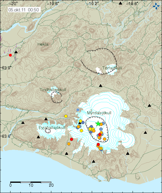
and this is this morning
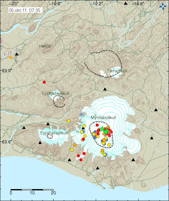
I think we may have a problem Houston.
ETA: Added the SNB graph here. Looks as if there is tremor starting. We may see an eruption in the next couple of days if this carries on.
edit on 5/10/2011 by PuterMan because: (no reason given)
reply to post by PuterMan
IT IS OFFICIAL. PuterMan is a doddery old fool.
My sincere apologies to all and sundry for an unforgivable error on my part when listing Bermuda. I am normally very careful about these things, but I missed the - (minus) sign off the longitude. Bermuda is of course WEST and not EAST,
The correct list is as follows:
Source
My list was actually on the border between Afghanistan and Pakistan in a fairly remote area.
Perception and reality are the same in this case!
My thank to jjjtir for pointing out my stupidity.
IT IS OFFICIAL. PuterMan is a doddery old fool.
My sincere apologies to all and sundry for an unforgivable error on my part when listing Bermuda. I am normally very careful about these things, but I missed the - (minus) sign off the longitude. Bermuda is of course WEST and not EAST,
The correct list is as follows:
Year,Month,Day,Time(hhmmss.mm)UTC,Latitude,Longitude,Magnitude,Depth,Catalog
1988,06,26,041831.25, 31.331, -64.783,5.1, 10,PDE
1988,08,27,070438.75, 31.201, -64.809,5.3, 10,PDE
1992,12,06,053922.15, 31.442, -66.108,3.9, 10,PDE
1995,07,02,033510.44, 31.011, -65.170,4.7, 10,PDE
1996,12,22,201353.55, 32.224, -65.447,4.4, 10,PDE
2011,04,18,153803.89, 32.460, -65.597,4.6, 10,PDE-W
Source
My list was actually on the border between Afghanistan and Pakistan in a fairly remote area.
Perception and reality are the same in this case!
My thank to jjjtir for pointing out my stupidity.
reply to post by PuterMan
Oh I am so relieved I was beginning to think you were not human as you never seem to error. You do such a brilliant job here so thank you
Oh I am so relieved I was beginning to think you were not human as you never seem to error. You do such a brilliant job here so thank you
reply to post by PuterMan
Doddery old fool, my eye! You are the man who wrote to the USGS/NEIC to tell them they had a quake listed at entirely the wrong magnitude -- and a bunch of professional seismologists found that a glaring error had slipped them by and after your message they saw that you were right -- and fixed their error!
Seriously though, we appreciate your dedication, insight and plain-spoken honesty, Puterman! No-one is perfect and a very rare slip-up like the one you made (but then corrected!) is both understandable and quite forgiveable.
You're all right by me.
Best regards,
Mike
Meanwhile, I see that there's been a mag 3.4 in Arkansas:
Source: USGS
Pretty shallow quake, that one. Hmmm... Considering how close it is to Guy, possibly linked to fracking?
Mike
Doddery old fool, my eye! You are the man who wrote to the USGS/NEIC to tell them they had a quake listed at entirely the wrong magnitude -- and a bunch of professional seismologists found that a glaring error had slipped them by and after your message they saw that you were right -- and fixed their error!
Seriously though, we appreciate your dedication, insight and plain-spoken honesty, Puterman! No-one is perfect and a very rare slip-up like the one you made (but then corrected!) is both understandable and quite forgiveable.
You're all right by me.
Best regards,
Mike
Meanwhile, I see that there's been a mag 3.4 in Arkansas:
Earthquake Details
* This event has been reviewed by a seismologist.
Magnitude 3.4
Date-Time
* Wednesday, October 05, 2011 at 09:38:30 UTC
* Wednesday, October 05, 2011 at 04:38:30 AM at epicenter
* Time of Earthquake in other Time Zones
Location 35.367°N, 92.271°W
Depth 4.7 km (2.9 miles)
Region ARKANSAS
Distances
* 5 km (3 miles) WSW (252°) from Quitman, AR
* 7 km (5 miles) NE (51°) from Guy, AR
* 13 km (8 miles) E (90°) from Damascus, AR
* 35 km (22 miles) NNE (28°) from Conway, AR
* 70 km (44 miles) N (4°) from Little Rock, AR
* 405 km (252 miles) SSW (207°) from St. Louis, MO
Location Uncertainty horizontal +/- 0.4 km (0.2 miles); depth +/- 0.5 km (0.3 miles)
Parameters NST= 14, Nph= 19, Dmin=4 km, Rmss=0.2 sec, Gp= 61°,
M-type="Nuttli" surface wave magnitude (mbLg), Version=B
Source
* Cooperative New Madrid Seismic Network
Event ID nm100511a
Source: USGS
Pretty shallow quake, that one. Hmmm... Considering how close it is to Guy, possibly linked to fracking?
Mike
edit on 5/10/11 by JustMike because: I added a bit and fixed a wretched typo.
this is a copy of what i wrote on the Arkansas thread...
There have been four quakes over night in Arkansas. Mostly near Quitman. I don't know what to say.Or rather, don't want to say what I really believe. I had really hoped that this story was over. The injection wells closed. The Guy/Greenbrier swarm ended. But the damage has already been done. Every day I watch the siesmos in Arkansas. Because. Because I know they are continuing to frack, and they are continuing to disposal injection outside of the exclusion zone. The entire area is seismic.
In my humble, non-expert opinion, the sequence of events are leading to a major earthquake. Just like 1811-1812.
It should be evident that Quitman is north of Guy and it may be that the Guy/Greenbrier fault extends to Quitman. One of last night's quakes was in Guy.
I actually think it's an artificial fault (meaning man-made) created by the injections. The fault could rupture from Guy to Quitman. If this is the case. We are in for another swarm. With larger earthquakes to follow.
I know one of my recent posts were extreme and seem over the top. But it's wasn't. I w
I knew I was right. Those damned Ohio quakes weren't natural. Once again. It's man made.
www.wfmj.com...
Still checking for more proof.
www.wfmj.com...
Still checking for more proof.
edit on 5-10-2011 by Robin Marks because: (no reason given)
reply to post by Robin Marks
Forgive me if my observation is wrong and or laughable.
It seems to me that the swarms and volcanic eruptions resemble events a couple of hundred years ago when in concert, volcanic activity and EQ's were perhaps devastating to the US. This observation is not to place fear in anyone.....just being honest.
Again, I may be totally off and or wrong but it seems as though activity in regards to EQ's and Volcanoes may indeed get interesting.
New Madrid, California, and other areas in the US seem pretty vulnerable considering all the swarms and volcanic activity. Time will most definitely tell. In the mean time though...I am remaining alert and will be taking notes from all you guys and relying on your expertise to guide.
new topics
-
Are you ready for the return of Jesus Christ? Have you been cleansed by His blood?
Religion, Faith, And Theology: 33 minutes ago -
Chronological time line of open source information
History: 1 hours ago -
A man of the people
Diseases and Pandemics: 3 hours ago -
Ramblings on DNA, blood, and Spirit.
Philosophy and Metaphysics: 3 hours ago -
4 plans of US elites to defeat Russia
New World Order: 4 hours ago -
Thousands Of Young Ukrainian Men Trying To Flee The Country To Avoid Conscription And The War
Other Current Events: 8 hours ago -
12 jurors selected in Trump criminal trial
US Political Madness: 11 hours ago -
Iran launches Retalliation Strike 4.18.24
World War Three: 11 hours ago -
Israeli Missile Strikes in Iran, Explosions in Syria + Iraq
World War Three: 11 hours ago
top topics
-
George Knapp AMA on DI
Area 51 and other Facilities: 17 hours ago, 26 flags -
Israeli Missile Strikes in Iran, Explosions in Syria + Iraq
World War Three: 11 hours ago, 17 flags -
Thousands Of Young Ukrainian Men Trying To Flee The Country To Avoid Conscription And The War
Other Current Events: 8 hours ago, 6 flags -
Iran launches Retalliation Strike 4.18.24
World War Three: 11 hours ago, 6 flags -
Not Aliens but a Nazi Occult Inspired and then Science Rendered Design.
Aliens and UFOs: 17 hours ago, 5 flags -
12 jurors selected in Trump criminal trial
US Political Madness: 11 hours ago, 4 flags -
4 plans of US elites to defeat Russia
New World Order: 4 hours ago, 2 flags -
A man of the people
Diseases and Pandemics: 3 hours ago, 2 flags -
Chronological time line of open source information
History: 1 hours ago, 2 flags -
Ramblings on DNA, blood, and Spirit.
Philosophy and Metaphysics: 3 hours ago, 1 flags
active topics
-
Are you ready for the return of Jesus Christ? Have you been cleansed by His blood?
Religion, Faith, And Theology • 4 • : TheGoodNews -
Thousands Of Young Ukrainian Men Trying To Flee The Country To Avoid Conscription And The War
Other Current Events • 7 • : Xtrozero -
4 plans of US elites to defeat Russia
New World Order • 24 • : twistedpuppy -
BREAKING: O’Keefe Media Uncovers who is really running the White House
US Political Madness • 16 • : Hakaiju -
Fossils in Greece Suggest Human Ancestors Evolved in Europe, Not Africa
Origins and Creationism • 65 • : Xtrozero -
The Tories may be wiped out after the Election - Serves them Right
Regional Politics • 24 • : crayzeed -
A man of the people
Diseases and Pandemics • 7 • : TheMichiganSwampBuck -
Israeli Missile Strikes in Iran, Explosions in Syria + Iraq
World War Three • 54 • : CarlLaFong -
12 jurors selected in Trump criminal trial
US Political Madness • 30 • : RazorV66 -
Meet Catturd who has been swatted 3 times
General Conspiracies • 22 • : 7dayhome