It looks like you're using an Ad Blocker.
Please white-list or disable AboveTopSecret.com in your ad-blocking tool.
Thank you.
Some features of ATS will be disabled while you continue to use an ad-blocker.

Quake Watch 2011
page: 287share:
Another one for Japan:
Be Well.
Magnitude
4.7
Date-Time
Friday, September 30, 2011 at 17:20:04 UTC
Saturday, October 01, 2011 at 02:20:04 AM at epicenter
Time of Earthquake in other Time Zones
Location
35.371°N, 140.827°E
Depth
49.5 km (30.8 miles)
Region
NEAR THE EAST COAST OF HONSHU, JAPAN
Distances
103 km (64 miles) ESE of TOKYO, Japan
109 km (67 miles) E of Yokohama, Honshu, Japan
114 km (70 miles) SSE of Mito, Honshu, Japan
156 km (96 miles) SSE of Utsunomiya, Honshu, Japan
Location Uncertainty
horizontal +/- 21.3 km (13.2 miles); depth +/- 10.5 km (6.5 miles)
Parameters
NST= 38, Nph= 38, Dmin=267.2 km, Rmss=1.17 sec, Gp=119°,
M-type=body wave magnitude (Mb), Version=5
Source
Magnitude: USGS NEIC (WDCS-D)
Location: USGS NEIC (WDCS-D)
Event ID
usc00062ws
Be Well.
reply to post by muzzy
Needless to say USGS and the lap dog have it at 4.8
You sure it is a 5.8. Sure is not showing anywhere. Nothing hardly at all on LISS and it is very small on SNZO SNZO.IU.00.BHZ.2011.273
Phase data on USGS has virtually nothing above 5mb. They are quoting 4.8mb and 4.7ML
Needless to say USGS and the lap dog have it at 4.8
You sure it is a 5.8. Sure is not showing anywhere. Nothing hardly at all on LISS and it is very small on SNZO SNZO.IU.00.BHZ.2011.273
Phase data on USGS has virtually nothing above 5mb. They are quoting 4.8mb and 4.7ML
reply to post by PuterMan
(with that quake) being on the west side of the Kermadec Ridge SNZO doesn't pick those up so good, only the east (Trench) side
Decent trace on Urewera on the East Cape though
(with that quake) being on the west side of the Kermadec Ridge SNZO doesn't pick those up so good, only the east (Trench) side
Decent trace on Urewera on the East Cape though
edit on 30-9-2011 by muzzy because: (clarification in backets)
Here's the map for recent US quakes.
earthquake.usgs.gov...
Forgetting the west, the eastern US is very quiet. The only areas showing activity over the last week are Ohio and NMSZ. I know it's cliche', but it seems too quiet. I liked it when there is a lull. Because very soon, we'll see a return in activity and it is very interesting to follow the newest batch. Also, worldwide quakes are still relatively modest.
"it's quiet, a little too quiet."
I tried to find a video compilation of movies with the quote. Surprisingly, no one's done one yet.
reply to post by Robin Marks
Hi regularly keep an eye on this thread, so hope you don't mind me asking this...could the quietness be due to extra meteorite activity?
I can't put a finger on it , just wonder if there could be a connection with the NEAS peaking at the moment?
Hi regularly keep an eye on this thread, so hope you don't mind me asking this...could the quietness be due to extra meteorite activity?
I can't put a finger on it , just wonder if there could be a connection with the NEAS peaking at the moment?
reply to post by muzzy
OK, will look at that.
Now cop a load of this.
From JMO. No one else recorded this quake until today or yesterday after the 7 days had passed.
neic.usgs.gov...
Um beg pardon what eh excuse me? Emphasis by me in both cases.
Nothing on EMSC www.emsc-csem.org... (that may not hit the right page as time moves on. You need to move yourself to the 18th)
Is this a mistake? If so it is a very big one! See it here in the 8-30 day list
I have emailed USGS to query this.
ETA: Had to snag it.
OK, will look at that.
Now cop a load of this.
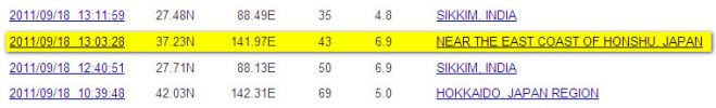
Date/Time UTC,Latitude,Longitude,Magnitude,Depth(Km),Location
2011-09-18 13:03:00, 37.300, 141.800, 4.6, 40.0, Fukushima-Ken Oki
From JMO. No one else recorded this quake until today or yesterday after the 7 days had passed.
Magnitude 6.9
Date-Time Sunday, September 18, 2011 at 13:03:28 (UTC) - Coordinated Universal Time
Sunday, September 18, 2011 at 10:03:28 PM local time at epicenter
Time of Earthquake in other Time Zones
Location 37.23N 141.97E
Depth 43 kilometers
Region NEAR THE EAST COAST OF HONSHU, JAPAN
neic.usgs.gov...
Um beg pardon what eh excuse me? Emphasis by me in both cases.
Nothing on EMSC www.emsc-csem.org... (that may not hit the right page as time moves on. You need to move yourself to the 18th)
Is this a mistake? If so it is a very big one! See it here in the 8-30 day list
I have emailed USGS to query this.
ETA: Had to snag it.

edit on 30/9/2011 by PuterMan because: (no reason given)
reply to post by Dr Expired
In all honesty, I don't think meteors would change earthquake activity. I am more inclined to believe that the lull is because the east has released lots of energy over the last few months and is out of steam. Actually, I'm not even going to listen to myself. I don't know. But I've very curious to see what happens next.
In all honesty, I don't think meteors would change earthquake activity. I am more inclined to believe that the lull is because the east has released lots of energy over the last few months and is out of steam. Actually, I'm not even going to listen to myself. I don't know. But I've very curious to see what happens next.
Want a laugh?
Where would you find a siesmo station called Dead Sheep, or Gay Alien, or Valley Of Doom 1?
Take a look at the XO network! which is part of the University of Leicester experimental network (United Kingdom) and has seismos all over the world - many with some very off names!.
Where would you find a siesmo station called Dead Sheep, or Gay Alien, or Valley Of Doom 1?
Take a look at the XO network! which is part of the University of Leicester experimental network (United Kingdom) and has seismos all over the world - many with some very off names!.
edit on 30/9/2011 by PuterMan because: (no reason given)
reply to post by Robin Marks
Nice hum happening in Yellowstone at Norris Junction.
... obligatory 2nd line.
Nice hum happening in Yellowstone at Norris Junction.
... obligatory 2nd line.
reply to post by LexiconV
I'm not terribly interested in, or knowledgeable about Yellowstone's transmission system. But I do know enough to know it's just a technical problem. There's nothing happening at Yellowstone. It's quiet- a little too quiet.
I may just rant about this particular subject on the Yellowstone thread. The lack of activity has me wondering about the previous two major swarms. In retrospect, I am now starting to think we came very close to have an eruption, a little too close.
edit on 30-9-2011 by Robin Marks because: (no reason given)
Originally posted by Robin Marks
reply to post by Dr Expired
In all honesty, I don't think meteors would change earthquake activity. I am more inclined to believe that the lull is because the east has released lots of energy over the last few months and is out of steam. Actually, I'm not even going to listen to myself. I don't know. But I've very curious to see what happens next.
everyone mistakes the messenger,,,,"I don't think meteors would",,,
-cycle,,,,
(orib//comet/haileys comet,,,cycle,,,meteor,,,)
with the message,,,,,,,,,,,,,,,,,,,,,,,,,,,,,
,,,,,,,,,,,,,,,,,,,,,,,,,,,,,,,,,,,,,,,,,,,,,,,,,,,,,,"change earthquake activity"
---------------------------------------------------------------------------
everyone mistakes the messenger with the message these days
it seems.
edit on 30-9-2011 by BobAthome because: (no reason given)
Comets,,, Heralds of Events Throughout History,,,,,,a cycle of history, repeating,,
hmmmm
edit on 30-9-2011 by BobAthome because: (no reason given)
reply to post by PuterMan
some good ones in there alright. Students eh!
Theres a location that pops up on the NZ lists quite a lot on the Akatarawa Fault just on the other side of the Tararua Mts from where I live, when you do a placename searchof the co-ords it comes up as Three Skulls Rd there must be a story behind that name, I've driven past the turnoff many times buthave never turned up the road .............. perhaps in the fear of becoming the Fourth Skull
a pretty narrow winding road in the mountains
edit on 30-9-2011 by muzzy because: (no reason given)
reply to post by PuterMan
indeed I see on that usgs link here too, but notice there is no phase data
must be a mistake, a 4.6 japan style sure doesn't make a 6.9 under any conversion
I ususally scan the lists for 6's and check the phase data if they look close to a 7, but don't recall checking that on out
indeed I see on that usgs link here too, but notice there is no phase data
must be a mistake, a 4.6 japan style sure doesn't make a 6.9 under any conversion
I ususally scan the lists for 6's and check the phase data if they look close to a 7, but don't recall checking that on out
Magnitude 5.6
Date-Time
Saturday, October 01, 2011 at 10:54:34 UTC
Saturday, October 01, 2011 at 09:54:34 PM at epicenter
Location 48.967°S, 164.348°E
Depth 34.9 km (21.7 miles)
Region OFF WEST COAST OF THE SOUTH ISLAND, N.Z.
Distances
215 km (134 miles) NW (326°) from Auckland Island, New Zealand
414 km (257 miles) SW (225°) from Invercargill, New Zealand
577 km (358 miles) SW (231°) from Dunedin, New Zealand
1181 km (734 miles) SW (220°) from WELLINGTON, New Zealand
Location Uncertainty horizontal +/- 18.5 km (11.5 miles); depth +/- 2.9 km (1.8 miles)
Parameters NST= 85, Nph= 89, Dmin=357.3 km, Rmss=1.16 sec, Gp= 86°,
M-type=body wave magnitude (Mb), Version=6
Source
Magnitude: USGS NEIC (WDCS-D)
Location: USGS NEIC (WDCS-D)
Event ID usc000638g
earthquake.usgs.gov...
Close to the Auckland Island on 'the crack' running south.
edit on 1/10/2011 by PuterMan because: (no reason given)
Alaska
whoa~!!
are we having a problem !!?? !! Click on the global view and Alaska is nearly dead center of the globe.. and on Rencent quakes....
and here
in the past 7 days
whoa~!!
are we having a problem !!?? !! Click on the global view and Alaska is nearly dead center of the globe.. and on Rencent quakes....
and here
in the past 7 days
Nevada anyone....
Magnitude
4.6
Date-Time
Saturday, October 01, 2011 at 07:07:01 UTC
Saturday, October 01, 2011 at 12:07:01 AM at epicenter
Time of Earthquake in other Time Zones
Location
38.883°N, 118.781°W
Depth
10.2 km (6.3 miles)
Region
NEVADA
Distances
10 km (6 miles) SSE (157°) from Schurz, NV
35 km (22 miles) ESE (109°) from Yerington, NV
37 km (23 miles) WSW (246°) from Rawhide, NV
42 km (26 miles) NNW (341°) from Hawthorne, NV
236 km (147 miles) E (80°) from Sacramento, CA
Location Uncertainty
horizontal +/- 2.7 km (1.7 miles); depth +/- 4.3 km (2.7 miles)
Parameters
NST= 9, Nph= 13, Dmin=36.2 km, Rmss=0.1 sec, Gp=212°,
M-type=local magnitude (ML), Version=8
Source
Seismological Laboratory, University of Nevada, Reno
Event ID
nn00349692
reply to post by muzzy
MAJO.IU.00.BHZ.2011.261
The seismo for that one.
Plot for the day
No 6.9 That I can see. The quake at around 1300 is Sikim.
MAJO.IU.00.BHZ.2011.261
The seismo for that one.
Plot for the day
No 6.9 That I can see. The quake at around 1300 is Sikim.
edit on 1/10/2011 by PuterMan because: (no reason given)
reply to post by PuterMan
you are more accurate than usgs
"W of the South Island" did the person who wrote the text bother to look at their own map
I'd call it S of the South Island or Auckland Islands.
Of course they use the Flinn-Engdahl seismic and geographical regionalization scheme to get their locations but surely use some common sense here, some people (like me for instance) would see that location on the list and be looking for something off Fiordland.
Just saying
Although its outside Geonets coverage area they have it on the Recent Quakes list anyway (not on the search results yet)
5.9 Puysegur Trench (the crack)
Harping on about the usgs location still, you know I have never seen these FE Regions mapped, apart from the 757 larger areas which puts the whole of NZ in Region 11.
apparently there are 1713 sub regions according to EMSC
The region name is called "Flinn-Engdahl +" region. Flinn-Engdahl (FE) regions have been defined in 1974 (Flinn et al., 1974) and revised in 1995 (Young et al.; 1995). The boundaries of these 757 regions are defined at one-degree intervals and therefore differ from irregular political boundaries. An improvement of classical FE regions has been proposed by B. Presgrave from the USGS/NEIC and called FE+ regions, in order to better bit political boundaries. Those 1713 FE+ regions are used by EMSC to better labelled the region where an earthquake occurred.
edit on
1-10-2011 by muzzy because: (no reason given)
new topics
-
A man of the people
Diseases and Pandemics: 46 minutes ago -
Ramblings on DNA, blood, and Spirit.
Philosophy and Metaphysics: 1 hours ago -
4 plans of US elites to defeat Russia
New World Order: 2 hours ago -
Thousands Of Young Ukrainian Men Trying To Flee The Country To Avoid Conscription And The War
Other Current Events: 6 hours ago -
12 jurors selected in Trump criminal trial
US Political Madness: 8 hours ago -
Iran launches Retalliation Strike 4.18.24
World War Three: 8 hours ago -
Israeli Missile Strikes in Iran, Explosions in Syria + Iraq
World War Three: 9 hours ago
top topics
-
George Knapp AMA on DI
Area 51 and other Facilities: 15 hours ago, 26 flags -
Israeli Missile Strikes in Iran, Explosions in Syria + Iraq
World War Three: 9 hours ago, 16 flags -
Louisiana Lawmakers Seek to Limit Public Access to Government Records
Political Issues: 17 hours ago, 7 flags -
Iran launches Retalliation Strike 4.18.24
World War Three: 8 hours ago, 6 flags -
Not Aliens but a Nazi Occult Inspired and then Science Rendered Design.
Aliens and UFOs: 15 hours ago, 5 flags -
Thousands Of Young Ukrainian Men Trying To Flee The Country To Avoid Conscription And The War
Other Current Events: 6 hours ago, 4 flags -
12 jurors selected in Trump criminal trial
US Political Madness: 8 hours ago, 4 flags -
4 plans of US elites to defeat Russia
New World Order: 2 hours ago, 2 flags -
Ramblings on DNA, blood, and Spirit.
Philosophy and Metaphysics: 1 hours ago, 1 flags -
A man of the people
Diseases and Pandemics: 46 minutes ago, 0 flags
active topics
-
Mood Music Part VI
Music • 3060 • : TheWoker -
4 plans of US elites to defeat Russia
New World Order • 10 • : andy06shake -
Elites disapearing
Political Conspiracies • 32 • : SchrodingersRat -
A man of the people
Diseases and Pandemics • 1 • : chr0naut -
Thousands Of Young Ukrainian Men Trying To Flee The Country To Avoid Conscription And The War
Other Current Events • 3 • : Consvoli -
British TV Presenter Refuses To Use Guest's Preferred Pronouns
Education and Media • 67 • : Consvoli -
The Fight for Election Integrity Continues -- Audits, Criminal Investigations, Legislative Reform
2024 Elections • 4138 • : IndieA -
Fossils in Greece Suggest Human Ancestors Evolved in Europe, Not Africa
Origins and Creationism • 63 • : Consvoli -
Mandela Effect - It Happened to Me!
The Gray Area • 112 • : CCoburn -
So I saw about 30 UFOs in formation last night.
Aliens and UFOs • 31 • : Encia22