It looks like you're using an Ad Blocker.
Please white-list or disable AboveTopSecret.com in your ad-blocking tool.
Thank you.
Some features of ATS will be disabled while you continue to use an ad-blocker.

Quake Watch 2011
page: 109share:
Posted: Fri, Apr 29 2011. 12:36 AM IST
New warning on earthquake in Himalayan region
Pressure in the region’s crust is building up and could be released far more powerfully than previously imagined, the researchers warn
Bhargavi Kerur & Jacob P. Koshy
www.livemint.com/2011/04/29003645/New-warning-on-earthquake-in-H.html
Revisiting the earthquake sources in the Himalaya: Perspectives on past seismicity
Tectonophysics
Volume 504, Issues 1-4, 9 May 2011, Pages 75-88
dx.doi.org/10.1016/j.tecto.2011.03.001
Free fulltext
jjjtir.files.wordpress.com/2011/04/revisiting-the-earthquake-sources-in-the-himalaya.pdf
New warning on earthquake in Himalayan region
Pressure in the region’s crust is building up and could be released far more powerfully than previously imagined, the researchers warn
Bhargavi Kerur & Jacob P. Koshy
www.livemint.com/2011/04/29003645/New-warning-on-earthquake-in-H.html
Bangalore/New Delhi: North India could experience a powerful earthquake, it could happen sooner than expected and wreak more damage than previously estimated, according to the findings of a research study by scientists at Bangalore’s respected Indian Institute of Science (IISc).
India is nowhere close to being ready to deal with a powerful seismic shock, according to an official at the National Disaster Management Authority (NDMA).
The researchers analysed earthquakes over the years in the seismically-volatile northern Himalayan region. Their study will be published in next month’s issue of the Journal of Tectonophysics, a peer-reviewed journal.
Also See | Tremor lines (Graphic) [atsimg]http://files.abovetopsecret.com/images/member/ef2b9ccd0d03.jpg[/atsimg]
For at least three decades now, seismologists have been unanimous that a major quake (exceeding magnitude 8.2) is imminent somewhere between Bihar and Nepal, and Kangra (Himachal Pradesh), referred to as the central conflict zone, as well as around Delhi and Uttarkashi. The IISc scientists point out that those studies assume that the last major quake that rocked the region happened 500 years ago, whereas their calculations and on-site excavations suggest that such a quake happened 1,000 years ago.
(...)
Revisiting the earthquake sources in the Himalaya: Perspectives on past seismicity
Tectonophysics
Volume 504, Issues 1-4, 9 May 2011, Pages 75-88
dx.doi.org/10.1016/j.tecto.2011.03.001
Free fulltext
jjjtir.files.wordpress.com/2011/04/revisiting-the-earthquake-sources-in-the-himalaya.pdf
Minnesota????
2.5 MINNESOTA45.88°N -95.47°W 5Km Deep 2011-04-29 07:20:13 UTC2011-04-29 02:20:13 LOCAL US2011KHA1
earthquake.usgs.gov...
2.5 MINNESOTA45.88°N -95.47°W 5Km Deep 2011-04-29 07:20:13 UTC2011-04-29 02:20:13 LOCAL US2011KHA1
earthquake.usgs.gov...
reply to post by ButterCookie
Weird, eh? But they have had eq's in the past. Here is a link to to a USGS history summary for MN.
earthquake.usgs.gov...
Weird, eh? But they have had eq's in the past. Here is a link to to a USGS history summary for MN.
earthquake.usgs.gov...
is it me? or is the Vanuatu region getting ready for big one? seen here earthquake.usgs.gov... and
then what about the CA/NV region? is it building up as well?? This is just a thought, what if the hot zone is moving east?
earthquake.usgs.gov...
earthquake.usgs.gov...
reply to post by bekod
A big one could happen any time in the Vanuatu Region, but this just looks like a Swarm, the magnitudes are all in the low 5's.
Just had a quick look through the Networks that cover the area
usgs has 6
emsc 5
gsras 5
geofon 3
ga 0
the aussies (ga) are the closest, they must be tired and sleeping in after the big wedding
edit on 29-4-2011 by muzzy because: (no reason
given)
reply to post by jjjtir
maybe, but I think the next Major quake Globally will be in China (because of the Japan 9.0)
Hope its not today, I have enough on my plate plotting the Vanuatu Swarm
maybe, but I think the next Major quake Globally will be in China (because of the Japan 9.0)
edit on 29-4-2011 by muzzy because: (no reason given)
Hope its not today, I have enough on my plate plotting the Vanuatu Swarm
edit on 29-4-2011 by muzzy because: (no reason given)
OK this isn't unreal but it is very rare. We had an earthquake this morning measuring 2.5(i know very minute) but none the less it was an earthquake.
i have only known of one other quake in MN that happened near or in Minneapolis . just thought i would post this one as it is happening around this
weird time we are having on this rock right now.
Peace.
Peace.
edit on 07/16/2009 by Lichter daraus because: forgot a detail
REF:3504211
LAT/LONG: -40.93597, 174.77856
UTC: 2011/4/28 16:11:35
NZST: 2011/4/29 4:11:35
DEPTH: 5km
MAG: 2.686ML
LOCATION: o/s E of Raumati South, Kapiti, Wellington
magma.geonet.org.nz...
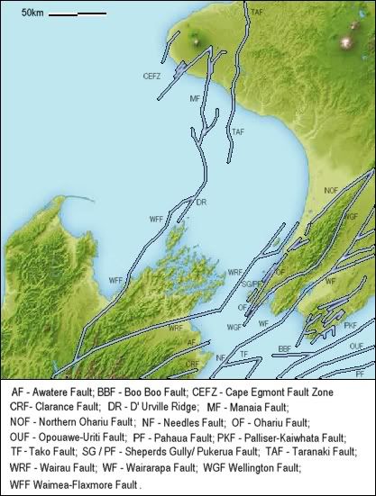
Just a small one early yesterday, but only 17.53km from my house. Didn't feel it.Shallow for the Wairau Fault, usually the quakes are at 50km depths
edit on 29-4-2011 by muzzy because: (no reason given)
Just been rudely awakened by a close 5.2 9km down here in Canterbury, New Zealand
NOT nice..
www.geonet.org.nz...
NOT nice..
www.geonet.org.nz...
I wondered if you felt it (surely). Not much of a shake here in the City, seeing as it was in the Lees Valley area, but the dogs did respond in their
usual manners (barking, hiding, whining). Hope you're o.k.
Keep an eye on Eyrewell Forest. There have been quite a few in that area.
Keep an eye on Eyrewell Forest. There have been quite a few in that area.
reply to post by aorAki
Friend in Springfield has damage. Funnily enough after the few 3's we'd had there recently I had thought we might get a bigger one - stress transfer to the west end? Or.. is it Greendale at all - that 5.2 was up nearer the Porter Pass fault isn't it?
Friend in Springfield has damage. Funnily enough after the few 3's we'd had there recently I had thought we might get a bigger one - stress transfer to the west end? Or.. is it Greendale at all - that 5.2 was up nearer the Porter Pass fault isn't it?
USGS reporting another mag 5 range quake in the Gulf of California:
Magnitude 5.0
Date-Time Friday, April 29, 2011 at 22:31:59 UTC
Friday, April 29, 2011 at 03:31:59 PM at epicenter
Time of Earthquake in other Time Zones
Location 28.838°N, 113.088°W
Depth 10.5 km (6.5 miles)
Region GULF OF CALIFORNIA
this is the 2nd, there was another only a few days ago:
Magnitude 5.6
Date-Time Tuesday, April 26, 2011 at 21:10:26 UTC
Tuesday, April 26, 2011 at 02:10:26 PM at epicenter
Time of Earthquake in other Time Zones
Location 27.439°N, 111.598°W
Depth 15.1 km (9.4 miles)
Region GULF OF CALIFORNIA
earthquake.usgs.gov...
both pretty shallow
reply to post by MoorfNZ
I've got it between Black Hill and the Townsend River, just north of the Townsend Fault.
data.gns.cri.nz...
I've got it between Black Hill and the Townsend River, just north of the Townsend Fault.
data.gns.cri.nz...
Originally posted by aorAki
Keep an eye on Eyrewell Forest. There have been quite a few in that area.
Not lately that I noticed, but do you think there is a relevance of that location to a change in where the Greendale Fault is trending
There was that Swarm there just the day before the 6.3
There was a 3.1 a hundred km off Kaikoura just a bit over an hour prior to the 5.2, thats the 2nd time I have seen one out there, adding more weight to the theory that the PP Tectonic Plate margin has moved south from Marlborough
This is making me very nervous. Are we gearing up for a major quake? Had one of those headaches yesterday -
Source
4.3 2011/04/30 06:07:53 28.764 -113.178 10.0 130 km ( 81 mi) NE of Guerrero Negro, Mexico
5.0 2011/04/29 22:31:59 28.838 -113.088 10.5 142 km ( 88 mi) NE of Guerrero Negro, Mexico
5.6 2011/04/26 21:10:26 27.439 -111.598 15.1 69 km ( 43 mi) E of Santa Rosal�a, Mexico
2.8 2011/04/26 18:16:52 31.996 -114.930 11.1 37 km ( 23 mi) SSE of Guadalupe Victoria, Mexico
Source
Geez the 29th mag 5+ was amess, took me ages to sort out the list, 26 individual quakes
I think I got it right
Last 7 days 5+
I've been sorting them by UTC time, but some of the times didn't match up between Networks, one usgs quake was 3 hours after the others had it, I'm presuming it was the same quake.
5.3, 2011/04/29 13:12:46, 21.2, 122.02, 186, Taiwan Region, emsc
5.7, 2011/04/29 13:12:46, 21.14, 122.1, 200, Taiwan region, gsras
5.3, 2011/04/29 13:12:47, 21.22, 122.04, 187, Taiwan Region, gfz
5.5, 2011/04/29 16:00:41, 21.182, 121.9798, 176.7, Taiwan region, usgs
and quakes with the same time but different locations didn't help
5.5, 2011/04/29 16:00:41, 21.182, 121.9798, 176.7, Taiwan region, usgs
5.1, 2011/04/29 16:00:41, -19.59, 167.73, 33, Vanuatu Islands region, gsras
another one where usgs are half an hour later, I'm not sure these are the same quake?
5, 2011/04/29 07:36:20, -19.21, 167.92, 10, Vanuatu Islands Region, gfz
5.3, 2011/04/29 07:36:21, -19.29, 167.81, 33, Vanuatu Islands region, gsras
5, 2011/04/29 07:36:27, -19.2, 167.81, 60, Vanuatu Region, emsc
5, 2011/04/29 08:56:48, -19.2328, 167.7221, 24.4, Vanuatu region, usgs
I hope I have the times right on my Excel file, usgs still giving me problems converting from text to time, all the other Networks convert to am/pm in the column, except usgs
The New Hebrides Trench (Vanuatu) was a real mess
reply to post by muzzy
Odd that. This is the Taiwan list using the 7 day text file
Here are the ones I have for Vanuatu
[atsimg]http://files.abovetopsecret.com/images/member/f3c361360076.jpg[/atsimg]
The Russians with their 5.1 for Taiwan look off the mark
5.1, 2011/04/24 22:53:37, 21.08, 121.41, 33, Taiwan region, gsras
I would have said from the USGS phase data that it was actually less than the 4.9 they have it at. They seem to have a knack of just lowering things enough normally to 'miss' a next bracket!
Odd that. This is the Taiwan list using the 7 day text file
Date/Time UTC,Latitude,Longitude,Magnitude,Depth(Km),Location
2011-04-30 08:35:38, 24.688, 121.873, 4.9, 74.6, Taiwan
2011-04-29 13:12:45, 21.182, 121.979, 5.5, 176.7, Taiwan Region
2011-04-24 22:53:37, 21.083, 121.218, 4.9, 21.5, Taiwan Region
Here are the ones I have for Vanuatu
Date/Time UTC,Latitude,Longitude,Magnitude,Depth(Km),Location
2011-04-30 12:21:00, -17.654, 168.177, 4.6, 79.6, Vanuatu
2011-04-29 16:00:41, -19.313, 167.705, 5.0, 27.0, Vanuatu Region
2011-04-29 13:08:31, -19.369, 167.666, 5.0, 27.2, Vanuatu Region
2011-04-29 09:47:13, -19.386, 167.842, 5.0, 26.4, Vanuatu Region
2011-04-29 09:38:30, -19.262, 167.875, 5.2, 27.2, Vanuatu Region
2011-04-29 07:36:23, -19.232, 167.722, 5.0, 24.4, Vanuatu Region
2011-04-29 07:21:12, -19.147, 167.912, 5.1, 29.4, Vanuatu Region
2011-04-25 13:38:53, -15.744, 172.990, 5.3, 11.3, Vanuatu Region
[atsimg]http://files.abovetopsecret.com/images/member/f3c361360076.jpg[/atsimg]
The Russians with their 5.1 for Taiwan look off the mark
5.1, 2011/04/24 22:53:37, 21.08, 121.41, 33, Taiwan region, gsras
I would have said from the USGS phase data that it was actually less than the 4.9 they have it at. They seem to have a knack of just lowering things enough normally to 'miss' a next bracket!
edit on 30/4/2011 by PuterMan because: To add more "stuff" 'cos "stuff" is good.
reply to post by PuterMan
Hmmm, something went wrong at my end then.
I'll check it out later today when I do the 30th.
that 16:0041 looks out of place
I may have mucked up the rows when I transfered from my usgs file to the compliation file.
I have a file for each Network
Hmmm, something went wrong at my end then.
I'll check it out later today when I do the 30th.
that 16:0041 looks out of place
I may have mucked up the rows when I transfered from my usgs file to the compliation file.
I have a file for each Network
Earthquake Details
This event has been reviewed by a seismologist.
Magnitude 3.3
Date-Time Sunday, May 01, 2011 at 04:13:55 UTC
Saturday, April 30, 2011 at 09:13:55 PM at epicenter
Time of Earthquake in other Time Zones
Location 46.405°N, 119.257°W
Depth 2.6 km (1.6 miles) set by location program
Region WASHINGTON
Distances 14 km (9 miles) N (8°) from Richland, WA
15 km (9 miles) NNE (31°) from West Richland, WA
18 km (11 miles) NNW (341°) from West Pasco, WA
24 km (15 miles) NNW (341°) from Kennewick, WA
199 km (124 miles) SW (225°) from Spokane, WA
270 km (168 miles) ESE (119°) from Seattle, WA
Location Uncertainty horizontal +/- 0.4 km (0.2 miles); depth fixed by location program
Parameters NST= 38, Nph= 40, Dmin=3 km, Rmss=0.24 sec, Gp= 65°,
M-type=duration magnitude (Md), Version=1
Source Pacific Northwest Seismograph Network
Event ID uw05010413
USGS
edit on 1-5-2011 by UtahRosebud because: Updated post
to show after it was reviewed by seismologist
I was just wondering, in the following Mt.St. Helens Seismogram, HERE
if the odd activity signatures could be caused by possible solar flares?Solar disturbances involving the atmosphere?
Also, noticed on Intellicast that the earthquake detection is only showing up with red dots? Usually there is multiple colors representing different times/magnitudes.
Keep Up The Good Work Quake_Watchers!+!
new topics
-
How does my computer know
Education and Media: 1 hours ago -
USO 10 miles west of caladesi island, Clearwater beach Florida
Aliens and UFOs: 5 hours ago
top topics
-
Anti-Israel Protesters in CHICAGO Chant 'Death to Israel and 'Death to America'
Social Issues and Civil Unrest: 17 hours ago, 15 flags -
Running Through Idiot Protestors Who Block The Road
Rant: 16 hours ago, 12 flags -
Tesla cutting 14,000 jobs
Global Meltdown: 14 hours ago, 6 flags -
USO 10 miles west of caladesi island, Clearwater beach Florida
Aliens and UFOs: 5 hours ago, 6 flags -
Israel ufo shoot down drones?
Aliens and UFOs: 14 hours ago, 5 flags -
Abortions in first 12 weeks should be legalised in Germany, commission says
Medical Issues & Conspiracies: 14 hours ago, 5 flags -
On this Day in History, April 15, 1865, Abraham Lincoln Passed Away.
General Chit Chat: 14 hours ago, 4 flags -
How does my computer know
Education and Media: 1 hours ago, 0 flags
active topics
-
President BIDEN Warned IRAN Not to Attack ISRAEL - Iran Responded with a Military Attack on Israel.
World War Three • 38 • : TinfoilTophat -
How does my computer know
Education and Media • 1 • : UpIsNowDown2 -
Canadian Police Urge Citizens To Avoid Conflict With Armed Robbers By Leaving Keys At Front Door
Social Issues and Civil Unrest • 68 • : Astyanax -
Gold and silver prices....woo hoo
History • 71 • : SchrodingersRat -
Afterlife, unknown, so prepare, or just go into the unknown (bad)!!
ATS Skunk Works • 49 • : Kennyb75 -
Fossils in Greece Suggest Human Ancestors Evolved in Europe, Not Africa
Origins and Creationism • 46 • : matafuchs -
America's Infant Mortality Rate Increases for the First Time in 20 Years
Medical Issues & Conspiracies • 17 • : nugget1 -
Mandela Effect - It Happened to Me!
The Gray Area • 98 • : BeTheGoddess2 -
The Truth About Jesus
Conspiracies in Religions • 265 • : glend -
J Balvin Columbian Singer captured this Triangle UFO footage…….
Aliens and UFOs • 13 • : magicai