It looks like you're using an Ad Blocker.
Please white-list or disable AboveTopSecret.com in your ad-blocking tool.
Thank you.
Some features of ATS will be disabled while you continue to use an ad-blocker.

Volcano watch 2011
page: 31share:
reply to post by Olivine
Yes I believe that would be 'traditional' I note there are a few 10 and 11 depths in that which may be an indication that it is rising up. I gather inflation is currently around 25mm. Not much but if those quakes get shallower - duck!
Yes I believe that would be 'traditional' I note there are a few 10 and 11 depths in that which may be an indication that it is rising up. I gather inflation is currently around 25mm. Not much but if those quakes get shallower - duck!
If you can get hold of this: Earth - The power of the planet: Volcano the volcano section at least is
well worth a look. There is a good part on Iceland and a stunning graphic of the plume I have mentioned before.
You have to see the film to understand what I am saying.
You can get it here quite cheaply if you can't find it somewhere else.
ETA: You can see some of a low res in 6 parts on You-Tube. but parts have been removed for copyright infringement.


You have to see the film to understand what I am saying.
You can get it here quite cheaply if you can't find it somewhere else.
edit on 28/9/2011 by PuterMan because: (no reason given)
ETA: You can see some of a low res in 6 parts on You-Tube. but parts have been removed for copyright infringement.
edit on 28/9/2011 by PuterMan because: (no reason given)
reply to post by PuterMan
Sure looks like it eh
I did a map of the last 10 days off this page terremotos 10 days
screenshot

interactive map
g.co...
I've marked the icons ( epi centers) with numbers, 1 is today then going back to 11 (10 days ago)
you can see the earthquakes have moved off the island into the sea over the last 5-6 days
I'll break it down into individual days later today, just got started on this location, then you can click each day on and off and see the progression,
I'll maybe even do a gif sequence if I have time
Sure looks like it eh
I did a map of the last 10 days off this page terremotos 10 days
screenshot
interactive map
g.co...
I've marked the icons ( epi centers) with numbers, 1 is today then going back to 11 (10 days ago)
you can see the earthquakes have moved off the island into the sea over the last 5-6 days
I'll break it down into individual days later today, just got started on this location, then you can click each day on and off and see the progression,
I'll maybe even do a gif sequence if I have time
edit on 28-9-2011 by muzzy because: (no reason given)
reply to post by ressiv
good page.
so we are talking about the El Julian debris avalanche area as regards this recent activity then
I opened the pdf of that page and took this larger image screenshot (lousey resolution)
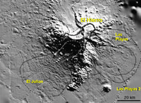
Giant landslides of El Hierro (M.Canals, 2003).
Advances in geophysics, Volume 47
By Renata Dmowska El Julian debris avalache
good page.
so we are talking about the El Julian debris avalanche area as regards this recent activity then
I opened the pdf of that page and took this larger image screenshot (lousey resolution)
Giant landslides of El Hierro (M.Canals, 2003).
Advances in geophysics, Volume 47
By Renata Dmowska El Julian debris avalache
edit on 28-9-2011 by muzzy because: (no reason given)
reply to post by muzzy
Thanks for doing that map.
I had not looked at the locations. Any thoughts on why it has moved off shore?
Thanks for doing that map.
I had not looked at the locations. Any thoughts on why it has moved off shore?
reply to post by PuterMan
no idea, if the earthquakes were shallower, say >1km it could have been a landslide in motion, but at 8-17km more likely a collaspe of a magma chamber roof, maybe
edit: wow I just broke that list down into individual csv files, I know you only mentioed quakes above Mag 2, but there were 91 today and 218 yesterday all up with the 1's in there
is this more than there was a few months back?
heres the same data broken down into individual kml files so that you can switch each day on and off to see the progress of the swarm of quakes down into the sea (well not really "into", as they are all below the crust anyway)
interactive Google Map E Hierro 18 to 28 Sept
maybe I should have counted forward from some point with the numbers on the icons, going backwards from today makes it harder to add more ( if there is more)
no idea, if the earthquakes were shallower, say >1km it could have been a landslide in motion, but at 8-17km more likely a collaspe of a magma chamber roof, maybe
edit on 28-9-2011 by muzzy because: (to add this)
edit: wow I just broke that list down into individual csv files, I know you only mentioed quakes above Mag 2, but there were 91 today and 218 yesterday all up with the 1's in there
is this more than there was a few months back?
edit on 28-9-2011 by muzzy because: (and this)
heres the same data broken down into individual kml files so that you can switch each day on and off to see the progress of the swarm of quakes down into the sea (well not really "into", as they are all below the crust anyway)
interactive Google Map E Hierro 18 to 28 Sept
maybe I should have counted forward from some point with the numbers on the icons, going backwards from today makes it harder to add more ( if there is more)
edit on 28-9-2011 by muzzy because: (no reason given)
further to post by muzzy
dam it, ran out of editing time
for those not familiar with Google Maps/KML file manipulation, what you do is, on the column at the left tick the box beside El Herro to activate all the files, then go down the list and click on the minus sign beside each days file to minimize the contents so you end up with a list of just 11 items. Then tick or untick the boxes as you please.
I start with all the 11 day list unticked and then tick each box progressively and you can see the direction the swarm is going
North and South but more so South last 2 days
I had a quick look on ATS and seen that this current swarm isn't too much to get excited about, compared to the
4200 in the last few weeks
Wasn't really watching.
I don't usually bother with one off threads about anything, they usually decend into talking about mega-tsunamis or Eleien or Haarp or such c_ap, so I hope my maps make a relevant contribution on VolcWatch
Back to NZ 's own dramas
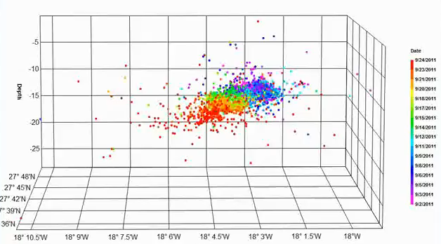
before I went and make a depth graph I thought I'd have a look around, nice colourful one here from Lurking on thinkbig
Wasn't really watching.
I don't usually bother with one off threads about anything, they usually decend into talking about mega-tsunamis or Eleien or Haarp or such c_ap, so I hope my maps make a relevant contribution on VolcWatch
Back to NZ 's own dramas
before I went and make a depth graph I thought I'd have a look around, nice colourful one here from Lurking on thinkbig
edit on 28-9-2011 by muzzy because: (no reason given)
4D Plots July through September. Quakes are shown with the island's topology for visual reference. Two rotations; one flat profile view, one
perspective view.
www.youtube.com...
screenshot
Awesome work
www.youtube.com...
screenshot
Awesome work
edit on 29-9-2011 by muzzy because: (no reason given)
Originally posted by muzzy
further to post by muzzy
North and South but more so South last 2 days
Can any . . . plausible inferences . . . at all
be made from those directional 'sweeps' of quake trends?
i.e.
What if such trends came in waves . . . North to South mostly or perhaps more severely in terms of magnitude . . .
That is as the quakes moved North to South, they got a bit more intense . . . or frequent . . .
Could any inferences be made about a directional weakening of the 'foundations' of the island in such directions?
reply to post by BO XIAN
I haven't studied the Canaries before yesterday but the most interesting thing I noticed on the pdf off mantleplumes.org (linked by ressiv at the top of this page) which on page 6 image 7 shows "future" development of Las Hijas seamount.
So perhaps rather than these earthquakes causing an eruption, this is more to do with a southerly progression of the Canary Hotspot towards Las Hijas.
All I know from experience of volcanos here in NZ, most recently the Mt Tihia swarm of 2009, where we had some 849 earthquakes in 6 weeks, swarms of earthquakes at volcanos don't always result in eruptions
edit on 29-9-2011 by muzzy because: (no reason given)
Los científicos consideran que en las próximas
horas se puede producir a un 99 %
Basically saying that scientists are saying that in the next few hours, an eruption at El Hierro will happen with a 99% probability...
We'll see.
Los científicos consideran que en las próximas horas se puede producir a un 99 %
Las mediciones y las previsiones de los científicos desplegados en la Isla de El Hierro y toda la estructura del IGN han señalado a las autoridades competentes dentro del Pevolca activado por el Gobierno de Canarias que la erupción volcánica que se espera hace días se puede producir en las próximas horas en un punto situado en el mar a doce kilómetros de distancia de las costas del suroeste de la isla y que corresponden al municipio de Frontera.
Basically saying that scientists are saying that in the next few hours, an eruption at El Hierro will happen with a 99% probability...
We'll see.
In the second line from the end doesn't it say about 12 kilometres from the coast , in the sea ? (basic spanish so apologies if wrong) that looks to
me what it says ...interesting ...a new island ?
edit on 29-9-2011 by slidingdoor because: (no reason given)
reply to post by slidingdoor
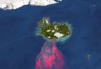
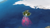
yep, looks like it on this recent map they put out (red dots), and deeper looking at the cross section below the map itself
www.ign.es...
the nearest submarine seamount is 1928m below seal level so it has a ways to go yet before it breaks the surface (if it does at all) 27.457582°, -17.997092° on GE or GMaps
yep, looks like it on this recent map they put out (red dots), and deeper looking at the cross section below the map itself
www.ign.es...
edit on 29-9-2011 by muzzy because: (no reason given)
the nearest submarine seamount is 1928m below seal level so it has a ways to go yet before it breaks the surface (if it does at all) 27.457582°, -17.997092° on GE or GMaps
edit on 29-9-2011 by muzzy because: (no reason given)
reply to post by muzzy
It's almost as if 'it' realised it couldn't pop up in the earlier swarm area due to land and migrated to a space that would allow it to ? Or would that be irrelevent given the forces of nature ?
It's almost as if 'it' realised it couldn't pop up in the earlier swarm area due to land and migrated to a space that would allow it to ? Or would that be irrelevent given the forces of nature ?
reply to post by slidingdoor
sure, the magma will look for the weakest point to break the crust, naturally at the undersea location the top of the crust will be closer to the magma. Not sure about an eruption though, the most recent quakes are going deeper.
But no one knows the contour of the underside of the crust there, maybe its thicker than in towards Hierro.
It will be interesting to see if the quakes keep going south and deeper or they hit some resistance of some kind and perhaps return towards the island and shallower, observation over the next 24hrs will tell.
I'm definitely going to make a GIF sequence of this, I just found the data going back 2 months (the fact that I can't read spanish doesn't help ) www.ign.es...
edit on 29-9-2011 by muzzy because: (no reason given)
reply to post by muzzy
Are we in Mid Atlantic ridge territory here or does it just miss it ?
Interesting analogy re the crust ... the exisiting Islands took a while to form , maybe this is just like a kick in the womb rather than full term !
P.S. I can try and help with the Spanish
Are we in Mid Atlantic ridge territory here or does it just miss it ?
Interesting analogy re the crust ... the exisiting Islands took a while to form , maybe this is just like a kick in the womb rather than full term !
P.S. I can try and help with the Spanish
edit on 29-9-2011 by slidingdoor because: (no reason given)
reply to post by muzzy
Ahhhh . . . thanks.
Do you have any distilled perceptions about swarms contributing to earth slides?
Above or under the water? Near or further from the plume?
Ahhhh . . . thanks.
Do you have any distilled perceptions about swarms contributing to earth slides?
Above or under the water? Near or further from the plume?
reply to post by BO XIAN
No I haven't really.
There was some concern during the Mt. Tihia swarm of there being a landslide at Waihi Village on the shores of Lake Taupo (of course Mt. Tihia is just a pimple on the crater of what was Taupo Volcano before it blew) as the area in the hills above the village are thermally active, but it came to nothing. Afterwards the authorities put out a warning to watch where you walked up there, due to possible new fractures in the ground.
A lot of landslide here in Fiordland, South island due to large earthquakes but not so much information about swarms of smaller quakes causing them.
new topics
-
University of Texas Instantly Shuts Down Anti Israel Protests
Education and Media: 27 minutes ago -
Any one suspicious of fever promotions events, major investor Goldman Sachs card only.
The Gray Area: 2 hours ago -
God's Righteousness is Greater than Our Wrath
Religion, Faith, And Theology: 7 hours ago -
Electrical tricks for saving money
Education and Media: 10 hours ago -
VP's Secret Service agent brawls with other agents at Andrews
Mainstream News: 11 hours ago
top topics
-
VP's Secret Service agent brawls with other agents at Andrews
Mainstream News: 11 hours ago, 9 flags -
Cats Used as Live Bait to Train Ferocious Pitbulls in Illegal NYC Dogfighting
Social Issues and Civil Unrest: 15 hours ago, 8 flags -
Nearly 70% Of Americans Want Talks To End War In Ukraine
Political Issues: 12 hours ago, 4 flags -
Electrical tricks for saving money
Education and Media: 10 hours ago, 4 flags -
Sunak spinning the sickness figures
Other Current Events: 12 hours ago, 3 flags -
Late Night with the Devil - a really good unusual modern horror film.
Movies: 14 hours ago, 2 flags -
Any one suspicious of fever promotions events, major investor Goldman Sachs card only.
The Gray Area: 2 hours ago, 2 flags -
The Good News According to Jesus - Episode 1
Religion, Faith, And Theology: 17 hours ago, 1 flags -
God's Righteousness is Greater than Our Wrath
Religion, Faith, And Theology: 7 hours ago, 0 flags -
University of Texas Instantly Shuts Down Anti Israel Protests
Education and Media: 27 minutes ago, 0 flags
active topics
-
God's Righteousness is Greater than Our Wrath
Religion, Faith, And Theology • 25 • : andy06shake -
Russia Ukraine Update Thread - part 3
World War Three • 5730 • : Arbitrageur -
Nearly 70% Of Americans Want Talks To End War In Ukraine
Political Issues • 28 • : andy06shake -
VP's Secret Service agent brawls with other agents at Andrews
Mainstream News • 43 • : Hakaiju -
Everest-sized ‘Devil comet’ Pons-Brooks Visible Now
Space Exploration • 17 • : Compendium -
Nakedeye Mother of Dragons Comet Is Here!
Space Exploration • 5 • : Compendium -
HORRIBLE !! Russian Soldier Drinking Own Urine To Survive In Battle
World War Three • 38 • : BernnieJGato -
15 Unhealthiest Sodas On The Market
Health & Wellness • 43 • : JPRCrastney -
University of Texas Instantly Shuts Down Anti Israel Protests
Education and Media • 0 • : FlyersFan -
Sunak spinning the sickness figures
Other Current Events • 9 • : Ohanka