It looks like you're using an Ad Blocker.
Please white-list or disable AboveTopSecret.com in your ad-blocking tool.
Thank you.
Some features of ATS will be disabled while you continue to use an ad-blocker.

The Chile Tsunami of 2010
page: 1share:
A Tsunami is an ocean wide event which dramatically demonstrates the energy released by a major earthquake. Here is an animation of the tsunami
produced by the Chile earthquake on February 27.
Seeing how the waves are reflected and refracted is amazing. The interference patterns are astounding. The entire Pacific basin is affected.
Kahului harbor on Maui continues to show the effects more than 72 hours later. The large steady sine wave is the normal tidal variation. The blue line is the predicted level and the red line is the recorded level. The green line represents the difference between the prediction and the actual. You can see when the tsunami first arrived at about 22:00 GMT on Saturday. The crest was about three feet above the tide level and the trough about 3 feet below. Where the red line is jagged (with a pretty constant period) it's showing the effects of the tsunami. It's easiest seen with the green line.
The whole ocean was humming a steady note for days, slowing getting quieter and quieter.
[atsimg]http://files.abovetopsecret.com/images/member/c4d677365759.png[/atsimg]
Here is a representation of the magnitude of the tsunami throughout the ocean. Notice how continental shorelines focus and amplify the waves.
[atsimg]http://files.abovetopsecret.com/images/member/3cc34a14f686.png[/atsimg]
While fortunately not destructive, the effects were clearly visible in parts of the Hawaiian Islands.
[edit on 3/3/2010 by Phage]
You know, even though the tsunami was "small", it's still impressive how powerful it is. You can't stop it like a "wave" - it's literally the
rising of the ocean - so much weight and power is behind it. It's also AMAZING that the CAUSE of tsunami we see in the Hawaii video came thousands
of miles away, some 16 hours BEFORE we see the change.
When I see this stuff, it makes me hope that the La Palma island never landslides into the sea, resulting in a mega tsunami which would eventually wipe out the eastern coast of the U.S. (amongst other places). I can't imagine how insane the evacuation would be. Hope I never live to see the day that happens.
When I see this stuff, it makes me hope that the La Palma island never landslides into the sea, resulting in a mega tsunami which would eventually wipe out the eastern coast of the U.S. (amongst other places). I can't imagine how insane the evacuation would be. Hope I never live to see the day that happens.
Thats awesome Phage. Just like a big bathtub
Lots of people at work here on Monday in New Zealand were totally rubbishing the Tsunami warnings, but I reckon we were actually quite lucky.
Idiots were actually turning up to the beaches just to see a glimpse of a huge wave!! Talk about lack of common sense!!
Things could have been much worse.
[edit on 3-3-2010 by grantbeed]
reply to post by grantbeed
My thought on people complaining about the tsunami warning is that they should thank their lucky stars and remember what happened in 2004. Is that what they want to see?
I'd rather have the scientists lean toward the overly concerned side than the negligent lack of warning side. That plus do those complainers have any idea of how to predict a tsunami? Fools with short memories.
reply to post by harrytuttle
I agree. The warnings have to be issued. Imagine if there was no severe warnings and a huge wave hit. It would be terrible.
Between Chile and New Zealand, there are very few indicators as to how big the waves are getting.
We were using the Chatham Islands as a guide to Wave size and they are only 500 miles (800km) away. That does'nt give people much time to prepare when you consider the speed Tsunamis can travel.
www.gns.cri.nz...
I agree. The warnings have to be issued. Imagine if there was no severe warnings and a huge wave hit. It would be terrible.
Between Chile and New Zealand, there are very few indicators as to how big the waves are getting.
We were using the Chatham Islands as a guide to Wave size and they are only 500 miles (800km) away. That does'nt give people much time to prepare when you consider the speed Tsunamis can travel.
In the open ocean, tsunami waves travel at 600kph to 700kph. In the deep ocean, waves from a large tsunami may be as little as 60cm high. They pass ships unnoticed. As they encounter shallow water, they slow down to about 30kph and increase in height
www.gns.cri.nz...
reply to post by grantbeed
6,600 miles from Constitucion to Hilo. 15 hours. 440 mph. Comparable to a passenger jet.
6,600 miles from Constitucion to Hilo. 15 hours. 440 mph. Comparable to a passenger jet.
When these warnings were issued I was concerned. Didn't want to see Vancouver Int'l go underwater 2 days before the World has to leave.
It's only about 20' MSL.
I would rather they played it extremely cautious than be too laissez-faire and kill 1000's of people. These things can ruin your day very quickly.
I would rather they played it extremely cautious than be too laissez-faire and kill 1000's of people. These things can ruin your day very quickly.
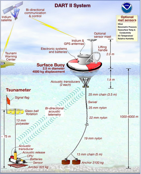
Phage, do you know what method the detection buoys use to determine the difference between regular wave activity and a tsunami?
reply to post by dainoyfb
Very cool stuff. It's actually two separate systems. The sensors for weather buoys are located on the buoy at the surface of the ocean. They are able to record the amplitude of short, wind driven waves by sensing the rise and drop as the wave passes by.
The amplitude of tsunami waves is too slight and the wavelength too long for this to work. For them the sensor is set on the sea floor, the buoy itself acting as a station for the satellite transmitter which sends the data. The sensor detects the changes in water pressure as the tsunami passes. Interestingly, the sensors also detect the earthquake itself, the lifting of the ocean bottom causing an increase in water pressure.
Nice Phage. Though I did not read the thread about the Japanese apologizing for the Tsunami warning. I feel the apology was uncalled for. Obviously
the science is not up to speed to predict the size of these things. I hope people do not think they were crying wolf.
The power of nature is an awesome thing.
Thanks for the fantastic thread.
The power of nature is an awesome thing.
Thanks for the fantastic thread.
You always post your facts, Phage...much appreciated!
makes things much easier to understand.
[edit on 3-3-2010 by ghr54321]
makes things much easier to understand.
[edit on 3-3-2010 by ghr54321]
reply to post by Phage
Ok, that makes sense. I thought maybe they had a way to deal directly with the difficult S/N ratio on the surface.
Ok, that makes sense. I thought maybe they had a way to deal directly with the difficult S/N ratio on the surface.
Originally posted by Phage
reply to post by grantbeed
6,600 miles from Constitucion to Hilo. 15 hours. 440 mph. Comparable to a passenger jet.
What I found interesting was according to that model at approx 44 seconds on the video the tsunami now nearly mid pacific causes backward ripples (waves) that head back to Chile. I wonder how large they were. And rather like a bathtub the water sloshes back and forth in the tsunami's wake for hours after.
reply to post by tarifa37
That can be seen in the water level chart from Maui.
(Maybe I should have explained that a bit more for the less nautically aware).
First, the large steady sine wave is the normal tidal variation. The blue line is the predicted level and the red line is the recorded level. The green line represents the difference between the prediction and the actual. You can see when the tsunami first arrived at about 22:00 GMT on Saturday. The crest was about three feet above the tide level and the trough about 3 feet below. Where the red line is jagged (with a pretty constant period) it's showing the effects of the tsunami. It's easiest seen with the green line.
The whole ocean was humming a steady note for days, slowing getting quieter and quieter.
In this very interesting scene from National Geographic, here's what a huge tsunami would look like in the scenario of a massive landslide from a
Mauna Loa volcano eruption:
I thought it was curious they said the wave would only have a speed of about 43 miles per hour on impact, compared with the near supersonic speed they can travel in open ocean.
I thought it was curious they said the wave would only have a speed of about 43 miles per hour on impact, compared with the near supersonic speed they can travel in open ocean.
reply to post by TrueAmerican
Wow, great thread. The speed of the wave slows down as it hits shallower water, as it slows it builds the wave higher.
My question is this: Why are there multiple waves instead of one? Are these secondary waves refracted from the coastlines where the intial wave has previously struck?
I love to laugh at the idiots that will stand there with a camera trying to record the tsunami. The thing is, were I there I would be one of those same idiots. When nature is at work I just gotta see what happens.
Originally posted by Asktheanimals
reply to post by TrueAmerican
My question is this: Why are there multiple waves instead of one? Are these secondary waves refracted from the coastlines where the intial wave has previously struck?
That could partly be the reason in some cases, but my best guess would be that a thrust event, or earthquake actually occurs in multiple, smaller stages. Quickly, yes, but at each stage of displacement a new wave is created.
Nice Find Phage, thanks for posting, it shows even the smallest Tsunami's can have an affect on Tidal rivers as seen in the video.
What I am trying to find though is any pictures or video clips of the Tsunami that hit Chile, from the reports I have seen, it seemed to be alot more destructive on the coast of Chile.
What I am trying to find though is any pictures or video clips of the Tsunami that hit Chile, from the reports I have seen, it seemed to be alot more destructive on the coast of Chile.
ive surfed on waves 25 foot and its scary as hell, let me tell you, i can only imagine what a 50-75ft tsunami must be like
Originally posted by Sparkey76
What I am trying to find though is any pictures or video clips of the Tsunami that hit Chile, from the reports I have seen, it seemed to be alot more destructive on the coast of Chile.
Funny, I just posted a whole thread of them right here:
www.abovetopsecret.com...
new topics
-
Sunak spinning the sickness figures
Other Current Events: 37 minutes ago -
Nearly 70% Of Americans Want Talks To End War In Ukraine
Political Issues: 48 minutes ago -
Late Night with the Devil - a really good unusual modern horror film.
Movies: 2 hours ago -
Cats Used as Live Bait to Train Ferocious Pitbulls in Illegal NYC Dogfighting
Social Issues and Civil Unrest: 3 hours ago -
The Good News According to Jesus - Episode 1
Religion, Faith, And Theology: 5 hours ago -
HORRIBLE !! Russian Soldier Drinking Own Urine To Survive In Battle
World War Three: 8 hours ago -
Bobiverse
Fantasy & Science Fiction: 10 hours ago -
Florida man's trip overseas ends in shock over $143,000 T-Mobile phone bill
Social Issues and Civil Unrest: 10 hours ago
top topics
-
Florida man's trip overseas ends in shock over $143,000 T-Mobile phone bill
Social Issues and Civil Unrest: 10 hours ago, 8 flags -
SETI chief says US has no evidence for alien technology. 'And we never have'
Aliens and UFOs: 14 hours ago, 7 flags -
Cats Used as Live Bait to Train Ferocious Pitbulls in Illegal NYC Dogfighting
Social Issues and Civil Unrest: 3 hours ago, 7 flags -
This is our Story
General Entertainment: 17 hours ago, 4 flags -
Former Labour minister Frank Field dies aged 81
People: 13 hours ago, 4 flags -
Bobiverse
Fantasy & Science Fiction: 10 hours ago, 3 flags -
Late Night with the Devil - a really good unusual modern horror film.
Movies: 2 hours ago, 2 flags -
HORRIBLE !! Russian Soldier Drinking Own Urine To Survive In Battle
World War Three: 8 hours ago, 2 flags -
The Good News According to Jesus - Episode 1
Religion, Faith, And Theology: 5 hours ago, 0 flags -
Nearly 70% Of Americans Want Talks To End War In Ukraine
Political Issues: 48 minutes ago, 0 flags
active topics
-
Nearly 70% Of Americans Want Talks To End War In Ukraine
Political Issues • 4 • : budzprime69 -
President BIDEN Vows to Make Americans Pay More Federal Taxes in 2025 - Political Suicide.
2024 Elections • 114 • : ImagoDei -
HORRIBLE !! Russian Soldier Drinking Own Urine To Survive In Battle
World War Three • 24 • : budzprime69 -
Breaking Baltimore, ship brings down bridge, mass casualties
Other Current Events • 482 • : IndieA -
How ageing is" immune deficiency"
Medical Issues & Conspiracies • 30 • : annonentity -
Remember These Attacks When President Trump 2.0 Retribution-Justice Commences.
2024 Elections • 55 • : Zanti Misfit -
SETI chief says US has no evidence for alien technology. 'And we never have'
Aliens and UFOs • 36 • : anthelion -
Truth Social goes public, be careful not to lose your money
Mainstream News • 124 • : lilzazz -
British TV Presenter Refuses To Use Guest's Preferred Pronouns
Education and Media • 145 • : Annee -
Sunak spinning the sickness figures
Other Current Events • 0 • : annonentity