It looks like you're using an Ad Blocker.
Please white-list or disable AboveTopSecret.com in your ad-blocking tool.
Thank you.
Some features of ATS will be disabled while you continue to use an ad-blocker.

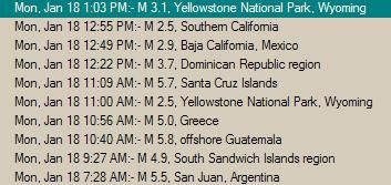
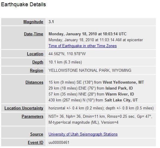
Magnitude 2.7 - YELLOWSTONE NATIONAL PARK, WYOMING
page: 2share:
according to GLP (say what you want but they is always constant coverage of breaking topics, they get a lot more traffic I think than ATS) but it
seems there has been some data manipulation/deletion from the usgs site...
unless its a sign of increasing caldera activity, keep an open mind because it will happen eventually.
0.8 2010/01/17 19:50:19 44.565N 110.966W 9.4 15 km (10 mi) SE of West Yellowstone, MT
2.5 2010/01/17 19:44:15 44.569N 111.011W 14.8 13 km ( 8 mi) SE of West Yellowstone, MT
2.7 2010/01/17 19:38:01 44.561N 110.973W 9.8 15 km (10 mi) SE of West Yellowstone, MT
2.6 2010/01/17 18:04:24 44.562N 110.972W 9.0 15 km (10 mi) SE of West Yellowstone, MT
2.7 2010/01/17 17:02:56 44.563N 110.970W 11.3 15 km (10 mi) SE of West Yellowstone, MT
2.5 2010/01/17 15:43:34 44.565N 110.972W 6.5 15 km ( 9 mi) SE of West Yellowstone, MT
2.6 2010/01/17 14:55:56 44.554N 110.970W 0.9 16 km (10 mi) SE of West Yellowstone, MT
2.7 2010/01/17 14:04:07 44.562N 110.967W 9.7 16 km (10 mi) SE of West Yellowstone, MT
1.5 2010/01/15 02:11:34 44.574N 110.927W 4.5 17 km (11 mi) SE of West Yellowstone, MT
0.4 2010/01/13 10:14:00 44.332N 110.464W 6.8 63 km (39 mi) SE of West Yellowstone, MT
0.1 2010/01/13 10:11:07 44.332N 110.456W 4.0 63 km (39 mi) SE of West Yellowstone, MT
1.0 2010/01/13 10:10:37 44.330N 110.464W 7.0 63 km (39 mi) SE of West Yellowstone, MT
0.3 2010/01/12 03:55:21 44.752N 111.334W 1.8 21 km (13 mi) WNW of West Yellowstone, MT
0.3 2010/01/11 15:50:21 44.746N 111.162W 3.0 10 km ( 6 mi) NNW of West Yellowstone, MT
It's definatley worth a post. there seems to be a swarm of half decent size quakes happening here just now.
will be interesting to keep an eye on over the next few days.
www.seis.utah.edu...
S&F.
reply to post by dgtempe
DG, You are from the east coast, so maybe the san andreas means little to you, but it is as famous a name as san francisco, we wouldn't call frisco Saint francisco.
DG, You are from the east coast, so maybe the san andreas means little to you, but it is as famous a name as san francisco, we wouldn't call frisco Saint francisco.
I watched something on the nationial geographic channel a month ago, there is some kind if moving larver flow under yellow stone building up pressure
and exploding with devistating force. yellow stone was the last location this happened, im pretty sure it hapened about 600k years ago and its over
due an erruption.im not very technical but i know whats going on, very intersting place i think they should get down there and get studying and
predict a year!
Originally posted by Alethea
Can anyone post some of the other sites that give real time info rather than just USGS?
Do we know any alternative sites outside the USA?
Also can anyone post sites that show tsunami registers?
Thanks
Thsi might help:
CLICK HERE
Originally posted by SunnyDee
reply to post by Donny 4 million
I think you meant SAN Andreas not St. No offense, just a bit odd to get that wrong if you study our very big fault line.
Sure no offense taken. I suffer from a crack or two myself.
It is not so much studding the fault as it is the petroglyphs on the walls of the shears. Out past Rainbow Basin. Have you been there?
Try it you will like it.
Thanks for keeping me aware of the onset of old age and my impetuousness. Just make it the last time. LOL
Originally posted by dgtempe
reply to post by SunnyDee
FYI:
ST. and San mean the same thing.(English & Spanish)
Can we just stick with the thread, and yes, i moonlight as a rent a cop.
It is all good dgt
Those hardy Californian's are proud of their cracks and should be.
Understanding the difference between the many types of earthly pimples and wrinkles is what it is all about.
I lived at Chatham for two years. 42 years ago. The only cracks were in the clams, oysters and scallops when I shucked them, yum!
Send me some.
I get all my data from www.iris.edu...
There are may big quakes the last days....
NEW ONE: NEAR COAST OF GUATEMALA
18-JAN-2010 15:40:32
13.81 -90.20
MAG 5.8
DEEP 103.3
Parts of "El Salvadors" seems to be damaged....
Source (german, ch):
www.nzz.ch...
There are may big quakes the last days....
NEW ONE: NEAR COAST OF GUATEMALA
18-JAN-2010 15:40:32
13.81 -90.20
MAG 5.8
DEEP 103.3
Parts of "El Salvadors" seems to be damaged....
Source (german, ch):
www.nzz.ch...
reply to post by Donny 4 million
I would love to. I am into fishing and crabbing (suitable) It is beautiful. I'm in Marstons Mills, a Millbilly.
I would love to. I am into fishing and crabbing (suitable) It is beautiful. I'm in Marstons Mills, a Millbilly.
reply to post by Dramey
normally i would totally agree, but have you ever seen mt saint helens? it BLEW IT'S TOP. literally. a MOUNTAIN. and if the yellowstone caldera goes, it'll make it look like a firecracker.
www.youtube.com...
Goodbye america, mexico, and southern canada.
BANG.
do you see what i mean?
normally i would totally agree, but have you ever seen mt saint helens? it BLEW IT'S TOP. literally. a MOUNTAIN. and if the yellowstone caldera goes, it'll make it look like a firecracker.
www.youtube.com...
Goodbye america, mexico, and southern canada.
BANG.
do you see what i mean?
reply to post by dgtempe
The entire National Park is ringed by the caldera, 2.2 million acres.
Molten rock from 125 miles below the surface.
The equivalent of the size of Rhode Island and 8 miles high.
Loaded with TNT.
No wonder the ranchers sold it to the government.
more to come.
My true love was from Harwichport.
[edit on 18-1-2010 by Donny 4 million]
reply to post by cushycrux
Thats a cool site. There used to be so much more especially government sites but after 911 alot of that went away.
thanks
Thats a cool site. There used to be so much more especially government sites but after 911 alot of that went away.
thanks
I don't know enough about geology but couldn't they do a simple thing like, drill a relief hole to vent the pressure, rather than wait for it to
build to devastating events? I'd imagine that would be a much smaller and manageable eruption than waiting for the the top to blow off... like
lancing a cyst...
Originally posted by Forty6and2
I don't know enough about geology but couldn't they do a simple thing like, drill a relief hole to vent the pressure, rather than wait for it to build to devastating events? I'd imagine that would be a much smaller and manageable eruption than waiting for the the top to blow off... like lancing a cyst...
There are a lot of them that occur naturally.
Most famous Old Faithful.
Well ok but just try to imagine lancing that 2.2 million acre cyst.
Even if you teamed up- The Jolly Green Giant, Shack, Paul Bunyon and
The Blue Ox they would be splattered all over the mirror as soon as that pimple popped.
All green, black and blue. Yikes!
reply to post by Forty6and2
The pressure from the pool of magma (lava) under Yellowstone has lifted it and surrounding areas some 1,700 feet higher than it would normally be.
A safe distance during an eruption would be about a thousand miles.
I would think further if you were down wind.
I hope the attention given this caldera doesn't depress the local real estate .
hi all.
the discovery channel once made a "made for tv" short film about the yellowstone erupting.
good old youtube.
you can watch it here, the end of the world!!
www.youtube.com...
freestone
the discovery channel once made a "made for tv" short film about the yellowstone erupting.
good old youtube.
you can watch it here, the end of the world!!
www.youtube.com...
freestone
new topics
-
George Knapp AMA on DI
Area 51 and other Facilities: 4 hours ago -
Not Aliens but a Nazi Occult Inspired and then Science Rendered Design.
Aliens and UFOs: 4 hours ago -
Louisiana Lawmakers Seek to Limit Public Access to Government Records
Political Issues: 6 hours ago -
The Tories may be wiped out after the Election - Serves them Right
Regional Politics: 7 hours ago -
So I saw about 30 UFOs in formation last night.
Aliens and UFOs: 9 hours ago -
Do we live in a simulation similar to The Matrix 1999?
ATS Skunk Works: 10 hours ago -
BREAKING: O’Keefe Media Uncovers who is really running the White House
US Political Madness: 11 hours ago
top topics
-
BREAKING: O’Keefe Media Uncovers who is really running the White House
US Political Madness: 11 hours ago, 23 flags -
George Knapp AMA on DI
Area 51 and other Facilities: 4 hours ago, 18 flags -
Biden--My Uncle Was Eaten By Cannibals
US Political Madness: 12 hours ago, 18 flags -
African "Newcomers" Tell NYC They Don't Like the Free Food or Shelter They've Been Given
Social Issues and Civil Unrest: 17 hours ago, 12 flags -
"We're All Hamas" Heard at Columbia University Protests
Social Issues and Civil Unrest: 12 hours ago, 7 flags -
Louisiana Lawmakers Seek to Limit Public Access to Government Records
Political Issues: 6 hours ago, 7 flags -
Russian intelligence officer: explosions at defense factories in the USA and Wales may be sabotage
Weaponry: 16 hours ago, 6 flags -
So I saw about 30 UFOs in formation last night.
Aliens and UFOs: 9 hours ago, 5 flags -
The Tories may be wiped out after the Election - Serves them Right
Regional Politics: 7 hours ago, 3 flags -
Not Aliens but a Nazi Occult Inspired and then Science Rendered Design.
Aliens and UFOs: 4 hours ago, 3 flags
active topics
-
George Knapp AMA on DI
Area 51 and other Facilities • 13 • : DumbNut -
Candidate TRUMP Now Has Crazy Judge JUAN MERCHAN After Him - The Stormy Daniels Hush-Money Case.
Political Conspiracies • 381 • : xuenchen -
Biden--My Uncle Was Eaten By Cannibals
US Political Madness • 43 • : DBCowboy -
OUT OF THE BLUE Chilling moment pulsating blue cigar-shaped UFO is filmed hovering over PHX AZ
Aliens and UFOs • 41 • : DaydreamerX -
-@TH3WH17ERABB17- -Q- ---TIME TO SHOW THE WORLD--- -Part- --44--
Dissecting Disinformation • 531 • : cherokeetroy -
So I saw about 30 UFOs in formation last night.
Aliens and UFOs • 20 • : Halfswede -
MULTIPLE SKYMASTER MESSAGES GOING OUT
World War Three • 33 • : Halfswede -
Not Aliens but a Nazi Occult Inspired and then Science Rendered Design.
Aliens and UFOs • 7 • : JonnyC555 -
Mood Music Part VI
Music • 3057 • : BatCaveJoe -
The Tories may be wiped out after the Election - Serves them Right
Regional Politics • 19 • : alwaysbeenhere2