It looks like you're using an Ad Blocker.
Please white-list or disable AboveTopSecret.com in your ad-blocking tool.
Thank you.
Some features of ATS will be disabled while you continue to use an ad-blocker.

Quake Watch 2010
page: 3share:
Another pretty decent sized earthquake here near Milpitas and Fremont CA. Waiting for USGS to update their numbers. My dogs are going nuts!
[edit on 8-1-2010 by FoundClarity]
[edit on 8-1-2010 by FoundClarity]
Here's the report:
3.8 2010/01/08 11:48:50 37.478N 121.794W 8.1 10 km ( 6 mi) ENE of Milpitas, CA
Same place as yesterday and just a wee bit smaller.
3.8 2010/01/08 11:48:50 37.478N 121.794W 8.1 10 km ( 6 mi) ENE of Milpitas, CA
Same place as yesterday and just a wee bit smaller.
Series of 2.x quakes after:
2.4 2010/01/08 12:36:14 38.408N 122.666W 8.8 6 km ( 3 mi) SE of Santa Rosa, CA
2.5 2010/01/08 12:35:18 38.410N 122.664W 8.7 6 km ( 3 mi) SE of Santa Rosa, CA
2.2 2010/01/08 12:15:33 37.386N 118.830W 10.7 21 km (13 mi) W of Round Valley, CA
I don't make predictions but this is definitely interesting. Take a look at the Cali map:
quake.usgs.gov...
The Round Valley one makes it on to the Long Valley caldera map. (Though just barely)
Another big one in the Solomon Islands
6.3 2010/01/09 05:51:34 -9.169 157.614 35.0 SOLOMON ISLANDS
And earlier
5.0 2010/01/09 04:00:51 12.100 142.047 63.9 MARIANA ISLANDS REGION
Edited to add
and later....
5.4 2010/01/09 07:04:36 -9.150 157.645 35.0 SOLOMON ISLANDS
[edit on 9-1-2010 by quakewatcher]
6.3 2010/01/09 05:51:34 -9.169 157.614 35.0 SOLOMON ISLANDS
And earlier
5.0 2010/01/09 04:00:51 12.100 142.047 63.9 MARIANA ISLANDS REGION
Edited to add
and later....
5.4 2010/01/09 07:04:36 -9.150 157.645 35.0 SOLOMON ISLANDS
[edit on 9-1-2010 by quakewatcher]
Twitter report of an earthquake in Ulaanbaatar Mongolia (Capital city of Mongolia)
Who knows if it'll ever show up on the USGS map, probably not if it's not large enough. But it's kind of wild how easy it is to get reports worldwide this way now.
Who knows if it'll ever show up on the USGS map, probably not if it's not large enough. But it's kind of wild how easy it is to get reports worldwide this way now.
It seems like this thread is better served if it just tracks some of the bigger swarms or bigger quakes and not every quake there is. Just my .02
cents after inflation, I'm not trying to take away from anyone's hard work.
Watcher are you also HX3?
[edit on 9-1-2010 by whoshotJR]
Watcher are you also HX3?
[edit on 9-1-2010 by whoshotJR]
I am only mentioning a very small fraction. For example, there are 688 earthquakes currently on the California map alone.
I'm trying to keep it to Mag 4.5 + and one/two posts a day w/ a list unless it's part of a cluster I'm watching. I'd really rather not start another thread about the West Coast of the US (smaller quakes I'm following) since it's much easier to follow from the start. If people would rather I stop I don't have to post here.
I'd prefer to just go back in and edit posts to add to existing lists but can't after the calendar day ends. I'll try to wait until morning local time so I don't end up with two posts for the same day, UTC.
...and I can't help it, I'm intrigued by Twitter earthquake reports (and so is the USGS) for example, there was just an earthquake in Japan about 2 minutes ago, strong enough to wake people up and send them to Twitter. Makes me want to jump on here every time and squeee about it.
[edit on 9-1-2010 by quakewatcher]
I knew there would be a decent one on the west coast eventually with everything popping off. I hope its done but I just have a gut feeling its not.
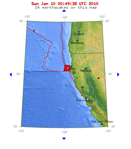
Earthquake Details
Magnitude 6.5
Date-Time
* Sunday, January 10, 2010 at 00:27:39 UTC
* Saturday, January 09, 2010 at 04:27:39 PM at epicenter
Location 40.674°N, 124.655°W
Depth 16.4 km (10.2 miles)
Region OFFSHORE NORTHERN CALIFORNIA
Distances
* 35 km (22 miles) WNW (288°) from Ferndale, CA
* 39 km (24 miles) W (261°) from Humboldt Hill, CA
* 41 km (26 miles) WSW (256°) from Bayview, CA
* 43 km (27 miles) WSW (253°) from Eureka, CA
* 361 km (224 miles) NW (312°) from Sacramento, CA
Location Uncertainty horizontal +/- 0.7 km (0.4 miles); depth +/- 1.1 km (0.7 miles)
Parameters Nph= 99, Dmin=35 km, Rmss=0.36 sec, Gp=212°,
M-type=regional moment magnitude (Mw), Version=3
[edit on 9-1-2010 by whoshotJR]
It was followed by a 2.7 so that should be a good thing for CA people. Normally that means it wasn't a precursor to a bigger one in the near future.
I am not any other user name. Just quakewatcher. I hope that was all the CA action was about, so far reports of injuries but no fatalities. Could
have been much worse.
Hmmm...2 Mi's closer to the surface than the 6.5M...
A light earthquake occurred at 6:21:38 PM (PST) on Saturday, January 9, 2010.
The magnitude 4.5 event occurred 43 km (27 miles) W of Ferndale, CA.
The hypocentral depth is 13 km ( 8 miles).
Magnitude 4.5 - local magnitude (ML)
Time Saturday, January 9, 2010 at 6:21:38 PM (PST)
Sunday, January 10, 2010 at 2:21:38 (UTC)
Distance from Ferndale, CA - 43 km (27 miles) W (276 degrees)
Humboldt Hill, CA - 49 km (31 miles) WSW (255 degrees)
Petrolia, CA - 52 km (32 miles) NW (309 degrees)
Eureka, CA - 54 km (34 miles) WSW (250 degrees)
Sacramento, CA - 364 km (226 miles) NW (310 degrees)
Coordinates 40 deg. 37.1 min. N (40.618N), 124 deg. 46.0 min. W (124.767W)
Depth 13.3 km (8.3 miles)
(P.S.: I'm me! )
[edit on 1/9/2010 by Hx3_1963]
I found a few documents from FEMA regarding Earthquake drills. For 2009, 2010, 2011 and 2012.
Check them out here:
ATS Thread
Check them out here:
ATS Thread
Aftershocks so far:
Most Recent:
4.0 2010/01/09 22:32:17 40.311N 124.573W 18.9 24 km (15 mi) W of Petrolia, CA
Edited to add more, 10:21 pm PST
2.9 2010/01/09 22:04:17 40.707N 124.533W 14.4 27 km (17 mi) WNW of Ferndale, CA
2.3 2010/01/09 21:16:13 40.704N 124.528W 16.7 26 km (16 mi) WNW of Ferndale, CA
2.8 2010/01/09 20:55:15 40.436N 124.862W 17.1 50 km (31 mi) WNW of Petrolia, CA
3.0* 2010/01/09 20:31:36 40.484N 124.693W 23.9 38 km (24 mi) WSW of Ferndale, CA
* revised down from 3.4
Edited to add more, 8:44 pm PST
3.4* 2010/01/09 20:31:35 40.513N 124.707W 12.5 38 km (24 mi) W of Ferndale, CA
* later revised down to 3.0
2.8 2010/01/09 19:42:58 40.566N 124.883W 19.1 52 km (33 mi) W of Ferndale, CA
2.6 2010/01/09 19:40:18 40.559N 124.896W 19.9 53 km (33 mi) W of Ferndale, CA
Edited to add more, 7:17 PST:
2.9 2010/01/09 19:10:46 40.728N 124.425W 16.7 19 km (12 mi) W of Humboldt Hill, CA
4.2 2010/01/09 19:07:00 40.653N 124.704W 8.6 38 km (24 mi) WNW of Ferndale, CA
...before...
3.0 2010/01/09 18:32:48 40.355N 124.740W 18.1 39 km (24 mi) W of Petrolia, CA
4.5 2010/01/09 18:21:38 40.618N 124.767W 13.3 43 km (27 mi) W of Ferndale, CA
3.0 2010/01/09 17:48:46 40.696N 124.590W 10.9 31 km (19 mi) WNW of Ferndale, CA
3.6 2010/01/09 17:06:15 40.605N 124.773W 8.8 43 km (27 mi) W of Ferndale, CA
3.5 2010/01/09 16:50:58 40.675N 124.671W 6.3 36 km (22 mi) WNW of Ferndale, CA
3.8 2010/01/09 16:48:37 40.691N 124.585W 12.9 30 km (19 mi) WNW of Ferndale, CA
3.6 2010/01/09 16:42:38 40.428N 124.829W 18.3 48 km (30 mi) WNW of Petrolia, CA
And just a few minutes ago in Eastern CA a very shallow 3.1
3.1 - local magnitude (ML)
Time Saturday, January 9, 2010 at 6:55:05 PM (PST)
Sunday, January 10, 2010 at 2:55:05 (UTC)
Distance from Keeler, CA - 10 km (6 miles) S (180 degrees)
Cartago, CA - 16 km (10 miles) ENE (57 degrees)
Olancha, CA - 19 km (12 miles) NE (36 degrees)
Lone Pine, CA - 27 km (17 miles) SE (139 degrees)
Las Vegas, NV - 239 km (148 miles) W (276 degrees)
Coordinates 36 deg. 24.0 min. N (36.400N), 117 deg. 52.4 min. W (117.873W)
Depth 0.6 km (0.4 miles)
Location Quality Fair
Location Quality Parameters Nst=033, Nph=033, Dmin=18 km, Rmss=0.27 sec, Erho=0.5 km, Erzz=1.6 km, Gp=79.2 degrees
Event ID# ci14570732
Watching and wondering if those patterns of 2.x quakes are going to turn into patterns of 3.x quakes... or I am just spooked and have been following this for too long.
[edit on 9-1-2010 by quakewatcher]
[edit on 9-1-2010 by quakewatcher]
[edit on 10-1-2010 by quakewatcher]
[edit on 10-1-2010 by quakewatcher]
Might want to keep an eye on the Keeler area now as well...
I've noticed this area is at the intersection of a couple of nice faults...
I'm wondering if that 3.3M off Oregon yesterday transferred some energy down stream...Hmmm...
Hmmm...getting closer to the surface...
A light earthquake occurred at 7:07:00 PM (PST) on Saturday, January 9, 2010.
The magnitude 4.2 event occurred 38 km (24 miles) WNW of Ferndale, CA.
The hypocentral depth is 9 km ( 5 miles).
earthquake.usgs.gov...
Magnitude 4.2 - regional moment magnitude (Mw)
Time Saturday, January 9, 2010 at 7:07:00 PM (PST)
Sunday, January 10, 2010 at 3:07:00 (UTC)
Distance from Ferndale, CA - 38 km (24 miles) WNW (283 degrees)
Humboldt Hill, CA - 43 km (27 miles) WSW (258 degrees)
Bayview, CA - 46 km (29 miles) WSW (254 degrees)
Eureka, CA - 48 km (30 miles) WSW (252 degrees)
Sacramento, CA - 362 km (225 miles) NW (311 degrees)
Coordinates 40 deg. 39.2 min. N (40.653N), 124 deg. 42.2 min. W (124.704W)
Depth 8.6 km (5.3 miles)
[edit on 1/9/2010 by Hx3_1963]
Two earthquakes of struck within minutes of each other on both sides of the Pacific Ocean Saturday night according to reports released by the US
Geological Survey (USGS). One quake of magnitude 6.5 was centered about 43 miles away from Ferndale, California, while the other was weaker at
magnitude 5.0 and was centered just offshore of the island of Java approximately 60 miles from the city of Tasikmalaya, Java, says the US Geological
Survey report.
www.associatedcontent.com...
www.associatedcontent.com...
At it again in Baja:
4.1 - local magnitude (ML)
Time Saturday, January 9, 2010 at 10:35:53 PM (PST)
Sunday, January 10, 2010 at 6:35:53 (UTC)
Distance from Guadalupe Victoria, Baja California, Mexico - 13 km (8 miles) NNW (341 degrees)
San Luis Río Colorado, Sonora, Mexico - 36 km (23 miles) W (260 degrees)
San Luis, AZ - 38 km (24 miles) WSW (254 degrees)
Gadsden, AZ - 39 km (24 miles) WSW (244 degrees)
Tijuana, Baja California, Mexico - 175 km (109 miles) E (94 degrees)
Coordinates 32 deg. 24.2 min. N (32.404N), 115 deg. 9.4 min. W (115.157W)
Depth 32.6 km (20.3 miles)
Location Quality Fair
Location Quality Parameters Nst=030, Nph=030, Dmin=41 km, Rmss=0.26 sec, Erho=1.4 km, Erzz=4.6 km, Gp=212.4 degrees
Event ID# ci14570852
Now there's major activity North and South in CA. It's an interesting week.
By the way, this was three minutes after the last 4.0 aftershock in the North.
[edit on 10-1-2010 by quakewatcher]
new topics
-
Comparing the theology of Paul and Hebrews
Religion, Faith, And Theology: 10 minutes ago -
Pentagon acknowledges secret UFO project, the Kona Blue program | Vargas Reports
Aliens and UFOs: 1 hours ago -
Boston Dynamics say Farewell to Atlas
Science & Technology: 1 hours ago -
I hate dreaming
Rant: 1 hours ago -
Is the origin for the Eye of Horus the pineal gland?
Philosophy and Metaphysics: 3 hours ago -
Man sets himself on fire outside Donald Trump trial
Mainstream News: 3 hours ago -
Biden says little kids flip him the bird all the time.
2024 Elections: 4 hours ago -
The Democrats Take Control the House - Look what happened while you were sleeping
US Political Madness: 4 hours ago -
Sheetz facing racial discrimination lawsuit for considering criminal history in hiring
Social Issues and Civil Unrest: 4 hours ago -
In an Historic First, In N Out Burger Permanently Closes a Location
Mainstream News: 6 hours ago
top topics
-
In an Historic First, In N Out Burger Permanently Closes a Location
Mainstream News: 6 hours ago, 14 flags -
The Democrats Take Control the House - Look what happened while you were sleeping
US Political Madness: 4 hours ago, 11 flags -
Thousands Of Young Ukrainian Men Trying To Flee The Country To Avoid Conscription And The War
Other Current Events: 17 hours ago, 8 flags -
A man of the people
Medical Issues & Conspiracies: 11 hours ago, 8 flags -
Man sets himself on fire outside Donald Trump trial
Mainstream News: 3 hours ago, 7 flags -
Biden says little kids flip him the bird all the time.
2024 Elections: 4 hours ago, 6 flags -
4 plans of US elites to defeat Russia
New World Order: 13 hours ago, 4 flags -
Pentagon acknowledges secret UFO project, the Kona Blue program | Vargas Reports
Aliens and UFOs: 1 hours ago, 4 flags -
Is the origin for the Eye of Horus the pineal gland?
Philosophy and Metaphysics: 3 hours ago, 4 flags -
Sheetz facing racial discrimination lawsuit for considering criminal history in hiring
Social Issues and Civil Unrest: 4 hours ago, 3 flags
active topics
-
A man of the people
Medical Issues & Conspiracies • 9 • : tarantulabite1 -
Silent Moments --In Memory of Beloved Member TDDA
Short Stories • 47 • : Naftalin -
Thousands Of Young Ukrainian Men Trying To Flee The Country To Avoid Conscription And The War
Other Current Events • 38 • : DBCowboy -
George Knapp AMA on DI
Area 51 and other Facilities • 28 • : theshadowknows -
Pentagon acknowledges secret UFO project, the Kona Blue program | Vargas Reports
Aliens and UFOs • 4 • : Ophiuchus1 -
Comparing the theology of Paul and Hebrews
Religion, Faith, And Theology • 0 • : DISRAELI2 -
12 jurors selected in Trump criminal trial
US Political Madness • 107 • : Xtrozero -
Man sets himself on fire outside Donald Trump trial
Mainstream News • 30 • : HatesFreshAir -
The Democrats Take Control the House - Look what happened while you were sleeping
US Political Madness • 36 • : DBCowboy -
The defamation of Mary Magdalene
Religion, Faith, And Theology • 14 • : DISRAELI2