It looks like you're using an Ad Blocker.
Please white-list or disable AboveTopSecret.com in your ad-blocking tool.
Thank you.
Some features of ATS will be disabled while you continue to use an ad-blocker.

The "Nazca Lines" near Pine Gap, Northern Territory, Australia
page: 8share:
reply to post by zorgon
I know, but as it also means "grass-covered ground", I thought it could be semi-on topic expression.
I know, but as it also means "grass-covered ground", I thought it could be semi-on topic expression.
Originally posted by Somamech
Surely our Government can't be that quick
Well only the Government of Oz has the ability to respond the day BEFORE I sent the request
My letter... (addresses and phone number left off).. They will also be a little out of order. Sometimes SPAM works
Sent: Tuesday, 1 September 2009 6:47 AM
Greetings
I recently spotted some very interesting over lapping spirals at the intersection of Hatt Rd. and Stuart Highway south of Alice Springs. They appear to be ancient petroglyph's (or geoglyphs), perhaps Aboriginal Art? I have been attempting to find out about them but it seems their proximity to Pine Gap seems to make that difficult.
The location is here: -23° 49' 17.71", +133° 49' 58.83"
Any information you mighty have on this would be greatly appreciated
Thank you for your time
PS Here is the image...
Regards
Ron Schmidt
Las Vegas Nevada
Sent: Tuesday, 1 September 2009 10:40 AM
Dear Mr Bednarik
We have received the following enquiry from Ron Schmidt. I hope that you do not mind me forwarding it to you but it has been suggested that you may be better placed to assist him than Geoscience Australia, or that you may be able to refer him to somebody else who can.
Regards
Felicity
Felicity Siro
Collection Services Librarian
The N.H. (Doc) Fisher Geoscience Library
Geoscience Australia
GPO Box 378, Canberra, ACT, 2601, Australia
From: Siro Felicity On Behalf Of Library Reference
Sent: Tuesday, 1 September 2009 11:37 AM
To: Education; Media; Earth Monitoring
Cc: Library Reference
Subject: FW: Geoglyphs near Alice Springs [SEC=UNCLASSIFIED]
Hi
I see this enquiry has gone to many places. Anyone taken it up? I hope so because I do not know the answer!
Felicity Siro
Library Reference
Sent: Tuesday, 1 September 2009 12:11 AM
Dear Ron (and Felicity),
Most certainly your spirals are not petroglyphs, they occur in sandy soil. Judging from the width of the highway, they are more than 50 m in diameter.
I have seen hundreds of geoglyphs in various continents, especially South America, but none of such perfect geometry. Australian geoglyphs occur as "stone arrangements" and their typical forms are well known.
What you have here is either someone having had some fun (this has happened before further south, where some chap created a giant human figure with a grader), or alternatively, and more likely, this is incidental to some utilitarian activity, such as an irrigation machine.
It is certainly of no interest to us, but thank you for raising it.
Robert G. Bednarik
Editor, Int. Fed. of Rock Art Organisations (IFRAO)
Well that was the one route... but the route that did the Time Travel...
Sent: Monday, 31 August 2009 10:13 PM
Ron
I am not able to help you further with your inquiry except to say that the Northern Territory Geological Survey may be able to point you in the right direction for more information.
www.nt.gov.au...
Kind regards
Shona
Shona Blewett
Education Centre Manager
Geoscience Australia
GPO Box 378, Canberra, ACT, 2601
Corner Jerrabomberra Avenue and Hindmarsh Drive, Symonston, ACT, 2609
And then... the paydirt... so to speak...
Subject: Re: Geoglyphs near Alice Springs [SEC=UNCLASSIFIED]
Sent: Monday, 31 August 2009 9:47 PM
From: Danny Galbraith
To: [various recipients]
Ron
There are a number of the spirals in the Alice Springs area.
I am not sure who or what created them.
Degrees minutes, seconds
S23 46 19 - E133 52 34
S23 46 09 - E133 52 51
S23 46 39 - E133 52 38
Regards
Danny
Danny Galbraith
Geodesy Project Officer
Geoscience Australia Earth Monitoring Group
Web: www.ga.gov.au...
S 35 20’ 35” - E 149 09’ 30”
Area 2 -23° 46' 19.00", +133° 52' 34.00"

Area 3 -23° 46' 39.00", +133° 52' 38.00"

Area 4 -23° 46' 9.00", +133° 52' 51.00"

Now right next door to this last set is the Arid Zone Research Institute
I have not written them yet to see if they have anything to do with these circles. They do have an area with a rectangular grid and there are rows of little rectangles in the 2nd circle area...
[edit on 1-9-2009 by zorgon]
I can't remember where I read it, but from what I understand many different far-flung cultures use spirals as prayer circles. You go into the spiral
chanting your prayer or song and it helps you get organized and might even help you remember the prayer/song as you're walking around it.
And, of course, depending how you set them up or start them, they can certainly be used to track astronomical events, which can be good for keeping you aware of when and where you need to migrate according to the seasons.
There are certain shapes that are archetypal in humans, integrated into our brain structures, as it were, and a spiral is one of them. Even little kids will draw them in the dirt, not knowing anything about them. It's no wonder they pop up all over the world.
[edit on 1-9-2009 by Nohup]
Nice!
SO where's that guy that lives in Alice Springs and his un-used airport?
SO where's that guy that lives in Alice Springs and his un-used airport?
reply to post by ocker
Good post Ocker the Circles Zorgon found are also found all over the world and are either on the landscape or on stone as petroglyphs they seem to be some common meaning that all our ancestors shared at one time.
Good research mate .
PS
from everyone who over looked the effort you put in your post.
no thanks
no
Ocker
I found another set close by to Area 4
23°46'16.44"S, 133°53'29.01"E
Aboriginal....... or "Underground Research"
Sorry folks I would have posted an image but I don't yet know how to do that in GE. I could have done all the image editing to post it but a thought came to me last night about the possibility of a Secret Launch Facility downunder and these spirals are intriguing to say the least as they seem a little TOO PERFECT considering they are close by to Pine Gap.
Isn't it funny that someone "Bothered to post" that the original picture's at the "beginning of this thread" were dug by a tractor to stop
soil erosion on an un-used airstrip
Originally posted by ocker
reply to post by ocker
Good post Ocker the Circles Zorgon found are also found all over the world and are either on the landscape or on stone as petroglyphs they seem to be some common meaning that all our ancestors shared at one time.
Good research mate .
PS
from everyone who over looked the effort you put in your post.
no thanks
no
Ocker
Ocker last time I posted to myself I was told it was the first steps to insanity By none other
On a serious note mate I loved your pics and thanks for posting them
I MUST S+F this!
Not only for spotting but also for raising the question and following up to the answers!
Well doing!
I think that in everycase answers are not thorough, clear or educative leaving ground for controversy and much talk.
Not only for spotting but also for raising the question and following up to the answers!
Well doing!
I think that in everycase answers are not thorough, clear or educative leaving ground for controversy and much talk.
reply to post by Nohup
oh man i just got here and you beat me to it! i was gonna go down the "walk the line" prayer enlightenment route too. yes i believe some of the lines are a form of meditation.
maybe one has to lick a toad or simler and go on some mystically deep meditation trip, walking these lines especially the circles to gain an insight to some wisdom.
i for some reason become "aware" of this conclusion and i dont know why! it just popped into my head weird. hmmm very deep. ( but not necessarily correct )
Originally posted by stealthyaroura
reply to post by Nohup
oh man i just got here and you beat me to it! i was gonna go down the "walk the line" prayer enlightenment route too. yes i believe some of the lines are a form of meditation.
maybe one has to lick a toad or simler and go on some mystically deep meditation trip, walking these lines especially the circles to gain an insight to some wisdom.
i for some reason become "aware" of this conclusion and i dont know why! it just popped into my head weird. hmmm very deep. ( but not necessarily correct )
Well considering that there is a Base located near by.. and the pertinent FACT "Someone Bothered" to post that they were dug by a tractor to stop soil erosion on an old airstrip of all places when only ONE picture was shown in this thread.
Since the OP post there have been FIVE different locations found all close by to Pine Gap.
Not that this has anything to do with anything but the meanings of spiral symbols go like this:
Balance
Progress
Direction
Initiation
Centering
Expanding
Awareness
Connection
Journeying
Developement
Evolution and holistic growth
Letting go, surrender release
Awareness of the one within the context of the whole
Connectivity and union with deific and cosmic energies
and last but not least
Revolutions of time, stars, planets and the way of natural process
Seems like it would fit in there well with Pine Gap
reply to post by Somamech
There are two things noticeable in that area.
1. The spirals are older than that road.
2. The spirals are older than the bushes/trees.
(click for full size)

There are two things noticeable in that area.
1. The spirals are older than that road.
2. The spirals are older than the bushes/trees.
(click for full size)
reply to post by Somamech
yeah i did read the whole thread, i was thinking of these kind of lines worldwide not just the pine gap one's.
walking the lines is kinda like what some religions do when they walk round a pole whilst praying or speaking a mantra, just a thought.
yeah i did read the whole thread, i was thinking of these kind of lines worldwide not just the pine gap one's.
walking the lines is kinda like what some religions do when they walk round a pole whilst praying or speaking a mantra, just a thought.
Originally posted by Somamech
Nice!
SO where's that guy that lives in Alice Springs and his un-used airport?
He works at the Gap
Seems I did stir the pot down under though
reply to post by ocker
Not to worry mate... I am already gathering that info of yours for a page or three... but hey I need sleep ONCE in a while
Not to worry mate... I am already gathering that info of yours for a page or three... but hey I need sleep ONCE in a while
Originally posted by ArMaP
reply to post by Somamech
There are two things noticeable in that area.
1. The spirals are older than that road.
2. The spirals are older than the bushes/trees.
Now THAT is an awesome find!
So if these are in loose dirt, what makes them last so long? Will have to see if we can date when that road was put in. Alice Springs Highway dept perhaps?
I decided to try my "anomaly hunting skills", and this is what I found in a relatively small area.
The reddish areas are the six areas in which I divided that bigger area, the blue areas are areas with strange lines or marks in it, the "targets" show the places where I found spirals (with two oval and one elliptical spiral). The coordinates are: 23°46'5.08"S 133°53'19.40"E
(click image for full size)
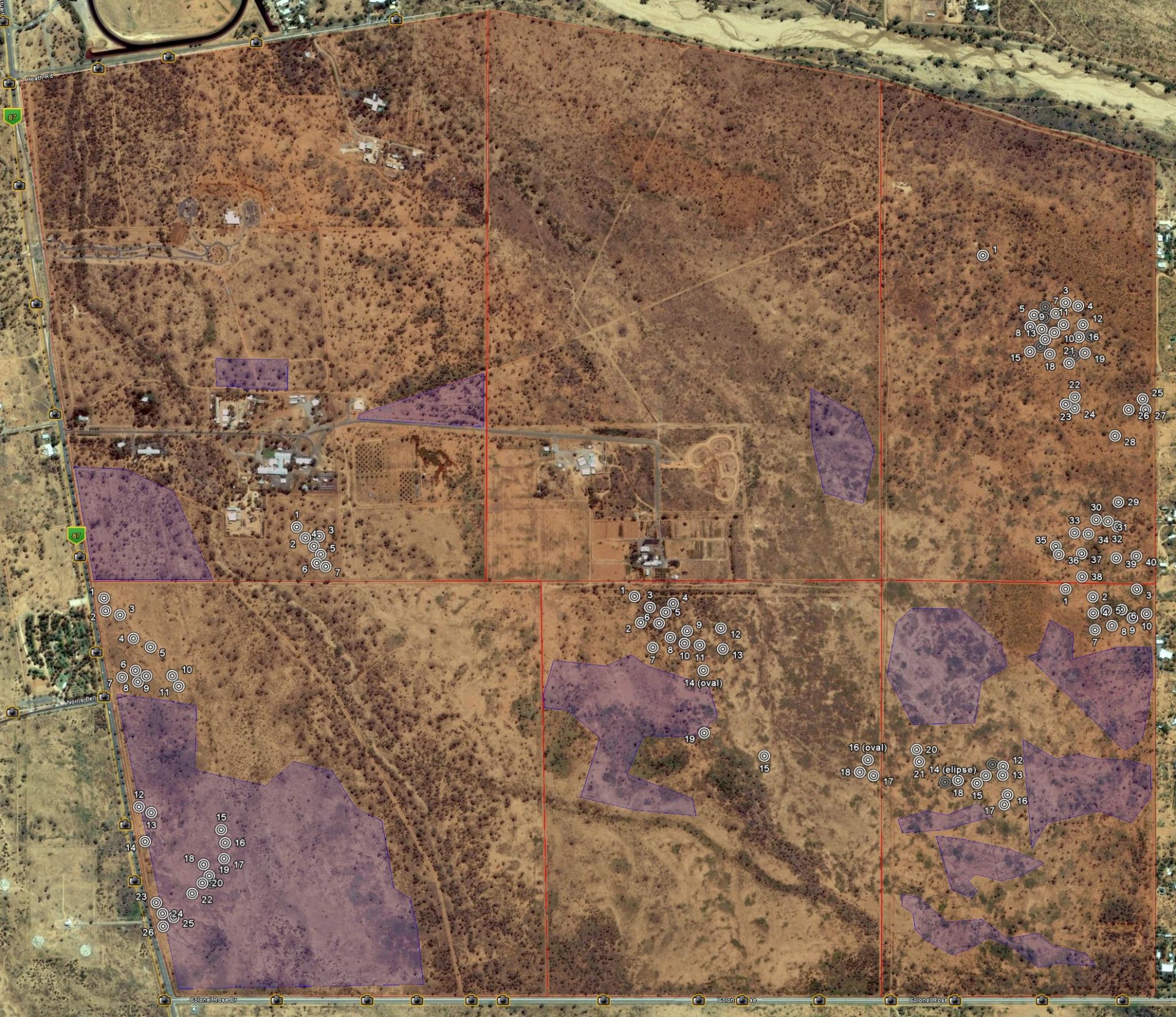
For those with Google Earth, I suggest the download of this "kmz" file with all those features.
Edit: This area includes the areas 2, 3 and 4 from the above post by zorgon.
[edit on 2/9/2009 by ArMaP]
The reddish areas are the six areas in which I divided that bigger area, the blue areas are areas with strange lines or marks in it, the "targets" show the places where I found spirals (with two oval and one elliptical spiral). The coordinates are: 23°46'5.08"S 133°53'19.40"E
(click image for full size)
For those with Google Earth, I suggest the download of this "kmz" file with all those features.
Edit: This area includes the areas 2, 3 and 4 from the above post by zorgon.
[edit on 2/9/2009 by ArMaP]
Here is something that may or may not be relevant. However, this article is related to the indigenous people in NSW. I sent an email to the author,
you never know.
Link
[atsimg]http://files.abovetopsecret.com/images/member/d3c2b672302a.jpg[/atsimg]
Link
Searching for scientific connections that were not superficial, I was amazed by the relevance of the concept of a ‘spiral timeline’. Historical development of scientific ideas is an underpinning theme in NSW science syllabus. We conventionally draw a straight line, horizontal or vertical, divided accurately into years and marking off events/discoveries/scientists births in an orderly fashion. The Aboriginal timeline is linear but in a spiral formation. Oomera explained how there are significant occasions when one can move between the lines – for example, move across and say ‘Sorry’.
[atsimg]http://files.abovetopsecret.com/images/member/d3c2b672302a.jpg[/atsimg]
new topics
-
In an Historic First, In N Out Burger Permanently Closes a Location
Mainstream News: 14 minutes ago -
MH370 Again....
Disaster Conspiracies: 46 minutes ago -
Are you ready for the return of Jesus Christ? Have you been cleansed by His blood?
Religion, Faith, And Theology: 3 hours ago -
Chronological time line of open source information
History: 4 hours ago -
A man of the people
Diseases and Pandemics: 5 hours ago -
Ramblings on DNA, blood, and Spirit.
Philosophy and Metaphysics: 6 hours ago -
4 plans of US elites to defeat Russia
New World Order: 7 hours ago -
Thousands Of Young Ukrainian Men Trying To Flee The Country To Avoid Conscription And The War
Other Current Events: 10 hours ago
top topics
-
Israeli Missile Strikes in Iran, Explosions in Syria + Iraq
World War Three: 14 hours ago, 17 flags -
Thousands Of Young Ukrainian Men Trying To Flee The Country To Avoid Conscription And The War
Other Current Events: 10 hours ago, 7 flags -
Iran launches Retalliation Strike 4.18.24
World War Three: 13 hours ago, 6 flags -
12 jurors selected in Trump criminal trial
US Political Madness: 13 hours ago, 4 flags -
4 plans of US elites to defeat Russia
New World Order: 7 hours ago, 4 flags -
A man of the people
Diseases and Pandemics: 5 hours ago, 3 flags -
Chronological time line of open source information
History: 4 hours ago, 2 flags -
In an Historic First, In N Out Burger Permanently Closes a Location
Mainstream News: 14 minutes ago, 2 flags -
Are you ready for the return of Jesus Christ? Have you been cleansed by His blood?
Religion, Faith, And Theology: 3 hours ago, 1 flags -
Ramblings on DNA, blood, and Spirit.
Philosophy and Metaphysics: 6 hours ago, 1 flags
active topics
-
Thousands Of Young Ukrainian Men Trying To Flee The Country To Avoid Conscription And The War
Other Current Events • 20 • : Consvoli -
Not Aliens but a Nazi Occult Inspired and then Science Rendered Design.
Aliens and UFOs • 15 • : anthelion -
12 jurors selected in Trump criminal trial
US Political Madness • 38 • : ImagoDei -
-@TH3WH17ERABB17- -Q- ---TIME TO SHOW THE WORLD--- -Part- --44--
Dissecting Disinformation • 540 • : IndieA -
Scarface does Tiny Desk Concert
Music • 8 • : zosimov -
In an Historic First, In N Out Burger Permanently Closes a Location
Mainstream News • 0 • : underpass61 -
4 plans of US elites to defeat Russia
New World Order • 28 • : Oldcarpy2 -
Israeli Missile Strikes in Iran, Explosions in Syria + Iraq
World War Three • 72 • : DBCowboy -
Fossils in Greece Suggest Human Ancestors Evolved in Europe, Not Africa
Origins and Creationism • 67 • : strongfp -
Are you ready for the return of Jesus Christ? Have you been cleansed by His blood?
Religion, Faith, And Theology • 10 • : TruthJava