It looks like you're using an Ad Blocker.
Please white-list or disable AboveTopSecret.com in your ad-blocking tool.
Thank you.
Some features of ATS will be disabled while you continue to use an ad-blocker.

Odd-looking Military Aircraft in the Alaskan Wilderness
page: 4share:
3 image composite of those craft. Blended and contrast push to bring out some details. Rough line drawing of what I could discern.
[atsimg]http://files.abovetopsecret.com/images/member/890fe71da841.jpg[/atsimg]
I'm sure someone can do a better job. It still looks to be some variation of an advanced UAV.
[edit on 27-8-2009 by RoofMonkey]
[atsimg]http://files.abovetopsecret.com/images/member/890fe71da841.jpg[/atsimg]
I'm sure someone can do a better job. It still looks to be some variation of an advanced UAV.
[edit on 27-8-2009 by RoofMonkey]
This is a s segment of an aeronautical chart for the region. R-2202B and R-2202C are the MOA areas that cover where the "odd craft" are at. Also
of note, the strip to the south doesn't seem to show up.
The NOTAMs for area ZAN (Anchorage Alaska area) don't mention it specifically... but there are a lot of "don't fly north of so and so"... but NOTAMs are always like that.
[atsimg]http://files.abovetopsecret.com/images/member/c0e56c19f7aa.png[/atsimg]
ARTCC Notices, TFRs and Special Notice Page
The NOTAMs for area ZAN (Anchorage Alaska area) don't mention it specifically... but there are a lot of "don't fly north of so and so"... but NOTAMs are always like that.
[atsimg]http://files.abovetopsecret.com/images/member/c0e56c19f7aa.png[/atsimg]
ARTCC Notices, TFRs and Special Notice Page
The fighters are F15 Eagles for sure. What is not known is whos. Either US or Japanise(Alaska is where they train for Red Flag). As for odd looking,
no not really. If you zoom out the runway is grey, the terrain is brown and the river is frozen. You see the same area from two differnt cameras and
at two differnt times. In one the river is blue(water) and white(ice). In the other the river is all grey. The ice is still there but is a lighter
shade of grey.
Originally posted by darthlung1
The fighters are F15 Eagles for sure.
How do you account for the size discrepancy?
F-15 Strike Eagle:
Length 63 ft 9 in
Wingspan 42 ft 10 in
Item in Photo:
Length ~ 31 to 38 feet
Wingspan ~ 28 feet
And... Google Earth appears to be accuate in measurements at this latitude as shown by the trailer measurements at an oilfield on the North Slope.
[edit on 27-8-2009 by RoofMonkey]
they may be small scale mockups, but that silhouette is an Eagle. And thats IF they are mock ups. Google earth could be wrong.
[edit on 27-8-2009 by darthlung1]
[edit on 27-8-2009 by darthlung1]
reply to post by darthlung1
Oh I'll definitely agree with that... satellite photo analysis is not what it was designed for. But the profile fit may be in error. The picture is just not clear enough, and from what we can see the vertical stabilizers seem to be canted at an angle with no horizontal stabilizers, this would be uncharacteristic of an F-15. More like that of an advanced UAV or F-22/F-35. Of these three, the UAV is in the right size category.
Pretty much all military airfields capable of landing manned aircraft have an FAA designator, even if civilian traffic is not allowed.
flightaware.com...
flightaware.com...
Are good examples. This site is slap dab in the middle of an MOA restriction area, and usualy the only things you see there are training areas and test sites. Again, fitting with the UAV theory.
Edit - Bonus: A C-130 is scheduled to arrive at Elmendorf from Indian Mountain Alaska... FAA desig PAIM.
What is at that 4196 foot gravel airstrip is beyond me. But it's Military, and out in the middle of nowhere.
65°59'34.06"N 153°42'15.44"W
[edit on 27-8-2009 by RoofMonkey]
reply to post by starwarp2000
Thanks for your take Starwarp.
I've also seen the other aircraft at Eielson in that image. The B-1's are located on an area of the flightline we used to call "The Loop". The parking spots along the loop have letter designations like Alpha, Bravo, Charlie, Delta, Echo, Foxtrot, etc.. Though the B-1's were probably there for an exercise since no B-1's are stationed there.
The F-16's in that image belong to the 18th Fighter Squadron.. Looks like they were in between training sorties at the time the image was taken (also called a "turn" in which the aircraft are temporarily parked, refuelled, given munitions again if necessary, and then launched again for the second sorties of the day).
These aircraft at this bizarre landing strip are unlike anything else I've been able to find so far.
They have a very distinct kind of tail-end that is comprised of two vertical stabilizers canted/angled up at an angle. The aircraft appears to have two powerplants as well. But the dimensions of the aircraft are unlike anything else I've seen so far in the inventory.
-ChriS
Originally posted by RoofMonkey
reply to post by darthlung1
Oh I'll definitely agree with that... satellite photo analysis is not what it was designed for. But the profile fit may be in error. The picture is just not clear enough, and from what we can see the vertical stabilizers seem to be canted at an angle with no horizontal stabilizers, this would be uncharacteristic of an F-15. More like that of an advanced UAV or F-22/F-35. Of these three, the UAV is in the right size category.
Pretty much all military airfields capable of landing manned aircraft have an FAA designator, even if civilian traffic is not allowed.
flightaware.com...
flightaware.com...
Are good examples. This site is slap dab in the middle of an MOA restriction area, and usualy the only things you see there are training areas and test sites. Again, fitting with the UAV theory.
In Google Earth, the airstrip is hard to distinguish on the SouthWestern end. The satellite images overlap and the photos of the airstrip at the SW of the area with the parked planes also appears to be much lower resolution. The SW End of the image also appears to have been taken at a different time of day under different lighting conditions (possibly even with a different satellite altogether). Hence, the exaggerated transition from one to the other.

It is interesting that you mention that these could be UAV's.. And not only because of the dimensions of the jets I gave in my first post.
46 miles NorthWest of the airstrip is a very interesting location @..
64°22'44.60"N
147°40'41.88"W
I've never been able to find anything out about this location and noone I've ever asked knows anything about it. It does appear to be another secure area. There are even storage containers along the outside of the square, randomly located, quite possibly with sensing or surveillance equipment.
What is clear is that this particular area is a 1 mile x 1 mile square..

There are a couple of H's at the Northwest corner of the giant square.

But zoom in and look at it and it begins to become clear what these really are..


What you're seeing are 35 foot high poles.. In between the poles are what appear to be cables/ropes, maybe even some kind of netting for recieving incomming UAV's. There are markers that extend out 2000 feet from the netting, much like runway markers or landing beacons would on a runway.
I took a screenshot to try and share what these markers look like (dont' know if the image does it justice).

At the NW corner of the square is what appears to be a control tower. There's even a truck parked outside.. Also a bunch of giant white containers (have no idea what those might be for). See below..
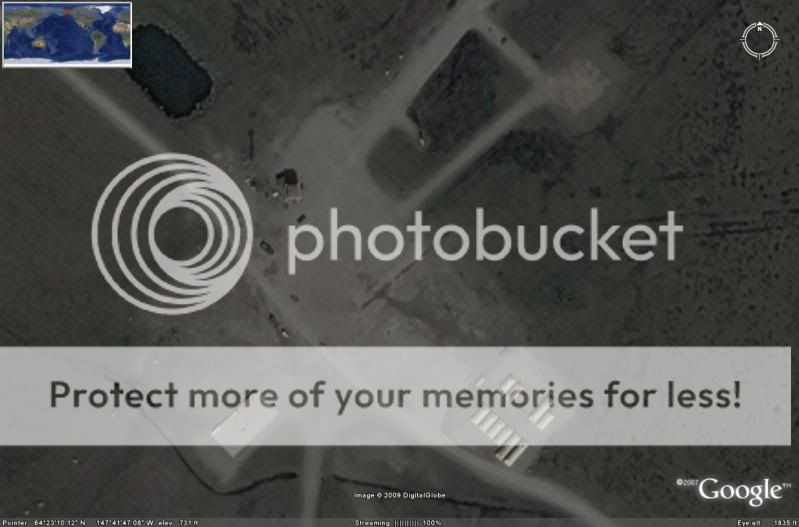
Another interesting thing about this "Giant Square" is that at the SouthEastern corner of the compound there is a fairly large building. Next to the building is what looks like a fuel storage yard. Also notice the trucks. One is a truck with a 40 foot trailer.. I'm unsure what the other equipment might be..
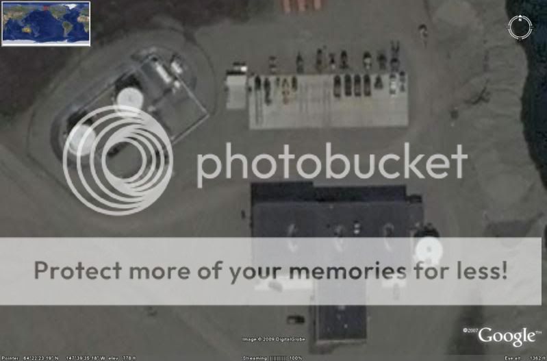
Some of the vehicles are clearly trucks and one is clearly a tractor/trailer. But some of these even look like small wedge-shaped airplanes or small helicopters of some kind. Hard to tell for sure.
-ChriS
[edit on 28-8-2009 by BlasteR]
reply to post by emsed1
The tail section looks more like what we have in the image. The wings are a little off. But what is most telling is the size difference.
News releases say the SHARC UAV is 250 cm long, 70 cm wide and 120 cm high.
That's far too small to be in the range-size of the aircraft at the airstrip in google earth. These airplanes are much bigger (maybe even larger versions of the SHARC).
It could still be a UAV of some kind (especially given the content of my last post) but It's just still unclear what they might be.
Given the site I talked about in my last post, these could be facilities in the process of testing and development for a new kind of UAV. The site to recieve the UAV's is in place just 46 miles to the NW. That would give a super-secret UAV alot of airspace to fly around in that is complete and utter wilderness. And when it lands, it can land at an EXTREMELY remote site over 30 miles from the nearest city, town, or military installation..where noone ever has to know it was there.
All the flight testing can take place where noone would ever see it. And it can even land and fly back to the secret airstrip with the same kind of secrecy. If maintenance needs to be done after it lands, they can haul it in to one of the buildings they have at the "Giant Square" and conduct maintenance on the airplane.. Even refuel it if necessary since they also have a fuel yard / refueling station. Very interesting.
-ChriS
reply to post by emsed1
Hi emsed! Welcome to the thread.
Barracuda UCAV
Wingpsan... approximately 33 feet, 10 inches.
Length....... 26 feet, 3 inches (about 8 meters)
The Barracuda is about the same dimensions as the Boeing X-45.. But the X-45 doesn't even have vertical stabilizers. It is built with a "flying wing" configuration like the B-2.
Image of the Boeing X-45..
www.fortunecity.com...
Another problem is the Barracuda was developed by the Germans. Unless we bought some from the Germans or copied the design, I doubt a bunch of them would be parked at a secure facility in the middle of the Alaskan wilderness, right?
But I also found an image that shows a size comparison (to scale) for a few different kinds of UCAV's..

the Logiduc UCAV demonstrator also has the canted vertical stabilizers in the rear like the jets parked on that airstrip.
But another problem with this one too. It's a french UCAV designed by the French company "Dassault". Also, the more recent variant of the Logiduc UCAV demonstrator is the French "AVE-D Petit Duc" designed by the same company (and the newer version doesn't have the vertical stabilizers anyway).
Still a big mystery as to what these might be. Whatever they are, if they are experimental American UAV's they are something new. And the military is probably taking these much more seriously than a simple prototype if they already have a squadron of these things along with a secret, remote airstrip to launch them.. And then a site 46 miles to the NW to recieve them if necessary... All in such a remote location, the job of engineering and constructing both sites was probably a logistical nightmare.
-ChriS
[edit on 28-8-2009 by BlasteR]
Hi emsed! Welcome to the thread.
Barracuda UCAV
Wingpsan... approximately 33 feet, 10 inches.
Length....... 26 feet, 3 inches (about 8 meters)
The Barracuda is about the same dimensions as the Boeing X-45.. But the X-45 doesn't even have vertical stabilizers. It is built with a "flying wing" configuration like the B-2.
Image of the Boeing X-45..
www.fortunecity.com...
Another problem is the Barracuda was developed by the Germans. Unless we bought some from the Germans or copied the design, I doubt a bunch of them would be parked at a secure facility in the middle of the Alaskan wilderness, right?
But I also found an image that shows a size comparison (to scale) for a few different kinds of UCAV's..
the Logiduc UCAV demonstrator also has the canted vertical stabilizers in the rear like the jets parked on that airstrip.
But another problem with this one too. It's a french UCAV designed by the French company "Dassault". Also, the more recent variant of the Logiduc UCAV demonstrator is the French "AVE-D Petit Duc" designed by the same company (and the newer version doesn't have the vertical stabilizers anyway).
Still a big mystery as to what these might be. Whatever they are, if they are experimental American UAV's they are something new. And the military is probably taking these much more seriously than a simple prototype if they already have a squadron of these things along with a secret, remote airstrip to launch them.. And then a site 46 miles to the NW to recieve them if necessary... All in such a remote location, the job of engineering and constructing both sites was probably a logistical nightmare.
-ChriS
[edit on 28-8-2009 by BlasteR]
I went to Anchorage yesterday to have a medical procedure done. While waiting in the airport, just sitting there eating my Bugles and sucking down a
Dr. Pepper, I watched as a completely unmarked 707 taxis by with 2 trucks following. One of the trucks was an American Airlines pickup truck.. The
other pickup truck was unmarked.
The aircraft was akin to the infamous "JANET" planes that transport military and civilian personnel to and from Area51.
This one didn't have a red stripe though. This one was white with a small blue and baby-blue stripe down the middle.. And then one of those same strips about halfway up the vertical stabilizer.
After some quick thinking I got the tail number (the only thing on the jet anywhere).
N959BP
I'm not sure how often unmarked aircraft go rolling by the gate of a large commercial airline.. But it turns out, this is what I saw...

Airframe Info
Manufacturer: Boeing
Model: 737-7BD Search all Boeing 737-7BD
Year built: 2008
Construction Number (C/N): 36720
Number of Seats: 149
Number of Engines: 2
Engine Manufacturer and Model: Cfm Intl CFM56-7B22
Link this airframe to another registry number
Owner
Registration Type: Corporation
Owner: Fifth Third Leasing Co
Address: 700 G St
Anchorage, AK 99501
United States
Region: Alaskan
Status
Certification Class: Standard
Certification Issued: 2008-08-21
Air Worthiness Test: 2008-06-03
Last Action Taken: 2008-09-24
Current Status: Valid
INFO and IMAGE all thanks to a friend of mine here on ATS that I won't identify unless he wants to himself !!
It seems to belong to The "Fifth Third Leasing Company, a subsidiary of Fifth Third Bank". That's about all we can tell on this one. Or maybe the gov just figured out a neat way to keep 707 transports a little more private than just registering them as "government owned and operated" like the Janet planes (LOL!).
-ChriS
The aircraft was akin to the infamous "JANET" planes that transport military and civilian personnel to and from Area51.
This one didn't have a red stripe though. This one was white with a small blue and baby-blue stripe down the middle.. And then one of those same strips about halfway up the vertical stabilizer.
After some quick thinking I got the tail number (the only thing on the jet anywhere).
N959BP
I'm not sure how often unmarked aircraft go rolling by the gate of a large commercial airline.. But it turns out, this is what I saw...
Airframe Info
Manufacturer: Boeing
Model: 737-7BD Search all Boeing 737-7BD
Year built: 2008
Construction Number (C/N): 36720
Number of Seats: 149
Number of Engines: 2
Engine Manufacturer and Model: Cfm Intl CFM56-7B22
Link this airframe to another registry number
Owner
Registration Type: Corporation
Owner: Fifth Third Leasing Co
Address: 700 G St
Anchorage, AK 99501
United States
Region: Alaskan
Status
Certification Class: Standard
Certification Issued: 2008-08-21
Air Worthiness Test: 2008-06-03
Last Action Taken: 2008-09-24
Current Status: Valid
INFO and IMAGE all thanks to a friend of mine here on ATS that I won't identify unless he wants to himself !!
It seems to belong to The "Fifth Third Leasing Company, a subsidiary of Fifth Third Bank". That's about all we can tell on this one. Or maybe the gov just figured out a neat way to keep 707 transports a little more private than just registering them as "government owned and operated" like the Janet planes (LOL!).
-ChriS
reply to post by BlasteR
That new location is the BLAIR LAKES RANGE FACILITY. Fuel/ maintenace for ground equipment using the Range.
That new location is the BLAIR LAKES RANGE FACILITY. Fuel/ maintenace for ground equipment using the Range.
reply to post by BlasteR
Yep same info, I got
FAA REGISTRY Tail Number: N959BP
Gotta pay for service records, although I don't think i will get them
Yep same info, I got
FAA REGISTRY Tail Number: N959BP
Gotta pay for service records, although I don't think i will get them
reply to post by BlasteR
The Fifth Third Leasing Company
38 Fountain Square Plz
Cincinnati, OH 45202
Phone: (513) 579-5300
Website: Information not found (?)
Business Categories
Equipment rental and leasing, nec in Cincinnati, OH
Equipment Rental/Leasing
The Fifth Third Leasing Company Business Information
The Fifth Third Leasing Company is a private company categorized under Equipment rental and leasing, nec and located in Cincinnati, OH. Current estimates show this company has an annual revenue of $3,900,000 and employs a staff of approximately 50.
Also Does Business As
Information not found (?)
HQ, Branch or Single Location
Headquarters
Annual Sales (Estimated)
$3,900,000
Employees (Estimated)
50
SIC Code and Description
7359, Equipment Rental and Leasing, NEC
NAICS Code and Description
532490, Other Commercial and Industrial Machinery and Equipment Rental and Leasing
Parent Company
The Fifth Third Bank
Years in Business
21
The Fifth Third Leasing Company
The Fifth Third Bank
Parent Company
Fifth Third Financial Corporation
Fifth Third Financial Corporation
Parent Company
Fifth Third Bancorp
Fifth Third Bancorp Business Information
Fifth Third Bancorp is a public company categorized under State commercial banks and located in Cincinnati, OH. Our records show it was established in 1858 and incorporated in Ohio. Current estimates show this company has an annual revenue of $8,494,000,000 and employs a staff of approximately 23,458.
WOW, what a trail of companies.
Reminds me of how Black Ops, shill accounts are organized
The Fifth Third Leasing Company
38 Fountain Square Plz
Cincinnati, OH 45202
Phone: (513) 579-5300
Website: Information not found (?)
Business Categories
Equipment rental and leasing, nec in Cincinnati, OH
Equipment Rental/Leasing
The Fifth Third Leasing Company Business Information
The Fifth Third Leasing Company is a private company categorized under Equipment rental and leasing, nec and located in Cincinnati, OH. Current estimates show this company has an annual revenue of $3,900,000 and employs a staff of approximately 50.
Also Does Business As
Information not found (?)
HQ, Branch or Single Location
Headquarters
Annual Sales (Estimated)
$3,900,000
Employees (Estimated)
50
SIC Code and Description
7359, Equipment Rental and Leasing, NEC
NAICS Code and Description
532490, Other Commercial and Industrial Machinery and Equipment Rental and Leasing
Parent Company
The Fifth Third Bank
Years in Business
21
The Fifth Third Leasing Company
The Fifth Third Bank
Parent Company
Fifth Third Financial Corporation
Fifth Third Financial Corporation
Parent Company
Fifth Third Bancorp
Fifth Third Bancorp Business Information
Fifth Third Bancorp is a public company categorized under State commercial banks and located in Cincinnati, OH. Our records show it was established in 1858 and incorporated in Ohio. Current estimates show this company has an annual revenue of $8,494,000,000 and employs a staff of approximately 23,458.
WOW, what a trail of companies.
Reminds me of how Black Ops, shill accounts are organized
reply to post by BlasteR
Hi Blaster,
I took a look at your Google Earth picture of that facility:
64°22'44.60"N, 147°40'41.88"W
Being an inquisitive type, I thought, I wonder where that road goes, to the North?
After following it for a while came across these:
Top Ball: 64°40'30.56"N, 147°41'19.18"W
Bottom Ball: 64°40'29.05"N, 147°41'19.12"W
They look like Radomes to me. They are out in the middle of nowhere but, and unless the facilities are underground, they are most strange.
reply to post by skycopilot
I think that was propaganda to try to get the soviets to develop one that could...much like star wars imo..reaguns successfull plan to bankrupt the union............................. and let it fall into the hands of the mafia...
I think that was propaganda to try to get the soviets to develop one that could...much like star wars imo..reaguns successfull plan to bankrupt the union............................. and let it fall into the hands of the mafia...
reply to post by zorgon
Hey Zorgs,
That Mig 29 has Luftwaffe Isignia.
Are they the ones in Red Flag???
I know they were flying down in Arizona, and one Air Traffic Controller said it was like being at Berlin Airport. (They kept speaking in German).
In more than one instance, they have 'strayed' into restricted areas
EDIT TO ADD:
Yes the Mig-29 and Su-17 (And latter variants) can both take off from unsealed runways. They have covers which drop down over the air intakes and those lines you see on top of the aircraft (On the leading edge extensions) are where the air is taken in for take off. This prevents the engines sucking in FOD (Foreign Object Damage) from ground level.
[edit on 28/8/09 by starwarp2000]
Originally posted by starwarp2000
reply to post by BlasteR
Yep same info, I got
FAA REGISTRY Tail Number: N959BP
Gotta pay for service records, although I don't think i will get them
I have the free account on Flight Aware. You can get four months of flight history data.
This is the result of N959BP
No History Data (searched last 4 months)
Best I can figure, is it arrived in Alaska last year, and has ceased to exist....
Aircraft Boeing 737-700 (twin-jet) (B737/W - track or photos)
Origin Kelowna Int'l (CYLW / YLW - track or info)
Destination Anchorage Intl (PANC - track or info)
Route n/a
Date Tuesday, Sep 23, 2008
Duration 2 hours 41 minutes
[edit on 28-8-2009 by RoofMonkey]
new topics
-
Michigan school district cancels lesson on gender identity and pronouns after backlash
Education and Media: 3 minutes ago -
When an Angel gets his or her wings
Religion, Faith, And Theology: 56 minutes ago -
Comparing the theology of Paul and Hebrews
Religion, Faith, And Theology: 1 hours ago -
Pentagon acknowledges secret UFO project, the Kona Blue program | Vargas Reports
Aliens and UFOs: 2 hours ago -
Boston Dynamics say Farewell to Atlas
Science & Technology: 2 hours ago -
I hate dreaming
Rant: 3 hours ago -
Man sets himself on fire outside Donald Trump trial
Mainstream News: 5 hours ago -
Biden says little kids flip him the bird all the time.
Politicians & People: 5 hours ago -
The Democrats Take Control the House - Look what happened while you were sleeping
US Political Madness: 6 hours ago -
Sheetz facing racial discrimination lawsuit for considering criminal history in hiring
Social Issues and Civil Unrest: 6 hours ago
top topics
-
The Democrats Take Control the House - Look what happened while you were sleeping
US Political Madness: 6 hours ago, 16 flags -
In an Historic First, In N Out Burger Permanently Closes a Location
Mainstream News: 8 hours ago, 14 flags -
A man of the people
Medical Issues & Conspiracies: 13 hours ago, 8 flags -
Biden says little kids flip him the bird all the time.
Politicians & People: 5 hours ago, 8 flags -
Man sets himself on fire outside Donald Trump trial
Mainstream News: 5 hours ago, 7 flags -
Pentagon acknowledges secret UFO project, the Kona Blue program | Vargas Reports
Aliens and UFOs: 2 hours ago, 5 flags -
4 plans of US elites to defeat Russia
New World Order: 15 hours ago, 4 flags -
Sheetz facing racial discrimination lawsuit for considering criminal history in hiring
Social Issues and Civil Unrest: 6 hours ago, 3 flags -
Boston Dynamics say Farewell to Atlas
Science & Technology: 2 hours ago, 3 flags -
Are you ready for the return of Jesus Christ? Have you been cleansed by His blood?
Religion, Faith, And Theology: 10 hours ago, 3 flags
active topics
-
Thousands Of Young Ukrainian Men Trying To Flee The Country To Avoid Conscription And The War
Other Current Events • 49 • : RickyD -
I hate dreaming
Rant • 6 • : Hecate666 -
Israeli Missile Strikes in Iran, Explosions in Syria + Iraq
World War Three • 102 • : DumbNut -
Michigan school district cancels lesson on gender identity and pronouns after backlash
Education and Media • 0 • : Consvoli -
The Democrats Take Control the House - Look what happened while you were sleeping
US Political Madness • 61 • : Threadbarer -
Man sets himself on fire outside Donald Trump trial
Mainstream News • 32 • : cherokeetroy -
Pentagon acknowledges secret UFO project, the Kona Blue program | Vargas Reports
Aliens and UFOs • 5 • : Ophiuchus1 -
-@TH3WH17ERABB17- -Q- ---TIME TO SHOW THE WORLD--- -Part- --44--
Dissecting Disinformation • 546 • : MetalThunder -
Boston Dynamics say Farewell to Atlas
Science & Technology • 4 • : Terpene -
12 jurors selected in Trump criminal trial
US Political Madness • 111 • : WeMustCare