It looks like you're using an Ad Blocker.
Please white-list or disable AboveTopSecret.com in your ad-blocking tool.
Thank you.
Some features of ATS will be disabled while you continue to use an ad-blocker.

Odd-looking Military Aircraft in the Alaskan Wilderness
page: 10share:
Anyone care to take a shot at identifying the object in the last post?
The v shaped white thingy.
The v shaped white thingy.
those have to be drones or some new kind of ordanace as they look SMALL but not quite tomahawk small bump?
Hello all!
I have something to share with you that I just discovered today.
A while back I found an online PDF file that included maps and soil sampling of Donnelly Training Area.
I didn't notice it at the time because I wasn't looking in the right place.. But it turns out that at least one of those maps shows the area of the runway labeled as..."UAV Landing Strip".
I'm doing research right now trying to track down that very same PDF file so you call can see what I saw today.. but I do know it is information within the public domain and it is not confidential or classified in any way.
If nothing else, I'll scan the hardcopy I have so you all can see for yourselves.
I was pretty shocked when I saw this guys n gals! Especially after everything we've talked about in this thread. The aircraft do appear to have the dimensions and overall characteristics of drones/UAV's, just as we've been discussing.
This new information would solidify that theory since the source of the information is the government itself.. We could very well be seeing a new kind of drone/UAV since we have yet to find anything in the inventory that is anywhere close to the overall size, shape or characteristics.
-ChriS
[edit on 26-7-2010 by BlasteR]
reply to post by BlasteR
Here is a link to a document that shows the area of UAV ops.
UAV Operations in Alaska
Here is a link to a document that shows the area of UAV ops.
UAV Operations in Alaska
Originally posted by ajsr71
reply to post by BlasteR
Here is a link to a document that shows the area of UAV ops.
UAV Operations in Alaska
Interesting!
I think I'll map out all the coordinates in google earth so all the areas are shown geographically.
Never seen that one before.
-ChriS
I was able to track down and find the PDF file I mentioned earlier.
It was not easy to find. Only way I could find this particular PDF is by manually browsing to it.
There are many other maps like this (about 20 or 30) and all show various types and degrees of information about Donnelly Training Area in general. Archaeological survey sites, soil types, average sound levels, etc...
This particular PDF is entitled:
"Figure 4.k, Donnelly Training Area Infrastructure".
Southwest of "Pump Station #9" along Meadows Road (which is one of the pump stations for the Alyeska pipeline), is a region entitled "UAV Landing Strip" and I point this out for obvious reasons. It does not appear to be exactly in the area of these aircraft as I previously thought but this is the first and only map of this area I've seen that labels anything as a "UAV Landing Strip".
I'm going to work on making some overlays for geographical reference and post back here when I'm done. Maybe then we can tell which airstrip is being referred to.
Just for reference, the map below was referred to earlier on in the thread and shows names for at least some of the airstrips in Donnelly Training Area.
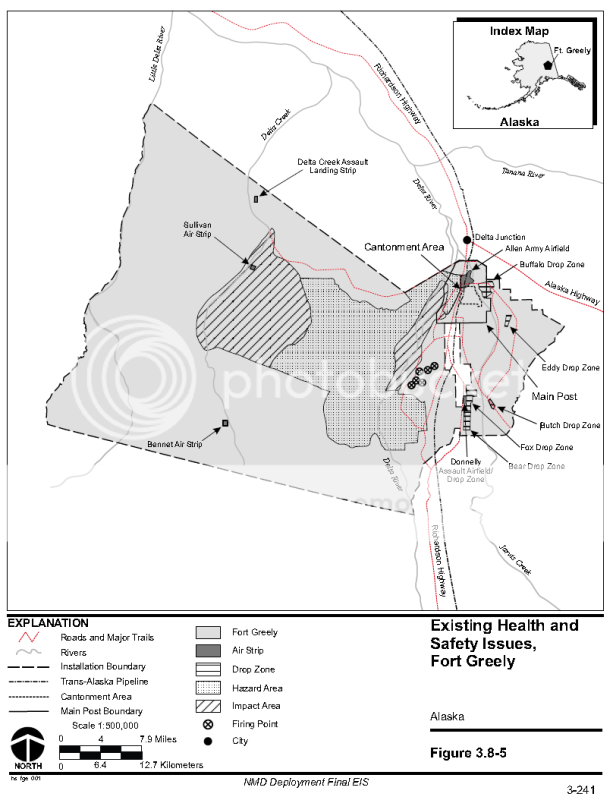
The map does not show an airstrip in the area labeled as "UAV landing strip" in the PDF file.
-ChriS
It was not easy to find. Only way I could find this particular PDF is by manually browsing to it.
There are many other maps like this (about 20 or 30) and all show various types and degrees of information about Donnelly Training Area in general. Archaeological survey sites, soil types, average sound levels, etc...
This particular PDF is entitled:
"Figure 4.k, Donnelly Training Area Infrastructure".
Southwest of "Pump Station #9" along Meadows Road (which is one of the pump stations for the Alyeska pipeline), is a region entitled "UAV Landing Strip" and I point this out for obvious reasons. It does not appear to be exactly in the area of these aircraft as I previously thought but this is the first and only map of this area I've seen that labels anything as a "UAV Landing Strip".
I'm going to work on making some overlays for geographical reference and post back here when I'm done. Maybe then we can tell which airstrip is being referred to.
Just for reference, the map below was referred to earlier on in the thread and shows names for at least some of the airstrips in Donnelly Training Area.
The map does not show an airstrip in the area labeled as "UAV landing strip" in the PDF file.
-ChriS
Originally posted by ajsr71
reply to post by BlasteR
Here is a link to a document that shows the area of UAV ops.
UAV Operations in Alaska
Thanks again for the map.
The coordinates given provide launch and recovery corridors for UAV's operating in this area (though perhaps not all). The procedures are specified as to where the UAV's will go and what they'll do when the signal is lost, stuff like this.
The coordinates given in the document specify the launch corridors and typical flight paths for the UAV's. Unfortunately, none of the sites specified in this document are anywhere near the aircraft in question. None of the flight corridors described go near them either.
Nonetheless, here are some of the sites given for launch/recovery operations of UAV's in no particular order. Most of these I already knew about. Husky DZ is the only site not known to me previously.
Allen Army Airfield - Main Airfield for Fort Greely
Donnelly Assault Airstrip - Just South of Greely
DFS - 12 miles south of Donnelly Assault Strip
Firebird Dropzone - within PARC (Pacific Alaska Range Complex) - site is remote airstrip 13.8 miles Southeast of Eielson AFB
Husky Dropzone - Remote airstrip 6.4 miles North of Eielson. Doesn't even really look like an airstrip but it is used as one apparently.
Firebird Dropzone within PARC (Pacific Alaska Range Complex) - Site is remote airstrip 13.8 miles Southeast of Eielson AFB
Bryant Army Heliport - At Fort Richardson
What the document tells me is that the site in question is possibly being used for UAV's and that information is classified OR the aircraft that we see in google earth are not UAV's. What we know to be fact is that the airstrip with these strange aircraft is being actively used by both the Army and the Air Force for a variety of purposes.
This means that these strange aircraft we're seeing in google earth are very real aircraft (UAV or not) and are shown in google earth "parked" in various locations with relation to the airstrip.
These aircraft are still unlike anything else we know of publicly!
-ChriS
reply to post by BlasteR
hi blaster, not sure if this has been covered or not as i haven't had chance to read all the thread yet but i have a suggestion on the planes in the original area of your op, i could be way off but maybe the shadow and jpegging/resolution is masking the real shape and configuration of the planes and maybe they only have one vertical stabiliser but the shadow and horizontals are giving the illusion of twin verticals, my suggestion is they could be one of the many types of harrier, the dimensions of some would seem to fit your measurements and they have twin intakes.
en.wikipedia.org...
thanks
rich
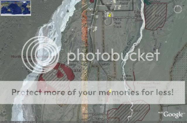
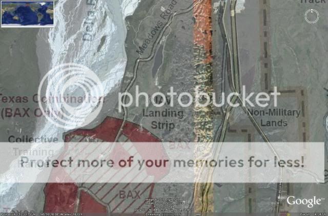
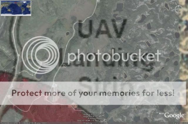
So I did an overlay of the map discussed earlier (Figure 4K from previous post) and I was able to figure out which airstrip was being referred to as
"UAV Landing Strip".
Unforunately, it is not anywhere near the aircraft in question as I had suspected.
I'm unsure the name of this particular airstrip or if it even has one. For curious minds, it can be seen in Google Earth within the North Texas "Combination" training area @ coordinates:
63°52'4.45"N
145°51'30.24"W
See overlay images below..
-ChriS
Originally posted by RICH-ENGLAND
reply to post by BlasteR
hi blaster, not sure if this has been covered or not as i haven't had chance to read all the thread yet but i have a suggestion on the planes in the original area of your op, i could be way off but maybe the shadow and jpegging/resolution is masking the real shape and configuration of the planes and maybe they only have one vertical stabiliser but the shadow and horizontals are giving the illusion of twin verticals, my suggestion is they could be one of the many types of harrier, the dimensions of some would seem to fit your measurements and they have twin intakes.
en.wikipedia.org...
thanks
rich
Only a couple things wrong with that theory though.
1) Harrier wingspan is going to be off by anywhere from 2-3 feet (depending on model).
2) The overall Length of even the smallest Harrier is still 42'-6" which is like 10 feet larger than the length of the aircraft parked at this site in google earth (I believe we now know it is called Sullivan Airstrip).
3) The images are clear enough that we can see the detail of the twin vertical stabilizers at the rear canted upwards at an angle. This is the same for all of the aircraft parked at this site regardless of their orientation or location. The shadows casted on the ground also prove there are two vertical stabilizers instead of one.
The images below were previously posted. I'll post them again just to refresh everyone's memory and show that the characteristics and dimensions of these aircraft are extremely unique.


-ChriS
I decided to do a little pen and paper math and do a little image comparison for size. I don't know if this will help anyone, but here it is!
These aircraft seem to be quite small, about the size of a single engine cessna with a smaller wingspan, but longer body.
I took into account the Eye altitude and the elevation of the land.
I also thought the shape looked like an f-15, so I did a comparison of a top view of an f-15:
I can't account for size but the dimensions seem right.
[Edited to add second picture]
[edit on 7/29/2010 by Sararainmaker]
reply to post by BlasteR
hi blaster, personally i think there's something wrong in the measurements, im not saying that you personally have made errors but maybe something to do with with the photographs scaling or any processing thay may or may not have been done, my reasoning for this thought is that even small trainer jets like the bae hawk are 40` so that leads me to believe that any manned jet at 30' would be absolutely hopeless, dont think there would be enough room for a powerful enough engine to lift anything of note or be of much use, ive been close up to most jets this week at farnborough airshow, including the hawk so i honestly doubt that a manned jet at 30' in the fighter type configuration would be very practical.
thanks
rich
Maybe they're actually dummy targets for UAV operators to practice "hitting".
reply to post by Sararainmaker
that looks pretty close to me and i think you're probably right, i think the shadows and resolution are causing illusions and making the planes look different to what they actually are.
thanks
rich
that looks pretty close to me and i think you're probably right, i think the shadows and resolution are causing illusions and making the planes look different to what they actually are.
thanks
rich
reply to post by RICH-ENGLAND
Not a problem! I can't say I am correct by any means not having any military experience other than living by an AFB most of my life.
You do get familiar with what the planes look like and what they sound like though, and to my time-trained eye, thats what it looked like.
I did a little math, but I can't promise to be any good at it... math scares me.
In all honesty with the image as low a quality as it is, it's just about the same as looking at an ultrasound of a child in-womb. pretty much guessing thats the butt and hoping it's not the face!
[Edited: Added last part.]
[edit on 7/29/2010 by Sararainmaker]
and just to further add, on blaster,s question "could this be aurora"?. in all honesty i dont think there is an actual aurora plane, it was just a
codename for the B2, BUT i do think there's very probably a replacement for the SR71 but these planes would definitely not be them for many reasons,
firstly if america did have a top secret superplane they wouldn't leave them out to be photographed by satellites or anything, secondly i would
imagine it would still be a very similar size and layout/configuration to the SR71 due to all the obvious reasons like extreme high speed, altitude
and range and also would still need to be able to carry a decent payload, whereas these planes seem to have a fighter/attack layout/configuration.
thanks
rich
[edit on 29-7-2010 by RICH-ENGLAND]
thanks
rich
[edit on 29-7-2010 by RICH-ENGLAND]
I've been reading everyone's replies thus far and thought I'd add the results of some of my research. I seriously doubt that this is an F-15 for a
variety of reasons.
For starters, from what I've found the minimum runway distance for the standard F-15 is 7,500 feet. SOURCE1
The link is wikipedia talking about the F-15_STOL but it does mention the 7,500 feet runway distance.
If these were F-15's they would probably be the ones out of Elmendorf which, according to THIS, has a runway length of 10,000 feet for Runway #1 and 7,505 feet for runway #2.
We can compare this typical minimum runway distance for the F-15 to "Sullivan Airstrip" in google earth, which is where these aircraft are parked.
Minimum runway distance for a standard F-15: 7,500 Feet
Runway distance of "Sullivan Airstrip": approx. 7,500 Feet (almost exactly).
BUT HOLD THE PHONE!
Here's how I came to this figure..
I believe the larger, wider, landing strip of the three at this site is the primary. Google earth also shows about 5 planes parked perpendicular to and right next to this wider strip so I'm assuming this is the one being used for these aircraft. I also excluded the narrower taxiway at the back end of the main strip (Northeast of the main strip).
This tells us that the airstrip is capable of safely recovering and launching F-15's, even if only barely, but it also tells us that the dimensions in google earth must be pretty accurate. The dimensions in google earth are probably never going to be 100% but in order for the length of this airstrip to be measured so precisely tells us that the dimensions of the aircraft I provided must ALSO be very close.
If the measured distances in google earth were to be in error, it would mean there would be a consistent margin of error per unit measured for that particular image.
As far as the airstrip and the aircraft parked there, if the sizes of the images were too small by even an inch per foot the length of the runway would be nowhere near the exact 7,500 foot figure. It would actually measure at 6,875 feet or so. It would be off by 625 feet!
I think it's safe to say the main airstrip is 7,500 feet long. But this presents a size discrepancy with these aircraft when compared to the F-15.
Dimensions of the aircraft parked at this airstrip:
Wingspan: 28'-0"
Length: 37'-0"
Dimensions of the standard F-15:
Wingspan: 42'-10"
Length: 63'-9"
There is no way that the margin of error in google earth is off by so much that it would explain this huge size discrepancy. For starters, the length given in google earth would have to be off by 26'-9". Then the wingspan given in google earth would have to be off by 14'-10".
I explained how I came to these dimensions earlier. I drew a 100' line in google earth. I then dropped an image of the aircraft and the 100' line as a raster image in Autocad and scaled the photo to full (100%) scale in Autocad. To do this, you simply draw a 100' line in Autocad and make sure when you scale the raster image so the two lines are identical. Doing this allows you to accurately determine sizes of other things within the image. It's something I've done for work-related stuff a few times. It always works and is always accurate.
If the dimensions I provided are pretty accurate, which I believe they are, then a real side-by-side comparison with an F-15 would look more like this:

How would it even be possible that the airstrip can be measured so accurately in google earth at 7,500 feet but an F-15 parked there would be 26'-9" too short?
I think we are seeing UAV's that are way too small to be F-15's or any other aircraft in the inventory. There just isn't anything we know of that is this small with these characteristics.
-ChriS
For starters, from what I've found the minimum runway distance for the standard F-15 is 7,500 feet. SOURCE1
The link is wikipedia talking about the F-15_STOL but it does mention the 7,500 feet runway distance.
landing on just 1,650 ft (500 m) of runway compared to 7,500 ft (2,300 m) for the standard F-15
If these were F-15's they would probably be the ones out of Elmendorf which, according to THIS, has a runway length of 10,000 feet for Runway #1 and 7,505 feet for runway #2.
We can compare this typical minimum runway distance for the F-15 to "Sullivan Airstrip" in google earth, which is where these aircraft are parked.
Minimum runway distance for a standard F-15: 7,500 Feet
Runway distance of "Sullivan Airstrip": approx. 7,500 Feet (almost exactly).
BUT HOLD THE PHONE!
Here's how I came to this figure..
I believe the larger, wider, landing strip of the three at this site is the primary. Google earth also shows about 5 planes parked perpendicular to and right next to this wider strip so I'm assuming this is the one being used for these aircraft. I also excluded the narrower taxiway at the back end of the main strip (Northeast of the main strip).
This tells us that the airstrip is capable of safely recovering and launching F-15's, even if only barely, but it also tells us that the dimensions in google earth must be pretty accurate. The dimensions in google earth are probably never going to be 100% but in order for the length of this airstrip to be measured so precisely tells us that the dimensions of the aircraft I provided must ALSO be very close.
If the measured distances in google earth were to be in error, it would mean there would be a consistent margin of error per unit measured for that particular image.
As far as the airstrip and the aircraft parked there, if the sizes of the images were too small by even an inch per foot the length of the runway would be nowhere near the exact 7,500 foot figure. It would actually measure at 6,875 feet or so. It would be off by 625 feet!
I think it's safe to say the main airstrip is 7,500 feet long. But this presents a size discrepancy with these aircraft when compared to the F-15.
Dimensions of the aircraft parked at this airstrip:
Wingspan: 28'-0"
Length: 37'-0"
Dimensions of the standard F-15:
Wingspan: 42'-10"
Length: 63'-9"
There is no way that the margin of error in google earth is off by so much that it would explain this huge size discrepancy. For starters, the length given in google earth would have to be off by 26'-9". Then the wingspan given in google earth would have to be off by 14'-10".
I explained how I came to these dimensions earlier. I drew a 100' line in google earth. I then dropped an image of the aircraft and the 100' line as a raster image in Autocad and scaled the photo to full (100%) scale in Autocad. To do this, you simply draw a 100' line in Autocad and make sure when you scale the raster image so the two lines are identical. Doing this allows you to accurately determine sizes of other things within the image. It's something I've done for work-related stuff a few times. It always works and is always accurate.
If the dimensions I provided are pretty accurate, which I believe they are, then a real side-by-side comparison with an F-15 would look more like this:
How would it even be possible that the airstrip can be measured so accurately in google earth at 7,500 feet but an F-15 parked there would be 26'-9" too short?
I think we are seeing UAV's that are way too small to be F-15's or any other aircraft in the inventory. There just isn't anything we know of that is this small with these characteristics.
-ChriS
new topics
-
Chris Christie Wishes Death Upon Trump and Ramaswamy
Politicians & People: 7 minutes ago -
University of Texas Instantly Shuts Down Anti Israel Protests
Education and Media: 2 hours ago -
Any one suspicious of fever promotions events, major investor Goldman Sachs card only.
The Gray Area: 4 hours ago -
God's Righteousness is Greater than Our Wrath
Religion, Faith, And Theology: 8 hours ago
top topics
-
VP's Secret Service agent brawls with other agents at Andrews
Mainstream News: 13 hours ago, 10 flags -
Cats Used as Live Bait to Train Ferocious Pitbulls in Illegal NYC Dogfighting
Social Issues and Civil Unrest: 17 hours ago, 8 flags -
Nearly 70% Of Americans Want Talks To End War In Ukraine
Political Issues: 14 hours ago, 5 flags -
Electrical tricks for saving money
Education and Media: 12 hours ago, 4 flags -
Sunak spinning the sickness figures
Other Current Events: 14 hours ago, 4 flags -
Late Night with the Devil - a really good unusual modern horror film.
Movies: 16 hours ago, 2 flags -
Any one suspicious of fever promotions events, major investor Goldman Sachs card only.
The Gray Area: 4 hours ago, 2 flags -
University of Texas Instantly Shuts Down Anti Israel Protests
Education and Media: 2 hours ago, 1 flags -
God's Righteousness is Greater than Our Wrath
Religion, Faith, And Theology: 8 hours ago, 0 flags -
Chris Christie Wishes Death Upon Trump and Ramaswamy
Politicians & People: 7 minutes ago, 0 flags
active topics
-
Any one suspicious of fever promotions events, major investor Goldman Sachs card only.
The Gray Area • 8 • : mysterioustranger -
"We're All Hamas" Heard at Columbia University Protests
Social Issues and Civil Unrest • 280 • : FlyersFan -
University student disciplined after saying veganism is wrong and gender fluidity is stupid
Education and Media • 48 • : oldhead1967 -
Nearly 70% Of Americans Want Talks To End War In Ukraine
Political Issues • 55 • : Consvoli -
University of Texas Instantly Shuts Down Anti Israel Protests
Education and Media • 11 • : Threadbarer -
Chris Christie Wishes Death Upon Trump and Ramaswamy
Politicians & People • 1 • : mysterioustranger -
Electrical tricks for saving money
Education and Media • 6 • : lordcomac -
Scientists Say Even Insects May Be Sentient
Science & Technology • 57 • : FlyersFan -
Sunak spinning the sickness figures
Other Current Events • 16 • : Freeborn -
President BIDEN Vows to Make Americans Pay More Federal Taxes in 2025 - Political Suicide.
2024 Elections • 139 • : xuenchen