It looks like you're using an Ad Blocker.
Please white-list or disable AboveTopSecret.com in your ad-blocking tool.
Thank you.
Some features of ATS will be disabled while you continue to use an ad-blocker.

Japan Moon Mission KAGUYA (SELENE) not releasing HD images of far side of the moon
page: 7share:
I have done the same thing.
E-mailed them and all
We want to know!
E-mailed them and all
We want to know!
Originally posted by ArMaP
Originally posted by dainoyfb
1. Imaging probes should be able to orbit 30 or more times closer to the surface of the moon than imaging satellites orbiting the earth.
Yes, but such an orbit would be more difficult to maintain and it would spend more fuel, that is why some photos from the Apollo missions are so good, they were very close and could take some great photos, but they were not on a ship that was supposed to be at that orbit for a year or more.
This may be true I'm no orbital expert. Can you site a source that states that a close orbit or elliptical orbit would be impossible for an imaging mission to the Moon?
Beyond this point even at much higher orbits, higher resolution images have been possible for decades.
Originally posted by ArMaP
Also, closer means higher resolutions, but higher resolutions mean less coverage in the same time frame. For example, to make a full coverage of the Moon's surface with a camera with 5440x4080 pixels images (like a Sinarback 54) at a resolution of 0.5 meters per pixel they would need to take (without considering overlapping, needed to join the images) almost 7 million photos.
What is wrong with 7 million photos? How many photos are used by Google earth? And thousands more are added by there land vehicles every day. With today's technology I can't see how this is relevant.
Also, global surveys could be made at lower magnifications while areas of interest could take advantage of the higher resolutions.
Originally posted by ArMaP
reply to post by dainoyfb
2. Because there is apparently no atmosphere there should also be a huge advantage regarding image clarity because there is not 100+km of air, dust, water vapor, pollution and turbulence to contend with.
I think that is why the photos are always clear, regardless of the distance, the only difference is in the amount of detail that can be seen on the photos, the sharpness is the same.
I'm not sure what you are trying to point out here, could you rephrase?
Originally posted by ArMaP
reply to post by dainoyfb
The main difference, as I see it, is the harsh conditions that the camera has to endure, with (at least) sharp changes of temperature and higher levels of radiation during the whole mission than common cameras for Earth use have to endure.
As for the difference between Earth satellites and Moon satellites, the main difference is that it is relatively inexpensive to launch an Earth satellite when compared with a Moon satellite, and the Earth satellite can have some work done if there is a need, while a maintenance mission to the Moon would have a higher cost than the original mission.
But I may be wrong, I do not have any special knowledge about space travel and artificial satellites.
Yes, this is a complete assumption so I'm not sure why you posted it.
There are in fact many high resolution imaging chips in space including ones on the Mars rovers, ones that have been running fine on the Hubble Space Telescope for years, ones being implemented on the JWST which will be unreachable for service during its entire mission at the Earth/Moon L2 point.
They are relatively common and inexpensive. I've used the same Omnivision built imaging chips from the same family that were used for the Mars rovers and I was able to afford them out of pocket (yes, more than a couple hundred bucks from Wallyworld, but still insignificant as far as a multimillion dollar mission is concerned).
hi i was browsing through some of the hdtv images on the kaguya image gallery and came across this one
[atsimg]http://files.abovetopsecret.com/images/member/627101ea1e2c.jpg[/atsimg]
i dont usually buy into this whole nasa/photoshop business but, these craters and rocks that ive marked out definitely seem to have been manipulated in some way. The craters seem to have been cloned in places, what are the chances of two craters being formed next to each other AND being the same size? this has happend in two or three positions in this photo, and also in my opinion, the shadows in several places just seem far to dense and angular to be natural. Im a keen photographer and manipulate images all the time although i dont claim to be any kind of expert but it looks like some skull-duggery has occurred to me, heres the link to the original image...wms.selene.jaxa.jp...
just click on the small image to open the larger version.
the embeded image has been cropped for some reason but if you look at the original you can see more cloned craters in the upper right hand of the photo.
[edit on 30-5-2009 by Neilc1972]
You will never see those HD pictures unless you go to the moon yourself. As explained in the Book the Thiaoouba Prophecy. The Mayan/Polynesian
(Lumerian/Atalntian Civilizations) Races when they first came to this planet. They ran into a little trouble with the Yellow Race( Chinese). For their
emmigration here they took the precaution of building the lunar bases and they took 50 years to build the bases on the far side of the moon. On his
google video from one of his talks he shows on an overhead projector that leaked CIA Doko ( Egg Shaped ) building from the far side of the moon.
Wow, received a reply already...
Maybe they didn't understand the question. Maybe it means the HD photos will be available in Nov. So.... It's MAY now. It's possible we could be reading too much into it but WHY the 6 MONTH wait? Jeeez, is it that difficult to get a good team of airbrushers together in Tokyo?
*****
EDIT: Screw it, I'm going to press them, I don't care if they get annoyed. HiAliens doesn't afraid of the Japanese.
Sent the following 1 minute ago:
Will keep you all informed.
[edit on 15f20096pmSat, 30 May 2009 18:50:34 -050034 by HiAliens]
Dear (H.A),
Thank you for your inquriy
KAGUYA standard products will be open to public from this November
through our homepage.
Maybe they didn't understand the question. Maybe it means the HD photos will be available in Nov. So.... It's MAY now. It's possible we could be reading too much into it but WHY the 6 MONTH wait? Jeeez, is it that difficult to get a good team of airbrushers together in Tokyo?
*****
EDIT: Screw it, I'm going to press them, I don't care if they get annoyed. HiAliens doesn't afraid of the Japanese.
Sent the following 1 minute ago:
Thank you for your answer,
May I ask why there is a six month wait just to see some photographs? Are the photographs processed before they are released to the public?
Will keep you all informed.
[edit on 15f20096pmSat, 30 May 2009 18:50:34 -050034 by HiAliens]
Received the following email within 25 minutes:
So she didn't answer the question about processing.
What should I ask next?
[edit on 15f20096pmSat, 30 May 2009 19:17:20 -050020 by HiAliens]
Dear (H.A),
Since KAGUYA is science mission, our scientists have to study those data for their research before open to public.
It is usual way for science mission.
So she didn't answer the question about processing.
What should I ask next?
[edit on 15f20096pmSat, 30 May 2009 19:17:20 -050020 by HiAliens]
reply to post by HiAliens
How about what type of airbrushing technique are they going to use to cover up the structures they found?
How about what type of airbrushing technique are they going to use to cover up the structures they found?
reply to post by HiAliens
I received the same response last year except it they said the pictures would be released in March 2009. The pictures they have released so far are lame with little detail.
I received the same response last year except it they said the pictures would be released in March 2009. The pictures they have released so far are lame with little detail.
Edit: Removed double post.
[edit on 5/30/2009 by Erasurehead]
[edit on 5/30/2009 by Erasurehead]
reply to post by ArMaP
One of the photos may be a close up of the same thing as you say but as far as I can tell those photos were take with the exact same camera.
One of the photos may be a close up of the same thing as you say but as far as I can tell those photos were take with the exact same camera.
Originally posted by kenton1234
Look at google earth. With google earth I can see my kids bicycle in the drive way and even my mailbox. Yet with Americas Clementine, the Japanese Kayuga and India's Chandrayaan-1 and all we're getting are the exact same type of photos taken by the Apollo astronauts.
Like I said previously. It depends on the mission requirements and goals. The goals for those probes did not require the need for such high res imaging. 5m-10m res is more than fine for studying the Lunar surface. And don't forget that these probes also carry many other scientific instruments and that imaging the surface is not the main objective for these probes.
One of the goals for the Lunar Reconnaissance Orbiter is to look for landing sites for future missions, and to photograph the old Apollo landing sites (as well as the other unmanned US and Russian landing sites), thus the need for being able to take photos at 1m-0.5m res.
Images from google earth are generally from 'landsat satellite imagery'.
Not for the high res imagery. Max res from the landsat's is 15m/pixel.
Zorgon, thanks for the links on Geoeye-1. It sounds like it will be pretty good, but none of the data is on Google Earth yet. According to one of your links anyway.
reply to post by jra
"One of the goals for the Lunar Reconnaissance Orbiter is to look for landing sites for future missions, and to photograph the old Apollo landing sites (as well as the other unmanned US and Russian landing sites), thus the need for being able to take photos at 1m-0.5m res."
And yet they could do neither one of those things. With the photos we got from the Clementing probe it would have been alot cheaper to stay home and look through a telescope.
Originally posted by HiAliens
Received the following email within 25 minutes:
Dear (H.A),
Since KAGUYA is science mission, our scientists have to study those data for their research before open to public.
It is usual way for science mission.
So she didn't answer the question about processing.
What should I ask next?
[edit on 15f20096pmSat, 30 May 2009 19:17:20 -050020 by HiAliens]
Ask specifically for images of the object coordinates
Far Side - 17.25 deg S and 117.62 deg E
Originally posted by kenton1234 With the photos we got from the Clementing probe it would have been alot cheaper to stay home and look through a telescope.
Reiner Gamma 36inch refractor LICK Observatory Jan 1946

Reiner Gamma 10inch reflector Mike Deegan London Dec 17, 2005
Reiner Gamma hi res color from Clementine 1994 (This is 10% scale of original version)

You were saying?
OH and this...
200 inch at Mt Palomar...
from email
At 08:01 PM 12/5/2006, you wrote:
Dear Mr Kardel
I have been wondering for some time why there are no images of the Moon from Mount Palomar. I have searched the web and have not found any. I may have missed them though.
Could you possibly let me know if there are such images and where I might find them?
Thank you
Ron Schmidt
Pegasus Research Consortium
From:
Scott Kardel
Date: Wed, 06 Dec 2006 09:34:36 -0800
To:
Ron Schmidt
Hi Ron,
I haven't seen any images of the Moon from Palomar either. It is possible that some were taken long ago, but astronomers would rather explore the Moon with spacecraft and use the big telescopes for observing much, much fainter objects.
Clear skies,
- Scott
W. Scott Kardel
Public Affairs Coordinator, Palomar Observatory
WWW:www.palomar-observatory.org
reply to post by Neilc1972
Can you tell me the name of the large craters in that image? Anyone? Should be easy with all the Lunar maps around
But good find on the double craters
Can you tell me the name of the large craters in that image? Anyone? Should be easy with all the Lunar maps around
But good find on the double craters
Originally posted by Erasurehead
Ask specifically for images of the object coordinates
Far Side - 17.25 deg S and 117.62 deg E
And act like a scientist looking for data. You can say your with Pegasus
And I can get my daughter to put it in Japanese
[edit on 31-5-2009 by zorgon]
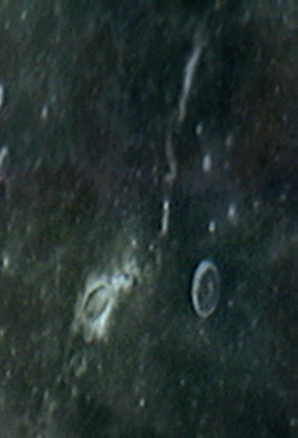
reply to post by kenton1234
So, for you, this
[atsimg]http://files.abovetopsecret.com/files/206d06a8b3963fa8.jpg[/atsimg]
is the same as this?
[atsimg]http://files.abovetopsecret.com/files/5537d55ebeff15f2.jpg[/atsimg]
Don't you see at least a slight difference in image quality and detail (that was what we were talking about)?
Or are you talking about a different thing?
Originally posted by dainoyfb
This may be true I'm no orbital expert. Can you site a source that states that a close orbit or elliptical orbit would be impossible for an imaging mission to the Moon?
Beyond this point even at much higher orbits, higher resolution images have been possible for decades.
I don't think it is impossible, just more expensive and risky.
And yes, higher resolutions have been possible, but wouldn't they need a larger (and, once more, more expensive) craft?
What is wrong with 7 million photos? How many photos are used by Google earth? And thousands more are added by there land vehicles every day. With today's technology I can't see how this is relevant.
The problem is the time it takes. I know that it's not exactly the same thing, but the Mars Orbiter Camera on board Mars Global Surveyor, during its nine years work life sent to Earth "just" more than 240,000 images, while HiRISE, with a resolution of 30 centimetres per pixel has returned only some 10,000 photos since October 2006.
And unless they get a relay satellite that is always "viewing" the other satellite then they can only transmit the data gathered during the half of the orbit that is made with the Earth in view of the satellite.
Also, global surveys could be made at lower magnifications while areas of interest could take advantage of the higher resolutions.
I think that is the best way of doing things, but they would probably need more than one camera for that, although the lower resolution images could be taken with a smaller camera.
Basicaly, I was agreeing with you, the lack of atmosphere means they can get much sharper photos.
I'm not sure what you are trying to point out here, could you rephrase?
Aren't the sensors on the rovers just 1024x1024? That is a field that I haven't been following, so the possibilities of being wrong are even greater than usual.
There are in fact many high resolution imaging chips in space including ones on the Mars rovers, ones that have been running fine on the Hubble Space Telescope for years, ones being implemented on the JWST which will be unreachable for service during its entire mission at the Earth/Moon L2 point.
Can an individual here on Planet Earth locate left over landing crafts, flags, footprints etc of the US Moon landings by using a simple telescope?
new topics
-
Late Night with the Devil - a really good unusual modern horror film.
Movies: 14 minutes ago -
Cats Used as Live Bait to Train Ferocious Pitbulls in Illegal NYC Dogfighting
Social Issues and Civil Unrest: 1 hours ago -
The Good News According to Jesus - Episode 1
Religion, Faith, And Theology: 3 hours ago -
HORRIBLE !! Russian Soldier Drinking Own Urine To Survive In Battle
World War Three: 5 hours ago -
Bobiverse
Fantasy & Science Fiction: 8 hours ago -
Florida man's trip overseas ends in shock over $143,000 T-Mobile phone bill
Social Issues and Civil Unrest: 8 hours ago -
Former Labour minister Frank Field dies aged 81
People: 10 hours ago
top topics
-
President BIDEN Vows to Make Americans Pay More Federal Taxes in 2025 - Political Suicide.
2024 Elections: 17 hours ago, 19 flags -
Florida man's trip overseas ends in shock over $143,000 T-Mobile phone bill
Social Issues and Civil Unrest: 8 hours ago, 8 flags -
SETI chief says US has no evidence for alien technology. 'And we never have'
Aliens and UFOs: 12 hours ago, 7 flags -
Cats Used as Live Bait to Train Ferocious Pitbulls in Illegal NYC Dogfighting
Social Issues and Civil Unrest: 1 hours ago, 4 flags -
Former Labour minister Frank Field dies aged 81
People: 10 hours ago, 4 flags -
Bobiverse
Fantasy & Science Fiction: 8 hours ago, 3 flags -
This is our Story
General Entertainment: 15 hours ago, 3 flags -
HORRIBLE !! Russian Soldier Drinking Own Urine To Survive In Battle
World War Three: 5 hours ago, 2 flags -
Late Night with the Devil - a really good unusual modern horror film.
Movies: 14 minutes ago, 1 flags -
The Good News According to Jesus - Episode 1
Religion, Faith, And Theology: 3 hours ago, 0 flags
active topics
-
-@TH3WH17ERABB17- -Q- ---TIME TO SHOW THE WORLD--- -Part- --44--
Dissecting Disinformation • 650 • : angelchemuel -
Thousands Of Young Ukrainian Men Trying To Flee The Country To Avoid Conscription And The War
Other Current Events • 135 • : twistedpuppy -
President BIDEN Vows to Make Americans Pay More Federal Taxes in 2025 - Political Suicide.
2024 Elections • 89 • : DBCowboy -
Late Night with the Devil - a really good unusual modern horror film.
Movies • 0 • : devilhunter69 -
New whistleblower Jason Sands speaks on Twitter Spaces last night.
Aliens and UFOs • 52 • : 0bserver1 -
SETI chief says US has no evidence for alien technology. 'And we never have'
Aliens and UFOs • 33 • : 0bserver1 -
Mood Music Part VI
Music • 3099 • : BrucellaOrchitis -
HORRIBLE !! Russian Soldier Drinking Own Urine To Survive In Battle
World War Three • 20 • : budzprime69 -
Cats Used as Live Bait to Train Ferocious Pitbulls in Illegal NYC Dogfighting
Social Issues and Civil Unrest • 2 • : Cre8chaos79 -
Florida man's trip overseas ends in shock over $143,000 T-Mobile phone bill
Social Issues and Civil Unrest • 14 • : Raptured