It looks like you're using an Ad Blocker.
Please white-list or disable AboveTopSecret.com in your ad-blocking tool.
Thank you.
Some features of ATS will be disabled while you continue to use an ad-blocker.

The Betty Hill Starmap - New insight
page: 6share:
The original post does a good job in understanding and explaining the importance of stellar distances and spectral types when considering exoplanets.
It also does a good job collecting additional information regarding the sun-like stars allegedly represented in the Fish-Hill star map.
But it is not new, surprising information, since Fish originally set out to include only sun-like stars (mainly G class) in her interpretation. It was known 30+ years ago (e.g. in Planets For Man, Stephen Dole) to look at sun-like, G-class stars for likely solar systems. So it's not surprising that some stars on a forty-year old list of known sun-like stars would in fact, be prime candidates for SETI.
The characteristics of the stars is not the issue. It is the criteria of their selection and their positioning. There are many problems with the Marjorie Fish interpretation. These ones leaps out at me right away.
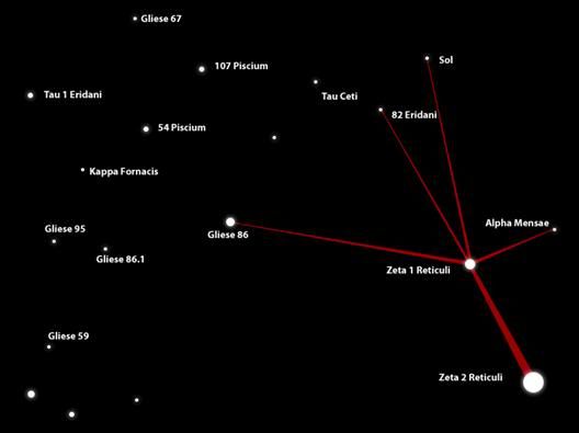
Here for reference, is the Fish-Hill map:
1.
The "leader" never told Betty Hill that what she was looking at included Sol or Zeta Reticuli, but Marjorie Fish simply assumed the sun was represented on the map. That's a huge assumption! Someone has also made the case the map represents the Solar System ( link). Why is one interpretation more favored than the other?
2.
Where are the other prominent, G-class and sun-like stars near Sol in Fish's map? Where is Alpha Centauri, Epsilon Indi, and the rest? Why would a map not include these? It's like having a map of the East Coast of the US showing Philadelphia but not New York or Boston. It's strange.
Here is a 2D projection map showing all of the 'habitable' (G, some K, some F) type stars within a 50 LY radius of Earth:
Look at all of those stars - and those are NOT red dwarfs! Fish's map is about 200 LY wide (Sol to Gliese 86.1), and so actually represents an area LARGER than the above map. There's a lot missing!
3.
Why is Gliese 86.1 included? It is more than 186 light years from Sol. There are more than 500 sun-like stars less than 100 light years from Sol (link). That is like having a map of your East Coast, which shows Philadelphia but not New York, but also shows Honolulu for some reason!
4.
The stars labeled Zeta Reticuli are only about 0.1 Light Years apart in actuality. This map shows a much greater apparent distance between the two, particularly if you compare it to the distance between Zeta Reticula and our Solar System, which is 40 light years. You could argue, "well it's a matter of perspective" - but then you have to admit the map is not drawn to scale. And if it's not drawn to scale, then all bets are off!
It's a stylized, visual representation then, not a map, how could it be taken seriously as a map if it's not to scale? How can you "fit" other stars into a pattern if the distances are not accurate? And the Zeta 1 : Zeta 2 versus Zeta : Sol distances are clearly a mess by many orders of magnitude!
And here's Betty's original map:
It clearly can't be to scale either, or if it is, those two near objects with lines around them cannot be stars, because if they were gravity would have crushed them together billions of years ago. And what kind of stars have vertical bands across them? Stargates? Satellites? Moons? It could be some stylized representation of solar data, but you still have the problem of scale.
I find the Fish map interesting but ultimately unconvincing because of the way stars are chosen to fit a pre-existing pattern - but there is zero assurance of any kind of accuracy given the distances involved in the pattern!
Betty drew a map, from hypnotic regression, five years after the fact, knowing full well she didn't know much about drawing or astronomy. To imagine the distances she drew would be accurate is absurd. To cherry-pick 12 or so stars out of the 500+ Sun-like stars in that volume of space to match a rough hand sketch does not seem statistically improbable at all.
But it is not new, surprising information, since Fish originally set out to include only sun-like stars (mainly G class) in her interpretation. It was known 30+ years ago (e.g. in Planets For Man, Stephen Dole) to look at sun-like, G-class stars for likely solar systems. So it's not surprising that some stars on a forty-year old list of known sun-like stars would in fact, be prime candidates for SETI.
The characteristics of the stars is not the issue. It is the criteria of their selection and their positioning. There are many problems with the Marjorie Fish interpretation. These ones leaps out at me right away.
Here for reference, is the Fish-Hill map:
1.
The "leader" never told Betty Hill that what she was looking at included Sol or Zeta Reticuli, but Marjorie Fish simply assumed the sun was represented on the map. That's a huge assumption! Someone has also made the case the map represents the Solar System ( link). Why is one interpretation more favored than the other?
2.
Where are the other prominent, G-class and sun-like stars near Sol in Fish's map? Where is Alpha Centauri, Epsilon Indi, and the rest? Why would a map not include these? It's like having a map of the East Coast of the US showing Philadelphia but not New York or Boston. It's strange.
Here is a 2D projection map showing all of the 'habitable' (G, some K, some F) type stars within a 50 LY radius of Earth:
Look at all of those stars - and those are NOT red dwarfs! Fish's map is about 200 LY wide (Sol to Gliese 86.1), and so actually represents an area LARGER than the above map. There's a lot missing!
3.
Why is Gliese 86.1 included? It is more than 186 light years from Sol. There are more than 500 sun-like stars less than 100 light years from Sol (link). That is like having a map of your East Coast, which shows Philadelphia but not New York, but also shows Honolulu for some reason!
4.
The stars labeled Zeta Reticuli are only about 0.1 Light Years apart in actuality. This map shows a much greater apparent distance between the two, particularly if you compare it to the distance between Zeta Reticula and our Solar System, which is 40 light years. You could argue, "well it's a matter of perspective" - but then you have to admit the map is not drawn to scale. And if it's not drawn to scale, then all bets are off!
It's a stylized, visual representation then, not a map, how could it be taken seriously as a map if it's not to scale? How can you "fit" other stars into a pattern if the distances are not accurate? And the Zeta 1 : Zeta 2 versus Zeta : Sol distances are clearly a mess by many orders of magnitude!
And here's Betty's original map:
It clearly can't be to scale either, or if it is, those two near objects with lines around them cannot be stars, because if they were gravity would have crushed them together billions of years ago. And what kind of stars have vertical bands across them? Stargates? Satellites? Moons? It could be some stylized representation of solar data, but you still have the problem of scale.
I find the Fish map interesting but ultimately unconvincing because of the way stars are chosen to fit a pre-existing pattern - but there is zero assurance of any kind of accuracy given the distances involved in the pattern!
Betty drew a map, from hypnotic regression, five years after the fact, knowing full well she didn't know much about drawing or astronomy. To imagine the distances she drew would be accurate is absurd. To cherry-pick 12 or so stars out of the 500+ Sun-like stars in that volume of space to match a rough hand sketch does not seem statistically improbable at all.
edit on 9/20/2010 by Nicorette because: broken link
edit on 9/20/2010 by Nicorette because: broken link
Do you have evidence for the "colors" claim? As far I remember the map was done in black and white?
The colors are from Betty's testimony. She stated the lines on the map were between yellow stars like our sun. (I'm fairly certainly there's some sourcing in my post on the Hill case in the sticked thread of classic cases). She also described the other colors she saw in the projection she was shown.
The thing about Sagan's theory, is that when you add the colors to the equation, it all goes to crap, and is more than just random.
[Edited to add:]
As Nicorette says, it is all a matter of interpretation. Now what I'm going to try here is to give reasons why her interpretation cannot be as bad as some may think. Actually, and based on many logical arguments, her interpretation is by far the best I've seen, and I'll even add that there is no other interpretation that's based on any logical arguments.
In particular, interpretations like the "planets around the sun" map has been proposed, but no one has ever tried to justify it as being better than any other.
I am going to try to justify the fact that the interpretation given by Marjorie Fish, not only makes perfect sense, but also is not just a "lucky pick out of many other places where stars are arranged in the same way" like Sagan or others have suggested.
[End of edit]
As the story goes, the leader would have apparently asked her if she could locate herself on the map he was showing her, which leads me to believe that assuming the sun would actually be on that map is a bit more than a working hypothesis. It would make less than no sense to ask someone to pinpoint their location on a map that doesn't contain their position.
Besides, the reason why I would say that the solar system map is less credible is simple: stars, even if they are all actually moving, are separated by large distances, and thus their relative position to each other varies very little over long periods of time. This makes a star map a pretty much "permanent" map, while on the contrary, planets around a single star (and hence, our solar system as well) are comparatively moving much faster, making a "planet map" very short lived.
That being said, it's not idiot to suppose either that the map they have shown could well be a "3D real time" map of the solar system at the present time, we even can do that now, so no wonder a civilisation able to travel stars could do it too. As I said, it is merely about assuming, indeed, but to me, it makes more sense, simply.
It is human by nature to try and get back things compared to what we know, and that's why it is particularly difficult to deal with ufology at large because it includes so many things that are beyond comparison. With this in mind, the comparison I'll be trying to make is maybe easily dismissable, but just as well credible too for the reason that we simply don't know if they could be indeed very similar to us or not.
Let's assume that we are visiting a place where a species live, a species that we thing is potentially intelligent, sentient. We're not exactly sure what they are and even where in the evolution process they are, but we're giving it a try: let's show them a map of earth and let's see if they can 1. recognize the place where we all live, and 2. pinpoint their location on that planet.
This being taken at "the correct scale" (i.e. assuming they are coming from some "distant" star), it makes full sense to show a map of neighbouring stars, and ask if they know where they are. More sense, I think, than showing the planets around the sun and ask them which planet they're on.
Sorry, it says permission denied on that server.
This may be a misinterpretation. However, depending on the role or use that one makes of a map, not everything is included.
Someone said something like "when you draw a map, you don't only place a dot on it for major cities". Well, yes: one does place a dot only for major cities. Not all villages are plotted. Actually, most are not. And again, depending on the use of the map, you may well only plot just your "places of interest". If, if that was indeed a "trade routes" map, then it may be perfectly normal to have only those stars on it, and not the rest. After all, what do we know of their trading business?
No. We simply don't know what kind of scale can be used in such a map. Actually, that model was supposed to be in 3D, and it could be presented on a 3D logarithmic scale, which would make closer objects very much bigger than those in the distance. That's actually how it looks like on the drawing: the "balls" are much bigger where they are supposed to be "close". Hence, the distance between the two objects close to you and those further away can be much larger even though it represents a much shorter one on a 1:1 scale (or at least on any linear scale).
That magnitude problem would be solved by my proposition here above. Add to it that drawing depth on a 2D sheet of paper can be achieved by largely exagerating proportions on the "front" plane and reducing them on the "far behind" plane.
Well again, it could be a logarithmic scale. Now, having the two main stars represented as bigger than they should be is not out of logic either. Most, if not all, of the 3D animations I've seen being used to teach about solar system, moon-earth, etc. are actually using immensely exagerated sizes, i.e. not to scale. If it had to be all done to scale, then you'd see a totally black screen with a white dot here, and a blue one there on the other corner, and nothing at all in between. That wouldn't be very practical at all.
About those lines, let's think again that the map is supposed to show trade routes. Now, get a map of the metro of London (or any other city for the purpose, that will do). See how many thick lines are between major stations of the center? That can't be to scale, can it?
See the area roughly in between Baker st, Liverpool st, Kennington & Earl's court. Well, that's the kind of things we have when drawing many major routes on a map. They come to cover more surface than in real. Representing many major trade routes in between their 2 "home worlds" would quite likely be done in such a way.
That is the argument that Sagan has used to dismiss the map. However, one must remember that:
So, in summary, the map was not drawn "to fit a pre-existing pattern", and the model was not either "built to fit a pre-existing pattern".
Let's take a similar example.
Imagine now that I'd pick a particular area of a major city, from a map, and keep only major streets, removing from the map all the little streets in between, the dead-ends in between buildings, etc. Now you'd have in front of you a map. A map from a place that exists. Let's now suppose that I'd go into that particular city.
To push the comparison (Betty knew nothing of astronomy), I'd ask, not to a taxi driver, but anyone on the street "excuse me there, can you tell me where we are ?" and show them that map. Let's then suppose we have there someone who doesn't know the city. He can't tell me of course, but he's looking well at the map, in hope he can make something out of it.
But now, if he draws himself the map I showed him, it will of course more or less look like the real map. What is the chance that someone who knows well cities and their maps (i.e. Marjorie Fish knew about astronomy!) would identify some place that's wrong, knowing that the person who drew it said "someone asked me where they were" in that particular city? Don't you think that, of course, you'd start by trying to find that place, or a place that looks much like the drawing, from that particular city? You wouldn't want to pick another city, would you?
And thus, eventually, after looking many hours at the map, distorting it a bit, etc., you find that there is a particular section on the actual map of the city that matches well the drawing. Oh yeah, there are many other streets there, and the drawing shows none. But were those streets important to the visitor? Hmm... I don't think they were.
Well it doesn't seem improbable at all, statistically, that I'd win a big thing on the lottery either. However, I'd have to play for many, many years before the chances start to become just a bit more than amazing luck.
I invite anyone who really wants to try that, to "cherry-pick 12 or so stars" out of the 500+ sun-like around us and be any close to what the drawing looks like. Maybe less improbable than winning the lottery, but again the work that Marjorie Fish did was not about finding what she wanted to find, or finding something that matched a pre-existing pattern
She based her work on very reasonable hypothesis, and spent a long time before spotting what had to be spotted. If it were so probable that the same pattern (or a similar looking one anyway) would be found easily anywhere else, then I have to assume that for the sake of finding it and dismissing the whole case, then someone would have done it already now, for a long time! Sadly for those who think that it is easy to do, no one yet has found anything like that.
As Nicorette says, it is all a matter of interpretation. Now what I'm going to try here is to give reasons why her interpretation cannot be as bad as some may think. Actually, and based on many logical arguments, her interpretation is by far the best I've seen, and I'll even add that there is no other interpretation that's based on any logical arguments.
In particular, interpretations like the "planets around the sun" map has been proposed, but no one has ever tried to justify it as being better than any other.
I am going to try to justify the fact that the interpretation given by Marjorie Fish, not only makes perfect sense, but also is not just a "lucky pick out of many other places where stars are arranged in the same way" like Sagan or others have suggested.
[End of edit]
Originally posted by Nicorette
1.
The "leader" never told Betty Hill that what she was looking at included Sol or Zeta Reticuli, but Marjorie Fish simply assumed the sun was represented on the map. That's a huge assumption! Someone has also made the case the map represents the Solar System ( link). Why is one interpretation more favored than the other?
As the story goes, the leader would have apparently asked her if she could locate herself on the map he was showing her, which leads me to believe that assuming the sun would actually be on that map is a bit more than a working hypothesis. It would make less than no sense to ask someone to pinpoint their location on a map that doesn't contain their position.
Besides, the reason why I would say that the solar system map is less credible is simple: stars, even if they are all actually moving, are separated by large distances, and thus their relative position to each other varies very little over long periods of time. This makes a star map a pretty much "permanent" map, while on the contrary, planets around a single star (and hence, our solar system as well) are comparatively moving much faster, making a "planet map" very short lived.
That being said, it's not idiot to suppose either that the map they have shown could well be a "3D real time" map of the solar system at the present time, we even can do that now, so no wonder a civilisation able to travel stars could do it too. As I said, it is merely about assuming, indeed, but to me, it makes more sense, simply.
It is human by nature to try and get back things compared to what we know, and that's why it is particularly difficult to deal with ufology at large because it includes so many things that are beyond comparison. With this in mind, the comparison I'll be trying to make is maybe easily dismissable, but just as well credible too for the reason that we simply don't know if they could be indeed very similar to us or not.
Let's assume that we are visiting a place where a species live, a species that we thing is potentially intelligent, sentient. We're not exactly sure what they are and even where in the evolution process they are, but we're giving it a try: let's show them a map of earth and let's see if they can 1. recognize the place where we all live, and 2. pinpoint their location on that planet.
This being taken at "the correct scale" (i.e. assuming they are coming from some "distant" star), it makes full sense to show a map of neighbouring stars, and ask if they know where they are. More sense, I think, than showing the planets around the sun and ask them which planet they're on.
2.
Sorry, it says permission denied on that server.
3.
Why is Gliese 86.1 included? It is more than 186 light years from Sol. There are more than 500 sun-like stars less than 100 light years from Sol (link). That is like having a map of your East Coast, which shows Philadelphia but not New York, but also shows Honolulu for some reason!
This may be a misinterpretation. However, depending on the role or use that one makes of a map, not everything is included.
Someone said something like "when you draw a map, you don't only place a dot on it for major cities". Well, yes: one does place a dot only for major cities. Not all villages are plotted. Actually, most are not. And again, depending on the use of the map, you may well only plot just your "places of interest". If, if that was indeed a "trade routes" map, then it may be perfectly normal to have only those stars on it, and not the rest. After all, what do we know of their trading business?
4.
The stars labeled Zeta Reticuli are only about 0.1 Light Years apart in actuality. This map shows a much greater apparent distance between the two, particularly if you compare it to the distance between Zeta Reticula and our Solar System, which is 40 light years. You could argue, "well it's a matter of perspective" - but then you have to admit the map is not drawn to scale. And if it's not drawn to scale, then all bets are off!
No. We simply don't know what kind of scale can be used in such a map. Actually, that model was supposed to be in 3D, and it could be presented on a 3D logarithmic scale, which would make closer objects very much bigger than those in the distance. That's actually how it looks like on the drawing: the "balls" are much bigger where they are supposed to be "close". Hence, the distance between the two objects close to you and those further away can be much larger even though it represents a much shorter one on a 1:1 scale (or at least on any linear scale).
It's a stylized, visual representation then, not a map, how could it be taken seriously as a map if it's not to scale? How can you "fit" other stars into a pattern if the distances are not accurate? And the Zeta 1 : Zeta 2 versus Zeta : Sol distances are clearly a mess by many orders of magnitude!
That magnitude problem would be solved by my proposition here above. Add to it that drawing depth on a 2D sheet of paper can be achieved by largely exagerating proportions on the "front" plane and reducing them on the "far behind" plane.
And here's Betty's original map:
It clearly can't be to scale either, or if it is, those two near objects with lines around them cannot be stars, because if they were gravity would have crushed them together billions of years ago. And what kind of stars have vertical bands across them? Stargates? Satellites? Moons? It could be some stylized representation of solar data, but you still have the problem of scale.
Well again, it could be a logarithmic scale. Now, having the two main stars represented as bigger than they should be is not out of logic either. Most, if not all, of the 3D animations I've seen being used to teach about solar system, moon-earth, etc. are actually using immensely exagerated sizes, i.e. not to scale. If it had to be all done to scale, then you'd see a totally black screen with a white dot here, and a blue one there on the other corner, and nothing at all in between. That wouldn't be very practical at all.
About those lines, let's think again that the map is supposed to show trade routes. Now, get a map of the metro of London (or any other city for the purpose, that will do). See how many thick lines are between major stations of the center? That can't be to scale, can it?
See the area roughly in between Baker st, Liverpool st, Kennington & Earl's court. Well, that's the kind of things we have when drawing many major routes on a map. They come to cover more surface than in real. Representing many major trade routes in between their 2 "home worlds" would quite likely be done in such a way.
I find the Fish map interesting but ultimately unconvincing because of the way stars are chosen to fit a pre-existing pattern - but there is zero assurance of any kind of accuracy given the distances involved in the pattern!
That is the argument that Sagan has used to dismiss the map. However, one must remember that:
- When Betty drew the map, she was pretty much convinced that those were stars, but she had no idea that stars could be of F, G, K or any type. She
knew nothing of astronomy.
- What Fish has actually done, is to reduce the number of stars in the whole mass around us to just and only those that would somehow "make sense".
Removing, at first, all those that are not F, G or K, thus, makes total sense.
- When finding a pattern that resembled what Betty had drawn, removing the rest around, once again, makes perfect sense.
So, in summary, the map was not drawn "to fit a pre-existing pattern", and the model was not either "built to fit a pre-existing pattern".
Let's take a similar example.
Imagine now that I'd pick a particular area of a major city, from a map, and keep only major streets, removing from the map all the little streets in between, the dead-ends in between buildings, etc. Now you'd have in front of you a map. A map from a place that exists. Let's now suppose that I'd go into that particular city.
To push the comparison (Betty knew nothing of astronomy), I'd ask, not to a taxi driver, but anyone on the street "excuse me there, can you tell me where we are ?" and show them that map. Let's then suppose we have there someone who doesn't know the city. He can't tell me of course, but he's looking well at the map, in hope he can make something out of it.
But now, if he draws himself the map I showed him, it will of course more or less look like the real map. What is the chance that someone who knows well cities and their maps (i.e. Marjorie Fish knew about astronomy!) would identify some place that's wrong, knowing that the person who drew it said "someone asked me where they were" in that particular city? Don't you think that, of course, you'd start by trying to find that place, or a place that looks much like the drawing, from that particular city? You wouldn't want to pick another city, would you?
And thus, eventually, after looking many hours at the map, distorting it a bit, etc., you find that there is a particular section on the actual map of the city that matches well the drawing. Oh yeah, there are many other streets there, and the drawing shows none. But were those streets important to the visitor? Hmm... I don't think they were.
Betty drew a map, from hypnotic regression, five years after the fact, knowing full well she didn't know much about drawing or astronomy. To imagine the distances she drew would be accurate is absurd. To cherry-pick 12 or so stars out of the 500+ Sun-like stars in that volume of space to match a rough hand sketch does not seem statistically improbable at all.
Well it doesn't seem improbable at all, statistically, that I'd win a big thing on the lottery either. However, I'd have to play for many, many years before the chances start to become just a bit more than amazing luck.
I invite anyone who really wants to try that, to "cherry-pick 12 or so stars" out of the 500+ sun-like around us and be any close to what the drawing looks like. Maybe less improbable than winning the lottery, but again the work that Marjorie Fish did was not about finding what she wanted to find, or finding something that matched a pre-existing pattern
She based her work on very reasonable hypothesis, and spent a long time before spotting what had to be spotted. If it were so probable that the same pattern (or a similar looking one anyway) would be found easily anywhere else, then I have to assume that for the sake of finding it and dismissing the whole case, then someone would have done it already now, for a long time! Sadly for those who think that it is easy to do, no one yet has found anything like that.
edit on 21-9-2010 by SpookyVince because: Added some sort of introduction to the post
Originally posted by SpookyVince
Sorry, it says permission denied on that server.
Just copy the address and paste it on another browser window or tab, that server probably does not allow direct linking.
I know this is about the Hill star map but if this guy is right (and I think he nailed it) then any questions about the alleged star map are moot:
nielsenhayden.com...
And here's a more general page:
www.theironskeptic.com...
nielsenhayden.com...
And here's a more general page:
www.theironskeptic.com...
Why is this map sighted as strong evidence?
If you take a 3d plane, like space, flatten it into a 2d map, and then add stars, and there are millions of them, does it not just become a matter of connecting the dots?
You could take any section of the sky, flatten it and connect a series of dots until it resembled a 2d equivalence of the betty map.
reply to post by NavalFC
Infact, you should do this: download a program called stellarium. Its a astronomy program, and set its map to display all stars regardless of magnitude. Look at the countless number of stars there are. Now, take the betty hill map and you can see you can make that pattern almost anywhere in the sky. Almost ANYWHERE.
Why? because space is 3d, yet betty hill presented a 2d map, on a flattened plane, liken to the program above.
I find it utterly fallacious how anyone can call that an exact match, given the circumstances.
To be able to take a 2d map that has no distances nor scales, no refrences no nothing and presume to be able to match it up to one and only 1 spot in the universe? Really?
Secondly there are no distances, no nothing, so you havent a clue how far the distance is in between each object even if it were a map.
Also, according to betty hill, the map represented stars and planets and other objects. Your using just stars, so it doesnt even match her account
edit on 22-9-2010 by NavalFC because: (no reason given)
reply to post by NavalFC
Firstly, if you have any astronomical culture or knowledge, or at least if you have read that actually ALL the stars identified in the map are situated on the same plane (more or less), then you must realize how actually near impossible it is to, as you claim, find the same pattern "everywhere". Show me where you see it everywhere else please, I have not found.
Secondly, if you have had any curiosity about how drawing a 3D thing on a 2D paper is done, then you must know what perspective is. So of course, she presented a 2D drawing, on a 2D paper. Actually, 3D paper had not been invented yet back then.
Finally, and I must quote you:
Well...
I know that you clearly consider that map a topic of non interest. That's your view. Mine is that it is interesting and realistically interpreted. But if you are going to try to tell me "listen pal, it's bull...t", then you are going to have to use better arguments.
To see this in a light spirited way, your job is to convince me that I'm wrong, but mine is to convince you that I'm right. It's not the same thing. I'm trying to build a thing out of stuff, you're trying to blow out my building into parts... You're not trying to build anything next to mine and say "look, mine is better".
This kind of topic is clearly one of "feelings", "interpretations", "subjective views" etc. However, as I said, all that I'm basing my views on seems totally reasonable, and besides, I've never said "I tell what IS the reality". I think it must be, to a high degree of certainty, true, however chances exist that something is either biased, unknown, wrongly assessed, hidden, or otherwise out of place, and thus that my interpretation could be wrong too.
Nobody has given me any element of proof that what I'm assuming is wrong. There were just a few other hypothesis offered, but so far no one has either been trying or been successful at showing me something that's clearly wrong.
I'm still waiting, for instance, for ANY proof that a 3D configuration of some stars, anywhere else, could just as well look as close as Betty's map like the one that Marjorie Fish has spotted.
Firstly, if you have any astronomical culture or knowledge, or at least if you have read that actually ALL the stars identified in the map are situated on the same plane (more or less), then you must realize how actually near impossible it is to, as you claim, find the same pattern "everywhere". Show me where you see it everywhere else please, I have not found.
Secondly, if you have had any curiosity about how drawing a 3D thing on a 2D paper is done, then you must know what perspective is. So of course, she presented a 2D drawing, on a 2D paper. Actually, 3D paper had not been invented yet back then.
Finally, and I must quote you:
To be able to take a 2d map that has no distances nor scales, no refrences no nothing and presume to be able to match it up to one and only 1 spot in the universe? Really?
Well...
- no distance or scale is exact, no reference and no nothing is inexact. It was supposed to be "a trade routes" map, and it was supposed to include
at least the sun or the earth (depending on which interpretation you favour)
- it was not about presuming to be able to match it up to anything, it was about trying to figure out if any existing configuration of "objects"
(let's take it at large) was possibly looking like it
- nobody has ever said that it would be the only spot in the universe. In fact there may be many other places indeed, however, there has been only 1
that has been found using all the logical criteria derived from reasonable assumptions, given circumstances, i.e. a neighbourhood of us, habitable
systems, presumably close distances (cosmologically speaking, it's a pinhead...)
I know that you clearly consider that map a topic of non interest. That's your view. Mine is that it is interesting and realistically interpreted. But if you are going to try to tell me "listen pal, it's bull...t", then you are going to have to use better arguments.
To see this in a light spirited way, your job is to convince me that I'm wrong, but mine is to convince you that I'm right. It's not the same thing. I'm trying to build a thing out of stuff, you're trying to blow out my building into parts... You're not trying to build anything next to mine and say "look, mine is better".
This kind of topic is clearly one of "feelings", "interpretations", "subjective views" etc. However, as I said, all that I'm basing my views on seems totally reasonable, and besides, I've never said "I tell what IS the reality". I think it must be, to a high degree of certainty, true, however chances exist that something is either biased, unknown, wrongly assessed, hidden, or otherwise out of place, and thus that my interpretation could be wrong too.
Nobody has given me any element of proof that what I'm assuming is wrong. There were just a few other hypothesis offered, but so far no one has either been trying or been successful at showing me something that's clearly wrong.
I'm still waiting, for instance, for ANY proof that a 3D configuration of some stars, anywhere else, could just as well look as close as Betty's map like the one that Marjorie Fish has spotted.
reply to post by SpookyVince
This was such a good thread and OP that it's worth bumping.
The Barney and Betty Hill story is available as an audiobook narrated by Whitley Strieber. The first half is all narrative/story and the last half is the real hypnosis tapes of Barney and Betty.
Right click and save as...www.noufors.com...
The NOUFORS site is well worth a visit too...www.noufors.com...
Upon further reflection, it seems to me that if an alien has a 3-D star map, then it would probably act more like the GPS road map devices we have
these days for our cars. It would automatically move and rotate and align itself according to where the ship was, and not just be stuck in one spot
highlighting its home planet. If you were on Earth, the largest "dot" would be Earth, not Zeta Reticuli. This kind of thing wouldn't be thought
of by people 50 years ago, who were used to their maps from gas stations staying still.
So if it was the case that the map automatically shifted according to the position of the ship, the large, closest dot would be the Earth, and the next large dot with all the lines going to it would probably be the Moon. Knowing the date and time that the alien showed the map to Betty Hill would give you a rough idea as to how the Earth and Moon were aligned at that time, and provide you with the proper perspective from which you could perhaps map out the rest of the stars, planets or outposts. Look at it as if it were a regular 3-D representation of you looking from some point in space (a LaGrange Point, maybe?) at the Earth, Moon, and everything in that direction.
I'm not to good with astronomy programs, but I'll see what I can come up with. Anybody else want to give this a try, or maybe find out where the Moon (and the rest of the planets) was relative to the Earth on the night of September 19, 1961, maybe around midnight?
I saw this thread had been bumped again, for which I'm glad, because I hadn't before seen SpookyVince's extensive reply to my earlier case against the
Hill-Fish starmap. I thank him for taking the time to so carefully address my arguments. This is my answer.
Granted, it's logical to you or me. But you are attributing human logic to supposed alien beings. Maybe it amuses them to lie. Maybe they are protecting their homeworld. Maybe it was a psychological test to a series of random points of light. There is not enough information to make this assumption. But for the sake of argument, which I will elaborate below, I will include Sol in an alternative interpretation.
Agreed.
Or, since we can freely enter their atmosphere and remove people from their cars, receive their television and radio broadcasts, etc., we could also go to the local library and check out a book on astronomy, or better yet, abduct an actual astronomer, rather than a New England housewife from the 1950s, if we are serious about gauging the astronomical knowledge of this species. Again, we are imputing human logic onto purported alien beings. That's unsupportable. This line of argument doesn't hold up.
Against my objection of Marjorie Fish inluding Gliese 86.1 in her starmap, even though it is 186 light years from Sol and there are more than 500 sun-like stars less than 100 light years from Sol:
That is a serious misinterpretation then, because that star doesn't fit the rest of the proposed data. It's an outlier. In fact, as I will show in my "interpretation" below, even Zeta Reticuli can be considered too far away, since if you were making any sort of star map showing only G-class and similar stars which includes Sol and only has ten or so systems on the map, then there are dozens of other candidates before you would include Zeta Reticuli.
That's not what I said. I said the map shows Philadelphia but not New York. New York is not a village. In the Galactic neighborhood, when searching for planets that can support life, we can consider red dwarfs as 'villages.' Alpha Centauri, Delta Pavonis, Zeta Tucanae, Epsilon Eridani - these are not dwarfs, nor villages. These are major potentially planet-bearing stars all within the solar neighborhood and much closer than Zeta Reticuli, which would be strange to omit from any starmap, human or otherwise. They are not on Fish's map.
Against my objection that the Zeta Reticuli binaries are only about .01 Light Years apart, while this map shows a greater distance if you compare it to the Sol-Zeta distance of some 40 LY, Vince writes:
What is the cognitive difference from our point of view if the map is either not drawn to scale, or drawn in such a perspective (and potentially stylized and simplified like a London subway map) in 3D that without reference points? In either case, we cannot back-engineer the map, particularly given the source is a 2D map drawn from hypnotic memory? In either case, we are forced to admit the "map" is essentially useless, and trying to locate and name individual stars on a map is in no way scientific.
To my objection that if the distances between Zeta 1:2 do not correspond to Zeta:Sol, then the whole map is useless since it's not to scale, he writes:
But it's not solved at all. The only thing you are offering is an alternate explanation why the original hand-drawn map looks so strange - because it's not a 2D overhead perspective map, it's a 3D planar view. That only offers an additional layer of complication, another axis of scale which we don't know the measurement of. Saying that it "could be" a logarithmic scale only invalidates Fish's interpretation, doesn't it? Because she made no such mention of that effect in her paper, that I am aware of.
It is only Fish who alleged that the stars could only be F, G, K. That was the basis of her inquiry. It's a reasonable hypothesis, but she didn't prove it. Re-stating Fish's hypothesis in this way does not make it so. Betty's knowledge is irrelevant to Fish's ipso facto hypothesis.
In other words: Saying that Betty drew only F, G, K stars without realizing it, when it is merely Fish's hypothesis that she only drew F, G, K stars (as opposed to say, random dots on a piece of paper), does not mean that Betty drew only F, G, K stars instead of random dots on a paper!
As I explained in my original post, Fish ignored hundreds upon hundreds of other F, G, K stars that are closer to Sol than Gliese 86.1. That map I linked to in my earlier post shows only 25% of them. If you super-imposed Fish's map on a local starmap, it would be grossly distorted and in no way resembled either her own map or Betty's piece of paper.
I have accepted your challenge. Judge for yourself, below.
Now you might object, well how can this be done so quickly, what took Marjorie Fish many long months? In the 1970s, she didn't have computers, the Internet or PhotoShop. I am in no way saying this is anything close to the painstaking detail she took, but I am saying that it didn't take very long looking at a starmap of our local neighborhood to match a pattern approximating the hand-drawn sketch produced by Betty Hill. And given - as we have extensively discussed - that Hill's map is not to scale and possibly projected on a 3D plane, I think my interpretation is less erroneous than Fish's.
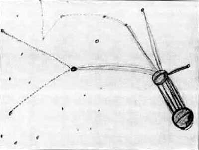
Here is Betty's hand-drawn sketch:
Here is Marjorie Fish's interpretation of the sketch:
Here is a link the local starmap I used (same as in the previous post):
Here is my interpretation of the Fish data set:
And for fun, my labels on the original Hill sketch:
NOTES:
* I used only G & K stars (not even F)
* All my picks are well within 25 LY of Sol, nothing like the 150+ LY extremes found on Fish's map
* My map doesn't fit perfectly, but neither does Fish's
I would only ask any argument used against my interpretation be used against the Fish-Hill starmap, as well.
Lotteries are a tax on those who can't do math!
Originally posted by SpookyVinceb: As the story goes, the leader would have apparently asked her if she could locate herself on the map he was showing her, which leads me to believe that assuming the sun would actually be on that map is a bit more than a working hypothesis. It would make less than no sense to ask someone to pinpoint their location on a map that doesn't contain their position.
Granted, it's logical to you or me. But you are attributing human logic to supposed alien beings. Maybe it amuses them to lie. Maybe they are protecting their homeworld. Maybe it was a psychological test to a series of random points of light. There is not enough information to make this assumption. But for the sake of argument, which I will elaborate below, I will include Sol in an alternative interpretation.
Besides, the reason why I would say that the solar system map is less credible is simple: stars, even if they are all actually moving, are separated by large distances, and thus their relative position to each other varies very little over long periods of time. This makes a star map a pretty much "permanent" map, while on the contrary, planets around a single star (and hence, our solar system as well) are comparatively moving much faster, making a "planet map" very short lived...
Agreed.
Let's assume that we are visiting a place where a species live, a species that we thing is potentially intelligent, sentient. We're not exactly sure what they are and even where in the evolution process they are, but we're giving it a try: let's show them a map of earth and let's see if they can 1. recognize the place where we all live, and 2. pinpoint their location on that planet...it makes full sense to show a map of neighbouring stars, and ask if they know where they are. More sense, I think, than showing the planets around the sun and ask them which planet they're on.
Or, since we can freely enter their atmosphere and remove people from their cars, receive their television and radio broadcasts, etc., we could also go to the local library and check out a book on astronomy, or better yet, abduct an actual astronomer, rather than a New England housewife from the 1950s, if we are serious about gauging the astronomical knowledge of this species. Again, we are imputing human logic onto purported alien beings. That's unsupportable. This line of argument doesn't hold up.
Against my objection of Marjorie Fish inluding Gliese 86.1 in her starmap, even though it is 186 light years from Sol and there are more than 500 sun-like stars less than 100 light years from Sol:
This may be a misinterpretation. However, depending on the role or use that one makes of a map, not everything is included.
That is a serious misinterpretation then, because that star doesn't fit the rest of the proposed data. It's an outlier. In fact, as I will show in my "interpretation" below, even Zeta Reticuli can be considered too far away, since if you were making any sort of star map showing only G-class and similar stars which includes Sol and only has ten or so systems on the map, then there are dozens of other candidates before you would include Zeta Reticuli.
Someone said something like "when you draw a map, you don't only place a dot on it for major cities". Well, yes: one does place a dot only for major cities. Not all villages are plotted. Actually, most are not. And again, depending on the use of the map, you may well only plot just your "places of interest". If, if that was indeed a "trade routes" map, then it may be perfectly normal to have only those stars on it, and not the rest. After all, what do we know of their trading business?
That's not what I said. I said the map shows Philadelphia but not New York. New York is not a village. In the Galactic neighborhood, when searching for planets that can support life, we can consider red dwarfs as 'villages.' Alpha Centauri, Delta Pavonis, Zeta Tucanae, Epsilon Eridani - these are not dwarfs, nor villages. These are major potentially planet-bearing stars all within the solar neighborhood and much closer than Zeta Reticuli, which would be strange to omit from any starmap, human or otherwise. They are not on Fish's map.
Against my objection that the Zeta Reticuli binaries are only about .01 Light Years apart, while this map shows a greater distance if you compare it to the Sol-Zeta distance of some 40 LY, Vince writes:
No. We simply don't know what kind of scale can be used in such a map. Actually, that model was supposed to be in 3D, and it could be presented on a 3D logarithmic scale, which would make closer objects very much bigger than those in the distance. That's actually how it looks like on the drawing: the "balls" are much bigger where they are supposed to be "close". Hence, the distance between the two objects close to you and those further away can be much larger even though it represents a much shorter one on a 1:1 scale (or at least on any linear scale).
What is the cognitive difference from our point of view if the map is either not drawn to scale, or drawn in such a perspective (and potentially stylized and simplified like a London subway map) in 3D that without reference points? In either case, we cannot back-engineer the map, particularly given the source is a 2D map drawn from hypnotic memory? In either case, we are forced to admit the "map" is essentially useless, and trying to locate and name individual stars on a map is in no way scientific.
To my objection that if the distances between Zeta 1:2 do not correspond to Zeta:Sol, then the whole map is useless since it's not to scale, he writes:
That magnitude problem would be solved by my proposition here above. Add to it that drawing depth on a 2D sheet of paper can be achieved by largely exagerating proportions on the "front" plane and reducing them on the "far behind" plane.
But it's not solved at all. The only thing you are offering is an alternate explanation why the original hand-drawn map looks so strange - because it's not a 2D overhead perspective map, it's a 3D planar view. That only offers an additional layer of complication, another axis of scale which we don't know the measurement of. Saying that it "could be" a logarithmic scale only invalidates Fish's interpretation, doesn't it? Because she made no such mention of that effect in her paper, that I am aware of.
1. When Betty drew the map, she was pretty much convinced that those were stars, but she had no idea that stars could be of F, G, K or any type. She knew nothing of astronomy.
It is only Fish who alleged that the stars could only be F, G, K. That was the basis of her inquiry. It's a reasonable hypothesis, but she didn't prove it. Re-stating Fish's hypothesis in this way does not make it so. Betty's knowledge is irrelevant to Fish's ipso facto hypothesis.
In other words: Saying that Betty drew only F, G, K stars without realizing it, when it is merely Fish's hypothesis that she only drew F, G, K stars (as opposed to say, random dots on a piece of paper), does not mean that Betty drew only F, G, K stars instead of random dots on a paper!
2. What Fish has actually done, is to reduce the number of stars in the whole mass around us to just and only those that would somehow "make sense". Removing, at first, all those that are not F, G or K, thus, makes total sense.
As I explained in my original post, Fish ignored hundreds upon hundreds of other F, G, K stars that are closer to Sol than Gliese 86.1. That map I linked to in my earlier post shows only 25% of them. If you super-imposed Fish's map on a local starmap, it would be grossly distorted and in no way resembled either her own map or Betty's piece of paper.
I invite anyone who really wants to try that, to "cherry-pick 12 or so stars" out of the 500+ sun-like around us and be any close to what the drawing looks like. Maybe less improbable than winning the lottery, but again the work that Marjorie Fish did was not about finding what she wanted to find, or finding something that matched a pre-existing pattern
She based her work on very reasonable hypothesis, and spent a long time before spotting what had to be spotted. If it were so probable that the same pattern (or a similar looking one anyway) would be found easily anywhere else, then I have to assume that for the sake of finding it and dismissing the whole case, then someone would have done it already now, for a long time! Sadly for those who think that it is easy to do, no one yet has found anything like that.
I have accepted your challenge. Judge for yourself, below.
Now you might object, well how can this be done so quickly, what took Marjorie Fish many long months? In the 1970s, she didn't have computers, the Internet or PhotoShop. I am in no way saying this is anything close to the painstaking detail she took, but I am saying that it didn't take very long looking at a starmap of our local neighborhood to match a pattern approximating the hand-drawn sketch produced by Betty Hill. And given - as we have extensively discussed - that Hill's map is not to scale and possibly projected on a 3D plane, I think my interpretation is less erroneous than Fish's.
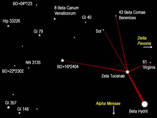
Here is Betty's hand-drawn sketch:
Here is Marjorie Fish's interpretation of the sketch:
Here is a link the local starmap I used (same as in the previous post):
Here is my interpretation of the Fish data set:
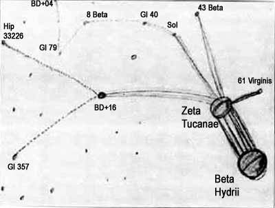
And for fun, my labels on the original Hill sketch:
NOTES:
* I used only G & K stars (not even F)
* All my picks are well within 25 LY of Sol, nothing like the 150+ LY extremes found on Fish's map
* My map doesn't fit perfectly, but neither does Fish's
I would only ask any argument used against my interpretation be used against the Fish-Hill starmap, as well.
Well it doesn't seem improbable at all, statistically, that I'd win a big thing on the lottery either. However, I'd have to play for many, many years before the chances start to become just a bit more than amazing luck.
Lotteries are a tax on those who can't do math!
edit on 11/20/2010 by Nicorette because: typo
edit on 11/20/2010 by Nicorette because: typos
Blue Shift, that's a very interesting point of view. Thanks for your idea!
Nicorette, I've just finished reading your reply, and I must say a real and sincere thank you for your work.
I do not, now, have any time to digest your post entirely or actually make any sort of reply like I would like to, but I promise to give it a much better look in the close future.
I challenged, and you came back with an extremely interesting reply.
Just out of quick reading (and I may have to change that later ) I'd say that you may indeed have a much better explanation of the map. It does not dismiss at all the case, it brings it back with another explanation to go into, which is just great, and which is something I'll be very happy about!
I must go for now, but I will come back Thanks again for your time, trust me that I appreciate sincerely.
This is a bump.
To keep it from being a shameless, gratuitous bump, I'll throw two cents more into the kitty.
I just read Stanton Friedman's chapter on the Hill map "analysis" in his recent book "Captured!". I have to say. for a physicist, I would have expected more analysis and critical thought, and less credulity. He seems to fall right in with the party line, unquestioningly, going so far as to make spurious claims and tenuous connections in order to support the Fish interpretation.
To be perfectly honest, I believe the map to be genuine. That said, I have problems with the Fish interpretation. I'll throw in two of the bigger ones here:
1) the two largest objects, the ones that Fish labels zet1 and zet2 Reticuli, are very clearly NOT stars at all in the original Hill drawing. It can be seen just a bit above this post on this very page. Stars are self-luminous bodies. They do NOT exhibit a crescent phase as is clearly shown on those objects in that drawing. I pointed that out to Friedman on a radio show not long after this book came out, where he was promoting it, but got cut off right after he said "I can't see that". Can't see that? Look for yourselves, right above. They clearly show a crescent phase, as is done by solid planetary bodies, NOT self-luminous stars.
Those objects are planets or moons, and as such will not figure properly into ANY star map interpretation that shows them as stars. They look to me like a double-planet configuration, similar to Pluto/Charon, or as was postulated in Robert Forward's "Rocheworld" series.
2) If you take the two maps, Hill's and Fish's, and REMOVE THE LINES, all resemblance between the two goes right out the window. Without those lines to lead the eye, there is no resemblance whatsoever.
Kudos to Nicorette for adding 43 com/ Beta Comae Berenices into her interpretation. You're getting closer.
For those interested in pursuing this search further, I'll offer these suggestions:
1) remove those planetary bodies from the pattern before you try to match it. As yet, the science of discovering extrasolar planets is still in it's infancy, and so far NO optimally habitable planets have been found around any star. Simply put, by keeping those bodies in the pattern, you will be skewing your search, looking for something not yet known to exist from Earth.
2) Assume that the larger star in the center is the actual parent star of that system. If you look closely, you'll find that the crescents on the planetary bodies are just as you would expect them to be if the illumination were coming from that point. The specific star I'm talking about is the one that Nicorette labels as BD+16 2404 from the Bonner Durchmusterung catalog, and which Fish labels as Gleise 86. It's neither of those stars, but I believe it IS the parent star of the star system in question.
On the Hill original, it's set apart from the rest of the stars by being drawn as a circle, but NOT filled in. It's not a dot like the rest of the stars. The only larger dot is the one at the end of the solid line going to the left, but that one IS filled in. it' a dot, not a circle.
3) Include all of the sun-like stars (main sequence, F5-F9, G, and K0 to K5, all class V) within probably 50 light years of the sun. 25 or 30 would likely do it, but it's not a bad Idea to extend out to 50 ly for the sake of completeness, just in case.
4) Dig up as much info as you can on those stars - spectral class, luminosity class, metallicity, 3 dimensional coordinates - ALL of that, and whatever else you can find. You're looking for as accurate 3d placement as you can get, and a stellar age around the same or older than the sun (4.5 billion years +/-, and up).
For the coordinates, I originally worked with the Gleise Catalog of Nearby Stars, 3rd ed., provisional (that was back in 1993), but nowadays the Hipparcos and Tycho catalogs probably have more accurate coordinates, because their parallax is tighter to give you the third dimension necessary for location in 3D space.
A pretty good, although perhaps somewhat dated, discussion of the pros and cons of the Fish interpretation can be found here or here as a webpage, or here as a PDF file.
Have fun, and good luck!
edit on 2011/2/4 by nenothtu because: (no reason given)
Originally posted by nenothtu
2) Assume that the larger star in the center is the actual parent star of that system. If you look closely, you'll find that the crescents on the planetary bodies are just as you would expect them to be if the illumination were coming from that point. The specific star I'm talking about is the one that Nicorette labels as BD+16 2404 from the Bonner Durchmusterung catalog, and which Fish labels as Gleise 86. It's neither of those stars, but I believe it IS the parent star of the star system in question.
On the Hill original, it's set apart from the rest of the stars by being drawn as a circle, but NOT filled in. It's not a dot like the rest of the stars. The only larger dot is the one at the end of the solid line going to the left, but that one IS filled in. it' a dot, not a circle.
(emphasis by me)
Unless I don't understand you well, I believe that the circle you mention is not that one. It is the one in between Sol & Gliese 86 (Fish map), and it is actually unlabeled.
Other than that, I'm still working (when time allows...) on a few things but this is all so intersting
The phases you mention are an option to look into, definitely, but I am not 100% convinced that those 2 would be planets instead of stars. It seems strange that they would be planets/moons, to me.
I would think they'd have rather shown her a map of our own system if they were going to ask her to pinpoint her location, i.e. offering a view of their planet plus stars in the distance, and ask her where she is on the map doesn't make sense.
On the other hand, showing her a map of our own system and asking her where she is would make more sense, but then we'd have to find another match for the map. In this case, it would be logical to start with the solar system as it was on that very day (or night).
The star configuration that Nicorette offers is actually very interesting, and as of now remains my favourite one to explore after Fish's interpretation. Who knows, it would be fantastic if some people here on ATS would win this one after over 40 years!
Originally posted by SpookyVince
Unless I don't understand you well, I believe that the circle you mention is not that one. It is the one in between Sol & Gliese 86 (Fish map), and it is actually unlabeled.
I rechecked it - without bleary eyes this time - and you're absolutely correct. I typed that in the wee hours last night, and was preoccupied with getting ready for a 12 hour shift today, so my double-checking was lacking. Good eye! It shows you're paying attention!
The phases you mention are an option to look into, definitely, but I am not 100% convinced that those 2 would be planets instead of stars. It seems strange that they would be planets/moons, to me.
I would think they'd have rather shown her a map of our own system if they were going to ask her to pinpoint her location, i.e. offering a view of their planet plus stars in the distance, and ask her where she is on the map doesn't make sense.
There's also a possibility that it's not a "map" per se, but more on the order of a mural of the view from home. Being far from home at the moment myself, I sometimes occupy myself with creating computer-generated landscape views of the area around my home, so I can sort of identify with that sentiment. What I do are not "maps" either, but some of them could be used for that purpose in a pinch, depending on the information I add in to the picture. Just a random thought.
Regarding the crescent phases of the two foreground bodies identified by Fish as zet1 and zet2 Ret, here's a picture I whipped up in Celestia to illustrate my contention:
[atsimg]http://files.abovetopsecret.com/images/member/37765b0ea0e7.jpg[/atsimg]
This is the Earth-Moon system, Moon in the foreground, on 19 September, 1961, just before midnight US East Coast time.
Note that the "dots" in the center of those bodies, representing "stars" (zet1 and 2 Ret), were placed there by Ms. Fish to attempt to make the view conform to her ideas better. Those dots are not present in the Hill original. Like the lines, they are meant to "lead the witness".
On the other hand, showing her a map of our own system and asking her where she is would make more sense, but then we'd have to find another match for the map. In this case, it would be logical to start with the solar system as it was on that very day (or night).
That analysis, of our system on that night, was actually done by a group of Germans, I believe. It didn't convince me, but to their credit they insist that it's accurate, complete, and a reasonable match - which by extension would still require alien input in 1961. Look at some of the contemporary representations of what they thought views from space looked like, compared to what we now know, and you'll see what i mean.
The star configuration that Nicorette offers is actually very interesting, and as of now remains my favourite one to explore after Fish's interpretation. Who knows, it would be fantastic if some people here on ATS would win this one after over 40 years!
Wouldn't it, though? That would sort of put us... erm... "on the map", eh?
edit on 2011/2/5 by nenothtu because: (no reason given)
This map is the only piece of evidence i dont accept from the whole Hill abduction
The reason being that i can draw a map right now and i m 100% sure there will be an exact match somewhere in the universe due to its vastness.
Dont mean to degrade the research done,its just my opinion and if i m wrong all the better
The reason being that i can draw a map right now and i m 100% sure there will be an exact match somewhere in the universe due to its vastness.
Dont mean to degrade the research done,its just my opinion and if i m wrong all the better
edit on 11-6-2012 by IMSAM because: i wrote
much instead of match
As of December 2012, I am actually quite happy to have the news that Tau Ceti may have five
planets and that one of them is likely inhabitable.
Universe today says more about it.
When I originally posted this thread, they were not yet detected, and the original source I posted has been updated, as can be seen in this link.
I can't wait to have a few more years behind me, hopefully they could bring even more to give credit to this story.
Since many of the alleged stars of this map are prime candidates in the Terrestrial Planet Finder project there is hope to find even more of those potential sister planets in space.
We are truly living in amazing times!
new topics
-
A man of the people
Diseases and Pandemics: 1 hours ago -
Ramblings on DNA, blood, and Spirit.
Philosophy and Metaphysics: 1 hours ago -
4 plans of US elites to defeat Russia
New World Order: 3 hours ago -
Thousands Of Young Ukrainian Men Trying To Flee The Country To Avoid Conscription And The War
Other Current Events: 6 hours ago -
12 jurors selected in Trump criminal trial
US Political Madness: 9 hours ago -
Iran launches Retalliation Strike 4.18.24
World War Three: 9 hours ago -
Israeli Missile Strikes in Iran, Explosions in Syria + Iraq
World War Three: 9 hours ago
top topics
-
George Knapp AMA on DI
Area 51 and other Facilities: 15 hours ago, 26 flags -
Israeli Missile Strikes in Iran, Explosions in Syria + Iraq
World War Three: 9 hours ago, 16 flags -
Louisiana Lawmakers Seek to Limit Public Access to Government Records
Political Issues: 17 hours ago, 7 flags -
Iran launches Retalliation Strike 4.18.24
World War Three: 9 hours ago, 6 flags -
Not Aliens but a Nazi Occult Inspired and then Science Rendered Design.
Aliens and UFOs: 15 hours ago, 5 flags -
Thousands Of Young Ukrainian Men Trying To Flee The Country To Avoid Conscription And The War
Other Current Events: 6 hours ago, 5 flags -
12 jurors selected in Trump criminal trial
US Political Madness: 9 hours ago, 4 flags -
4 plans of US elites to defeat Russia
New World Order: 3 hours ago, 2 flags -
Ramblings on DNA, blood, and Spirit.
Philosophy and Metaphysics: 1 hours ago, 1 flags -
A man of the people
Diseases and Pandemics: 1 hours ago, 1 flags
active topics
-
4 plans of US elites to defeat Russia
New World Order • 11 • : DAVID64 -
12 jurors selected in Trump criminal trial
US Political Madness • 25 • : Dandandat3 -
Thousands Of Young Ukrainian Men Trying To Flee The Country To Avoid Conscription And The War
Other Current Events • 4 • : Shoshanna -
African "Newcomers" Tell NYC They Don't Like the Free Food or Shelter They've Been Given
Social Issues and Civil Unrest • 19 • : Scratchpost -
A man of the people
Diseases and Pandemics • 2 • : midicon -
The Fight for Election Integrity Continues -- Audits, Criminal Investigations, Legislative Reform
2024 Elections • 4139 • : IndieA -
Louisiana Lawmakers Seek to Limit Public Access to Government Records
Political Issues • 5 • : Shoshanna -
Mood Music Part VI
Music • 3060 • : TheWoker -
Elites disapearing
Political Conspiracies • 32 • : SchrodingersRat -
British TV Presenter Refuses To Use Guest's Preferred Pronouns
Education and Media • 67 • : Consvoli