It looks like you're using an Ad Blocker.
Please white-list or disable AboveTopSecret.com in your ad-blocking tool.
Thank you.
Some features of ATS will be disabled while you continue to use an ad-blocker.

Quake Watch 2009
page: 20share:
There's been 4 Eq's over 6.0 in the last 7 days from USGS
numbers go LAT/LONG/DEPTH -
6.3 2009/12/10 02:30:52 L53.440 L152.696 D650.7 SEA OF OKHOTSK
6.0 2009/12/09 21:29:03 L2.788 L95.951 D19.0 SIMEULUE, INDONESIA
6.4 2009/12/09 16:00:43 L -0.729 L-21.047 D10.0 CENTRAL MID-ATLANTIC RIDGE
6.4 2009/12/09 09:46:03 L-22.140 L170.944 D45.0 SOUTHEAST OF THE LOYALTY ISLANDS
There has been two quakes in New York a 2.6 and a 3.1. At least I hope they were quakes. Anyone feel anything?
Someone must have felt it. Here are the affected area's. * 14 km (9 miles) NNE (30°) from Medusa, NY
* 15 km (10 miles) SW (218°) from Voorheesville, NY
* 18 km (11 miles) S (183°) from Altamont, NY
* 132 km (82 miles) WNW (292°) from Springfield, MA
* 205 km (127 miles) N (357°) from New York, NY
* 15 km (10 miles) SW (218°) from Voorheesville, NY
* 18 km (11 miles) S (183°) from Altamont, NY
* 132 km (82 miles) WNW (292°) from Springfield, MA
* 205 km (127 miles) N (357°) from New York, NY
^ is that normal? Quakes in NY?
There was a 6.0 in Bougainville in PNG
Location: 6.004°S, 154.382°E
Depth: 73.8 km (45.9 miles)
130 km (80 miles) W of Arawa, Bougainville, PNG
225 km (140 miles) SE of Taron, New Ireland, PNG
885 km (550 miles) ENE of PORT MORESBY, Papua New Guinea
2385 km (1480 miles) N of BRISBANE, Queensland, Australia
And one Offshore Oregon, Only a 4.6, but that's a fairly big one for the pacific north west lately don't you think?
Location: 43.907°N, 128.462°W
Depth: 10 km (6.2 miles) set by location program
338 km (210 miles) WNW (286°) from Bandon, OR
340 km (211 miles) WNW (282°) from Barview, OR
345 km (214 miles) W (276°) from Winchester Bay, OR
422 km (262 miles) NW (306°) from Crescent City, CA
494 km (307 miles) WSW (251°) from Portland, OR
Four minutes ago, here in Portugal (or at least I felt it here in Portugal).
The way things shook I think it was something like 5.5 or 6.
Tomorrow I should have more detailed information. I hope.
The way things shook I think it was something like 5.5 or 6.
Tomorrow I should have more detailed information. I hope.
Originally posted by ArMaP
Four minutes ago, here in Portugal (or at least I felt it here in Portugal).
The way things shook I think it was something like 5.5 or 6.
Tomorrow I should have more detailed information. I hope.
here ya go:
Magnitude 5.7 - WEST OF GIBRALTAR
185 km (115 miles) WSW of Faro, Portugal
265 km (165 miles) SSW of LISBON, Portugal
280 km (175 miles) WSW of Huelva, Spain
295 km (185 miles) SW of Evora, Portugal
LOCATION: 36.431°N, 9.896°W
DEPTH: 10 km (6.2 miles) set by location program
DATE/TIME: # Thursday, December 17, 2009 at 01:37:47 UTC
# Thursday, December 17, 2009 at 01:37:47 AM at epicenter
That was most likely what you felt
Edit to add - here's the link to USGS for it too USGS 5.7 West of Gibraltar
[edit on 16/12/2009 by bkaust]
reply to post by bkaust
Yes, it was that one.
It was the strongest earthquake in continental Portugal (there have been stronger ones in the Azores) in the last 40 years, and up to now there were 20 aftershocks.
Yes, it was that one.
It was the strongest earthquake in continental Portugal (there have been stronger ones in the Azores) in the last 40 years, and up to now there were 20 aftershocks.
Wow, was there any damage reported over there? Is it getting much coverage?
No damages reported, but all people that I know noticed it, even those that were sleeping at the time, they were awakened by the earthquake.
A 5.4 just reported in Southern Alaska
Location:59.248°N, 153.613°W
Depth:89.3 km (55.5 miles)
Reigon:SOUTHERN ALASKA
Distances: 61 km (38 miles) ESE (121°) from Pope-Vannoy Landing, AK
66 km (41 miles) SSE (153°) from Pedro Bay, AK
68 km (42 miles) ESE (108°) from Kokhanok, AK
303 km (188 miles) SW (226°) from Anchorage, AK
^ could this be the beginning of something bigger perhaps? Quite a few between 5-6 lately. Anyone a little more in the know care to weigh in on any of these?
Edited to include the direct link for USGS
[edit on 17/12/2009 by bkaust]
reply to post by bkaust
One thing I noticed in those USGS links is that the information about Portuguese earthquakes, the values do not match the ones from the Portuguese authorities.
In the case of the one I felt, for example, the USGS site says:
While the Portuguese "version" says:
For the Azores (or Açores, as we call them ) eathquake:
USGS
Portuguese Meteorologic Institute
One thing I noticed in those USGS links is that the information about Portuguese earthquakes, the values do not match the ones from the Portuguese authorities.
In the case of the one I felt, for example, the USGS site says:
Magnitude: 5.5
Depth:10 km
While the Portuguese "version" says:
Magnitude: 6.0
Depth:31 km
For the Azores (or Açores, as we call them ) eathquake:
USGS
Magnitude: 5.4
Depth:10 km
Portuguese Meteorologic Institute
Magnitude: 4.9
Depth:5 km
Looks like Malawi and Tanzania have been suffering quite a spate of strong quakes running from around 9th Dec up to the "Magnitude 6.0 * Saturday,
December 19, 2009 at 23:19:18 UTC * Sunday, December 20, 2009 at 01:19:18 AM at epicenter " (USGS). I noticed that of possible interest is that
"The district is home to the uranium mine opened in April by Australian company Paladin."
news.com.au article link and they
are near a large inland body of water.
[edit on 19-12-2009 by curioustype]
[edit on 19-12-2009 by curioustype]
[edit on 19-12-2009 by curioustype]
[edit on 19-12-2009 by curioustype]
g'day all...
first time post for me so go easy
I apologise if this has already been posted.
I was speaking with my japanese girlfriend (who lives in Shizuoka Japan) via skype and the news was on the background.
As the news was read, she looked a little surprised and I asked what had happened.
She explained that in the IZU peninsula, the place had received in excess of 200 quakes/tremors (i think she said per day).
link to show location of Izu: www.japan-guide.com...
Now if you know of Japan, you will know that Japan has a number of earthquakes every day however, even they are reporting this as unusual.
So having read a few posts on this site with people always asking for proof, i went to the Japan meteorological agency's website and had a look for myself.
www.jma.go.jp...
if you click on the 'previous information' button you can see according to the time stamps the amount of earthquakes in the area.
The news caster (according to the MRS) said that scientists were worried this is a sign of the plates preparing to do a shift which they believe is a prelude to the 'Tokai' earthquake.
The Tokai earthquake is long overdue and like Americans waiting for the supposed 'big one' to come, this is Japan's 'big one'.
According to the meteorological website linked above, they even have a prediction page for the Tokai earthquake however it would suggest (given their is no warning data) that either my girlfriend or the news caster may have slightly exaggerated things.
In any case, i will be there for xmas & new year and i hope it doesn't come.
On a side note, the first ever earthquake i experienced was when i was living in japan. I was lying on the couch watching the telly and the next thing i knew i'd been thrown off the couch and was lying on the floor.
Living in japan i was told some interesting things regarding earthquakes.
(i don't know how true and i never researched)
- I was told there were 2 types, lateral movement & horizontal movement. The worst type being horizontal.
- They (& the chinese) believe you are forewarned of an earthquake with particular cloud shapes (jishin kumo).
www.earthquakesignals.com...
I did witness one of these clouds similar to the one in the link. My girlfriend took a picture of it on her camera phone way back in 2001 but we don't have it anymore.
It looked like a plane had blown up at a particular point and crashed. It was like an explosion point which trailed across (appeared to fall to the ground) but you could see the end so it never touched the ground.
I didn't believe what they had told me, i continued to think it was a plane crash but there were no reports of it. 6 days later a magnitude 6 earthquake hit 100k north of tokyo. We were about 200k south of tokyo in a place called hamamatsu.
Do i believe? maybe, i dunno but it makes sense to think that for any type of occurence there are certain forewarning factors.
reply to post by convinceme
If I am not mistaken, the Romans also had that idea of "earthquake clouds", but I don't know how reliable that may be.
If I am not mistaken, the Romans also had that idea of "earthquake clouds", but I don't know how reliable that may be.
reply to post by Necrosis
BBC has an article on this quake today. They say it was a double-quake and that it was a record quake as well. A very unusual quake...
BBC: Earthquake ‘double whammy’ caused 2009 Tonga tsunami
BBC has an article on this quake today. They say it was a double-quake and that it was a record quake as well. A very unusual quake...
BBC: Earthquake ‘double whammy’ caused 2009 Tonga tsunami
18 August 2010
In a rare set of events, an initial 8.1 magnitude earthquake was immediately followed by a second 8.0 shock.
An estimated 192 people died as four waves each more than five metres high surged inland.
the initial Tonga earthquake occurred up to 100 km (62 miles) from the closest tectonic plate boundary. As such it is the largest ever earthquake of this type reported in more than 100 years of monitoring.
Professor Lay commented that the Tonga earthquake was "unlike anything seismologists have seen before".
L'Aquila page finally published, started it about 6 weeks ago.
483 foreshocks in the 90 days prior
17,039 aftershocks over 9 months
22 maps
4 graphs
1 table
2 viewing options
eq archives as a post
or
eq archive italia as a page
unfortunately I couldn't get the kmz file to load to Google Maps to be able to have an interactive map of all the 17,000 icons, the file is just too big, says 782 KB (801,071 bytes) on my folder, but when I was loading it to Google Earth I had to split it into 2 parts then combine them, each part was about 7MB at that stage.
The best I can do is provide the file and people can download it themselves on GE.
L'Aquila GE KMZ file
depending on your browser settings you may have to right click the link and "save link as ...." to your Downloads folder and then open it from there.
I took this awesome screenshot at 5km above the ground, you can almost see the ground shaking
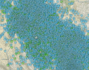
pointing finger hand shows the 6.3Mw
edit on 26-3-2013 by muzzy because: (no reason given)
new topics
-
SETI chief says US has no evidence for alien technology. 'And we never have'
Aliens and UFOs: 49 minutes ago -
This is our Story
General Entertainment: 3 hours ago -
President BIDEN Vows to Make Americans Pay More Federal Taxes in 2025 - Political Suicide.
2024 Elections: 5 hours ago -
Ode to Artemis
General Chit Chat: 6 hours ago -
Ditching physical money
History: 9 hours ago -
One Flame Throwing Robot Dog for Christmas Please!
Weaponry: 10 hours ago -
Don't take advantage of people just because it seems easy it will backfire
Rant: 10 hours ago -
VirginOfGrand says hello
Introductions: 11 hours ago -
Should Biden Replace Harris With AOC On the 2024 Democrat Ticket?
2024 Elections: 11 hours ago
top topics
-
University student disciplined after saying veganism is wrong and gender fluidity is stupid
Education and Media: 14 hours ago, 14 flags -
Police clash with St George’s Day protesters at central London rally
Social Issues and Civil Unrest: 17 hours ago, 10 flags -
President BIDEN Vows to Make Americans Pay More Federal Taxes in 2025 - Political Suicide.
2024 Elections: 5 hours ago, 10 flags -
Should Biden Replace Harris With AOC On the 2024 Democrat Ticket?
2024 Elections: 11 hours ago, 6 flags -
One Flame Throwing Robot Dog for Christmas Please!
Weaponry: 10 hours ago, 6 flags -
Ditching physical money
History: 9 hours ago, 4 flags -
Don't take advantage of people just because it seems easy it will backfire
Rant: 10 hours ago, 4 flags -
God lived as a Devil Dog.
Short Stories: 15 hours ago, 3 flags -
VirginOfGrand says hello
Introductions: 11 hours ago, 2 flags -
Geddy Lee in Conversation with Alex Lifeson - My Effin’ Life
People: 15 hours ago, 2 flags
active topics
-
SETI chief says US has no evidence for alien technology. 'And we never have'
Aliens and UFOs • 5 • : Consvoli -
"We're All Hamas" Heard at Columbia University Protests
Social Issues and Civil Unrest • 264 • : HopeForTheFuture -
University student disciplined after saying veganism is wrong and gender fluidity is stupid
Education and Media • 30 • : KrustyKrab -
Republican Voters Against Trump
2024 Elections • 288 • : burritocat -
Police clash with St George’s Day protesters at central London rally
Social Issues and Civil Unrest • 38 • : ohahhupthera -
Spectrophilia - Women Who Have Had Affairs With Ghosts Say Spooks Are Better Lovers Than Real Men
Paranormal Studies • 29 • : burritocat -
Should Biden Replace Harris With AOC On the 2024 Democrat Ticket?
2024 Elections • 45 • : burritocat -
Ditching physical money
History • 14 • : DerBeobachter2 -
British TV Presenter Refuses To Use Guest's Preferred Pronouns
Education and Media • 129 • : KrustyKrab -
-@TH3WH17ERABB17- -Q- ---TIME TO SHOW THE WORLD--- -Part- --44--
Dissecting Disinformation • 637 • : burritocat