It looks like you're using an Ad Blocker.
Please white-list or disable AboveTopSecret.com in your ad-blocking tool.
Thank you.
Some features of ATS will be disabled while you continue to use an ad-blocker.

Whats going on at yellowstone?
page: 700share:
Wow
700 pages
This has to be the biggest and most greatest resource about the Yellowstone caldera on the net
Hope that uplift chart was wrong
700 pages
This has to be the biggest and most greatest resource about the Yellowstone caldera on the net
Hope that uplift chart was wrong
reply to post by Nidwin
If you are meaning the big mass of wobbly jelly on the one below that is the Mag 6.8 in the Banda Sea going through on a broadband or a long period instrument such as the LISS recorders. This is also the red line on the short period instruments.
LKWY.US.00.BHZ.2011.242
Interestingly it is not actually on all of them. Mm.
Here it is on an LH channel LKWY.US.00.LHZ.2011.242
I do believe that the second part of the wobbles is it coming round again! I can't see anything else that would do that unless it is the ........... no not big enough.
reply to post by zenius
Nice to see you are still around. I have not seen you posting lately.
You had me going there - I thought we had got to page 1000 and I had not noticed!
If you are meaning the big mass of wobbly jelly on the one below that is the Mag 6.8 in the Banda Sea going through on a broadband or a long period instrument such as the LISS recorders. This is also the red line on the short period instruments.
LKWY.US.00.BHZ.2011.242
Interestingly it is not actually on all of them. Mm.
edit on 30/8/2011 by PuterMan because: (no reason given)
Here it is on an LH channel LKWY.US.00.LHZ.2011.242
I do believe that the second part of the wobbles is it coming round again! I can't see anything else that would do that unless it is the ........... no not big enough.
edit on 30/8/2011 by PuterMan because: (no reason given)
reply to post by zenius
Nice to see you are still around. I have not seen you posting lately.
You had me going there - I thought we had got to page 1000 and I had not noticed!
edit on 30/8/2011 by PuterMan because: (no reason given)
reply to post by PuterMan
Oh, you have changed it already. I'm still around, just got too busy to enjoy any ats leisure time for a while. Hope I haven't missed too much tectonic activity!
Oh, you have changed it already. I'm still around, just got too busy to enjoy any ats leisure time for a while. Hope I haven't missed too much tectonic activity!
Here is her monthly report for August.
Source - USGS - Yellowstone Recent Status Report
YELLOWSTONE VOLCANO OBSERVATORY MONTHLY UPDATE
Thursday, September 1, 2011 3:20 PM MDT (Thursday, September 1, 2011 21:20 UTC)
YELLOWSTONE VOLCANO (CAVW #1205-01-)
44°25'48" N 110°40'12" W, Summit Elevation 9203 ft (2805 m)
Current Volcano Alert Level: NORMAL
Current Aviation Color Code: GREEN
During the month of August 2011, 25 earthquakes were located in the Yellowstone National Park region. The largest was a magnitude 2.0 event on August 10 at 10:46 AM MDT, located about 18 miles northeast of Fishing Bridge, WY. No swarms were recorded in August.
Earthquake activity continues at relatively low background levels.
Ground Deformation Summary: A strong seasonal signal, probably related to last winter's extraordinary (~200% of normal) snowfall, is apparent on many of the GPS records in and well outside Yellowstone. This signal complicates interpretation of the GPS data, but detailed analysis indicates that caldera subsidence, which began about 1.5 years ago, likely persists. YVO scientists are working to understand the nature of the unusual signal, and will continue to monitor it carefully.
Source - USGS - Yellowstone Recent Status Report
Okay, anyone know exactly what this means...
"Ground Deformation Summary: A strong seasonal signal, probably related to last winter's extraordinary (~200% of normal) snowfall, is apparent on many of the GPS records in and well outside Yellowstone. This signal complicates interpretation of the GPS data, but detailed analysis indicates that caldera subsidence, which began about 1.5 years ago, likely persists. YVO scientists are working to understand the nature of the unusual signal, and will continue to monitor it carefully."
I did a quick search and figure it's "crustal displacement due to water loading".
If I'm off base please correct me.
reply to post by Robin Marks
GPS records in and well outside Yellowstone. This signal complicates interpretation of the GPS data,
GPS global position,,
depth ??? i always assumed surface depth.
depends how far the GPS DATA SIGNAL
penetrates.
i always assumed. surface.
singal = location markers moved.
crustal?
mantle?
mountain ranges?
the hole at yellowstone?
not enough info on the DATA
reply to post by Robin Marks
Hi Robin, yes ice on the GPS antenna gives false readings - a seasonal signal. This happens on Grimsvotn in Iceland as well. Probably in other but that is the only one I know about.
On Grims it makes it look as if there is inflation when there is not.
A strong seasonal signal, probably related to last winter's extraordinary (~200% of normal) snowfall, is apparent on many of the GPS records in and well outside Yellowstone.
Hi Robin, yes ice on the GPS antenna gives false readings - a seasonal signal. This happens on Grimsvotn in Iceland as well. Probably in other but that is the only one I know about.
On Grims it makes it look as if there is inflation when there is not.
edit on 20/9/2011 by PuterMan because: (no reason given)
reply to post by Lil Drummerboy
Not that quiet. There have been several quakes, but marked as Western Montana and not Yellowstone.
The lates I could find was at Hebgen Lake:
M 1.5, western Montana
Date: Monday, September 26, 2011 05:53:54 UTC
Sunday, September 25, 2011 11:53:54 PM at epicenter
Depth: 6.30 km (3.91 mi)
The lates I could find was at Hebgen Lake:
M 1.5, western Montana
Date: Monday, September 26, 2011 05:53:54 UTC
Sunday, September 25, 2011 11:53:54 PM at epicenter
Depth: 6.30 km (3.91 mi)
looks like 700 pages was enough for yellowstone.... the grant lady went into an deep sleep?? :-)
And without further ado from our sleepy Momma? the latest anticipated update :-)
Source
I appears to me that I am not the only one perplexed by the Ground Uplift- Folks - Jake - I am sorry, while yes, the record snowfall/water levels of last year "could have" moved the instruments - - - by summers end, they would have dropped back to subsidence levels - This has NOT happened - try again :-)
YELLOWSTONE VOLCANO OBSERVATORY MONTHLY UPDATE
Monday, October 3, 2011 10:54 AM MDT (Monday, October 3, 2011 16:54 UTC)
YELLOWSTONE VOLCANO (CAVW #1205-01-)
44°25'48" N 110°40'12" W, Summit Elevation 9203 ft (2805 m)
Current Volcano Alert Level: NORMAL
Current Aviation Color Code: GREEN
During the month of September 2011, 45 earthquakes were located in the Yellowstone National Park region. The largest was a magnitude 2.5 event on September 5 at 12:59 PM MDT, located about 8 miles west northwest of West Yellowstone, MT. No swarms were recorded in September.
Earthquake activity continues at relatively low background levels.
Ground Deformation Summary: A strong seasonal signal, probably related to last winter's extraordinary (~200% of normal) snowfall, is apparent on many of the GPS records in and well outside Yellowstone. This signal complicates interpretation of the GPS data, but detailed analysis indicates that caldera subsidence, which began about 1.5 years ago, likely persists. YVO scientists are working to understand the nature of the unusual signal, and will continue to monitor it carefully.
Please see: www.uusatrg.utah.edu... for a map of GPS stations in the Yellowstone vicinity. For a graph of daily GPS positions at White Lake, within the Yellowstone caldera, please see:
pboweb.unavco.org...×eries=raw
Source
I appears to me that I am not the only one perplexed by the Ground Uplift- Folks - Jake - I am sorry, while yes, the record snowfall/water levels of last year "could have" moved the instruments - - - by summers end, they would have dropped back to subsidence levels - This has NOT happened - try again :-)
edit on 3-10-2011 by Anmarie96 because: uplift you fool
edit on 3-10-2011 by Anmarie96 because: Once again this evening -
forgot the dreaded source - terms and condition ya know
reply to post by Anmarie96
Nor am I able to check on the temperature data recently. Such as Steamboat. volcanoes.usgs.gov...
I can find no data available at any of the monitoring stations. Curious
I will start checking more frequently.
Nor am I able to check on the temperature data recently. Such as Steamboat. volcanoes.usgs.gov...
I can find no data available at any of the monitoring stations. Curious
I will start checking more frequently.
Originally posted by Theriteway
reply to post by Anmarie96
Nor am I able to check on the temperature data recently. Such as Steamboat. volcanoes.usgs.gov...
I can find no data available at any of the monitoring stations. Curious
I will start checking more frequently.
Temps are partially back online . Nothing major to report. GrayLakes had an interesting bump up in temperature on the monthly graph. volcanoes.usgs.gov...
edit on 10/5/2011 by Theriteway because: (no reason given)
Forgive I havent followed this thread all the way here is a nice article relating to possible causes of super-volcano eruptions
source
nice read check it out
Researcher Patricia Gregg explains the process: "You can compare it to cracks forming on the top of baking bread as it expands. As the magma chamber pressurizes at depth, cracks form at the surface to accommodate the doming and expansion. Eventually, the cracks grow in size and propagate downward toward the magma chamber. In the case of very large volcanoes, when the cracks penetrate deep enough, they can rupture the magma chamber wall and trigger roof collapse and eruption."
source
nice read check it out
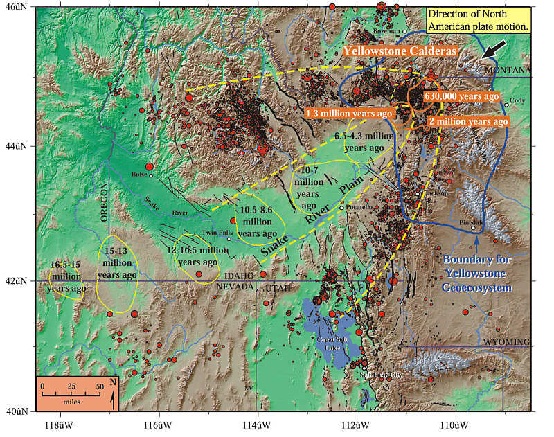
I have been searching for a map that shows the current position of the magma plume/chamber in relationship to the Yellowstone caldera. The crust is
moving over the hot spot and I am curious how far 'off center' (can't think of the term I want) it is. At some point in the future the crust will
move far enough and a new volcano/caldera will be created. Anyone ever hazard a guess when and where it will be?
Between the sensationalism and incorrect information on the net I haven't found this kind of information.
Thanks in advance for any useful information, and have a great day.
Between the sensationalism and incorrect information on the net I haven't found this kind of information.
Thanks in advance for any useful information, and have a great day.
reply to post by Anmarie96
Thank you for the map. But I've seen it before and other forms of it. I am looking for a map or something that shows the actual position of the magma plume and chamber in relationship to the Yellowstone caldera. I cannot find the one saw a months ago (it may have been on TV) but it shows the plume is no longer under Yellowstone magma chamber but shifted to the northeast which follows the map you posted.
I can find images of what the plume and magma chamber look like but nothing that has a map of Yellowstone on top of it. To show how far the chamber has drifted away from the plume.
new topics
-
WF Killer Patents & Secret Science Vol. 1 | Free Energy & Anti-Gravity Cover-Ups
General Conspiracies: 1 hours ago -
Hurt my hip; should I go see a Doctor
General Chit Chat: 2 hours ago -
Israel attacking Iran again.
Middle East Issues: 3 hours ago -
Michigan school district cancels lesson on gender identity and pronouns after backlash
Education and Media: 3 hours ago -
When an Angel gets his or her wings
Religion, Faith, And Theology: 4 hours ago -
Comparing the theology of Paul and Hebrews
Religion, Faith, And Theology: 5 hours ago -
Pentagon acknowledges secret UFO project, the Kona Blue program | Vargas Reports
Aliens and UFOs: 6 hours ago -
Boston Dynamics say Farewell to Atlas
Science & Technology: 6 hours ago -
I hate dreaming
Rant: 7 hours ago -
Man sets himself on fire outside Donald Trump trial
Mainstream News: 8 hours ago
top topics
-
The Democrats Take Control the House - Look what happened while you were sleeping
US Political Madness: 9 hours ago, 18 flags -
In an Historic First, In N Out Burger Permanently Closes a Location
Mainstream News: 11 hours ago, 16 flags -
A man of the people
Medical Issues & Conspiracies: 17 hours ago, 11 flags -
Biden says little kids flip him the bird all the time.
Politicians & People: 9 hours ago, 9 flags -
Man sets himself on fire outside Donald Trump trial
Mainstream News: 8 hours ago, 8 flags -
Michigan school district cancels lesson on gender identity and pronouns after backlash
Education and Media: 3 hours ago, 6 flags -
Pentagon acknowledges secret UFO project, the Kona Blue program | Vargas Reports
Aliens and UFOs: 6 hours ago, 6 flags -
Israel attacking Iran again.
Middle East Issues: 3 hours ago, 5 flags -
Boston Dynamics say Farewell to Atlas
Science & Technology: 6 hours ago, 4 flags -
WF Killer Patents & Secret Science Vol. 1 | Free Energy & Anti-Gravity Cover-Ups
General Conspiracies: 1 hours ago, 4 flags
active topics
-
Man sets himself on fire outside Donald Trump trial
Mainstream News • 39 • : TheMisguidedAngel -
When an Angel gets his or her wings
Religion, Faith, And Theology • 5 • : randomuser2034 -
Anyone one else having Youtube problems
Computer Help • 11 • : charlyv -
The Democrats Take Control the House - Look what happened while you were sleeping
US Political Madness • 68 • : Mahogani -
Candidate TRUMP Now Has Crazy Judge JUAN MERCHAN After Him - The Stormy Daniels Hush-Money Case.
Political Conspiracies • 404 • : Zanti Misfit -
In an Historic First, In N Out Burger Permanently Closes a Location
Mainstream News • 10 • : Degradation33 -
SC Jack Smith is Using Subterfuge Tricks with Donald Trumps Upcoming Documents Trial.
Dissecting Disinformation • 100 • : WeMustCare -
Israel attacking Iran again.
Middle East Issues • 23 • : KrustyKrab -
So I saw about 30 UFOs in formation last night.
Aliens and UFOs • 37 • : charlyv -
Hurt my hip; should I go see a Doctor
General Chit Chat • 11 • : TheLieWeLive