It looks like you're using an Ad Blocker.
Please white-list or disable AboveTopSecret.com in your ad-blocking tool.
Thank you.
Some features of ATS will be disabled while you continue to use an ad-blocker.

Whats going on at yellowstone?
page: 659share:
Originally posted by Antoniastar
Just found this on my Twitter...I've subscribed to EQTW tweets.
4.6 - YELLOWSTONE NATIONAL PARK, WYOMING: Date: Sat, 12 Feb 2011 02:36:09 UTCLat/Lon: 44.2703/-110.973Depth: 15.5
earthquake.usgs.gov...
Someone will want to repost it in full..most likely.
Toniedit on 11-2-2011 by Antoniastar because: to add more detail.
there is no quake of that size anywhere on the park
Could the rise be because earth is the only planet on this side of the galaxy.With all of the other planets together pulling from the other side of
the galaxy? These effects on 3/11 thur 3/12 2011 will reveal all of the worlds written religious beginnings in the sky. As the planets/stars and moon
are the gods,goddesses,saviors,hero's and villains of our religious past.For example on 3/12 at 22:33: any seconds with Stellarium everyone may see
the Egyptian/Christian religion rising in the east.In china,go to the direction that alines the planets as a serpent/dragon and with the right buttons
you can watch the moon ride along the serpents/dragons back and back to china's beginnings.Don't worry my jaw dropped too when i seen All of the
worlds ancient religious beginnings and their stories in this one day when seen from the four directions.Dim the sun/son to see them all.
Originally posted by alysha.angel
Originally posted by Antoniastar
Just found this on my Twitter...I've subscribed to EQTW tweets.
4.6 - YELLOWSTONE NATIONAL PARK, WYOMING: Date: Sat, 12 Feb 2011 02:36:09 UTCLat/Lon: 44.2703/-110.973Depth: 15.5
earthquake.usgs.gov...
Someone will want to repost it in full..most likely.
Toniedit on 11-2-2011 by Antoniastar because: to add more detail.
there is no quake of that size anywhere on the park
I don't see any earthquake, do you? There's no quake. I don't know what your're talking about. Quake? What quake?
It will be down-graded then?
edit on 11-2-2011 by Antoniastar because: tyooooooooooo
Looks like a lot of wind noise on a 1/3 of the sensors or so for the area.
I think it was likely a tree falling or something, more than likely you'll see a deletion notice pop up.
Either that or the UoU folks are messing with you.
M.
(Back to lurking )
I think it was likely a tree falling or something, more than likely you'll see a deletion notice pop up.
Either that or the UoU folks are messing with you.
M.
(Back to lurking )
Oh yeah! And here is a visual of the event.
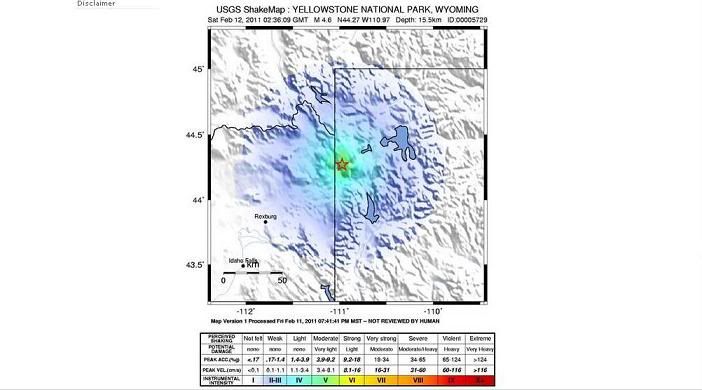
earthquake.usgs.gov...
You know I sure wish they wouldn't report this as a 4.6 if it's not true. Maybe a seismo in the middle of the park is malfunctioning?
earthquake.usgs.gov...
You know I sure wish they wouldn't report this as a 4.6 if it's not true. Maybe a seismo in the middle of the park is malfunctioning?
reply to post by Antoniastar
Wel, it WAS there and then removed. This has been going on for awhile now. Puterman was able to get confirmation that this is due to a software problem.
This is the most recent one...will see if it sticks:
Magnitude 2.3
Date-Time Saturday, February 12, 2011 at 04:55:13 UTC
Friday, February 11, 2011 at 09:55:13 PM at epicenter
Location 44.606°N, 110.783°W
Depth 19 km (11.8 miles)
Region YELLOWSTONE NATIONAL PARK, WYOMING
Distances 26 km (16 miles) ESE (104°) from West Yellowstone, MT
46 km (28 miles) ENE (75°) from Island Park, ID
48 km (30 miles) S (187°) from Gardiner, MT
438 km (272 miles) NNE (12°) from Salt Lake City, UT
Location Uncertainty horizontal +/- 0.9 km (0.6 miles); depth +/- 2.2 km (1.4 miles)
Parameters NST= 9, Nph= 9, Dmin=25 km, Rmss=0.23 sec, Gp= 94°,
M-type=duration magnitude (Md), Version=0
Source University of Utah Seismograph Stations
Event ID uu00005776
EDIT TO ADD: Just like that.....it is gone. They really need to get this figured out. I simply can't believe that something this important can be so poorly neglected.
edit on 11-2-2011 by westcoast because: (no reason given)
Originally posted by Moshpet
Looks like a lot of wind noise on a 1/3 of the sensors or so for the area.
I think it was likely a tree falling or something, more than likely you'll see a deletion notice pop up.
Either that or the UoU folks are messing with you.
M.
(Back to lurking )
OMG! Wind? A felled tree? Oh I didn't think of that. Well hm. Though I did think of the deletion thingy. That's why I screen-captured the event. Ahhhhh Ha!
Let's just hope it's either something like a sensor problem or someone is just posting prank read-outs to mess with us because a 4.6 at the park right now, as in the form of a quake, is not good. I'm no expert on Y.P. but I did grow up with earthquakes in Southern Cali. I'm good at the other end of the quake thing.
Cross your fingers.
reply to post by westcoast
Oh! Now that makes sense. A software problem. I agree, this is no time to be neglectful or whatever is going on over there at the earthquake department.
Thanks for the latest quake update.
We need to watch out for each other.
Luv this thread btw, Puterman. You guys are doing an excellent job!
Take care,
Toni
edit on 11-2-2011 by Antoniastar because: (no reason given)
A 4.0+ will ring pretty much every sensor in the park.
If you look at the location given, it's near the Old Faithful area, cross checking the sensors around YFT would show a -huge- jolt but none do.
YFT if I remember correctly is the most sensitive of the parks sensors, it picks up every bit of carp .
www.seis.utah.edu...
The odd waves at around 20:45 UTC are from a distant quake that was echoing around the layers of the planet. I doubt the latest quake reported will last the night, as it too is not reported but from one sensor.
Seriously?? The deletion of the 4.6 is because of "software issues"????
Why am I having such a hard time believing this?!
Why am I having such a hard time believing this?!
[atsimg]http://files.abovetopsecret.com/images/member/3a1661b653f9.jpg[/atsimg]
Are these 'real' earthquakes on the USGS website or more false positives?
earthquake.usgs.gov...
I usually go to isthisthingon.org to look at the siesmographs but cant access them to verify.
Ok, now they have been removed.A 3.4 and 3 2point somethings. Sorry didnt take a screen shot.
earthquake.usgs.gov...
I usually go to isthisthingon.org to look at the siesmographs but cant access them to verify.
edit on 12/2/11 by logicalview because:
Additional comment
Ok, now they have been removed.A 3.4 and 3 2point somethings. Sorry didnt take a screen shot.
edit on 12/2/11 by logicalview because:
additional comment
[atsimg]http://files.abovetopsecret.com/images/member/ce04278f11f9.jpg[/atsimg]
1.9 2011/02/12 10:30:53 44.384 -110.464 1.0 60 km ( 37 mi) ESE of West Yellowstone, MT
1.7 2011/02/12 10:25:45 44.584 -110.648 8.2 37 km ( 23 mi) ESE of West Yellowstone, MT
2.0 2011/02/12 09:43:56 44.541 -110.832 16.2 26 km ( 16 mi) ESE of West Yellowstone, MT
1.9 2011/02/12 10:30:53 44.384 -110.464 1.0 60 km ( 37 mi) ESE of West Yellowstone, MT
1.7 2011/02/12 10:25:45 44.584 -110.648 8.2 37 km ( 23 mi) ESE of West Yellowstone, MT
2.0 2011/02/12 09:43:56 44.541 -110.832 16.2 26 km ( 16 mi) ESE of West Yellowstone, MT
[atsimg]http://files.abovetopsecret.com/images/member/b6d34970362d.jpg[/atsimg]
1.9 2011/02/12 10:30:53 44.384 -110.464 1.0 60 km ( 37 mi) ESE of West Yellowstone, MT
1.7 2011/02/12 10:25:45 44.584 -110.648 8.2 37 km ( 23 mi) ESE of West Yellowstone, MT
2.0 2011/02/12 09:43:56 44.541 -110.832 16.2 26 km ( 16 mi) ESE of West Yellowstone, MT
2.0 2011/02/12 09:37:52 44.592 -110.964 23.6 14 km ( 9 mi) SE of West Yellowstone, MT
[atsimg]http://files.abovetopsecret.com/images/member/1be1f418fa13.jpg[/atsimg]
1.5 2011/02/12 10:44:00 44.590 -110.740 21.7 30 km ( 19 mi) ESE of West Yellowstone, MT
1.7 2011/02/12 10:42:30 44.800 -110.972 23.4 19 km ( 12 mi) NE of West Yellowstone, MT
1.9 2011/02/12 10:30:53 44.384 -110.464 1.0 60 km ( 37 mi) ESE of West Yellowstone, MT
1.7 2011/02/12 10:25:45 44.584 -110.648 8.2 37 km ( 23 mi) ESE of West Yellowstone, MT
2.0 2011/02/12 09:43:56 44.541 -110.832 16.2 26 km ( 16 mi) ESE of West Yellowstone, MT
2.0 2011/02/12 09:37:52 44.592 -110.964 23.6 14 km ( 9 mi) SE of West Yellowstone, MT
[atsimg]http://files.abovetopsecret.com/images/member/1be1f418fa13.jpg[/atsimg]
1.5 2011/02/12 10:44:00 44.590 -110.740 21.7 30 km ( 19 mi) ESE of West Yellowstone, MT
1.7 2011/02/12 10:42:30 44.800 -110.972 23.4 19 km ( 12 mi) NE of West Yellowstone, MT
1.9 2011/02/12 10:30:53 44.384 -110.464 1.0 60 km ( 37 mi) ESE of West Yellowstone, MT
1.7 2011/02/12 10:25:45 44.584 -110.648 8.2 37 km ( 23 mi) ESE of West Yellowstone, MT
2.0 2011/02/12 09:43:56 44.541 -110.832 16.2 26 km ( 16 mi) ESE of West Yellowstone, MT
2.0 2011/02/12 09:37:52 44.592 -110.964 23.6 14 km ( 9 mi) SE of West Yellowstone, MT
edit on 12-2-2011 by berkeleygal because: (no reason
given)
reply to post by berkeleygal
Ha, I was just about to post the same thing before heading to bed.
I guess this would go along with Robins thoughts as to stirring the pot. It is friday after all.
I mean, get the program fixed already. I am not feeling too good about the monitoring going on in the park right now!
Ha, I was just about to post the same thing before heading to bed.
I guess this would go along with Robins thoughts as to stirring the pot. It is friday after all.
I mean, get the program fixed already. I am not feeling too good about the monitoring going on in the park right now!
2.4 2011/02/12 11:00:02 44.706 -111.132 1.0 5 km ( 3 mi) NNW of West Yellowstone, MT
one more to add
thats 7 in an hour and a half
another
1.9 2011/02/12 11:14:12 44.393 -110.545 0.7 54 km ( 33 mi) SE of West Yellowstone, MT
one more to add
thats 7 in an hour and a half
another
1.9 2011/02/12 11:14:12 44.393 -110.545 0.7 54 km ( 33 mi) SE of West Yellowstone, MT
edit on 12-2-2011 by berkeleygal because: (no reason given)
edit on 12-2-2011 by berkeleygal because: (no reason
given)
== PRELIMINARY EARTHQUAKE REPORT ==
Region: YELLOWSTONE NAT. PARK, WYOMING
Geographic coordinates: 44.594N, 110.674W
Magnitude: 2.1 Md
Depth: 16 km
Universal Time (UTC): 12 Feb 2011 03:25:24
Time near the Epicenter: 11 Feb 2011 20:25:24
Local standard time in your area: 12 Feb 2011 04:25:24
Location with respect to nearby cities:
35 km (22 miles) ESE (102 degrees) of West Yellowstone, MT
49 km (31 miles) S (176 degrees) of Gardiner, MT
54 km (33 miles) E (79 degrees) of Island Park, ID
438 km (272 miles) NNE (13 degrees) of Salt Lake City, UT
ADDITIONAL EARTHQUAKE PARAMETERS
________________________________
event ID : UU 00005741
DELETED: Event UU 00005741
== EVENT DELETED NOTIFICATION ==
***This event has been deleted after review by a seismologist.***
Geographic coordinates: 44.594N, 110.674W
Magnitude: 2.1
Universal Time (UTC): 12 Feb 2011 03:25:24
Time near the Epicenter: 11 Feb 2011 20:25:24
Location with respect to nearby cities:
35 km (22 miles) ESE (102 degrees) of West Yellowstone, MT
49 km (31 miles) S (176 degrees) of Gardiner, MT
54 km (33 miles) E (79 degrees) of Island Park, ID
438 km (272 miles) NNE (13 degrees) of Salt Lake City, UT
== PRELIMINARY EARTHQUAKE REPORT ==
Region: YELLOWSTONE NAT. PARK, WYOMING
Geographic coordinates: 44.315N, 110.593W
Magnitude: 2.0 Md
Depth: 24 km
Universal Time (UTC): 12 Feb 2011 04:11:24
Time near the Epicenter: 11 Feb 2011 21:11:24
Local standard time in your area: 12 Feb 2011 05:11:24
Location with respect to nearby cities:
56 km (35 miles) SE (133 degrees) of West Yellowstone, MT
62 km (38 miles) ENE (69 degrees) of Warm River, ID
63 km (39 miles) ESE (109 degrees) of Island Park, ID
410 km (255 miles) NNE (15 degrees) of Salt Lake City, UT
ADDITIONAL EARTHQUAKE PARAMETERS
________________________________
event ID : UU 00005759
DELETED: Event UU 00005759
== EVENT DELETED NOTIFICATION ==
***This event has been deleted after review by a seismologist.***
Geographic coordinates: 44.315N, 110.593W
Magnitude: 2.0
Universal Time (UTC): 12 Feb 2011 04:11:24
Time near the Epicenter: 11 Feb 2011 21:11:24
Location with respect to nearby cities:
56 km (35 miles) SE (133 degrees) of West Yellowstone, MT
62 km (38 miles) ENE (69 degrees) of Warm River, ID
63 km (39 miles) ESE (109 degrees) of Island Park, ID
410 km (255 miles) NNE (15 degrees) of Salt Lake City, UT
== PRELIMINARY EARTHQUAKE REPORT ==
Region: YELLOWSTONE NAT. PARK, WYOMING
Geographic coordinates: 44.679N, 110.690W
Magnitude: 1.6 Md
Depth: 13 km
Universal Time (UTC): 12 Feb 2011 04:22:30
Time near the Epicenter: 11 Feb 2011 21:22:30
Local standard time in your area: 12 Feb 2011 05:22:30
Location with respect to nearby cities:
33 km (20 miles) E (87 degrees) of West Yellowstone, MT
40 km (25 miles) S (177 degrees) of Gardiner, MT
55 km (34 miles) ENE (69 degrees) of Island Park, ID
447 km (278 miles) NNE (12 degrees) of Salt Lake City, UT
ADDITIONAL EARTHQUAKE PARAMETERS
________________________________
event ID : UU 00005763
DELETED: Event UU 00005763
== EVENT DELETED NOTIFICATION ==
***This event has been deleted after review by a seismologist.***
Geographic coordinates: 44.679N, 110.690W
Magnitude: 1.6
Universal Time (UTC): 12 Feb 2011 04:22:30
Time near the Epicenter: 11 Feb 2011 21:22:30
Location with respect to nearby cities:
33 km (20 miles) E (87 degrees) of West Yellowstone, MT
40 km (25 miles) S (177 degrees) of Gardiner, MT
55 km (34 miles) ENE (69 degrees) of Island Park, ID
447 km (278 miles) NNE (12 degrees) of Salt Lake City, UT
== PRELIMINARY EARTHQUAKE REPORT ==
Region: YELLOWSTONE NAT. PARK, WYOMING
Geographic coordinates: 44.606N, 110.783W
Magnitude: 2.3 Md
Depth: 19 km
Universal Time (UTC): 12 Feb 2011 04:55:13
Time near the Epicenter: 11 Feb 2011 21:55:13
Local standard time in your area: 12 Feb 2011 05:55:13
Location with respect to nearby cities:
26 km (16 miles) ESE (104 degrees) of West Yellowstone, MT
46 km (28 miles) ENE (75 degrees) of Island Park, ID
48 km (30 miles) S (187 degrees) of Gardiner, MT
438 km (272 miles) NNE (12 degrees) of Salt Lake City, UT
ADDITIONAL EARTHQUAKE PARAMETERS
________________________________
event ID : UU 00005776
DELETED: Event UU 00005776
== EVENT DELETED NOTIFICATION ==
***This event has been deleted after review by a seismologist.***
Geographic coordinates: 44.606N, 110.783W
Magnitude: 2.3
Universal Time (UTC): 12 Feb 2011 04:55:13
Time near the Epicenter: 11 Feb 2011 21:55:13
Location with respect to nearby cities:
26 km (16 miles) ESE (104 degrees) of West Yellowstone, MT
46 km (28 miles) ENE (75 degrees) of Island Park, ID
48 km (30 miles) S (187 degrees) of Gardiner, MT
438 km (272 miles) NNE (12 degrees) of Salt Lake City, UT
== PRELIMINARY EARTHQUAKE REPORT ==
Region: YELLOWSTONE NAT. PARK, WYOMING
Geographic coordinates: 44.722N, 110.660W
Magnitude: 2.8 Md
Depth: 0 km
Universal Time (UTC): 12 Feb 2011 05:02:32
Time near the Epicenter: 11 Feb 2011 22:02:32
Local standard time in your area: 12 Feb 2011 06:02:32
Location with respect to nearby cities:
35 km (22 miles) S (173 degrees) of Gardiner, MT
36 km (22 miles) E (79 degrees) of West Yellowstone, MT
59 km (37 miles) ENE (65 degrees) of Island Park, ID
452 km (281 miles) NNE (12 degrees) of Salt Lake City, UT
ADDITIONAL EARTHQUAKE PARAMETERS
________________________________
event ID : UU 00005778
DELETED: Event UU 00005778
== EVENT DELETED NOTIFICATION ==
***This event has been deleted after review by a seismologist.***
Geographic coordinates: 44.722N, 110.660W
Magnitude: 2.8
Universal Time (UTC): 12 Feb 2011 05:02:32
Time near the Epicenter: 11 Feb 2011 22:02:32
Location with respect to nearby cities:
35 km (22 miles) S (173 degrees) of Gardiner, MT
36 km (22 miles) E (79 degrees) of West Yellowstone, MT
59 km (37 miles) ENE (65 degrees) of Island Park, ID
452 km (281 miles) NNE (12 degrees) of Salt Lake City, UT
== PRELIMINARY EARTHQUAKE REPORT ==
Region: YELLOWSTONE NAT. PARK, WYOMING
Geographic coordinates: 44.512N, 110.831W
Magnitude: 2.6 Md
Depth: 19 km
Universal Time (UTC): 12 Feb 2011 05:20:06
Time near the Epicenter: 11 Feb 2011 22:20:06
Local standard time in your area: 12 Feb 2011 06:20:06
Location with respect to nearby cities:
27 km (17 miles) SE (127 degrees) of West Yellowstone, MT
40 km (25 miles) E (88 degrees) of Island Park, ID
59 km (36 miles) NE (41 degrees) of Warm River, ID
427 km (265 miles) N (11 degrees) of Salt Lake City, UT
ADDITIONAL EARTHQUAKE PARAMETERS
________________________________
event ID : UU 00005785
DELETED: Event UU 00005785
== EVENT DELETED NOTIFICATION ==
***This event has been deleted after review by a seismologist.***
Geographic coordinates: 44.512N, 110.831W
Magnitude: 2.6
Universal Time (UTC): 12 Feb 2011 05:20:06
Time near the Epicenter: 11 Feb 2011 22:20:06
Location with respect to nearby cities:
27 km (17 miles) SE (127 degrees) of West Yellowstone, MT
40 km (25 miles) E (88 degrees) of Island Park, ID
59 km (36 miles) NE (41 degrees) of Warm River, ID
427 km (265 miles) N (11 degrees) of Salt Lake City, UT
== PRELIMINARY EARTHQUAKE REPORT ==
Region: YELLOWSTONE NAT. PARK, WYOMING
Geographic coordinates: 44.613N, 110.875W
Magnitude: 2.1 Md
Depth: 4 km
Universal Time (UTC): 12 Feb 2011 05:25:00
Time near the Epicenter: 11 Feb 2011 22:25:00
Local standard time in your area: 12 Feb 2011 06:25:00
Location with respect to nearby cities:
19 km (12 miles) ESE (107 degrees) of West Yellowstone, MT
39 km (24 miles) ENE (71 degrees) of Island Park, ID
49 km (30 miles) SSW (195 degrees) of Gardiner, MT
437 km (272 miles) N (11 degrees) of Salt Lake City, UT
ADDITIONAL EARTHQUAKE PARAMETERS
________________________________
event ID : UU 00005786
== PRELIMINARY EARTHQUAKE REPORT ==
Region: YELLOWSTONE NAT. PARK, WYOMING
Geographic coordinates: 44.459N, 110.817W
Magnitude: 2.6 Md
Depth: 3 km
Universal Time (UTC): 12 Feb 2011 05:39:42
Time near the Epicenter: 11 Feb 2011 22:39:42
Local standard time in your area: 12 Feb 2011 06:39:42
Location with respect to nearby cities:
32 km (20 miles) SE (135 degrees) of West Yellowstone, MT
42 km (26 miles) E (96 degrees) of Island Park, ID
55 km (34 miles) NE (46 degrees) of Warm River, ID
421 km (262 miles) NNE (12 degrees) of Salt Lake City, UT
ADDITIONAL EARTHQUAKE PARAMETERS
________________________________
event ID : UU 00005792

Region: YELLOWSTONE NAT. PARK, WYOMING
Geographic coordinates: 44.594N, 110.674W
Magnitude: 2.1 Md
Depth: 16 km
Universal Time (UTC): 12 Feb 2011 03:25:24
Time near the Epicenter: 11 Feb 2011 20:25:24
Local standard time in your area: 12 Feb 2011 04:25:24
Location with respect to nearby cities:
35 km (22 miles) ESE (102 degrees) of West Yellowstone, MT
49 km (31 miles) S (176 degrees) of Gardiner, MT
54 km (33 miles) E (79 degrees) of Island Park, ID
438 km (272 miles) NNE (13 degrees) of Salt Lake City, UT
ADDITIONAL EARTHQUAKE PARAMETERS
________________________________
event ID : UU 00005741
DELETED: Event UU 00005741
== EVENT DELETED NOTIFICATION ==
***This event has been deleted after review by a seismologist.***
Geographic coordinates: 44.594N, 110.674W
Magnitude: 2.1
Universal Time (UTC): 12 Feb 2011 03:25:24
Time near the Epicenter: 11 Feb 2011 20:25:24
Location with respect to nearby cities:
35 km (22 miles) ESE (102 degrees) of West Yellowstone, MT
49 km (31 miles) S (176 degrees) of Gardiner, MT
54 km (33 miles) E (79 degrees) of Island Park, ID
438 km (272 miles) NNE (13 degrees) of Salt Lake City, UT
== PRELIMINARY EARTHQUAKE REPORT ==
Region: YELLOWSTONE NAT. PARK, WYOMING
Geographic coordinates: 44.315N, 110.593W
Magnitude: 2.0 Md
Depth: 24 km
Universal Time (UTC): 12 Feb 2011 04:11:24
Time near the Epicenter: 11 Feb 2011 21:11:24
Local standard time in your area: 12 Feb 2011 05:11:24
Location with respect to nearby cities:
56 km (35 miles) SE (133 degrees) of West Yellowstone, MT
62 km (38 miles) ENE (69 degrees) of Warm River, ID
63 km (39 miles) ESE (109 degrees) of Island Park, ID
410 km (255 miles) NNE (15 degrees) of Salt Lake City, UT
ADDITIONAL EARTHQUAKE PARAMETERS
________________________________
event ID : UU 00005759
DELETED: Event UU 00005759
== EVENT DELETED NOTIFICATION ==
***This event has been deleted after review by a seismologist.***
Geographic coordinates: 44.315N, 110.593W
Magnitude: 2.0
Universal Time (UTC): 12 Feb 2011 04:11:24
Time near the Epicenter: 11 Feb 2011 21:11:24
Location with respect to nearby cities:
56 km (35 miles) SE (133 degrees) of West Yellowstone, MT
62 km (38 miles) ENE (69 degrees) of Warm River, ID
63 km (39 miles) ESE (109 degrees) of Island Park, ID
410 km (255 miles) NNE (15 degrees) of Salt Lake City, UT
== PRELIMINARY EARTHQUAKE REPORT ==
Region: YELLOWSTONE NAT. PARK, WYOMING
Geographic coordinates: 44.679N, 110.690W
Magnitude: 1.6 Md
Depth: 13 km
Universal Time (UTC): 12 Feb 2011 04:22:30
Time near the Epicenter: 11 Feb 2011 21:22:30
Local standard time in your area: 12 Feb 2011 05:22:30
Location with respect to nearby cities:
33 km (20 miles) E (87 degrees) of West Yellowstone, MT
40 km (25 miles) S (177 degrees) of Gardiner, MT
55 km (34 miles) ENE (69 degrees) of Island Park, ID
447 km (278 miles) NNE (12 degrees) of Salt Lake City, UT
ADDITIONAL EARTHQUAKE PARAMETERS
________________________________
event ID : UU 00005763
DELETED: Event UU 00005763
== EVENT DELETED NOTIFICATION ==
***This event has been deleted after review by a seismologist.***
Geographic coordinates: 44.679N, 110.690W
Magnitude: 1.6
Universal Time (UTC): 12 Feb 2011 04:22:30
Time near the Epicenter: 11 Feb 2011 21:22:30
Location with respect to nearby cities:
33 km (20 miles) E (87 degrees) of West Yellowstone, MT
40 km (25 miles) S (177 degrees) of Gardiner, MT
55 km (34 miles) ENE (69 degrees) of Island Park, ID
447 km (278 miles) NNE (12 degrees) of Salt Lake City, UT
== PRELIMINARY EARTHQUAKE REPORT ==
Region: YELLOWSTONE NAT. PARK, WYOMING
Geographic coordinates: 44.606N, 110.783W
Magnitude: 2.3 Md
Depth: 19 km
Universal Time (UTC): 12 Feb 2011 04:55:13
Time near the Epicenter: 11 Feb 2011 21:55:13
Local standard time in your area: 12 Feb 2011 05:55:13
Location with respect to nearby cities:
26 km (16 miles) ESE (104 degrees) of West Yellowstone, MT
46 km (28 miles) ENE (75 degrees) of Island Park, ID
48 km (30 miles) S (187 degrees) of Gardiner, MT
438 km (272 miles) NNE (12 degrees) of Salt Lake City, UT
ADDITIONAL EARTHQUAKE PARAMETERS
________________________________
event ID : UU 00005776
DELETED: Event UU 00005776
== EVENT DELETED NOTIFICATION ==
***This event has been deleted after review by a seismologist.***
Geographic coordinates: 44.606N, 110.783W
Magnitude: 2.3
Universal Time (UTC): 12 Feb 2011 04:55:13
Time near the Epicenter: 11 Feb 2011 21:55:13
Location with respect to nearby cities:
26 km (16 miles) ESE (104 degrees) of West Yellowstone, MT
46 km (28 miles) ENE (75 degrees) of Island Park, ID
48 km (30 miles) S (187 degrees) of Gardiner, MT
438 km (272 miles) NNE (12 degrees) of Salt Lake City, UT
== PRELIMINARY EARTHQUAKE REPORT ==
Region: YELLOWSTONE NAT. PARK, WYOMING
Geographic coordinates: 44.722N, 110.660W
Magnitude: 2.8 Md
Depth: 0 km
Universal Time (UTC): 12 Feb 2011 05:02:32
Time near the Epicenter: 11 Feb 2011 22:02:32
Local standard time in your area: 12 Feb 2011 06:02:32
Location with respect to nearby cities:
35 km (22 miles) S (173 degrees) of Gardiner, MT
36 km (22 miles) E (79 degrees) of West Yellowstone, MT
59 km (37 miles) ENE (65 degrees) of Island Park, ID
452 km (281 miles) NNE (12 degrees) of Salt Lake City, UT
ADDITIONAL EARTHQUAKE PARAMETERS
________________________________
event ID : UU 00005778
DELETED: Event UU 00005778
== EVENT DELETED NOTIFICATION ==
***This event has been deleted after review by a seismologist.***
Geographic coordinates: 44.722N, 110.660W
Magnitude: 2.8
Universal Time (UTC): 12 Feb 2011 05:02:32
Time near the Epicenter: 11 Feb 2011 22:02:32
Location with respect to nearby cities:
35 km (22 miles) S (173 degrees) of Gardiner, MT
36 km (22 miles) E (79 degrees) of West Yellowstone, MT
59 km (37 miles) ENE (65 degrees) of Island Park, ID
452 km (281 miles) NNE (12 degrees) of Salt Lake City, UT
== PRELIMINARY EARTHQUAKE REPORT ==
Region: YELLOWSTONE NAT. PARK, WYOMING
Geographic coordinates: 44.512N, 110.831W
Magnitude: 2.6 Md
Depth: 19 km
Universal Time (UTC): 12 Feb 2011 05:20:06
Time near the Epicenter: 11 Feb 2011 22:20:06
Local standard time in your area: 12 Feb 2011 06:20:06
Location with respect to nearby cities:
27 km (17 miles) SE (127 degrees) of West Yellowstone, MT
40 km (25 miles) E (88 degrees) of Island Park, ID
59 km (36 miles) NE (41 degrees) of Warm River, ID
427 km (265 miles) N (11 degrees) of Salt Lake City, UT
ADDITIONAL EARTHQUAKE PARAMETERS
________________________________
event ID : UU 00005785
DELETED: Event UU 00005785
== EVENT DELETED NOTIFICATION ==
***This event has been deleted after review by a seismologist.***
Geographic coordinates: 44.512N, 110.831W
Magnitude: 2.6
Universal Time (UTC): 12 Feb 2011 05:20:06
Time near the Epicenter: 11 Feb 2011 22:20:06
Location with respect to nearby cities:
27 km (17 miles) SE (127 degrees) of West Yellowstone, MT
40 km (25 miles) E (88 degrees) of Island Park, ID
59 km (36 miles) NE (41 degrees) of Warm River, ID
427 km (265 miles) N (11 degrees) of Salt Lake City, UT
== PRELIMINARY EARTHQUAKE REPORT ==
Region: YELLOWSTONE NAT. PARK, WYOMING
Geographic coordinates: 44.613N, 110.875W
Magnitude: 2.1 Md
Depth: 4 km
Universal Time (UTC): 12 Feb 2011 05:25:00
Time near the Epicenter: 11 Feb 2011 22:25:00
Local standard time in your area: 12 Feb 2011 06:25:00
Location with respect to nearby cities:
19 km (12 miles) ESE (107 degrees) of West Yellowstone, MT
39 km (24 miles) ENE (71 degrees) of Island Park, ID
49 km (30 miles) SSW (195 degrees) of Gardiner, MT
437 km (272 miles) N (11 degrees) of Salt Lake City, UT
ADDITIONAL EARTHQUAKE PARAMETERS
________________________________
event ID : UU 00005786
== PRELIMINARY EARTHQUAKE REPORT ==
Region: YELLOWSTONE NAT. PARK, WYOMING
Geographic coordinates: 44.459N, 110.817W
Magnitude: 2.6 Md
Depth: 3 km
Universal Time (UTC): 12 Feb 2011 05:39:42
Time near the Epicenter: 11 Feb 2011 22:39:42
Local standard time in your area: 12 Feb 2011 06:39:42
Location with respect to nearby cities:
32 km (20 miles) SE (135 degrees) of West Yellowstone, MT
42 km (26 miles) E (96 degrees) of Island Park, ID
55 km (34 miles) NE (46 degrees) of Warm River, ID
421 km (262 miles) NNE (12 degrees) of Salt Lake City, UT
ADDITIONAL EARTHQUAKE PARAMETERS
________________________________
event ID : UU 00005792
Originally posted by westcoast
Let's see how long it takes for these be erased:
2.0 2011/02/12 02:43:56 44.541N 110.832W 16.2 26 km (16 mi) ESE of West Yellowstone, MT
2.0 2011/02/12 02:37:52 44.592N 110.964W 23.6 14 km ( 8 mi) SE of West Yellowstone, MT
source
Looking at berkeleygal's listing which is in UTC against your MST, the 02:43:56 is 09:43:56
It is also listed as such in my listing that comes from the 7 day file.
There is a quake showing on the siesmos of about the right size but ti is 2 hours earlier.
B208.PB..EHZ.2011.043
Can't see anything in the list that matches this. It does show (just) on other recorders.
MAG DATE LOCAL-TIME LAT LON DEPTH LOCATION
y/m/d h:m:s deg deg km
1.7 2011/02/12 04:34:23 44.692N 110.561W 1.2 40 km (25 mi) SSE of Gardiner, MT
1.6 2011/02/12 04:27:15 44.701N 110.659W 13.8 36 km (22 mi) E of West Yellowstone, MT
1.9 2011/02/12 04:14:12 44.393N 110.545W 0.7 54 km (33 mi) SE of West Yellowstone, MT
2.4 2011/02/12 04:00:02 44.706N 111.132W 1.0 5 km ( 3 mi) NNW of West Yellowstone, MT
1.5 2011/02/12 03:44:00 44.590N 110.740W 21.7 30 km (19 mi) ESE of West Yellowstone, MT
1.7 2011/02/12 03:42:30 44.800N 110.972W 23.4 19 km (12 mi) NE of West Yellowstone, MT
1.9 2011/02/12 03:30:53 44.384N 110.464W 1.0 60 km (37 mi) ESE of West Yellowstone, MT
1.7 2011/02/12 03:25:45 44.584N 110.648W 8.2 37 km (23 mi) ESE of West Yellowstone, MT
2.0 2011/02/12 02:43:56 44.541N 110.832W 16.2 26 km (16 mi) ESE of West Yellowstone, MT
2.0 2011/02/12 02:37:52 44.592N 110.964W 23.6 14 km ( 8 mi) SE of West Yellowstone, MT
0.7 2011/02/09 20:55:32 44.753N 110.925W 9.6 18 km (11 mi) NE of West Yellowstone, MT
1.5 2011/02/09 17:07:11 45.021N 111.075W 8.6 28 km (18 mi) W of Gardiner, MT
0.3 2011/02/09 14:43:08 44.547N 111.010W 13.0 15 km ( 9 mi) SSE of West Yellowstone, MT
1.1 2011/02/09 14:16:42 44.539N 111.017W 13.1 15 km (10 mi) SSE of West Yellowstone, MT
1.5 2011/02/09 13:24:05 44.547N 111.020W 12.9 14 km ( 9 mi) SSE of West Yellowstone, MT
0.7 2011/02/09 13:19:14 44.550N 111.014W 13.5 14 km ( 9 mi) SSE of West Yellowstone, MT
0.9 2011/02/09 13:15:40 44.544N 111.014W 12.4 15 km ( 9 mi) SSE of West Yellowstone, MT
0.9 2011/02/09 13:15:40 44.544N 111.014W 12.4 15 km ( 9 mi) SSE of West Yellowstone, MT
0.7 2011/02/09 13:15:09 44.549N 111.014W 12.6 15 km ( 9 mi) SSE of West Yellowstone, MT
0.7 2011/02/09 12:40:01 44.543N 111.016W 11.5 15 km ( 9 mi) SSE of West Yellowstone, MT
0.8 2011/02/08 18:43:20 44.448N 110.538W 3.7 51 km (32 mi) ESE of West Yellowstone, MT
1.4 2011/02/08 18:42:53 44.393N 110.520W 0.3 55 km (34 mi) ESE of West Yellowstone, MT
0.3 2011/02/07 01:12:08 44.571N 111.035W 7.1 12 km ( 7 mi) SSE of West Yellowstone, MT
1.5 2011/02/05 09:21:47 44.752N 111.110W 6.9 10 km ( 6 mi) N of West Yellowstone, MT
edit on 12/2/2011 by PuterMan because: (no reason given)
1.8 2011/02/12 05:25:25 44.428N 110.587W 8.0 49 km (30 mi) ESE of West Yellowstone, MT
www.seis.utah.edu...
www.seis.utah.edu...
new topics
-
Hate makes for strange bedfellows
US Political Madness: 1 hours ago -
Who guards the guards
US Political Madness: 4 hours ago -
Has Tesla manipulated data logs to cover up auto pilot crash?
Automotive Discussion: 6 hours ago -
whistleblower Captain Bill Uhouse on the Kingman UFO recovery
Aliens and UFOs: 11 hours ago
top topics
-
CIA botched its handling of sexual assault allegations, House intel report says
Breaking Alternative News: 16 hours ago, 11 flags -
whistleblower Captain Bill Uhouse on the Kingman UFO recovery
Aliens and UFOs: 11 hours ago, 10 flags -
Who guards the guards
US Political Madness: 4 hours ago, 8 flags -
Hate makes for strange bedfellows
US Political Madness: 1 hours ago, 6 flags -
1980s Arcade
General Chit Chat: 13 hours ago, 5 flags -
Teenager makes chess history becoming the youngest challenger for the world championship crown
Other Current Events: 15 hours ago, 4 flags -
Deadpool and Wolverine
Movies: 14 hours ago, 4 flags -
Has Tesla manipulated data logs to cover up auto pilot crash?
Automotive Discussion: 6 hours ago, 2 flags
active topics
-
"We're All Hamas" Heard at Columbia University Protests
Social Issues and Civil Unrest • 231 • : FlyersFan -
Candidate TRUMP Now Has Crazy Judge JUAN MERCHAN After Him - The Stormy Daniels Hush-Money Case.
Political Conspiracies • 677 • : Threadbarer -
Fast Moving Disc Shaped UFO Captured on Camera During Flight from Florida to New York City
Aliens and UFOs • 20 • : MaximusNewmanus -
1980s Arcade
General Chit Chat • 14 • : ATruGod -
MULTIPLE SKYMASTER MESSAGES GOING OUT
World War Three • 94 • : Irishhaf -
Teenager makes chess history becoming the youngest challenger for the world championship crown
Other Current Events • 4 • : Consvoli -
British TV Presenter Refuses To Use Guest's Preferred Pronouns
Education and Media • 112 • : Annee -
IDF Intel Chief Resigns Over Hamas attack
Middle East Issues • 40 • : FlyersFan -
Strange Humanoid-Shaped Object Captured On Film In The Skies Over California
Aliens and UFOs • 23 • : Consvoli -
whistleblower Captain Bill Uhouse on the Kingman UFO recovery
Aliens and UFOs • 13 • : 38181