It looks like you're using an Ad Blocker.
Please white-list or disable AboveTopSecret.com in your ad-blocking tool.
Thank you.
Some features of ATS will be disabled while you continue to use an ad-blocker.

Shanksville Eyewitness Viola Saylor
page: 7share:
reply to post by LaBTop
When Viola Saylor was showna picture of one of these
she confirmed that this is what she saw.
I think it's safe to assume she was a bit confused about its size.
When Viola Saylor was showna picture of one of these
she confirmed that this is what she saw.
I think it's safe to assume she was a bit confused about its size.
Originally posted by LaBTop
You showed the same tactic again by shifting repeatedly to a totally different subject, and act as if you don't understand that Susan McElwain is clearly describing a slow flying drone, also known as an unmanned aerial vehicle (UAV) also known as a remotely piloted vehicle or RPV, or Unmanned Aircraft System (UAS).
The only one shifting to a different subject here is you. I am quoting Susan McElwain who said in a previous interview with the Bergan Record (which every 9/11 conspiracy web site accepts as legitimate) that the craft had "two rear engines, a big fin on the back like a spoiler on the back of a car and with two upright fins at the side." Predators don't have two rear engines and according to your own links they stall and fall liek a meteor below 60mph, so none of the fanciful suggestions you have made comes close to resembling what she had seen.
If you are going to quote her verbatim then you need to take ALL her quotes into account verbatim, not just cherry pick those one or two sexy sounding ones that you find expedient to your agenda. Otherwise, you're only agreeing with me that she may have misjudged some of the events she's reporting.
In the UAL scenario, it is not impossible that they even used a more aggressive type, an armed UAV which is known as an unmanned combat air vehicle (UCAV).
Ah yes, the "they custom invented new James Bond technology that noone has ever seen before or since" excuse. I know it well, as it's the same excuse that the conspiracy people come up with to explain every other fanciful explanation they provide. Problem is, it's just another way of saying you're just making up horse [censored] off the top of your head as you go along.
So let us forget for the moment that constant sidestepping of you all, and try something different, for once.
Come on, don't you have anything intelligent to dig up to counter Viola Saylor's and her sister tree-top remark, while the NTSB animation definitely put their UAL93 at 1487 meters above her?
Excuse me?!?. I am specifically QUOTING Viola Saylor when she said she saw a large, very loud plane flying upside down over her property which crashed shortly afterwards. I watched the video and I know full well this is what she said, so if you are claiming she didn't say this then you are lying unrepentently through your teeth. You know that and so do I.
And where's your support for weedwhacker's theory, that the missing 3 minutes from the NTSB reports are caused by a pilots error, caused by them forgetting to set the Captain's clock?
I didn't read Weedwhackers post so you'll need to ask him. You're the one who's so anal retentive that you demand to know what happened to every nut, bolt, and light bulb on flight 93, not me, becuase personally, I'm more than happy to go by Viola Saylor's spot on eyewitness account that it was flight 93 that she saw crash.
reply to post by LaBTop
I wish it were possible, it would be much, much easier to simply sit down and use WORDS, instead of typing onto a screen...would dispel so many of your misconceptions in a flash....
First, let's discuss the Predator drone. You might have missed my earlier post about it (not sure if it was this thread?) but anyway, using your link to Wiki, please pay attention to the section that covers its vitals...size, type of powerplant, TOP SPEED, etc:
Oh, and I doubt very much a UAV will likely be flown inverted, in any case....
The verbiage you snipped about UAV history is fascinating, but hardly unknown nor useful here...UNLESS you were to delve in deeper, to get a better grasp of the complexities involved. Those articles, written for the 'everyman', don't relate the entire details.
OK...dear, dear Viola (can I call her "Vi"? I once had a great-aunt Vi...)...
Let me see if I'm reading your assertions correctly -- because it appears that you are conflating many different things, and jumping and mixing them together, back apart, and so forth...
Does dear old Vi mean, in your opinion, that she saw UAL 93 inverted at "tree-top" level? Because, her "testimony" seems to be about something that doesn't even resemble a B-757...or am I confusing here with some of the other "eyewitnesses" that 'Domenick' uses in his mockumentary? Who is the one that "ducked", and saw something white? Their stories seem to be inconsistent....
And surely she (they) wouldn't have mistaken a United jet, in the paint scheme that the airplane that was flying flight UAL 93 sported! Over-all gray on top, navy blue on bottom (of fuselage)...with the iconic UAL red and orange stripes...(though, those would be too narrow to discern from much of a distance..) and the big navy blue engine nacelles.
SO...let's just make sure we're focusing on WHICH part of her (or anyone's) "testimony" you are referring to, each time...it's getting confusing (because I think you're mixing some of it up...)
Now, some more confusion:
Why are you using meters? I realize that it might be the standard unit of measure where you are, but it's easier to use the units "feet", since that is what were used (are used) in US civil aviation.
Your figure "1487 metres" comes out to 4,878 feet, per the online conversion calculator I used. 4,878 feet is prety close to 5,000...which was the altitude of the UAL 93 airplane Above Mean Sea Level (MSL) just before the attempt by the passengers to take the cockpit was initiated. The hijacker terrorist pilot, in an attempt to maneuver violently, to distract/discombobulate the passengers, eventually was "all over the sky" in his movements, and at one point reached nearly 10,000 feet --- this just prior to the final plunge to the ground.
Now...you said "1487 metres" (4,878 feet ) "above her head"....Are you trying to say that you were able to calculate PRECISELY that the airplane flew directly over dear old Vi's head, and was at 4,878 feet AGL (above ground level)? Because, without knowing the exact elevation of the exact spot where she was located...well, that's quite a feat!
The official entry for the town of Shanksville, from Wiki, puts its elevation at 2,230 feet. That would be above MSL. Of course, in that area, the elevations would vary, depending on vicinity of the defined "measured" spot where that figure was derived.
So...did you somehow calculate that UAL 93 was directly overhead Vi, and that its altitude was (2,230 + 4,878) = 7,108 feet MSL...exactly?? (Or, using whatever ACTUAL elevation of the spot of ground where she was...) ...From the Flight Recorder data? Maybe you can share the software you used to read out the DFDR information so precisely.
To sum up:
I've described at some length (another thread) the inherent inaccuracies in the onboard Nav systems (the IRS) that supply position information to the DFDR. "inaccuracies" in that they are not suitable for very fine-tuned measuring...they are close within about a few hundred feet laterally, sometimes as much as one-half to three-quarters of a mile.
SO, the NTSB ground track info, from the DFDR, is hardly the method to use if one wished to have a precise location assessment tight enough to ascertain it passed directly over a person's location.
Also, Vi's own tesitimony of a "white" (was that it?) airplane certainly wouldn't include the B-757. In fact, I find much of her 'eyewitness' account dubious, at best.
But, for sake of argument, she DID see some other (even a Predator drone, though extremely, extremely unlikely)...AND if the claim is going to be that THAT is what impacted, and made the crater?? Well, I refer you back to the Wiki, and the details and specifics of the Predator --- its size, powerplant, speed, etc...
Next:
See? See what happens??
I try, and try...and STILL what I write is misinterpreted...it goes into someone's eyes, spins 'round the brain, gets cogitated, and comes back out through their fingers, onto a computer keyboard, and does not resemble AT ALL what I intended, nor what I wrote, in the first place!
There are NO "missing three minutes"!! NOR, do I claim that to be the case!!
AND, it was never a claim that it was (your words...sheesh!) "a pilots error", NOR that they "forgot" to set the Captain's clock!!! :shk:
There is a THREE MINUTE DISCREPANCY...a disagreement between WHAT SETTING was displayed on the clock, onboard, and the more accurate 'universal' time references that ground sources had.
I have also repeatedly pointed out that the primary function of the onboard clock is NOT as a 'master timekeeper'...it isn't that important.
I noticed that YOU think (for some reason, I know not why) that it should have been very, very precise BECAUSE it supplies the Recorders, both DFDR and CVR...but, again...we don't THINK like that! Those are there, but 99.99999% of us never expect that there'll ever be need to read them out!!! Because, well...they only get read after an accident, and we strive to prevent accidents.
Finally, again, you keep missing my points:
It is obvious, because of the ATC radar time references, and as has been pointed out also, the seismic events that were recorded, that there are TWO time references...as noted above.
In preparing reports, it is quite likely that this fact had gone undetected, at first...and therefore there is an olio of sourcing, for various time references, in various reprts. It is difficult to expalin here...but I feel that AT THE TIME of preparation there was an overall tendency to hurry up with gettin gdata complied, and put out for review. Something as minor as a three-minute discrepancy was likely just not noticed.
In any event....how can you claim there are missing "very essential last 3 minutes from the CVR"??
www.ntsb.gov...
One NTSB report (above) that focused on the Autopilot and Navigation Equip (etc) includes the graph (Page 10) showing hte DFDR time ALSO ending at ~10:03 (or ~14:03 UTC).
Either both the CVR and DFDR stopped simultaneously, or the CVR stopped prior...highly unlikely, since they share the same power distribution sources.
However IF you can conclusively prove that the last three minutes of sounds ARE missing from the CVR (which, when tied to the DFDR times, would be starting at ~10:00 on THAT data trace) I'd like to see the evidence.
[edit on 1 July 2010 by weedwhacker]
I wish it were possible, it would be much, much easier to simply sit down and use WORDS, instead of typing onto a screen...would dispel so many of your misconceptions in a flash....
First, let's discuss the Predator drone. You might have missed my earlier post about it (not sure if it was this thread?) but anyway, using your link to Wiki, please pay attention to the section that covers its vitals...size, type of powerplant, TOP SPEED, etc:
Predator MQ-1 :
en.wikipedia.org...
Oh, and I doubt very much a UAV will likely be flown inverted, in any case....
The verbiage you snipped about UAV history is fascinating, but hardly unknown nor useful here...UNLESS you were to delve in deeper, to get a better grasp of the complexities involved. Those articles, written for the 'everyman', don't relate the entire details.
Come on, don't you have anything intelligent to dig up to counter Viola Saylor's and her sister tree-top remark, while the NTSB animation definitely put their UAL93 at 1487 meters above her?
OK...dear, dear Viola (can I call her "Vi"? I once had a great-aunt Vi...)...
Let me see if I'm reading your assertions correctly -- because it appears that you are conflating many different things, and jumping and mixing them together, back apart, and so forth...
Does dear old Vi mean, in your opinion, that she saw UAL 93 inverted at "tree-top" level? Because, her "testimony" seems to be about something that doesn't even resemble a B-757...or am I confusing here with some of the other "eyewitnesses" that 'Domenick' uses in his mockumentary? Who is the one that "ducked", and saw something white? Their stories seem to be inconsistent....
And surely she (they) wouldn't have mistaken a United jet, in the paint scheme that the airplane that was flying flight UAL 93 sported! Over-all gray on top, navy blue on bottom (of fuselage)...with the iconic UAL red and orange stripes...(though, those would be too narrow to discern from much of a distance..) and the big navy blue engine nacelles.
SO...let's just make sure we're focusing on WHICH part of her (or anyone's) "testimony" you are referring to, each time...it's getting confusing (because I think you're mixing some of it up...)
Now, some more confusion:
....put their UAL93 at 1487 meters above her?
Why are you using meters? I realize that it might be the standard unit of measure where you are, but it's easier to use the units "feet", since that is what were used (are used) in US civil aviation.
Your figure "1487 metres" comes out to 4,878 feet, per the online conversion calculator I used. 4,878 feet is prety close to 5,000...which was the altitude of the UAL 93 airplane Above Mean Sea Level (MSL) just before the attempt by the passengers to take the cockpit was initiated. The hijacker terrorist pilot, in an attempt to maneuver violently, to distract/discombobulate the passengers, eventually was "all over the sky" in his movements, and at one point reached nearly 10,000 feet --- this just prior to the final plunge to the ground.
Now...you said "1487 metres" (4,878 feet ) "above her head"....Are you trying to say that you were able to calculate PRECISELY that the airplane flew directly over dear old Vi's head, and was at 4,878 feet AGL (above ground level)? Because, without knowing the exact elevation of the exact spot where she was located...well, that's quite a feat!
The official entry for the town of Shanksville, from Wiki, puts its elevation at 2,230 feet. That would be above MSL. Of course, in that area, the elevations would vary, depending on vicinity of the defined "measured" spot where that figure was derived.
So...did you somehow calculate that UAL 93 was directly overhead Vi, and that its altitude was (2,230 + 4,878) = 7,108 feet MSL...exactly?? (Or, using whatever ACTUAL elevation of the spot of ground where she was...) ...From the Flight Recorder data? Maybe you can share the software you used to read out the DFDR information so precisely.
To sum up:
I've described at some length (another thread) the inherent inaccuracies in the onboard Nav systems (the IRS) that supply position information to the DFDR. "inaccuracies" in that they are not suitable for very fine-tuned measuring...they are close within about a few hundred feet laterally, sometimes as much as one-half to three-quarters of a mile.
SO, the NTSB ground track info, from the DFDR, is hardly the method to use if one wished to have a precise location assessment tight enough to ascertain it passed directly over a person's location.
Also, Vi's own tesitimony of a "white" (was that it?) airplane certainly wouldn't include the B-757. In fact, I find much of her 'eyewitness' account dubious, at best.
But, for sake of argument, she DID see some other (even a Predator drone, though extremely, extremely unlikely)...AND if the claim is going to be that THAT is what impacted, and made the crater?? Well, I refer you back to the Wiki, and the details and specifics of the Predator --- its size, powerplant, speed, etc...
Next:
And where's your support for weedwhacker's theory, that the missing 3 minutes from the NTSB reports are caused by a pilots error, caused by them forgetting to set the Captain's clock?
See? See what happens??
I try, and try...and STILL what I write is misinterpreted...it goes into someone's eyes, spins 'round the brain, gets cogitated, and comes back out through their fingers, onto a computer keyboard, and does not resemble AT ALL what I intended, nor what I wrote, in the first place!
There are NO "missing three minutes"!! NOR, do I claim that to be the case!!
AND, it was never a claim that it was (your words...sheesh!) "a pilots error", NOR that they "forgot" to set the Captain's clock!!! :shk:
There is a THREE MINUTE DISCREPANCY...a disagreement between WHAT SETTING was displayed on the clock, onboard, and the more accurate 'universal' time references that ground sources had.
I have also repeatedly pointed out that the primary function of the onboard clock is NOT as a 'master timekeeper'...it isn't that important.
I noticed that YOU think (for some reason, I know not why) that it should have been very, very precise BECAUSE it supplies the Recorders, both DFDR and CVR...but, again...we don't THINK like that! Those are there, but 99.99999% of us never expect that there'll ever be need to read them out!!! Because, well...they only get read after an accident, and we strive to prevent accidents.
Finally, again, you keep missing my points:
While I showed him that the NTSB reports are in sync with all the other reports, thus, Q.E.D., no pilots error at all, and thus we miss the very essential last 3 minutes from the CVR, cockpit voice recorder.
It is obvious, because of the ATC radar time references, and as has been pointed out also, the seismic events that were recorded, that there are TWO time references...as noted above.
In preparing reports, it is quite likely that this fact had gone undetected, at first...and therefore there is an olio of sourcing, for various time references, in various reprts. It is difficult to expalin here...but I feel that AT THE TIME of preparation there was an overall tendency to hurry up with gettin gdata complied, and put out for review. Something as minor as a three-minute discrepancy was likely just not noticed.
In any event....how can you claim there are missing "very essential last 3 minutes from the CVR"??
www.ntsb.gov...
One NTSB report (above) that focused on the Autopilot and Navigation Equip (etc) includes the graph (Page 10) showing hte DFDR time ALSO ending at ~10:03 (or ~14:03 UTC).
Either both the CVR and DFDR stopped simultaneously, or the CVR stopped prior...highly unlikely, since they share the same power distribution sources.
However IF you can conclusively prove that the last three minutes of sounds ARE missing from the CVR (which, when tied to the DFDR times, would be starting at ~10:00 on THAT data trace) I'd like to see the evidence.
[edit on 1 July 2010 by weedwhacker]
TrickoftheShade, are you also confusing Susan McElwain's remarks with Viola Sailor's? (Just as GoodolDave and weedwhacker keep doing again and
again.)
Since you wrote : "" I think it's safe to assume she was a bit confused about its size. ""
I do however think you pointed at her remark that the second plane was bigger than UAL93, am I right? (See my next link.)
The A-10 "Warthog" certainly has a military look, and there's not so much difference in size as with a small business jet.
Do you have any harder evidence, then your own words, of Viola recognizing the second (BIGGER) plane she saw in the area, as an A-10 ? Video, transcript, any other source if you can.
And now to that second, bigger, white plane she saw a few minutes after she and her sister and Mr Petersen saw UAL93 flying upside down just over her Maple tree in her backyard.
See for a detailed description of what Viola Saylor told us on video what she saw, and how many planes she saw (THREE), within a 10 minutes timeframe; a past post of mine on page one in this same thread.
Here is my post regarding what Viola Saylor said in her interview with Domenick DiMaggio :
www.abovetopsecret.com...
The third plane she saw, probably was the Fairchild Falcon 20 business jet which FAA controllers alerted to the crash of UAL93 and asked to verify the crash site.
It was descending to Johnstown airport, which is situated about 30 km to the north of the crash site, thus it is quite possible it came from the north.
In my opinion, when I read her description of the second plane coming from the south, I immediately think of an E-4B "Doomsday" plane, which were all four in the air on 911 for all these military exercises, two of them were definitely flying around the Washington/Pentagon theater, and where the other two were, I have never found out.
One is normally and especially in an "Attack on America" situation, always near the presidential plane, "Air Force One". They can stay for many days airborne, while being re-fueled in the air.
The E-4B is a lot bigger than UAL93, has clearly swept-back wings and is white, with two kinds of eyeballs on top of this plane, one is the usual big and long dome-like nose of the 747, and its second one is the smaller satellite communications antenna dome on top of it, just at the end of the standard 747 dome-like nose.
The A-10 has definitely NO swept back wings, they are straight, and under a 90° angle to the fuselage. And an A-10 is considerably smaller than UAL93, a 757.

[edit on 1/7/10 by LaBTop]
Since you wrote : "" I think it's safe to assume she was a bit confused about its size. ""
I do however think you pointed at her remark that the second plane was bigger than UAL93, am I right? (See my next link.)
The A-10 "Warthog" certainly has a military look, and there's not so much difference in size as with a small business jet.
Do you have any harder evidence, then your own words, of Viola recognizing the second (BIGGER) plane she saw in the area, as an A-10 ? Video, transcript, any other source if you can.
And now to that second, bigger, white plane she saw a few minutes after she and her sister and Mr Petersen saw UAL93 flying upside down just over her Maple tree in her backyard.
See for a detailed description of what Viola Saylor told us on video what she saw, and how many planes she saw (THREE), within a 10 minutes timeframe; a past post of mine on page one in this same thread.
Here is my post regarding what Viola Saylor said in her interview with Domenick DiMaggio :
www.abovetopsecret.com...
LaBTop :
I have listened out a few more times to Viola's interview from the opening post, and this is what comes out of it as the basics:
She first heard a deafening roar coming her way, standing in her back door, looking north, then she saw a big passenger plane with a row of windows, flying towards her at approx. 100 feet high (30 meters), as if it would hit her. The plane flew upside-down, she thinks, because the fins of the tail part were under the plane.
She also describes it as having the blue line along the belly in the wrong place, the silver top side was now down and the blue line was on top, that's another reason she thinks it flew upside-down.
It passed her 30 meters above her head, and then was out of sight at the other side of her house, continuing its path somewhere along the right and then the left side of the south going lane of Lambertsville Road.
She went in the house with her sister, who was speechless but also saw the same plane, and the sister left the house shortly after. Then Viola went to her porch, about 5 to 10 minutes later, and sees a new plane coming to her, but now from the side of the crash crater, the south side. This plane was "bigger, white, with two kinds of eyeballs on top of this plane" and flying medium low. The fact that she described it as bigger as 93 and military-like with swept-back wings is amazing. It will be difficult to find a picture of such kind of plane which she could recognize. If we find one she does recognize, that will be an interesting day.
Right after this bigger one flying to the north, a littler, white or silver plane came flying by at a higher altitude, coming from the opposite direction, so from north to south.
The third plane she saw, probably was the Fairchild Falcon 20 business jet which FAA controllers alerted to the crash of UAL93 and asked to verify the crash site.
It was descending to Johnstown airport, which is situated about 30 km to the north of the crash site, thus it is quite possible it came from the north.
In my opinion, when I read her description of the second plane coming from the south, I immediately think of an E-4B "Doomsday" plane, which were all four in the air on 911 for all these military exercises, two of them were definitely flying around the Washington/Pentagon theater, and where the other two were, I have never found out.
One is normally and especially in an "Attack on America" situation, always near the presidential plane, "Air Force One". They can stay for many days airborne, while being re-fueled in the air.
The E-4B is a lot bigger than UAL93, has clearly swept-back wings and is white, with two kinds of eyeballs on top of this plane, one is the usual big and long dome-like nose of the 747, and its second one is the smaller satellite communications antenna dome on top of it, just at the end of the standard 747 dome-like nose.
The A-10 has definitely NO swept back wings, they are straight, and under a 90° angle to the fuselage. And an A-10 is considerably smaller than UAL93, a 757.


[edit on 1/7/10 by LaBTop]
reply to post by LaBTop
Sorry, I'm not sure what you're on about. In your previous posts you seemed to make reference to a small drone. I was pointing out that when shown a picture she identified it as the large military jet you depict above.
Sorry, I'm not sure what you're on about. In your previous posts you seemed to make reference to a small drone. I was pointing out that when shown a picture she identified it as the large military jet you depict above.
TrickoftheShade, you also mix up Susan with Viola.
Susan McElwain is the one who saw a small white UAV-drone extremely low flying over her van while driving south of the crash site.
And Viola Sailor stood in her house's back-door north of the crash site where she saw three planes, first UAL93, then a big white plane with two "eyeballs on top", and then a white business jet.
You and everybody else seem to mix-up Susan's little white drone just before the crash, with Viola's big white plane with the two "eyeballs on top of that plane" which flew medium high over her, 5 to 10 minutes after she saw UAL93 pass extremely low over her.
We are discussing matters here in such a slow and dense manner since the other participants and especially my opponents keep acting as if I did not address all their arguments already a long time ago. Just check the dates in my following posts-links to two threads. That was two and a half years ago.
It seems necessary that they should re-read the two threads I posted multiple times already links to; namely this thread about Viola, and the other, "Whistleblower Reveals" thread, since I coupled them together for their convenience.
The Whistleblower thread is mainly about the 3 minutes discrepancy between FDR+CVR offered by the NTSB and all other sources outside the plane's instruments, so 10:03 or 10:06 AM crash time.
This "Shanksville" thread is about the reports of 911 told on video by two different women, Viola and Susan.
Let's first make it crystal clear where the female witnesses were and what they saw, before I answer the latest misconceptions and mixing-up about the female witnesses by GoodolDave and weedwhacker, and I just saw also by TrickoftheShade :
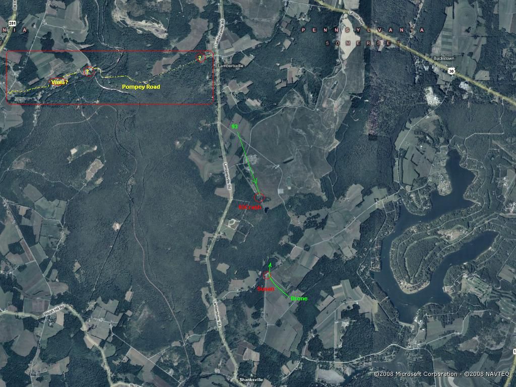
1. Susan McElwain drove in her van south of the crash site on Buckstown Rd, and when she was near the T-junction with Skyline Rd, where she wanted to turn right on Skyline Rd, which would bring her on that road along the crash site to her left, she suddenly saw a little white drone coming from behind (south of her) flying over her van and making a smooth curve to the right, over the tree line in front of her, towards the crash site.
And what Susan saw could be any UAV, even a Predator UAV, one of the other UAV's I gave a group photo of, or any other type which is not online and still kept secret.
The tree line covered her sight of the crash area just behind that tree line, and when she took that right turn onto Skyline Rd, she could see all the way driving home, along that road on her left side the smoke column of the crash in the grassy fields.
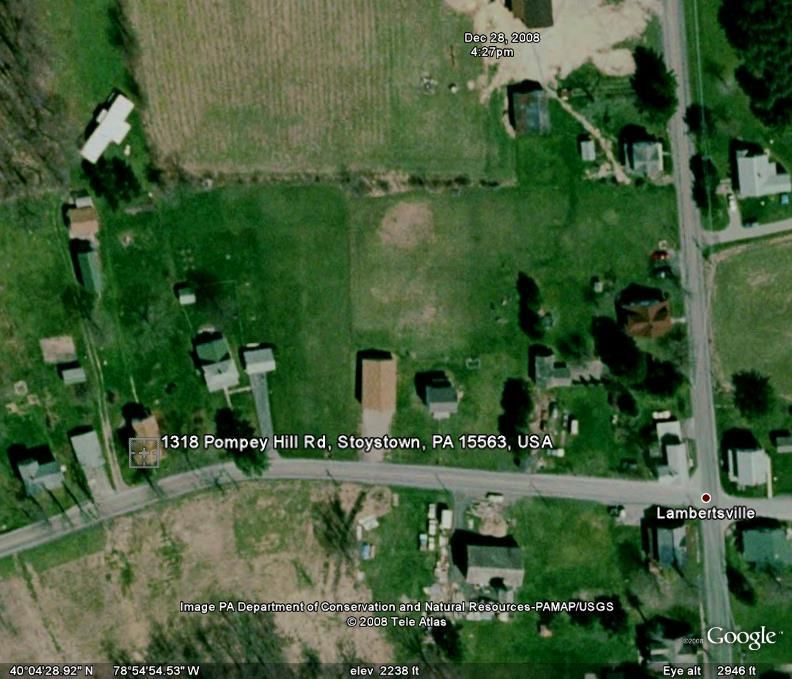
2. Viola Sailor lived very near the road junction in the center of Lambertsville. The eighth house to the west on Pompey Rd. Mr Peterson three houses to the east of the junction. That Lambertsville two roads junction is 1.72 miles from the crash site. And she and her sister saw UAL93 flying upside-down just above her back-garden's Maple tree. That's about 100 feet high.
I posted already multiple times all the links to the threads where I posted long ago already all my calculations based on the FDR, published by the NTSB, and an Italian flight animation based on those FDR data, and which weedwhacker admitted a few posts ago to have found via a link of mine, and then watched that Italian FDR based NTSB data animation, but now he doesn't remember or understand that I also posted one post further on the same page 2 in this "Shanksville" thread how I calculated the exact positions of UAL93, from Lambertsville to the crash site, confirmed by the NTSB data derived from their FDR.
And that was already that long ago calculated by me in a very simple manner, by just counting back from the official point of impact in seconds and miles/knots.
And of course I included into my calculations the probable elevation of the Lambertsville junction above sea level, as you can see in these posts of mine in this thread's page 2. That was quite simple, since the altimeter gave that value, 665 meters or 2182 feet, at the moment of impact, and you said later that the town of Shanksville has an elevation of 2230 feet above sea level, so that's the wrong town, you should have asked for Lambertsville, but 48 feet (1 %) difference on a real height above ground value of 4551 feet at the crash site is by far not the 100 feet Viola says she saw UAL93 thundering just above her head and her Maple tree :
Italian animation, Volo 93 - Animazione NTSB (sintesi) 4a parte by antibufala: :
www.abovetopsecret.com...
First calculations for height of UAL93 above Viola :
www.abovetopsecret.com...
Second preciser calculations for height of UAL93 above Viola :
www.abovetopsecret.com...
Well, well! Here you do it AGAIN :
I just tried in lengthly posts in the "Whistleblower" thread :
www.abovetopsecret.com...
in my first page 6 post; and also in here, to let you understand at last that there is NOT AT ALL any ""disagreement between WHAT SETTING was displayed on the clock, onboard, and the more accurate 'universal' time references that ground sources had"".
I PROVED it to you ad infinitum. You really seem to miss some logic there. The by ATC controllers registered log book times from OUTSIDE THE PLANE, and the ON-BOARD registered times in the CVR for exactly the same audio events, were perfectly synchronous within a human audio-to-text fault margin of max 2 to 3 seconds. CVR and FDR are based on the same plane-internal time instruments.
There was however a VERY STRANGE, 3 minutes = 180 seconds, very long time gap between on-board instruments readings, recovered from thus false FDR and CVR,
and one of the outside of the plane's instruments registered events, registered by radar, ATC log books and seismographs : they ALL said that the plane crashed in reality at 10:06:05 AM.
So we miss the last 3 minutes of that CVR, and FDR.
In those three missing minutes, one ATC'er told the other that suddenly UAL93's transponder came back on, and thus he had new height readings and could give an exact position of UAL93, THREE MINUTES LATER than the official crash time, at 10:06:05 AM, to the east of Indian Lake, when he lost the transponder signal suddenly again.
If he would have given the exact coordinates of the official crash site I could believe in an FDR error, but not now....
And if we thus consider that there were 3 minutes missing from the NTSB released CVR, since all other much preciser timestamped sources (radar, seismic, FAA ATC) report a crash time of 10:06:05 (+/- 5 sec), then there was also 3 minutes missing from their FDR data, and thus that FDR is partly or totally false. (Three (perhaps the last) minutes were thus CUT OUT).
Note especially that the FAA their own ATC Tower reports' timestamps of the spoken communication between the cockpit and the ATC center, and the CVR timestamps of the same cockpit-recorded audible communications, are as good as identical (within a 1% transcription fault margin), and thus running in synchronization.
Thus also the FDR timestamps, since CVR and FDR both are coupled to the Captains clock and if the Captain's clock fails, the First Officer's clock provides these FDR timestamps. And both were set or stood correct before UAL93 departed its gate.
And if you still can't understand this logical reasoning, then I start to suspect that you lack a wish for constructive debate or suffer from an illogical and thus defunct blocked reasoning process, so :
If the on-board CVR and FDR both end at 10:03 AM and all other reliable sources OUTSIDE THE PLANES INSTRUMENTS say it should have ended at 10:06 AM,
then either all of the other outside sources are false, or the plane related sources (FDR + CVR) are false.
It seems that the FDR+CVR are partly or fully falsified, based on:
1.Viola's reporting of a totally different height than the NTSB data, as they say extracted by them from a FBI-handed over FDR box, recovered from the UAL93 crash site,
2. Susan's report of a small UAV just over her van a few seconds before the smoke column rose above the crash site,
3. The 3 minutes discrepancy between the plane's-instruments bound crash time and outside-sources bound crash time, while the Air Traffic Controllers-to-plane communication proved to be synchronous. Thus the crash times should have matched also, which they however did NOT.
GoodolDave likes to act as an Archie Bunker style debater.
I don't mind, and will address his misconceptions in my next post.
Susan McElwain is the one who saw a small white UAV-drone extremely low flying over her van while driving south of the crash site.
And Viola Sailor stood in her house's back-door north of the crash site where she saw three planes, first UAL93, then a big white plane with two "eyeballs on top", and then a white business jet.
You and everybody else seem to mix-up Susan's little white drone just before the crash, with Viola's big white plane with the two "eyeballs on top of that plane" which flew medium high over her, 5 to 10 minutes after she saw UAL93 pass extremely low over her.
We are discussing matters here in such a slow and dense manner since the other participants and especially my opponents keep acting as if I did not address all their arguments already a long time ago. Just check the dates in my following posts-links to two threads. That was two and a half years ago.
It seems necessary that they should re-read the two threads I posted multiple times already links to; namely this thread about Viola, and the other, "Whistleblower Reveals" thread, since I coupled them together for their convenience.
The Whistleblower thread is mainly about the 3 minutes discrepancy between FDR+CVR offered by the NTSB and all other sources outside the plane's instruments, so 10:03 or 10:06 AM crash time.
This "Shanksville" thread is about the reports of 911 told on video by two different women, Viola and Susan.
Let's first make it crystal clear where the female witnesses were and what they saw, before I answer the latest misconceptions and mixing-up about the female witnesses by GoodolDave and weedwhacker, and I just saw also by TrickoftheShade :
1. Susan McElwain drove in her van south of the crash site on Buckstown Rd, and when she was near the T-junction with Skyline Rd, where she wanted to turn right on Skyline Rd, which would bring her on that road along the crash site to her left, she suddenly saw a little white drone coming from behind (south of her) flying over her van and making a smooth curve to the right, over the tree line in front of her, towards the crash site.
And what Susan saw could be any UAV, even a Predator UAV, one of the other UAV's I gave a group photo of, or any other type which is not online and still kept secret.
The tree line covered her sight of the crash area just behind that tree line, and when she took that right turn onto Skyline Rd, she could see all the way driving home, along that road on her left side the smoke column of the crash in the grassy fields.
2. Viola Sailor lived very near the road junction in the center of Lambertsville. The eighth house to the west on Pompey Rd. Mr Peterson three houses to the east of the junction. That Lambertsville two roads junction is 1.72 miles from the crash site. And she and her sister saw UAL93 flying upside-down just above her back-garden's Maple tree. That's about 100 feet high.
I posted already multiple times all the links to the threads where I posted long ago already all my calculations based on the FDR, published by the NTSB, and an Italian flight animation based on those FDR data, and which weedwhacker admitted a few posts ago to have found via a link of mine, and then watched that Italian FDR based NTSB data animation, but now he doesn't remember or understand that I also posted one post further on the same page 2 in this "Shanksville" thread how I calculated the exact positions of UAL93, from Lambertsville to the crash site, confirmed by the NTSB data derived from their FDR.
And that was already that long ago calculated by me in a very simple manner, by just counting back from the official point of impact in seconds and miles/knots.
And of course I included into my calculations the probable elevation of the Lambertsville junction above sea level, as you can see in these posts of mine in this thread's page 2. That was quite simple, since the altimeter gave that value, 665 meters or 2182 feet, at the moment of impact, and you said later that the town of Shanksville has an elevation of 2230 feet above sea level, so that's the wrong town, you should have asked for Lambertsville, but 48 feet (1 %) difference on a real height above ground value of 4551 feet at the crash site is by far not the 100 feet Viola says she saw UAL93 thundering just above her head and her Maple tree :
Italian animation, Volo 93 - Animazione NTSB (sintesi) 4a parte by antibufala: :
www.abovetopsecret.com...
First calculations for height of UAL93 above Viola :
www.abovetopsecret.com...
LaBTop : We determined the distance from Viola's house to the crash site (in Google Maps) to be 1.72 miles.
Some speed and height values on the meter in the last 12 seconds before impact.
Speed is in knots, height is in feet above sea level, so we must subtract the average height of the terrain in the last 15 seconds, which is minimum 665 meters or minimum 2182 feet.
We start with the values read on-screen at 12 seconds before impact, I added the ft/ground values by subtracting 2182 feet from the ft/sea on-screen values :
Second preciser calculations for height of UAL93 above Viola :
www.abovetopsecret.com...
LaBTop : We now look at the newly found moment of crossing of the plane above Viola's house, that's 16 seconds before the 10:03:07 impact position, which is 10:02:52.
We note the air speed and height above sea level readings in the Italian NTSB animation.
We register 383 knots speed, and 6733 ft above sea level, which is (minus 2182 feet) 4551 ft above local ground level (x 0.3048) is 1387 meter above Lambertsville junction's ground level, even higher than we first assumed.
That NTSB plane flew 1387 meters above Viola, while she insists it flew just above her, not more than 30 to 40 meters.(100 feet)
Well, well! Here you do it AGAIN :
weedwhacker :
There is a THREE MINUTE DISCREPANCY...a disagreement between WHAT SETTING was displayed on the clock, onboard, and the more accurate 'universal' time references that ground sources had.
I just tried in lengthly posts in the "Whistleblower" thread :
www.abovetopsecret.com...
in my first page 6 post; and also in here, to let you understand at last that there is NOT AT ALL any ""disagreement between WHAT SETTING was displayed on the clock, onboard, and the more accurate 'universal' time references that ground sources had"".
I PROVED it to you ad infinitum. You really seem to miss some logic there. The by ATC controllers registered log book times from OUTSIDE THE PLANE, and the ON-BOARD registered times in the CVR for exactly the same audio events, were perfectly synchronous within a human audio-to-text fault margin of max 2 to 3 seconds. CVR and FDR are based on the same plane-internal time instruments.
There was however a VERY STRANGE, 3 minutes = 180 seconds, very long time gap between on-board instruments readings, recovered from thus false FDR and CVR,
and one of the outside of the plane's instruments registered events, registered by radar, ATC log books and seismographs : they ALL said that the plane crashed in reality at 10:06:05 AM.
So we miss the last 3 minutes of that CVR, and FDR.
In those three missing minutes, one ATC'er told the other that suddenly UAL93's transponder came back on, and thus he had new height readings and could give an exact position of UAL93, THREE MINUTES LATER than the official crash time, at 10:06:05 AM, to the east of Indian Lake, when he lost the transponder signal suddenly again.
If he would have given the exact coordinates of the official crash site I could believe in an FDR error, but not now....
And if we thus consider that there were 3 minutes missing from the NTSB released CVR, since all other much preciser timestamped sources (radar, seismic, FAA ATC) report a crash time of 10:06:05 (+/- 5 sec), then there was also 3 minutes missing from their FDR data, and thus that FDR is partly or totally false. (Three (perhaps the last) minutes were thus CUT OUT).
Note especially that the FAA their own ATC Tower reports' timestamps of the spoken communication between the cockpit and the ATC center, and the CVR timestamps of the same cockpit-recorded audible communications, are as good as identical (within a 1% transcription fault margin), and thus running in synchronization.
Thus also the FDR timestamps, since CVR and FDR both are coupled to the Captains clock and if the Captain's clock fails, the First Officer's clock provides these FDR timestamps. And both were set or stood correct before UAL93 departed its gate.
And if you still can't understand this logical reasoning, then I start to suspect that you lack a wish for constructive debate or suffer from an illogical and thus defunct blocked reasoning process, so :
If the on-board CVR and FDR both end at 10:03 AM and all other reliable sources OUTSIDE THE PLANES INSTRUMENTS say it should have ended at 10:06 AM,
then either all of the other outside sources are false, or the plane related sources (FDR + CVR) are false.
It seems that the FDR+CVR are partly or fully falsified, based on:
1.Viola's reporting of a totally different height than the NTSB data, as they say extracted by them from a FBI-handed over FDR box, recovered from the UAL93 crash site,
2. Susan's report of a small UAV just over her van a few seconds before the smoke column rose above the crash site,
3. The 3 minutes discrepancy between the plane's-instruments bound crash time and outside-sources bound crash time, while the Air Traffic Controllers-to-plane communication proved to be synchronous. Thus the crash times should have matched also, which they however did NOT.
GoodolDave likes to act as an Archie Bunker style debater.
I don't mind, and will address his misconceptions in my next post.
Okay, sorry, I thought you were talking about Viola Saylor above.
So she says she saw another plane. I'm not sure what this proves.
So she says she saw another plane. I'm not sure what this proves.
reply to post by LaBTop
Sorry...you are STILL trying to make the claim that the DFDR and CVR were somehow "faked"....it is now up to you to provide some sort of evidence for that claim.
Just as the CSV files were obtained for the American 77 DFDR, they should be available for United 93's.
You must show how the over two hundred separate values and inputs could have been "faked" to such extent that those who make their living analyzing these things didn't notice any anomalies.
It would be illuminating to pay particular attention to the values ascribed to the various accelerometers that are present on such an airplane...those readings are also sampled by the DFDR. Because, as some in the past have claimed....THEY think that these flight maneuvers could be done in a full motion simulator, and then 'recorded' as if they occurred on a real flight --- and that is nonsense, of course. There is a big difference between the software and programming that simulates flight, and how the real thing is recorded and stored as data.
Several references have been made to the NTSB animaiton of UAL 93's final few minutes...when I watch it (will repeat it below) it looks exactly as I would expect...the extreme maneuvering attempts by the suicide bombers (for that's essentially what they were) starting at ~09:58:00 EDT in the video's airplane time reference.
Watch the motions of the control wheel, in roll inputs, and also a bit later, when the extreme pitching movements were started. (BTW...here would be more use for the accelerometers' readings, as the G forces would show increased positive on pitch ups, and less to possible close to zero -- or negative -- on the pitch downs. Values of substantially LESS THAN ONE G cannot be duplicated in a simulator that is mounted in a building on the ground, obviously!! The military has some very advanced sims for some of their fighters, and they are capable large-scale drops, to simulate momentary less-than-1-G...but they are limited by range of motion. A B-757/767 sim can 'drop' slightly, but only a few feet...the hydraulic struts supporting the unit just can't reproduce exactly what is felt in real flight. What id does, though, is 'fool' the senses in other ways, and by watching the instruments, or the outside 'visuals', the pilot is given a fairly convincing 'show'...).
Back to the control wheel movements....you will see the extreme 'stop-to-stop' fluctuations that were made (There is only about 90 degrees from centered, either side, in the roll command authority of the control wheel).
But, as is the case in real life, the airplane's response to those extreme inputs is slightly delayed. Inertia at work.
Here...I have found another NTSB Flight Recorder animation recreation, this for American Airlines flight 1420, an MD-80 that crashed during a landing attempt at Little Rock Arkansas. (Interestingly, a management pilot/check airman was flying this...he was giving instruction to a new First Officer recently hired...this is normal as part of the final training curricula, an 'on-the-job' finishing up. Watch the control wheel movements, in relation to the airplane's responses in attitude changes. It was very gusty, and there was a great deal of turbulence from the existing weather conditons):
Here again is UAL 93, from the Italian group's post, part 4a:
The extreme control wheel movements in the UAL 93 case were for different reasons than the AAL 1420 flight's...but note the airplane's reactions are similar.
I posted the AAL 1420 video as an example, for those that believe the UAL 93 data was somehow "faked".
I would refer people back, up thread, to the link for the NTSB report, shows graphical chart-format depiction of altitude, airspeed, vertical speed, heading, etc.
Originally posted by LaBTop
TrickoftheShade, are you also confusing Susan McElwain's remarks with Viola Sailor's? (Just as GoodolDave and weedwhacker keep doing again and again.)
I try to refrain from personal attacks becuase it does nothing to advance the topic of discussion, but in this case there's no way around it- you, sir, are a pathological liar. I sad TWICE that I am specifically quoting these people's own eyewitness testimony. Viola Saylor's video linked by the op specifically says she saw a very loud plane flying upside down over her proeprty which crashed shortly afterwards (which matches the account of flight 93 to a T), and Susan McElwain specifically said in the Bergan record interview that the plane she spotted had two external engines and a spolier like a race car (which matches none of your fanciful suppositions). Why you are attempting to reinvent their eyewitness accounts to your liking when we have such easy access to the original material is beyond me.
It's as if whenever you encounter anything that disproves your conspiracy claims, you simply pretend that it doesn't exist.
See for a detailed description of what Viola Saylor told us on video what she saw, and how many planes she saw (THREE), within a 10 minutes timeframe; a past post of mine on page one in this same thread.
Here is my post regarding what Viola Saylor said in her interview with Domenick DiMaggio :
It makes no difference whether she saw one plane, three planes, or thirty planes. The debate is over whether *any* of the planes she had seen was flight 93, and the very loud, upside down flyign plane that crashed was almost certainly it. We have testimony that shows ground controllers were directing nearby aircraft into the area to look for signs of a crash site, so the fact that there could have been additional planes in the air at the time than just the one is a sinister revelation only to you.
In my opinion, when I read her description of the second plane coming from the south, I immediately think of an E-4B "Doomsday" plane, which were all four in the air on 911 for all these military exercises, two of them were definitely flying around the Washington/Pentagon theater, and where the other two were, I have never found out.
One is normally and especially in an "Attack on America" situation, always near the presidential plane, "Air Force One". They can stay for many days airborne, while being re-fueled in the air.
You conspiracy mongers are notorious for playing innuendo games where you make all kinds of disgusting accusations without actually coming out and saying them to give yourselves plausible deniability, so before I comment, I want verification for your true meaning- so you think the plane that actually crashed was an E-4B and the genuine flight 93 was disposed of elsewhere?
Good grief, it's as if you actually hope there IS some secret sinister conspiracy afoot here.
Originally posted by LaBTop
1. Susan McElwain drove in her van south of the crash site on Buckstown Rd, and when she was near the T-junction with Skyline Rd, where she wanted to turn right on Skyline Rd, which would bring her on that road along the crash site to her left, she suddenly saw a little white drone coming from behind (south of her) flying over her van and making a smooth curve to the right, over the tree line in front of her, towards the crash site.
...to which I'm replying... AGAIN...that this account fits no drone in the US arsenal nor does it even fit the laws of physics. Any drone as large as her van...or no larger than her van, depending on how you interpret her account... will have to be going at a pretty good clip to stay in the air. Your own link showed the predator drone stalls at 60 mph. There's no way any craft flying faster that 60MPH with the bulk of a van sized object will be able to "make a smooth curve to the right" from where she said she was at that T intersection, particularly if it was flying lower than 25 feet and especially if it was a fixed wing craft. The laws of physics have to apply to your conspiracies just as they do to everything else.
...and just what in the name of Ronald McDonald does this have anything to do with anything to begin with? This was clearly NOT the upside down, very loud crashing-into-the-ground plane that Viola Saylor saw which almost certainly was flight 93, meaning that the plane McElwain saw was a whole other plane that had nothign to do with flight 93. The identity of this second plane does nothing to advance our understanding of what happened to flight 93 so arguing over whether the secondary craft Susan McElwain saw was a drone, a model airplane, or a UFO from the planet Nudnig IV is entirely an argumentative red herring on your part.
GoodolDave, don't pop a vain about some of your own misunderstandings regarding my position on Flight 93, that would left me with only one opponent,
and life would be less interesting again. Btw, I am a rabid fan of the Archie Bunker series, so don't misunderstand my remark about you in a past
post.
I have many times repeated in this forum, that without a good opposition, this forum dies a silent death within a few months, so it should be clear as crystal that I appreciate civil, proper, intelligent opposition, and as you can ask your forum friends, when you can convince me that my opinion is wrong, I will gallantly tell you in public that I was and am wrong.
One example lately was the Flight 77 witness statement of Roosevelt Roberts, which at last, after about 100 times listening to his audio files, I became aware that he was no fly-over witness at all, and I have expressed that feeling quite clear to my fellow 911 conspiracy believers. I still believe however unconditionally in all the other North of Citgo Flight 77 witnesses.
You seem not to understand where I am trying to lead you two towards.
I also believe, just as you, that Viola saw UAL93, upside down flying. I also believe there is a great possibility that UAL93 ditched in that hole in that old, refilled, once open surface coal-mine.
But I do believe following studying old photos of that open coal mine that it ditched in the old, original hard side wall of that once open pit, and not in the soft refill soil inside the earlier mine. The old cut away side of the deep open mine was much further southwards than the crash spot, which was very near to that gravel path where you can see the first responder vehicles parked. Just watch the old USGS photos and compare the width of that double ditch that still is present, to the right side of the crash hole.
I am always looking at pieces of a puzzle which do not fit too well, but especially the ones which do not fit at all.
And in this case, that's Viola's explicit remark about the height at which she saw UAL93 flying over her property, and my calculation of the height that the NTSB wants us to believe it flew above her at that moment during its flight.
I calculated that it took UAL93 about 16 seconds to reach its destiny, according to the NTSB data from the FDR they got handed over by the FBI. Even when you take 10 seconds off that time, the plane was still much to high in the NTSB data list, to even come near to Viola's maple tree height of no more than 100 feet.
I am only at the point of answering this page 7 its first post of yours, and was looking at this sentence of yours :
You perhaps got that from the post from Shadow Herder on page 3 :
www.abovetopsecret.com...
He gave a good History Commons link to Susan McElwain with as usual a lot of newspaper links :
www.historycommons.org...
Susan did however not say that in the linked to Bergen Record interview. I found only one outside source copy of that Bergen Record article here, the original one is gone :
s3.amazonaws.com...
There is no conclusive evidence that she ever described that drone as an A-10, in my opinion, since she certainly had enough time in the video interview from Ettaro and DiMaggio, to come up herself with such a perfect description for the viewer of her interview, but she didn't.
She however gave a totally different description of a SILENTLY flying, white, smoothly molded very small UAV, with no rivets at all, no wider or bigger as her van.
That sounds to me as a Lithium Ion driven electrical power-plant in a plastic or Kevlar ultralight UAV, of which you can find several photo's in that UAV group photo which I posted in page 6. One strong electro motor can easily drive two propellers.
I forgot to fit that photo to forum rules, so here is the original source photo link, so you can have a look at the one to the far right :
Ultralight UAV's.

An A-10 Warthog however, is a very loud plane, which does not fit her actual description in the Bergen Record article and especially her own words in her Attaro/DiMaggio video, at all.
I have the strong feeling that the Mirror piece which is linked to after the Bergen Record link in that History Commons article link, with that perfect description of an A-10, is a prime example of simple disinformation spread to an eagerly waiting press.
And I have much more faith in Susan's own descriptive words, than the story of a Mirror tabloid reporter, which comes from another linked to article :
www.mirror.co.uk..." target="_blank" class="postlink"> The Mirror article with the A-10 description by Susan McElwain
web.archive.org...://www.mirror.co.uk/news/allnews/page.cfm?objectid=12192317&method=full
Those two guys, Dennis Decker and Rick Chaney could have seen the Fairchild Falcon 20 business jet, but so soon after the UAL93 crash, it does not fit the time line description of the third plane seen by Viola Saylor, since she saw it for the first time, 5 to 10 minutes after the UAL93 crash, coming at high altitude (thus not low and fast) from the north, just after the second bigger white plane she saw coming from the south at medium high altitude, with the two eyeballs on top and swept-back wings, a perfect description of a 747 E-4B Doomsday plane, white, bigger than a 757 with two domes on top.
The Falcon could have made a full circle already of course. However, I do not think that it did that already, since the ATC controller asked him to check things out after he was quite sure that UAL93 did probably crash. Which took time to check out for that controller, a few minutes at least. And don't forget, radar data which is used by that ATC'er, gave a 10:06 time for the second loss of the transponder, and the supposed crash.
But we have no reports of a crashed airplane at those coordinates given by the controller who found for the second time UAL93's transponder signal back. Logic tells us then that UAL93 must thus have flown away from those coordinates, but now again without transponder, after 10:06.
But until I see an interview with those two ATC'ers, I can't see this as conclusive evidence. The Pilots for Truth did not give a link to a source, as far as I know.
I will delve into that too, it is far too important to leave it by just a remark, I hope they will have such a breaking news fact sourced.
More posts coming to answer all next posts after GoD post.
[edit on 3/7/10 by LaBTop]
I have many times repeated in this forum, that without a good opposition, this forum dies a silent death within a few months, so it should be clear as crystal that I appreciate civil, proper, intelligent opposition, and as you can ask your forum friends, when you can convince me that my opinion is wrong, I will gallantly tell you in public that I was and am wrong.
One example lately was the Flight 77 witness statement of Roosevelt Roberts, which at last, after about 100 times listening to his audio files, I became aware that he was no fly-over witness at all, and I have expressed that feeling quite clear to my fellow 911 conspiracy believers. I still believe however unconditionally in all the other North of Citgo Flight 77 witnesses.
You seem not to understand where I am trying to lead you two towards.
I also believe, just as you, that Viola saw UAL93, upside down flying. I also believe there is a great possibility that UAL93 ditched in that hole in that old, refilled, once open surface coal-mine.
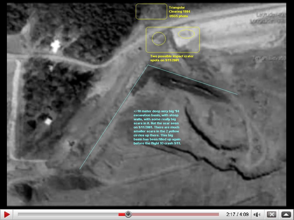
But I do believe following studying old photos of that open coal mine that it ditched in the old, original hard side wall of that once open pit, and not in the soft refill soil inside the earlier mine. The old cut away side of the deep open mine was much further southwards than the crash spot, which was very near to that gravel path where you can see the first responder vehicles parked. Just watch the old USGS photos and compare the width of that double ditch that still is present, to the right side of the crash hole.
I am always looking at pieces of a puzzle which do not fit too well, but especially the ones which do not fit at all.
And in this case, that's Viola's explicit remark about the height at which she saw UAL93 flying over her property, and my calculation of the height that the NTSB wants us to believe it flew above her at that moment during its flight.
I calculated that it took UAL93 about 16 seconds to reach its destiny, according to the NTSB data from the FDR they got handed over by the FBI. Even when you take 10 seconds off that time, the plane was still much to high in the NTSB data list, to even come near to Viola's maple tree height of no more than 100 feet.
I am only at the point of answering this page 7 its first post of yours, and was looking at this sentence of yours :
I am quoting Susan McElwain who said in a previous interview with the Bergen Record (which every 9/11 conspiracy web site accepts as legitimate) that the craft had "two rear engines, a big fin on the back like a spoiler on the back of a car and with two upright fins at the side."
You perhaps got that from the post from Shadow Herder on page 3 :
www.abovetopsecret.com...
He gave a good History Commons link to Susan McElwain with as usual a lot of newspaper links :
www.historycommons.org...
Susan did however not say that in the linked to Bergen Record interview. I found only one outside source copy of that Bergen Record article here, the original one is gone :
s3.amazonaws.com...
Susan Mcelwain of Stonycreek Township said a small white jet with rear engines and no discernible markings swooped low over her minivan near an intersection and disappeared over a hilltop, nearly clipping the tops of trees lining the ridge.
It was less than a minute later, Mcelwain said, that the ground shook and a white plume of smoke appeared over the ridge. "It was so close to me I ducked," Mcelwain said. "I heard it hit and saw the smoke. All I could think of was how close I came to dying. " About a mile north on Buckstown Road, Dennis Decker and Rick Chaney were at work making wooden pallets when they heard an explosion and came running outside to watch a large mushroom cloud spreading over the ridge.
"As soon as we looked up, we saw a midsized jet flying low and fast," Decker said. "It appeared to make a loop or part of a circle, and then it turned fast and headed out. " Decker and Chaney described the plane as a Lear-jet type, with engines mounted near the tail and painted white with no identifying markings.
"If you were here to see it, you'd have no doubt," Decker said. "It was a jet plane, and it had to be flying real close when that 757 went down.
There is no conclusive evidence that she ever described that drone as an A-10, in my opinion, since she certainly had enough time in the video interview from Ettaro and DiMaggio, to come up herself with such a perfect description for the viewer of her interview, but she didn't.
She however gave a totally different description of a SILENTLY flying, white, smoothly molded very small UAV, with no rivets at all, no wider or bigger as her van.
That sounds to me as a Lithium Ion driven electrical power-plant in a plastic or Kevlar ultralight UAV, of which you can find several photo's in that UAV group photo which I posted in page 6. One strong electro motor can easily drive two propellers.
I forgot to fit that photo to forum rules, so here is the original source photo link, so you can have a look at the one to the far right :
Ultralight UAV's.
An A-10 Warthog however, is a very loud plane, which does not fit her actual description in the Bergen Record article and especially her own words in her Attaro/DiMaggio video, at all.
I have the strong feeling that the Mirror piece which is linked to after the Bergen Record link in that History Commons article link, with that perfect description of an A-10, is a prime example of simple disinformation spread to an eagerly waiting press.
And I have much more faith in Susan's own descriptive words, than the story of a Mirror tabloid reporter, which comes from another linked to article :
www.mirror.co.uk..." target="_blank" class="postlink"> The Mirror article with the A-10 description by Susan McElwain
web.archive.org...://www.mirror.co.uk/news/allnews/page.cfm?objectid=12192317&method=full
Those two guys, Dennis Decker and Rick Chaney could have seen the Fairchild Falcon 20 business jet, but so soon after the UAL93 crash, it does not fit the time line description of the third plane seen by Viola Saylor, since she saw it for the first time, 5 to 10 minutes after the UAL93 crash, coming at high altitude (thus not low and fast) from the north, just after the second bigger white plane she saw coming from the south at medium high altitude, with the two eyeballs on top and swept-back wings, a perfect description of a 747 E-4B Doomsday plane, white, bigger than a 757 with two domes on top.
The Falcon could have made a full circle already of course. However, I do not think that it did that already, since the ATC controller asked him to check things out after he was quite sure that UAL93 did probably crash. Which took time to check out for that controller, a few minutes at least. And don't forget, radar data which is used by that ATC'er, gave a 10:06 time for the second loss of the transponder, and the supposed crash.
But we have no reports of a crashed airplane at those coordinates given by the controller who found for the second time UAL93's transponder signal back. Logic tells us then that UAL93 must thus have flown away from those coordinates, but now again without transponder, after 10:06.
But until I see an interview with those two ATC'ers, I can't see this as conclusive evidence. The Pilots for Truth did not give a link to a source, as far as I know.
I will delve into that too, it is far too important to leave it by just a remark, I hope they will have such a breaking news fact sourced.
More posts coming to answer all next posts after GoD post.
[edit on 3/7/10 by LaBTop]
GoodolDave : still commenting on that same post, slowly advancing.
1. (""which matches the account of flight 93 to a T)""
No, it doesn't match it at all, UAL93 flew 1.2 km higher than Viola's house,when we should believe the NTSB's FDR data, which I do not btw.
I believe Viola Saylor.
2. ""Ah yes, the "they custom invented new James Bond technology that no one has ever seen before or since" excuse. I know it well, as it's the same excuse that the conspiracy people come up with to explain every other fanciful explanation they provide. Problem is, it's just another way of saying you're just making up horse [censored] off the top of your head as you go along. ""
I constructed large (+3 meter wide) ultralight airframes already in the 1950ies with my friends from the local model building club. And they flew very slow, since we made them from balsa wood and strong paper sheets.
The biggest ones had Rotax or lawnmower motors to propel them.
Later we got the first beautiful Wankel model motors, vibration-free.
And then came the turboprop and jet powered ones.
We constructed already the large delta winged model planes.
Large electric motor systems were too heavy then for large model planes, and lasted too short, but since then we invented the Lithium Ion batteries, and the Hydrogen gas driven ones.
Nowadays the military rediscovered all our work from the last century, and all that mattered were new materials like molded plastics/Kevlar/carbon materials for the fuselage and wings of UAL's.
I promised to give you that photo from the Amalgam Virgo exercise from June 2000, here is the photo:
[atsimg]http://files.abovetopsecret.com/images/member/8a53de05f450.jpg[/atsimg]
I meant the white ultralight reconnaissance UAV at the upper left corner, and not that red target-practice missile under it that GoD used to get winded up on an "Archie Bunker-rant" again.
3. ""I'm more than happy to go by Viola Saylor's spot-on eyewitness account that it was flight 93 that she saw crash.""
She did not see it crash.
And you do not see the great problem you have when you believe she saw flight 93, but you think she's nuts when she strongly stands by her seeing it fly by at maple-treetop height.
And she did not see it fly at 1.2 km high as the FlightDataRecorder says.
Here is that 1994 USGS photo from the old open pit mining operation.
And I added some of my comments which you can only read when you view it full-screen, thus first the link to the original photo size :
Click for big, clear picture.
And here is Viola Saylor's house, the sixth to the west of the Lambertsville junction, and you can clearly see the two maple trees in her backyard :
Click for big, clear picture.
And this is an overview of the positions of both women, Viola and Susan on 9.11.2001, flight 93 crash site, and the path of the little white drone over Susan's car.
Viola's house is at the first question mark near the name "Lambertsville" on this map :
Click for big, clear picture.
Am really busy answering the next posts, so please be patient.
[edit on 3/7/10 by LaBTop]
reply to post by LaBTop
LaBToP
I wasn't going to point out the photo you posted before, but since you did a second time...I feel I must:
If you 'google' the phrase "2005 Naval Unmanned Aerial Vehicle Air Demo" You will get this website:
www.defense.gov...
As you can see, the event was held (not too far from me, actually) at the Patuxent Naval Air Station, in Maryland, USA.
What the above photo is showing are a bunch of Radio Control models...(I should know, since it is a hobby of mine). The largest model in that photo? One in back? I would guess a wingspan of eight to (max) ten feet. That is considered 'large scale' in the R/C hobby parlance...
Look here, with a human in the photo for size perspective:
www.defense.gov...
Looks very much like the model second from the right, foreground....
In that photo, with all the models arranged on the runway, consider that the runway they are "posing" on is 100 feet wide --- if that helps you with additional sense of scale.
(The airport's ICAO code is 'KNUI'. It is located in St. Inigoes, Maryland. Typically for small airports like that, with a 5,000-foot runway length, it is 100 feet wide. Larger airports where commercial jets operate will have runways of 150 feet to 200 feet width).
KNUI satellite image
[edit on 3 July 2010 by weedwhacker]
LaBToP
I wasn't going to point out the photo you posted before, but since you did a second time...I feel I must:
...so you can have a look at the one to the far right :
If you 'google' the phrase "2005 Naval Unmanned Aerial Vehicle Air Demo" You will get this website:
www.defense.gov...
As you can see, the event was held (not too far from me, actually) at the Patuxent Naval Air Station, in Maryland, USA.
What the above photo is showing are a bunch of Radio Control models...(I should know, since it is a hobby of mine). The largest model in that photo? One in back? I would guess a wingspan of eight to (max) ten feet. That is considered 'large scale' in the R/C hobby parlance...
Look here, with a human in the photo for size perspective:
www.defense.gov...
Looks very much like the model second from the right, foreground....
In that photo, with all the models arranged on the runway, consider that the runway they are "posing" on is 100 feet wide --- if that helps you with additional sense of scale.
(The airport's ICAO code is 'KNUI'. It is located in St. Inigoes, Maryland. Typically for small airports like that, with a 5,000-foot runway length, it is 100 feet wide. Larger airports where commercial jets operate will have runways of 150 feet to 200 feet width).
KNUI satellite image
[edit on 3 July 2010 by weedwhacker]
Weedwhacker, you do know that all the military UAV's were derived from older model planes? The Israeli's were the first to get interested in their
usefulness, and developed the first working ones with a satellite up-, and down link, and video reconnaissance capabilities.
They just scaled up the existing model planes and upgraded some features. Nowadays they are weaponized as you know.
Do you understand the implications of Susan's drone sighting? She saw a small, slow, low plane; a model one or an UAV, that's not so important how you call it, it was flying fairly slow and very low and it was about the size of her van.
Did you think the implications of such a sighting through to the inevitable end conclusions?
You have a few things to consider then :
1. A slowly and very low flying, smoothly white painted, carbon-fiber molded, small and silent airplane is seen by Susan McElwain, coming from behind her, while it was also following Bridge Road, up to the T-junction crossing with Buckstown Road. That's just south of the crash site. See my map and drawings on it in my last post above.
2. Could be a model-plane or a military UAV, or a CIA owned UAV or a foreign agency owned UAV.
Which entities all or separately, perhaps had interests for future political power-play blackmail schemes, and wanted to record what happened?
Since 911 must have been planned in advance, when such a slow drone suddenly appears on the 911 scene within seconds of the crash.
But then we must take it as a certainty, that the fate and position of UAL93 was planned deliberately far in advance, and these agencies got their hands on a copy of the already existing 911 script book.
Strong suspicion of such a future blackmail scheme is the SLOW speed of the drone and its very low height, reported by Susan. She said that within no more than 60 seconds after the drone hopped over the tree line in front of her, the smoke column rose up in the air. That means that the crash time and the position must have been EXACTLY planned.
If, it was a slow, low flying ultra light UAV.
But when you view Susan's whole 30 minute video interview, one gets the impression that she knows very well how to explain what she saw.
3. Susan saw a smoke column rising behind the tree line along Buckstown Road, then, when she took the right turn and drove home, she saw that smoke column originating from the official UAL93 crash site, all the way on her trip home to her left side.
4. Two ATC controllers had a conversation about one of them registering UAL93's transponder signal again at 10:05 AM, and thus having all the associated readings back on his screen again, like height (8,200 feet!!!), distance, rate of descent and flight path heading during the short time (circa one minute) the signal was on again. He lost it again at 10:06 AM, and gave the exact geographical coordinates to his ATC colleague for the moment he lost track again :
39°51'0.00'' N and 78°46'0.00'' W.
He did not give the height! I will come to that later on.
5. This is a post from the Google Earth Community-Forums from 09/09/2006 (that's 4 years ago already) :
bbs.keyhole.com...
It's the Indian Lake Airpark (5G2) Central City, PA which is situated just 0.5 mile east of Indian Lake, where all that debris rained down on the marinas and on the fishermen on the lake. And then we have another debris site cordoned off by the FBI on 911, 8 miles from the official crash site, near New Baltimore.
It is however not at all the coordinates that the ATC'er gave for the last known position of UAL93, that's much more southeast!
So, how did this person got to his remark, makes me wonder.
6. This is looking straight down onto the Flight 93 crash site. North is to the top. Note the impact point north of the road, and the burned trees to the south of it. On the left side of this aerial photo you see the two perpendicular ditches you can see in the big 1994 USGS-photo I linked to in my last post.
It's clear that the crash spot is definitely not in the soft refilled soil but instead in the original soil just beside the gravel road.
=========================
Ok, also found that link to the official transcription of the last known position of UAL93 from the Pilots for 911 Truth forum by member Woody Box :
Board message :
pilotsfor911truth.org...
Thread started by Woody Box :
pilotsfor911truth.org...
Flight Data Recorder Transcript of ATC communications. Scroll to page 29 and 30 to look at the last time ATC found the 93-transponder back :
www.scribd.com...
It can take some time to load these pages from Scribd.
At the first position when the transponder came on again at 1405 UTC (10:05 EST), the height reported by that transponder was 8200 feet.
At 1406 UTC (10:06 EST) they lost that transponder contact again.
They did not give a height at that moment!
But they talked on about the last heading of 140°, and pondered on, that it would take the plane then just west of Dulles Airport in the end.
So I wonder if this means that the plane was still at that same height of about 8,000 feet, as reported earlier on already by a vfr (another pilot) around 09:57 AM, who said it was waving/rocking its wings at 8,000 feet high, and 8,000 feet reported also by the transponder when it briefly (1 min) came on again at 10:04.
Logic tells us, that if the last height reported by the last transponder signal was much lower than 8,000 feet, those two ATC'ers would not go on contemplating about where it would end the flight, and even proposed a landing spot just west of Dulles Airport. They would have shouted that they lost signal at a very low height and that it was going to crash. But such a nervous conversation did not happen at all in reality!
I (or another member?) will eventually try to calculate speeds along the flight path based on times and positions reported in the Scribd list by those two ATC'ers, and see if they match the NTSB speed diagram, see the link in my above post :
- At 09:56 : They tracked UAL93 until they lost it at 09:56 right above Pittsburgh. The crash site is about 60 miles southeast of Pittsburgh.
- At 09:57 the plane was 20 miles (NM?) northwest of Johnstown Airport, as reported by another plane's pilot.
- At 10:00 the ATC'er gives another sort of position reported by that vfr (visual flight report) pilot at 09:57 :
Eleven, so 11 miles south of Indian Head and just north of Cumberland, Maryland.
- Page 28 : 10:03 AM Secret Services called and said there was another plane coming from Pittsburgh inbound for Washington DC that's unaccounted for. American 77 says one ATC'er to the other.
- 10:04 AM : Indiana State police reports a plane down just between the boundary of Ohio and Kentucky, the Cincinnati area.
(I don't know what to make from that.?.They also waited on confirmation)
- 10:05 AM : Unknown (Secret Service man?), says they know about 93 already.
- 10:05 AM : Transponder on again, 8,200 feet and still southbound.
- 10:06 AM : Lost radar contact (is that for sure the transponder?).
- 10:07 AM : Sixteen (16) miles south of Johnstown they said they lost radar contact with UAL93 and it was heading turning one four zero heading.
"" Which will put him to what do you think? ""
"" Uh I guess that put him down coming right just west of Dulles.
If he stays on that heading of course."
Thus I think I found something what has not been taken in consideration by the members and pilots from Pf911T.
At 10:07 EST the ATC'er remarks that they lost contact when the plane was 16 south of Johnstown (airport) and it was heading turning one four zero. Do they mean turning to 140° on a compass scale, or what does "heading turning" mean between one ATC and another ATC (or pilots).
And is 16 south in miles or nautical miles? I guess NM.
You can see back in one of my posts in the NTSB diagram from their 93 flight path, that the plane made a wide quarter circle till down south at the end.
When you measure in Google Earth the distance from Johnstown Cambria County Airport (JST) to the official crash site, you find it to be 18.66 miles = 16.21 Nautical miles.
The distance however from JST to that position given by the ATC'er for the moment he lost contact with the transponder for the last time, is far more, 39°51'0.00 N 78°46'0.00 W, and that's 32.36 miles = 28.12 Nautical miles (further southeast) from the crash site. Nearly two times further away in nautical miles. In a very desolated spot, see for yourself in Google Earth. Just fill in the above coordinates in Search.
Thus, the questions which arise now, are :
1. How can an experienced ATC'er give two data which exclude each other COMPLETELY, namely a rather precise last known geographical position in degrees, compared to a distance from JST in nautical miles?
Which do not fit each other by any means!
2. Could UAL93 dive from 8,200 feet at a 40° angle to the ground within 60 seconds, without breaking apart in mid air?
I think it could, but I did not look into the mechanical aspects of its resulting speed over that 40° trajectory related to its airframe endurance, yet.
3. They lost contact again at 10:06 EST, and talk on a bit about the heading at 10:07 EST, and the point where it then will come down, just west of Dulles Airport. They would not do that when the height reading and rate of descent at the last transponder loss time wasn't about the same as before.
They just scaled up the existing model planes and upgraded some features. Nowadays they are weaponized as you know.
Do you understand the implications of Susan's drone sighting? She saw a small, slow, low plane; a model one or an UAV, that's not so important how you call it, it was flying fairly slow and very low and it was about the size of her van.
Did you think the implications of such a sighting through to the inevitable end conclusions?
You have a few things to consider then :
1. A slowly and very low flying, smoothly white painted, carbon-fiber molded, small and silent airplane is seen by Susan McElwain, coming from behind her, while it was also following Bridge Road, up to the T-junction crossing with Buckstown Road. That's just south of the crash site. See my map and drawings on it in my last post above.
2. Could be a model-plane or a military UAV, or a CIA owned UAV or a foreign agency owned UAV.
Which entities all or separately, perhaps had interests for future political power-play blackmail schemes, and wanted to record what happened?
Since 911 must have been planned in advance, when such a slow drone suddenly appears on the 911 scene within seconds of the crash.
But then we must take it as a certainty, that the fate and position of UAL93 was planned deliberately far in advance, and these agencies got their hands on a copy of the already existing 911 script book.
Strong suspicion of such a future blackmail scheme is the SLOW speed of the drone and its very low height, reported by Susan. She said that within no more than 60 seconds after the drone hopped over the tree line in front of her, the smoke column rose up in the air. That means that the crash time and the position must have been EXACTLY planned.
If, it was a slow, low flying ultra light UAV.
But when you view Susan's whole 30 minute video interview, one gets the impression that she knows very well how to explain what she saw.
3. Susan saw a smoke column rising behind the tree line along Buckstown Road, then, when she took the right turn and drove home, she saw that smoke column originating from the official UAL93 crash site, all the way on her trip home to her left side.
4. Two ATC controllers had a conversation about one of them registering UAL93's transponder signal again at 10:05 AM, and thus having all the associated readings back on his screen again, like height (8,200 feet!!!), distance, rate of descent and flight path heading during the short time (circa one minute) the signal was on again. He lost it again at 10:06 AM, and gave the exact geographical coordinates to his ATC colleague for the moment he lost track again :
39°51'0.00'' N and 78°46'0.00'' W.
He did not give the height! I will come to that later on.
5. This is a post from the Google Earth Community-Forums from 09/09/2006 (that's 4 years ago already) :
bbs.keyhole.com...
Location of "end" on flight path of flight 93.
Airport closed 1999 - runway in top condition.
It's the Indian Lake Airpark (5G2) Central City, PA which is situated just 0.5 mile east of Indian Lake, where all that debris rained down on the marinas and on the fishermen on the lake. And then we have another debris site cordoned off by the FBI on 911, 8 miles from the official crash site, near New Baltimore.
It is however not at all the coordinates that the ATC'er gave for the last known position of UAL93, that's much more southeast!
So, how did this person got to his remark, makes me wonder.
6. This is looking straight down onto the Flight 93 crash site. North is to the top. Note the impact point north of the road, and the burned trees to the south of it. On the left side of this aerial photo you see the two perpendicular ditches you can see in the big 1994 USGS-photo I linked to in my last post.
It's clear that the crash spot is definitely not in the soft refilled soil but instead in the original soil just beside the gravel road.

=========================
Ok, also found that link to the official transcription of the last known position of UAL93 from the Pilots for 911 Truth forum by member Woody Box :
Board message :
pilotsfor911truth.org...
Thread started by Woody Box :
pilotsfor911truth.org...
Flight Data Recorder Transcript of ATC communications. Scroll to page 29 and 30 to look at the last time ATC found the 93-transponder back :
www.scribd.com...
It can take some time to load these pages from Scribd.
At the first position when the transponder came on again at 1405 UTC (10:05 EST), the height reported by that transponder was 8200 feet.
At 1406 UTC (10:06 EST) they lost that transponder contact again.
They did not give a height at that moment!
But they talked on about the last heading of 140°, and pondered on, that it would take the plane then just west of Dulles Airport in the end.
So I wonder if this means that the plane was still at that same height of about 8,000 feet, as reported earlier on already by a vfr (another pilot) around 09:57 AM, who said it was waving/rocking its wings at 8,000 feet high, and 8,000 feet reported also by the transponder when it briefly (1 min) came on again at 10:04.
Logic tells us, that if the last height reported by the last transponder signal was much lower than 8,000 feet, those two ATC'ers would not go on contemplating about where it would end the flight, and even proposed a landing spot just west of Dulles Airport. They would have shouted that they lost signal at a very low height and that it was going to crash. But such a nervous conversation did not happen at all in reality!
I (or another member?) will eventually try to calculate speeds along the flight path based on times and positions reported in the Scribd list by those two ATC'ers, and see if they match the NTSB speed diagram, see the link in my above post :
- At 09:56 : They tracked UAL93 until they lost it at 09:56 right above Pittsburgh. The crash site is about 60 miles southeast of Pittsburgh.
- At 09:57 the plane was 20 miles (NM?) northwest of Johnstown Airport, as reported by another plane's pilot.
- At 10:00 the ATC'er gives another sort of position reported by that vfr (visual flight report) pilot at 09:57 :
Eleven, so 11 miles south of Indian Head and just north of Cumberland, Maryland.
- Page 28 : 10:03 AM Secret Services called and said there was another plane coming from Pittsburgh inbound for Washington DC that's unaccounted for. American 77 says one ATC'er to the other.
- 10:04 AM : Indiana State police reports a plane down just between the boundary of Ohio and Kentucky, the Cincinnati area.
(I don't know what to make from that.?.They also waited on confirmation)
- 10:05 AM : Unknown (Secret Service man?), says they know about 93 already.
- 10:05 AM : Transponder on again, 8,200 feet and still southbound.
- 10:06 AM : Lost radar contact (is that for sure the transponder?).
- 10:07 AM : Sixteen (16) miles south of Johnstown they said they lost radar contact with UAL93 and it was heading turning one four zero heading.
"" Which will put him to what do you think? ""
"" Uh I guess that put him down coming right just west of Dulles.
If he stays on that heading of course."
Thus I think I found something what has not been taken in consideration by the members and pilots from Pf911T.
At 10:07 EST the ATC'er remarks that they lost contact when the plane was 16 south of Johnstown (airport) and it was heading turning one four zero. Do they mean turning to 140° on a compass scale, or what does "heading turning" mean between one ATC and another ATC (or pilots).
And is 16 south in miles or nautical miles? I guess NM.
You can see back in one of my posts in the NTSB diagram from their 93 flight path, that the plane made a wide quarter circle till down south at the end.
When you measure in Google Earth the distance from Johnstown Cambria County Airport (JST) to the official crash site, you find it to be 18.66 miles = 16.21 Nautical miles.
The distance however from JST to that position given by the ATC'er for the moment he lost contact with the transponder for the last time, is far more, 39°51'0.00 N 78°46'0.00 W, and that's 32.36 miles = 28.12 Nautical miles (further southeast) from the crash site. Nearly two times further away in nautical miles. In a very desolated spot, see for yourself in Google Earth. Just fill in the above coordinates in Search.
Thus, the questions which arise now, are :
1. How can an experienced ATC'er give two data which exclude each other COMPLETELY, namely a rather precise last known geographical position in degrees, compared to a distance from JST in nautical miles?
Which do not fit each other by any means!
2. Could UAL93 dive from 8,200 feet at a 40° angle to the ground within 60 seconds, without breaking apart in mid air?
I think it could, but I did not look into the mechanical aspects of its resulting speed over that 40° trajectory related to its airframe endurance, yet.
3. They lost contact again at 10:06 EST, and talk on a bit about the heading at 10:07 EST, and the point where it then will come down, just west of Dulles Airport. They would not do that when the height reading and rate of descent at the last transponder loss time wasn't about the same as before.
Susan McElwain was interviewed by a few mainstream media (see bottom of external quote) :
www.historycommons.org...
There are quite a few more candidates for the UAV that Susan McElwain saw :
This is the first series of Predators, these are the RQ-1L and MQ-1L from General Atomics, and it can be described as a slow flying, non-riveted, smooth molded, white, small airplane, exactly as Susan did :
www.designation-systems.net... (RQ-1L)
This is the weaponized version, with two Hellfire missiles under its wings, who knows, perhaps these were used to produce that crash.hole?
www.designation-systems.net...
=========================================
This is the Heron, build and also used by the Israeli Air Force UAV :
en.wikipedia.org...
An earlier Heron type, this IAI Heron was put on display at the 1999 Paris Air Show :
Latest Heron type (2009) :
Operators of the Heron UAV and its derivatives :
======================================
The RQ-5 Hunter build by Israel Aircraft Industries, is also used by the US Army :
en.wikipedia.org...
The exhaust trail you see is a booster start rocket.
======================================
This is its successor, the Alliant RQ-6 Outrider, produced 1996-1999 :
www.designation-systems.net...
Projects that are "canceled" are often taken over by Agencies like the CIA or NSA, etcetera.
======================================
Then you also have the :
RQ-7 Shadow :
en.wikipedia.org...
And the M/RQ-1 · MQ-1C · RQ-2 · RQ-3 · RQ-4 · RQ-5 · RQ-6 · RQ-7 · MQ-8 · MQ-9 · CQ-10 · RQ-11 · (Q-12 and Q-13 not assigned) · RQ-14 · RQ-15 · RQ-16 · MQ-17 · MQ-18 · RQ-170
Look for links to these models at the bottom of the Alliant RQ-6 Outrider Wikipedia page.
======================================
This one shows the double tail-fin design :
S4 Ehécatl by Hydra Technologies from Mexico :
en.wikipedia.org...
======================================
Now when you still think that The Mirror interview of Susan McElwain is not a piece of misinformation, and you want to see if UAV's existed around 911, and how many states, armies and agencies (they don't advertise all their inventory on the Internet) were using them already, and how many had double tails with fins, like the above one, and double motors, try these lists of unmanned aerial vehicles, a.k.a. UAV's :
en.wikipedia.org...
www.designation-systems.net... (2.1 Missiles, Drones and UAVs)
www.designation-systems.net...
www.designation-systems.net...
www.designation-systems.net... (Predator B)
And weedwhacker, we already constructed +3 meter wide and long, double pusher rear propeller fitted models by using 2 Wankel motors alongside each-other at the back of a wide-body oval type fuselage, the smallest motors were about 10 cm diameter (~ 4.5 inch) and upwards. The models looked somewhat like the 1947 type jet fighter in this photo :
Interesting website, btw : www.aircrash.org...
The lubricants for early Wankel motors were the difficult part, you had to find out what gave the best endurance. Wankel motors were not known for many working hours those days, nowadays they have changed the spring mounted steel strip inlays in the three top-ends on the triangular formed piston (which function as the normally used "piston rings" on circular pistons) from hardened steel to even harder ceramic materials, and lined the cylinder with the same material (the ceramic is vaporized on a positive heated pin in a vacuum chamber and then it is condensed on the cold negative piston). I've even heard of industrial diamond vaporized and condensed on those spring mounted steel inlays.
We also build one which looked a bit like this one, the RQ-3 Darkstar :
www.designation-systems.net...
As you can see, weedwhacker, they just scaled up the model planes, that's why I indicated the far right one in my last grouped model planes picture. As you see, this disc shaped winged UAV is quite impressive in size.
And this one is probably the hidden source for many UFO encounters :
www.defense.gov...
Triangular models were of high interest in model plane circles in the sixties and seventies here.
And were and are being build, up to today. You however needed (a) big motor(s) with lots of power, since we didn't have the computerized fly by wire technique of the real ones from today.
[edit on 8/7/10 by LaBTop]
www.historycommons.org...
11:30 p.m. September 11, 2001: FBI Uninterested in Flight 93 Witness’s Evidence
Susan Mcelwain, who lives two miles from the Flight 93 crash site, had seen a small jet plane flying very low overhead as she was driving home. She later recalls that it had been “heading right to the point where Flight 93 crashed and must have been there at the very moment it came down.” But it was only later in the afternoon, after returning home and turning on the TV, that she’d realized what she’d seen was connected to the attacks in New York and Washington. While she was confused that a Boeing 757—not a small jet plane—was being reported as having gone down near where she’d been, she’d then realized that the small plane was flying in a different direction to that being described for Flight 93. So she got her husband to tell the police about what she’d witnessed. Consequently, late in the evening, the FBI turns up to talk to her about it. Yet, as Mcelwain later recalls, “They did not want my story.” They keep asking her how big the plane she’d seen was. When she tells them it was small, not much bigger than her van, one of the agents tells her, “You don’t know what a 757 looks like.” She retorts, “Don’t be condescending towards me. If you don’t want to believe me, that’s fine, but I thought I should report what I saw. You ought to know there was something else in the air at the same time this was going on. We want to make sure it was ours and not somebody else’s.” After this, she will recall, the agent “did seem to get a little nicer. Told me that it was a white Learjet. Somebody was taking pictures. And I said, ‘Before the crash?’ and he says, ‘Well, we’ve got to go,’ and that was the end of it.” [Bergen Record, 9/14/2001; Mirror, 9/12/2002; Lappe and Marshall, 2004, pp. 38-40] Numerous other witnesses also saw a small jet plane flying above the crash site around the time Flight 93 reportedly went down (see (Before and After 10:06 a.m.) September 11, 2001).
Entity Tags: Susan Mcelwain, Federal Bureau of Investigation.
Timeline Tags: Complete 911 Timeline, 9/11 Timeline
There are quite a few more candidates for the UAV that Susan McElwain saw :
This is the first series of Predators, these are the RQ-1L and MQ-1L from General Atomics, and it can be described as a slow flying, non-riveted, smooth molded, white, small airplane, exactly as Susan did :
www.designation-systems.net... (RQ-1L)
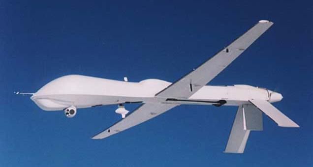
This is the weaponized version, with two Hellfire missiles under its wings, who knows, perhaps these were used to produce that crash.hole?
www.designation-systems.net...
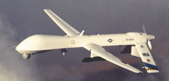
=========================================
This is the Heron, build and also used by the Israeli Air Force UAV :
en.wikipedia.org...
An earlier Heron type, this IAI Heron was put on display at the 1999 Paris Air Show :

Latest Heron type (2009) :

Operators of the Heron UAV and its derivatives :

======================================
The RQ-5 Hunter build by Israel Aircraft Industries, is also used by the US Army :
en.wikipedia.org...
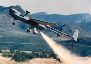

The exhaust trail you see is a booster start rocket.
======================================
This is its successor, the Alliant RQ-6 Outrider, produced 1996-1999 :
www.designation-systems.net...

The RQ-6 Outrider unmanned aerial vehicle (UAV) was designed to provide near-real-time reconnaissance, surveillance, and target acquisition information to United States Marine Corps air/ground task forces, United States Army brigades, and deployed United States Navy units that was small enough for an entire system to be contained on two High Mobility Multipurpose Wheeled Vehicles (HMMWVs) and trailer and transported on a single C-130 Hercules cargo aircraft.
The project began in 1996 and was canceled in 1999.
The "R" is the Department of Defense designation for reconnaissance; "Q" means unmanned aircraft system. The "6" refers to its being the sixth of a series of purpose-built unmanned reconnaissance aircraft systems.
Projects that are "canceled" are often taken over by Agencies like the CIA or NSA, etcetera.
General characteristics
* Payload: 60 lb (27 kg)
* Length: 118.8 in (3 m)
* Wingspan: 133.2 in (3.4 m)
* Height: 61 in (1.5 m)
* Empty weight: 300 lb (136 kg)
* Powerplant: 1× McCulloch 4318F four cylinder pusher prop, 50 hp (37.3 kw)
Performance
* Maximum speed: 110 knots (204 km/h)
* Cruise speed: 90 kt (167 km/h)
* Stall speed: 34 kt (63 km/h)
* Range: up to 200 km (108 nm)
* Endurance: 4.9 hours at 200 km, 7.2 hours at 50 km
* Service ceiling: 15,000 ft (4,572 m)
* Rate of climb: 1,600 ft/min (488 m/min)
* Operating altitude: 5,000 ft (1.5 km)
======================================
Then you also have the :
RQ-7 Shadow :
en.wikipedia.org...

And the M/RQ-1 · MQ-1C · RQ-2 · RQ-3 · RQ-4 · RQ-5 · RQ-6 · RQ-7 · MQ-8 · MQ-9 · CQ-10 · RQ-11 · (Q-12 and Q-13 not assigned) · RQ-14 · RQ-15 · RQ-16 · MQ-17 · MQ-18 · RQ-170
Look for links to these models at the bottom of the Alliant RQ-6 Outrider Wikipedia page.
======================================
This one shows the double tail-fin design :
S4 Ehécatl by Hydra Technologies from Mexico :
en.wikipedia.org...

======================================
Now when you still think that The Mirror interview of Susan McElwain is not a piece of misinformation, and you want to see if UAV's existed around 911, and how many states, armies and agencies (they don't advertise all their inventory on the Internet) were using them already, and how many had double tails with fins, like the above one, and double motors, try these lists of unmanned aerial vehicles, a.k.a. UAV's :
en.wikipedia.org...
www.designation-systems.net... (2.1 Missiles, Drones and UAVs)
www.designation-systems.net...
www.designation-systems.net...
www.designation-systems.net... (Predator B)
And weedwhacker, we already constructed +3 meter wide and long, double pusher rear propeller fitted models by using 2 Wankel motors alongside each-other at the back of a wide-body oval type fuselage, the smallest motors were about 10 cm diameter (~ 4.5 inch) and upwards. The models looked somewhat like the 1947 type jet fighter in this photo :

Interesting website, btw : www.aircrash.org...
The lubricants for early Wankel motors were the difficult part, you had to find out what gave the best endurance. Wankel motors were not known for many working hours those days, nowadays they have changed the spring mounted steel strip inlays in the three top-ends on the triangular formed piston (which function as the normally used "piston rings" on circular pistons) from hardened steel to even harder ceramic materials, and lined the cylinder with the same material (the ceramic is vaporized on a positive heated pin in a vacuum chamber and then it is condensed on the cold negative piston). I've even heard of industrial diamond vaporized and condensed on those spring mounted steel inlays.
We also build one which looked a bit like this one, the RQ-3 Darkstar :
www.designation-systems.net...
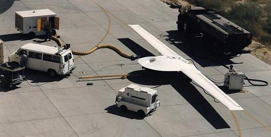
As you can see, weedwhacker, they just scaled up the model planes, that's why I indicated the far right one in my last grouped model planes picture. As you see, this disc shaped winged UAV is quite impressive in size.
And this one is probably the hidden source for many UFO encounters :
www.defense.gov...

Triangular models were of high interest in model plane circles in the sixties and seventies here.
And were and are being build, up to today. You however needed (a) big motor(s) with lots of power, since we didn't have the computerized fly by wire technique of the real ones from today.
[edit on 8/7/10 by LaBTop]
If anybody can still reach Susan McElwain, ask her if the drone, UAV or model-plane she saw looked like this one, and more importantly, if she
really ever described it as perfectly fitting an A-10 Warthog to a US reporter for The Mirror from Britain, or the US editor, Richard Wallace.
And why she, when she recalls herself the events in a recorded video, doesn't mention anything at all like that A-10 description in her 30 minutes total interview with Attero and DiMaggio I linked to earlier.
These are three videos from A-10 flying models, and one shows the underbelly while flying :
www.youtube.com...
www.youtube.com...
www.youtube.com...
By the way, if you search the UK Mirror site, for Susan McElwain, you get zero results, no articles found :
www.mirror.co.uk...
I can't find a USA based Mirror link. It does not exist.
Here's the link to The Mirror article again :
WHAT DID HAPPEN TO FLIGHT 93? RICHARD WALLACE, US Editor, examines riddle of hijacked jet as he visits crash site.
Copy/Paste this line in your web browser address bar :
web.archive.org/web/20030219235650/www.mirror.co.uk...
This one will probably go wrong again, that will be an ATS board-software problem with this link :
www.mirror.co.uk..." target="_blank" class="postlink">WHAT DID HAPPEN TO FLIGHT 93? RICHARD WALLACE, US Editor, examines riddle of hijacked jet as he visits crash site
You do realize of course, that even when it was an A-10 "Tank-killer" she saw just above her van, making a slight upwards right turn over the tree line in front of her at the junction, that it would be even more "surprising", to say the least, that such a plane appeared THERE just seconds before the crash of UAL93.
How on earth did any pilot of a military plane or UAV, knew where to look for UAL93?
[edit on 8/7/10 by LaBTop]
Originally posted by LaBTop
I am always looking at pieces of a puzzle which do not fit too well, but especially the ones which do not fit at all.
And in this case, that's Viola's explicit remark about the height at which she saw UAL93 flying over her property, and my calculation of the height that the NTSB wants us to believe it flew above her at that moment during its flight.
I calculated that it took UAL93 about 16 seconds to reach its destiny, according to the NTSB data from the FDR they got handed over by the FBI. Even when you take 10 seconds off that time, the plane was still much to high in the NTSB data list, to even come near to Viola's maple tree height of no more than 100 feet.
Ah, what the heck, it's slow today so I'll follow you down this conspiracy rat hole of yours. If you're going to be quoting eyewitnesses then you need to quote ALL of them, including peopel like Terry Butler and Homer Barron:
"A few miles north of Lambertsville, yard man Terry Butler, 40, was toiling away at Stoystown Auto Wreckers. He thought it was odd that a plane was in the area. He'd heard that all air traffic nationwide had been halted after the World Trade Center disaster about an hour earlier. "It dropped out of the clouds," too low for a commercial flight, Butler said. The plane rose slightly, trying to gain altitude, then "it just went flip to the right and then straight down." He radioed back to his office, telling coworkers Homer Barron, 49, and Jeff Phillips, 30, what he had seen. "I told them a plane crashed. At first they didn't believe it, because you know, we do joke around. Then Barron saw smoke and called 911."
Eyewitness accounts of the Shanksville crash
So if I understand you correctly, UA93 (As per Terry Butler) did crash there and yes there was a corporate falcon jet flying over the area, but in addition to this there was ANOTHER passenger jet shaped craft also flying upside down at a lower altitude which crashed (as per Viola Saylor) at the same vicinity as UA93, and in addition to this there was an ADDITIONAL craft, small (and therefure unpiloted) plane flying only feet above the ground which ALSO crashed in the same vicinity as UA93. This had to have been an additional craft becuase they describe two entirely different sized and designs.
So your take is that four planes and one unmanned drone were all out in the middle of nowhere and all at the exact same point in time, two of them were flying upside down and three of them crashed in the exact same location almost simultaneously. Do I genuinely understand you correctly?
I don't need to tell you this sounds rather idiotic, do I? I'm sorry, but the fact that Saylor and McElwain misjudged the height at which the craft they say flying explains everything more clearly than this secret gov't air armada that spontaneously showed up and crashed at the same location. You're being so much in love with these conspiracy stories that you can't bring yourself to accept that possibility is immaterial.
"As soon as we looked up, we saw a midsized jet flying low and fast," Decker said. "It appeared to make a loop or part of a circle, and then it turned fast and headed out. " Decker and Chaney described the plane as a Lear-jet type, with engines mounted near the tail and painted white with no identifying markings.
Whish fits both the description and the timing of the Falcon jet. We are therefore in agreement this account is accurate..but it does nothign to help your conspiracy stories any.
There is no conclusive evidence that she ever described that drone as an A-10, in my opinion, since she certainly had enough time in the video interview from Ettaro and DiMaggio, to come up herself with such a perfect description for the viewer of her interview, but she didn't.
You are the one who's attempting to embellish the events of the day to make it look like some sinister conspiracy is afoot, not me, so I am in full agreement that it wasn't an A-10 warthog that she had seen. There is no argument there.
Those two guys, Dennis Decker and Rick Chaney could have seen the Fairchild Falcon 20 business jet, but so soon after the UAL93 crash, it does not fit the time line description of the third plane seen by Viola Saylor, since she saw it for the first time, 5 to 10 minutes after the UAL93 crash, coming at high altitude (thus not low and fast) from the north, just after the second bigger white plane she saw coming from the south at medium high altitude, with the two eyeballs on top and swept-back wings, a perfect description of a 747 E-4B Doomsday plane, white, bigger than a 757 with two domes on top.
Good grief, so now you're saying there was a SIXTH plane?
reply to post by LaBTop
THANK YOU!!!
For those videos....I love to see one of my hobbies represented so well!!!
RADIO CONTROL airplanes is a serious hobby, and not for the faint of heart (or weak pocketbook, either).
BUT....how, exactly, is this pertaining to 9/11???
Are you suggesting that Ms. Viola Sayler saw someone's R/C (and very expensive) model of an A-10???
Going down the rabbit hole, indeed....Alice?? Are you there????
So skeptics,
What was that wingless "military-looking" rivet-less aircraft doing coming from the opposite direction that skimmed over Susan's van seconds before the alleged UA93 crash?
What was that wingless "military-looking" rivet-less aircraft doing coming from the opposite direction that skimmed over Susan's van seconds before the alleged UA93 crash?
Originally posted by ATH911
So skeptics,
What was that wingless "military-looking" rivet-less aircraft doing coming from the opposite direction that skimmed over Susan's van seconds before the alleged UA93 crash?
You forgot - it was completely silent as well! Remember - she ducked down in her van in order to avoid decapitation and, of course, like anyone else facing a beheading, she turned off the radio!
Anyway, I have to agree with your friend labtop - obviously just a local out persuing his hobby - remote control model airplanes!
new topics
-
Supreme Court Oral Arguments 4.25.2024 - Are PRESIDENTS IMMUNE From Later Being Prosecuted.
Above Politics: 59 minutes ago -
Krystalnacht on today's most elite Universities?
Social Issues and Civil Unrest: 1 hours ago -
Chris Christie Wishes Death Upon Trump and Ramaswamy
Politicians & People: 1 hours ago -
University of Texas Instantly Shuts Down Anti Israel Protests
Education and Media: 3 hours ago -
Any one suspicious of fever promotions events, major investor Goldman Sachs card only.
The Gray Area: 5 hours ago -
God's Righteousness is Greater than Our Wrath
Religion, Faith, And Theology: 10 hours ago
top topics
-
VP's Secret Service agent brawls with other agents at Andrews
Mainstream News: 14 hours ago, 11 flags -
Nearly 70% Of Americans Want Talks To End War In Ukraine
Political Issues: 15 hours ago, 6 flags -
Sunak spinning the sickness figures
Other Current Events: 15 hours ago, 5 flags -
Electrical tricks for saving money
Education and Media: 13 hours ago, 4 flags -
Late Night with the Devil - a really good unusual modern horror film.
Movies: 17 hours ago, 3 flags -
Krystalnacht on today's most elite Universities?
Social Issues and Civil Unrest: 1 hours ago, 3 flags -
Supreme Court Oral Arguments 4.25.2024 - Are PRESIDENTS IMMUNE From Later Being Prosecuted.
Above Politics: 59 minutes ago, 3 flags -
Any one suspicious of fever promotions events, major investor Goldman Sachs card only.
The Gray Area: 5 hours ago, 2 flags -
University of Texas Instantly Shuts Down Anti Israel Protests
Education and Media: 3 hours ago, 2 flags -
Chris Christie Wishes Death Upon Trump and Ramaswamy
Politicians & People: 1 hours ago, 1 flags
active topics
-
University of Texas Instantly Shuts Down Anti Israel Protests
Education and Media • 75 • : CriticalStinker -
Nearly 70% Of Americans Want Talks To End War In Ukraine
Political Issues • 72 • : andy06shake -
Chris Christie Wishes Death Upon Trump and Ramaswamy
Politicians & People • 6 • : mysterioustranger -
"We're All Hamas" Heard at Columbia University Protests
Social Issues and Civil Unrest • 282 • : 5thHead -
British TV Presenter Refuses To Use Guest's Preferred Pronouns
Education and Media • 152 • : PorkChop96 -
Candidate TRUMP Now Has Crazy Judge JUAN MERCHAN After Him - The Stormy Daniels Hush-Money Case.
Political Conspiracies • 745 • : network dude -
President BIDEN Vows to Make Americans Pay More Federal Taxes in 2025 - Political Suicide.
2024 Elections • 141 • : Euronymous2625 -
-@TH3WH17ERABB17- -Q- ---TIME TO SHOW THE WORLD--- -Part- --44--
Dissecting Disinformation • 664 • : 777Vader -
Hate makes for strange bedfellows
US Political Madness • 46 • : network dude -
The Reality of the Laser
Military Projects • 48 • : 5thHead