It looks like you're using an Ad Blocker.
Please white-list or disable AboveTopSecret.com in your ad-blocking tool.
Thank you.
Some features of ATS will be disabled while you continue to use an ad-blocker.

So what exactly is this?
page: 10
share:
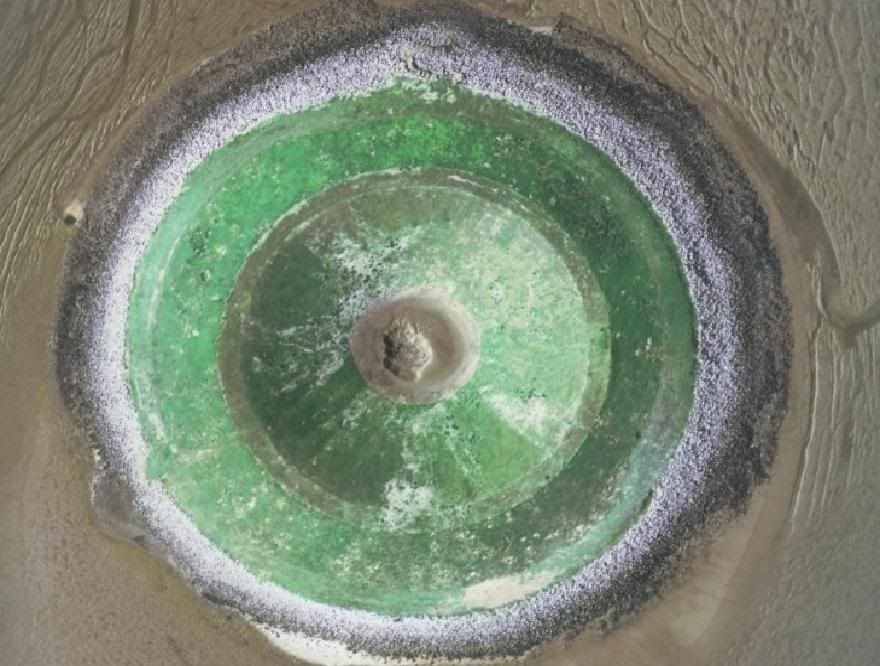
So I was just looking around in Google Earth, when I find something.... weird. I don't know what it is, its perfectly circular and nature doesn't
do perfectly circular. Anyway, here it is:
Coordinates 52°50'29.99"N, 0°14'35.34"E
So, any thoughts? Things to note are that according to Google earth's altitude data, there is only about 8 metres ASL prominence on that.. thing. Also, it measures it to be 200m across, with the middle bit 45 across. Also, to back up the altitude data there is almost no shadows on it.
Now, I know what you're thinking. It looks to be a very small Stratovolcano almost, doesn't it. Now, that is a) impossible for the area (no earthquake activity, ever pretty much), b) far too uniform to be natural (well, look at Rainier, or Kilauea, or heck, anything natural), c) no flows (well there aren't), d)no erosion on it (well, almost).
It's on the Ordnance Survey maps as well, but only at the 1:50,000 scale, where it only appears as a perfect circle. It doesn't appear on the more detailed 1:25,000 scale maps. So I am really rather confused about this.
The only similarly shaped things to this that I've found on the satellite images are the nuke test craters in Nevada. I could almost say this thing looks manmade.
Maybe I should email the BGS or OS people. They might know.
Edit, looking closer at the shadows makes it look like just a circular embankment with the middle the same mud as surrounds it. Interesting. that definitely makes it seem man made, but who'd be crazy enough to build an earthen ring on a tidal sandbank?
[edit on 17-12-2008 by apex]
[edit on 17-12-2008 by apex]
Wow, great find. I agree that the green embankment looks man made. In geology it is rare to find a perfect circle and there are no large ones. I am at
a loss. Flourite mine? Malchite? It could be the glass made by a nuclear explosion, I forgot the name. I will have to see what is near it.
One thing near it (about 3 km west) is a large area which happens to be a military training area, complete with a beached ship for target practice by
planes. Other than that, not much is nearby. Though there is another thing to the east a little way which also appears to impossibly jut out of the
sea, which is rectangular. One idea I have would be to say it could be a sea defence from WW2, there are pillboxes all over the place on the nearby
coastline. Other than that, it would only be wild uneducated guesses.
Hi:
I looked on "Wundermap" ,a Google map off shoot, and it appears that the area in question is submerged in water part of the time (Tidal?).
If you click on the "Map" version, it shows the area to be underwater, but the picture obviously is not. Hope this helps somewhat.
I looked on "Wundermap" ,a Google map off shoot, and it appears that the area in question is submerged in water part of the time (Tidal?).
If you click on the "Map" version, it shows the area to be underwater, but the picture obviously is not. Hope this helps somewhat.
reply to post by Sliick
Thanks, I was about to call King's Lynn. I wonder why the foundation is so green?
Thanks, I was about to call King's Lynn. I wonder why the foundation is so green?
reply to post by Sliick
Nice, but can't help but desire a reference for that. interesting though, quite an engineering feat to make something that size on a tidal area.
Nice, but can't help but desire a reference for that. interesting though, quite an engineering feat to make something that size on a tidal area.
reply to post by apex
A green stereo speaker.
actually, a crater filled with a lake of heavy copper content is my second guess.
A green stereo speaker.
actually, a crater filled with a lake of heavy copper content is my second guess.
is this near Arizona SE ? looks like an old copper mine, from around the Mesa, Pheonix area........
new topics
-
Las Vegas UFO Spotting Teen Traumatized by Demon Creature in Backyard
Aliens and UFOs: 1 hours ago -
2024 Pigeon Forge Rod Run - On the Strip (Video made for you)
Automotive Discussion: 1 hours ago -
Gaza Terrorists Attack US Humanitarian Pier During Construction
Middle East Issues: 2 hours ago -
The functionality of boldening and italics is clunky and no post char limit warning?
ATS Freshman's Forum: 3 hours ago -
Meadows, Giuliani Among 11 Indicted in Arizona in Latest 2020 Election Subversion Case
Mainstream News: 4 hours ago -
Massachusetts Drag Queen Leads Young Kids in Free Palestine Chant
Social Issues and Civil Unrest: 4 hours ago -
Weinstein's conviction overturned
Mainstream News: 5 hours ago -
Supreme Court Oral Arguments 4.25.2024 - Are PRESIDENTS IMMUNE From Later Being Prosecuted.
Above Politics: 7 hours ago -
Krystalnacht on today's most elite Universities?
Social Issues and Civil Unrest: 7 hours ago -
Chris Christie Wishes Death Upon Trump and Ramaswamy
Politicians & People: 7 hours ago
top topics
-
Krystalnacht on today's most elite Universities?
Social Issues and Civil Unrest: 7 hours ago, 9 flags -
Weinstein's conviction overturned
Mainstream News: 5 hours ago, 6 flags -
University of Texas Instantly Shuts Down Anti Israel Protests
Education and Media: 9 hours ago, 6 flags -
Supreme Court Oral Arguments 4.25.2024 - Are PRESIDENTS IMMUNE From Later Being Prosecuted.
Above Politics: 7 hours ago, 5 flags -
Massachusetts Drag Queen Leads Young Kids in Free Palestine Chant
Social Issues and Civil Unrest: 4 hours ago, 4 flags -
Meadows, Giuliani Among 11 Indicted in Arizona in Latest 2020 Election Subversion Case
Mainstream News: 4 hours ago, 4 flags -
Chris Christie Wishes Death Upon Trump and Ramaswamy
Politicians & People: 7 hours ago, 2 flags -
Any one suspicious of fever promotions events, major investor Goldman Sachs card only.
The Gray Area: 11 hours ago, 2 flags -
Gaza Terrorists Attack US Humanitarian Pier During Construction
Middle East Issues: 2 hours ago, 2 flags -
2024 Pigeon Forge Rod Run - On the Strip (Video made for you)
Automotive Discussion: 1 hours ago, 1 flags
active topics
-
Fossils in Greece Suggest Human Ancestors Evolved in Europe, Not Africa
Origins and Creationism • 86 • : whereislogic -
The functionality of boldening and italics is clunky and no post char limit warning?
ATS Freshman's Forum • 12 • : grey580 -
Krystalnacht on today's most elite Universities?
Social Issues and Civil Unrest • 4 • : marg6043 -
Nearly 70% Of Americans Want Talks To End War In Ukraine
Political Issues • 90 • : Consvoli -
Candidate TRUMP Now Has Crazy Judge JUAN MERCHAN After Him - The Stormy Daniels Hush-Money Case.
Political Conspiracies • 789 • : WeMustCare -
University of Texas Instantly Shuts Down Anti Israel Protests
Education and Media • 193 • : cherokeetroy -
2024 Pigeon Forge Rod Run - On the Strip (Video made for you)
Automotive Discussion • 7 • : TheInvisibleRedneck -
Supreme Court Oral Arguments 4.25.2024 - Are PRESIDENTS IMMUNE From Later Being Prosecuted.
Above Politics • 63 • : Annee -
Las Vegas UFO Spotting Teen Traumatized by Demon Creature in Backyard
Aliens and UFOs • 5 • : FlyersFan -
Thousands Of Young Ukrainian Men Trying To Flee The Country To Avoid Conscription And The War
Other Current Events • 139 • : Consvoli
0