It looks like you're using an Ad Blocker.
Please white-list or disable AboveTopSecret.com in your ad-blocking tool.
Thank you.
Some features of ATS will be disabled while you continue to use an ad-blocker.

Solid clear as day footage of structures on Mars!
page: 10
share:
sorry about the bold caps heading but i am so excited.. no more scanning for `shadows or mini rocks or having to adjust contrasts... here it is clear
as the nose on your face..............
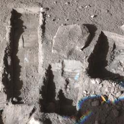
look at the picture
on the right hand side you can see slightly buried walls and structures identical to roman and ancient ruins on earth......... looks like they have been caved in or lead underground
i cant believe nasa let this one get through.. here it is UNDENIABLE PROOF OF PAST CIVILISATION ON MARS!
[edit on 10-11-2008 by weneedtoknow]
Mod Edit: Removed all caps title
[edit on 10-11-2008 by Gemwolf]
this'd better be dood.....clicks link....
sigh.this looks like where that rover was doing a bit of digging.
sigh.this looks like where that rover was doing a bit of digging.
close up of the floor it looks to me.
but if you back up into that directory on the server, there are tons of other interesting images to look at.
photojournal.jpl.nasa.gov...
but if you back up into that directory on the server, there are tons of other interesting images to look at.
photojournal.jpl.nasa.gov...
jup , it seems those are pictures of the "after scoop shot" they usually take after they digged something up . My guess is that the look if there is
a reason to dig further ....
PIA11382
Original Caption Released with Image:
Image Credit:
NASA/JPL-Caltech//University of Arizona/Texas A&M University
____________________________________________________
PIA11383
Original Caption Released with Image:
Image Credit:
NASA/JPL-Caltech//University of Arizona/Texas A&M University
Original Caption Released with Image:
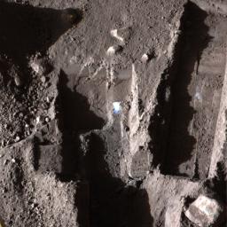
The Surface Stereo Imager on NASA's Phoenix Mars Lander took this false color image on Oct. 21, 2008, during the 145th Martian day, or sol, since landing. The white areas seen in these trenches are part of an ice layer beneath the soil.
The trench on the upper left, called "Upper Cupboard," is about 60 centimeters (24 inches) long and 3 centimeters (1 inch) deep. The trench in the middle, called "Ice Man," is about 30 centimeters (12 inches) long and 3 centimeters (1 inch) deep. The trench on the right, called "La Mancha," is about 31 centimeters (12 inches) and 5 centimeters (2 inches) deep.
Image Credit:
NASA/JPL-Caltech//University of Arizona/Texas A&M University
____________________________________________________
PIA11383
Original Caption Released with Image:
The Surface Stereo Imager on NASA's Phoenix Mars Lander took this false color image on Oct. 21, 2008, during the 145th Martian day, or sol, since landing. The bluish-white areas seen in these trenches are part of an ice layer beneath the soil.
The trench on the upper left, called "Dodo-Goldilocks," is about 38 centimeters (15 inches) long and 4 centimeters (1.5 inches) deep. The trench on the right, called "Upper Cupboard," is about 60 centimeters (24 inches) long and 3 centimeters (1 inch) deep. The trench in the lower middle is called "Stone Soup."
Image Credit:
NASA/JPL-Caltech//University of Arizona/Texas A&M University
reply to post by internos
but that looks like an archaeological dig
you can tell those are structures or remains
not dirt and ice!
Mod edit: Removed big quote.
Big Quote – Please Review This Link.
[edit on 10-11-2008 by Gemwolf]
but that looks like an archaeological dig
you can tell those are structures or remains
not dirt and ice!
Mod edit: Removed big quote.
Big Quote – Please Review This Link.
[edit on 10-11-2008 by Gemwolf]
Sorry OP the guys are correct in what they are saying Good try tho for keeping a eye open
Originally posted by weneedtoknow
reply to post by internos
but that looks like an archaeological dig
you can tell those are structures or remains
not dirt and ice!
weneedtoknow, maybe you think that these images were taken by some orbiter, but they were taken by Phoenix, a lander. What we see is close, very close, extremely close to the camera: i post another example of the marks, it's the second dig: I post also some more informations regarding Phoenix lander's work area.
Second Dig and Dump Test


Image Credit: NASA/JPL-Caltech/University of Arizona
Full res image:
www.nasa.gov...
The Robotic Arm took a second scoop full of soil and revealed whitish material at the bottom of the dig area informally called the "Knave of Hearts". The Science Team is debating whether this is a salt layer or the top of an ice table. Image was taken by the Surface Stereo Imager on the ninth day of the Mars mission, or Sol 9, (June 3, 2008) aboard the NASA Phoenix Mars Lander.
www.nasa.gov...
Basically, those marks were left by this:

The Phoenix Robotic Arm, during testing at JPL.
Engineers Bob Bonitz and Matt Robinson are shown in the background, in protective suits.
www-robotics.jpl.nasa.gov...

Image credit: NASA/JPL/UA/Lockheed Martin
Trench Visualization


Image Credit: NASA/JPL-Caltech/University of Arizona/Texas A&M University/NASA Ames
Full res image:
www.nasa.gov...
This image shows oblique views of NASA's Phoenix Mars Lander's trench visualized using the NASA Ames Viz software package that allows interactive movement around terrain and measurement of features. The Surface Stereo Imager images are used to create a digital elevation model of the terrain. The trench is 1.5 inches deep. The top image was taken on the seventh Martian day of the mission, or Sol 7 (June 1, 2008). The bottom image was taken on the ninth Martian day of the mission, or Sol 9 (June 3, 2008).
www.nasa.gov...
Phoenix Lander Work Area

Image Credit: NASA Ames
Full res image:
www.nasa.gov...
This image shows NASA's Phoenix Mars Lander Robotic Arm work area with an overlay. The pink area is available for digging, the green area is reserved for placing the Thermal and Electrical Conductivity Probe (TECP) instrument. Soil can be dumped in the violet area.Images were displayed using NASA Ames "Viz" visualization software.
www.nasa.gov...
Map of Phoenix Digging Area

Image Credit: NASA Ames
Full res image:
www.nasa.gov...
This image shows where NASA's Phoenix Mars Lander's Robotic Arm scoop has started digging, and the next areas planned for digging. The majority of the area to the right of the current trench is being preserved for future digging.
I hope this helps
reply to post by internos
good job internos!
i think just about anyone looking knew this was a closeup but you provided info supporting that much better than i could have done.
my first thought at seeing the picture was "that looks like my driveway"
good job internos!
i think just about anyone looking knew this was a closeup but you provided info supporting that much better than i could have done.
my first thought at seeing the picture was "that looks like my driveway"
new topics
-
Former NYT Reporter Attacks Scientists For Misleading Him Over COVID Lab-Leak Theory
Education and Media: 53 minutes ago -
Why did Phizer team with nanobot maker
Medical Issues & Conspiracies: 1 hours ago -
Pro Hamas protesters at Columbia claim hit with chemical spray
World War Three: 1 hours ago -
Elites disapearing
Political Conspiracies: 3 hours ago -
A Personal Cigar UFO/UAP Video footage I have held onto and will release it here and now.
Aliens and UFOs: 3 hours ago -
Go Woke, Go Broke--Forbes Confirms Disney Has Lost Money On Star Wars
Movies: 5 hours ago -
Freddie Mercury
Paranormal Studies: 6 hours ago -
Nirvana - Immigrant Song
Music: 10 hours ago -
British TV Presenter Refuses To Use Guest's Preferred Pronouns
Education and Media: 11 hours ago
top topics
-
British TV Presenter Refuses To Use Guest's Preferred Pronouns
Education and Media: 11 hours ago, 16 flags -
Go Woke, Go Broke--Forbes Confirms Disney Has Lost Money On Star Wars
Movies: 5 hours ago, 12 flags -
Pro Hamas protesters at Columbia claim hit with chemical spray
World War Three: 1 hours ago, 9 flags -
Trump To Hold Dinner with President of Poland At Trump Tower Tonight
2024 Elections: 14 hours ago, 8 flags -
Tucker Carlson interviews Christian pastor from Bethlehem.
Middle East Issues: 13 hours ago, 7 flags -
Elites disapearing
Political Conspiracies: 3 hours ago, 7 flags -
A family from Kansas with six children moved to the Moscow region
Other Current Events: 17 hours ago, 6 flags -
Freddie Mercury
Paranormal Studies: 6 hours ago, 6 flags -
A Personal Cigar UFO/UAP Video footage I have held onto and will release it here and now.
Aliens and UFOs: 3 hours ago, 5 flags -
Nirvana - Immigrant Song
Music: 10 hours ago, 4 flags
active topics
-
Trump To Hold Dinner with President of Poland At Trump Tower Tonight
2024 Elections • 36 • : ImagoDei -
British TV Presenter Refuses To Use Guest's Preferred Pronouns
Education and Media • 46 • : Unknownparadox -
Elites disapearing
Political Conspiracies • 14 • : AwakeNotWoke -
Freddie Mercury
Paranormal Studies • 1 • : AwakeNotWoke -
Why did Phizer team with nanobot maker
Medical Issues & Conspiracies • 1 • : AwakeNotWoke -
Pro Hamas protesters at Columbia claim hit with chemical spray
World War Three • 6 • : DBCowboy -
Former NYT Reporter Attacks Scientists For Misleading Him Over COVID Lab-Leak Theory
Education and Media • 1 • : Dandandat3 -
Gold and silver prices....woo hoo
History • 75 • : SchrodingersRat -
-@TH3WH17ERABB17- -Q- ---TIME TO SHOW THE WORLD--- -Part- --44--
Dissecting Disinformation • 512 • : cherokeetroy -
A Personal Cigar UFO/UAP Video footage I have held onto and will release it here and now.
Aliens and UFOs • 9 • : Ophiuchus1
0