It looks like you're using an Ad Blocker.
Please white-list or disable AboveTopSecret.com in your ad-blocking tool.
Thank you.
Some features of ATS will be disabled while you continue to use an ad-blocker.

G Force calculations prove official Pentagon attack flight path impossible
page: 9share:
Listen, you guys aren't school children, and the forum moderators here are not the "teachers" because if it continues one of the mod's will come
on, so for the love of God can you both follow the rules set forth here and free yourselves of the mudslinging and stick to the facts. Its an
interesting topic and we have had enough people either 'attacking' or 'derailing'.
[edit on 19-9-2008 by talisman]
[edit on 19-9-2008 by talisman]
SlightlyAbovePar,
We address almost every one of your questions in our full presentation (edit to add: Note the very first quote in the opening title page for a hint). Unfortunately, we cannot offer the full presentation free to the public yet in order to recoup costs and to raise funds for exactly what you reference. Lawyers cost alot of money today...
With that said, here is a quote from Lt Col Jeff Latas (USAF ret) after reviewing our film...
Jeff Latas Credentials/Experience
-Over 20 years in the USAF
--USAF Accident investigation Board President
--Flew the F-111, T38, and F-15E
--Combat experience in the F-15E includes Desert Storm and four tours of duty in Northern and Southern Watch
--Weapons Requirements Officer, USAF HQ, Pentagon
--Standard and Evaluations Flight Examiner, Command level
-Currently Captain for JetBlue Airways
Eventually we will offer our new film for free on google as we have every other film we have produced albeit at a much lower quality (not much we can do about that).
Regards,
Rob
noted above
[edit on 19-9-2008 by johndoex]
We address almost every one of your questions in our full presentation (edit to add: Note the very first quote in the opening title page for a hint). Unfortunately, we cannot offer the full presentation free to the public yet in order to recoup costs and to raise funds for exactly what you reference. Lawyers cost alot of money today...
With that said, here is a quote from Lt Col Jeff Latas (USAF ret) after reviewing our film...
Very good!
This is very factual and deserves much attention. You did a good job on presenting your case. While watching, I put myself in a court room and listened as if this were a court case and your argument was very compelling.
Jeff
pilotsfor911truth.org...
Jeff Latas Credentials/Experience
-Over 20 years in the USAF
--USAF Accident investigation Board President
--Flew the F-111, T38, and F-15E
--Combat experience in the F-15E includes Desert Storm and four tours of duty in Northern and Southern Watch
--Weapons Requirements Officer, USAF HQ, Pentagon
--Standard and Evaluations Flight Examiner, Command level
-Currently Captain for JetBlue Airways
Eventually we will offer our new film for free on google as we have every other film we have produced albeit at a much lower quality (not much we can do about that).
Regards,
Rob
noted above
[edit on 19-9-2008 by johndoex]
Originally posted by talisman
Listen, you guys aren't school children, and the forum moderators here are not the "teachers" because if it continues one of the mod's will come on, so for the love of God can you both follow the rules set forth here and free yourselves of the mudslinging and stick to the facts. Its an interesting topic and we have had enough people either 'attacking' or 'derailing'.
Thank you. I couldn't have said it better my self.
Stick to the topic everyone. Any further off topic remarks or attempts at derailing the discussion will be dealt with.
Originally posted by Craig Ranke CIT
As someone who defends the government YOU are the one who has to answer to the fraudulent NTSB data.
First of all it's not fraudulent. You are the one who continues to indicate you have ALL of the data and I keep telling you that you don't. If it's fraudulent then you can't use it for proving anything simply because YOU consider it fraudulent. You are defending the FDR (NTSB Data) in an attempt to prove it's wrong and yet when I agree with you that it's wrong (missing data) you argue that it's not. Too funny! I'm splitting my sides laughing now.
Originally posted by Craig Ranke CIT
We have already proven the data fraudulent which in turn proves 9/11 was an inside job.
No you haven't. All you've proven is that you can take an object and maliciously use it to prove a delusion. You, in fact, are the "InSiDe Jeob".
Originally posted by Craig Ranke CIT
You simply ignore the evidence
Cognitive Dissonance and transference at it's finest.
reply to post by Reheat
I have to ay, well done on your analysis. I did read your NoC report, and it does make a whole lot more sense then what the OP is saying. I like how you point out the fact that the conspiracy theorists twisted the "pointing" detail, and lied about it. Its simple little twists and turns that the the "truthers" depend on to continue their lies unabated. To a layman, who doesnt no much about these things, he would believe the OP. To someone is more educated and does some research, your explanation is the correct one. But again, nice catch on the "pointing" twist. Who knows how many such little deceptions were undertaken by the "truthers"?
I have to ay, well done on your analysis. I did read your NoC report, and it does make a whole lot more sense then what the OP is saying. I like how you point out the fact that the conspiracy theorists twisted the "pointing" detail, and lied about it. Its simple little twists and turns that the the "truthers" depend on to continue their lies unabated. To a layman, who doesnt no much about these things, he would believe the OP. To someone is more educated and does some research, your explanation is the correct one. But again, nice catch on the "pointing" twist. Who knows how many such little deceptions were undertaken by the "truthers"?
I would like to ask a simple question. How FDR position data are obtained? I mean not where they are published, but what is the physical source of
this information? Inertial Navigation System, GPS or what? And what accuracy it has? I assume that NTSB just published what they got. But how can
you be sure the data are accurate? Same applies to altitude data. Does it come from barometric altimeter? If so, was it corrected for barometric
bressure?
[edit on 19-9-2008 by syeager9]
[edit on 19-9-2008 by syeager9]
reply to post by johndoex
NOTE TO SELF:
DO NOT EVER fly on a jetblue plane.
Mod Edit: Big Quote – Please Review This Link.
[edit on 9/19/2008 by Hal9000]
NOTE TO SELF:
DO NOT EVER fly on a jetblue plane.
Mod Edit: Big Quote – Please Review This Link.
[edit on 9/19/2008 by Hal9000]
Originally posted by johndoex
Originally posted by Reheat
Hay, Cap'n Bob
One of my friends send me this graphic and requested that I ask you explain the data points shown. Would you be so kind as it accommodate him? Thanks in advance.
Edit: I see the graphic is too wide for the display here, so I've posted a link to it:
i286.photobucket.com...
[edit on 19-9-2008 by Reheat]
Your "friend"? What.. did Beachnut get banned here? Wouldnt be surprised...
Anyway...
video.google.com...
Also, you may want to tell Beachy to quote the whole AIM reference before he looks even more a fool and intellectually dishonest. He has a bunch of jetBlue pilots in stitches over here with his DME claims..lol. Especially those of us who shoot LOC/DME, arcs.. step downs, crossing restrictions... you get the idea.... Its almost as good as his "FDR loses power at 0.2 G" BS... lmao.
I'm not going to watch all of your crappy utube videos, but I watched enough to see how you've dodged the Radar Return from ADW (Reagan National TRACON) which shows AA77 well short of he VDOT antenna at 13:37:47, two full seconds after you base your recent cartoon on 13:37:45 impact time. That shows there is data missing. Your use of 1.5 DME in the video you referenced show there is missing data. Did AA77 strike the Pentagon from 1.5 DME to the Southwest? Apparently you believe in some kind of Starwars projection that allows the aircraft to not be able to descend within parameters to strike the building from 1.5 DME away. Of course, it can't and that simply proves missing data. You have PROVEN there is missing data with your own material, yet you pretend there is no missing data to make a cartoon. That is one of the most ludicrous parts of your entire fantasy.
In addition, all of the witnesses who saw it strike the building prove there is missing data. The physical evidence (all of it) prove there is missing data.
You prove missing data with your own material, then you pretend there is no missing data. Yet you expect someone to take you seriously?
Originally posted by johndoex
SlightlyAbovePar,
We address almost every one of your questions in our full presentation (edit to add: Note the very first quote in the opening title page for a hint). Unfortunately, we cannot offer the full presentation free to the public yet in order to recoup costs and to raise funds for exactly what you reference. Lawyers cost alot of money today...
but you refuse to address them here.. here is where the discussion is.. if you will not answer the questions raised here then all it amounts to is pimping a video.. nothing wrong with charging $ for the work you have done.. but its very disingenuous to avoid the questions here.. SAP has posted these questions many times(the same list).. are you uncomfortable discussing this OUTSIDE of your CONTROLLED presentation?
just asking.. because it seems like you guys will avoid these details at any cost.. is the answering of questions here, somehow detrimental to the overall presentation?
sometimes things are better explained through a concise presentation, which you have.. but since this discussion is taking place on a public forum, it seems only reasonable to ask for the questions to be answered here..
and realistically the back and forth regarding the math is going nowhere.. you have half a theory.. without some idea where the supposed flyover plane went.. we are left with half a theory.. which I might add is in serious need of evidence.. not one shred of PHYSICAL evidence lines up with your theory.. only the witnesses.. of which, contradict many other witnesses flight paths.. and further, contradict themselves..
here is a photo shortly after the (choose one) explosion/impact/globalhawk/missle strike.. note the extent of the fires.. and another one up close.. the evidence is consistent with a rather large commercial passenger jet impacting the first floor of the Pentagon.. you can even see where the right engine impacted.. and the small pieces found in other pics) most likely match that of a RB211 Rolls Royce engine that the 757's used.

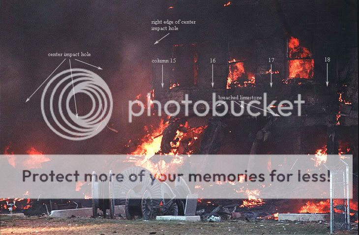
originally found here.. click on link to see the full photos these are chopped off on the right side.. too big I guess..
www.oilempire.us...
Mod edit: fixed quote
[edit on 9/19/2008 by Hal9000]
"Pffft and CIT, I'm sure your mothers are very proud of you. "
I was pretty amazed by the blatant name calling and baiting your crafty tongue can produce. One of my buddies owns a Used Car Lot, you would do well there.
Reading the above statement, I had flash backs to yelling on the playground those same statements, when I was 12.
Good day to you Sir, those that throw stones, would do wise not to live in glass homes. =)

Hi pccat,
First, let me suggest you fix your quote tags as your reply may confuse the readers who arent familair with forum tags.
Next, if i can be so bold...
I could not care less if your questions are answered here among the few. Our hits have never been higher and those who are asking such questions sans further research already have their opinion established. Its a moot point and a waste of time to address them here and now. But i assure you, those asking, will continue to look like a fool to those who have actually seen our work... now, or when its streaming on our front page as is PBB2.
So, continue to think what you will from behind your screen. We'll continue to put our name, faces and professional reputations on our work as we close the walls in on people like you and "SlightlyAbovePar". Meanwhile, the masses are getting answers from real professionals and experts with verifyable credentials...
I know this doesnt help you much.. but.. i really dont care...
Rob
PS, i'll add this caveat (as i have offered this to other "pseudo-skeptics). If SlightlyAbovePar emails us his address, we will send him a free DVD. On one condition, that he copies our DVD and ships it to anyone who asks on his dime... deal? Would you order one if it were free pccat?

Mod Note: No more posting personal information.
[edit on 9/19/2008 by Hal9000]
Originally posted by syeager9
I would like to ask a simple question. How FDR position data are obtained? I mean not where they are published, but what is the physical source of this information? Inertial Navigation System, GPS or what? And what accuracy it has? I assume that NTSB just published what they got. But how can you be sure the data are accurate?
You've just identified the major problem with this delusion stated by the OP. They don't know the precise longitudinal position at all. They also DO NOT know exactly how AA77 flew past the VDOT tower. For example, did it pass over or if it did how far up the tower it was and to which side. There is no way to determine that exact position at that time.
The NTSB uses all resources available to determine a position in an accident investigation which can take up to a year or more. This was NOT AN ACCIDENT INVESTIGATION as it was not an accident. The NTSB did a simple Flight Path Study as requested by the FBI. What we have IS NOT the normal NTSB product for an Accident Investigation. It is an abbreviated study done within a fairly short period of time.
The most accurate way to determine a position from the FDR would be GPS. It is very accurate to within about 10 meters under normal conditions. Unfortunately, AA77 did not have a GPS installed. They had an INS which is not very accurate in this application. It is updated with VOR/DME to an accuracy of approximately 2000'-4000'. Don't be confused between Airline INS application and military aircraft who also use INS. The military INS's are updated using precision Radar or Precision Laser Designators or visual IR viewers. So, while the military application is very accurate the Airline application is not. However, it is accurate enough for flight use in addition to traditional VOR/DME.
For AA77's position the NTSB used INS and heading and some early Radar Data to determine a general flight path. Physical evidence along the flight path also helped determine the aircraft's path, as well. The NTSB Flight Path Study does not include enough detail to determine any other methods which might have been used.
The major problem with the OP's premise is that they DO NOT know the position with the accuracy required to make the conclusions drawn. They base most of this crap on the published impact time which is of unknown precision. There is data missing from the FDR which has been proven by the OP's own material and other material. For example, the recently released Reagan National Radar Records indicate the impact time used by the OP is in error by 5-6 seconds. I posted a graphic of that analysis a page or so back.
I hope I've given you a thorough enough answer. If not, ask for clarification or additional information and I'll try to help.
According to the many FDR Companies we (P4T) called (including the manufacturer of the FDR and Aircraft Accident Investigators in our organization at
pilotsfor911truth.org...), they adamantly refer to DME as the most accurate in terms of location/position. However, they also offered this
during our interview...
The anonymous "experts" such as Reheat, Beachnut.. .etc, refuse to call such companies or NTSB to verify such information and instead spend their days and nights anonymously attacking P4T and CIT from behind their screens. Beachnut and Reheat also readily admit they work for the govt.
We leave the decision up to the reader... Feel free to email us if you need phone numbers and/or companies to contact to prove Reheat and Beachnut frauds in your mind. We already know they are...
Regards
Rob
typos
[edit on 19-9-2008 by johndoex]
If you know where the airplane departed, we can truly determne where the airplane was by pure physics. We have some very sophisticated equipment. If you know where the airplane took off, we know the airplane turned left, right, up down, speed... We can precisley determine last position based purely on physics. But if you have DME, that is the most accurate...
The anonymous "experts" such as Reheat, Beachnut.. .etc, refuse to call such companies or NTSB to verify such information and instead spend their days and nights anonymously attacking P4T and CIT from behind their screens. Beachnut and Reheat also readily admit they work for the govt.
We leave the decision up to the reader... Feel free to email us if you need phone numbers and/or companies to contact to prove Reheat and Beachnut frauds in your mind. We already know they are...
Regards
Rob
typos
[edit on 19-9-2008 by johndoex]
Yes, it's quite enough. I suspected it was INS, as GPS couldn't be used as a primary method of navigation at that time. I also added question about altitude data. Can anyone know how altimeter data are obtained? If this is barometric? If so, did terrorists call ATC for settings? I guess we can exclude radar altitude data or radio altimeter, if the airplane had one.
Originally posted by Reheat
...
I hope I've given you a thorough enough answer. If not, ask for clarification or additional information and I'll try to help.
And, of course, I can understand that flight path didn't have any significance, as it was absolutely clear to everyone from the beginning that it was AA flight that slammed into Pentagon.
[edit on 19-9-2008 by syeager9]
Quick question for anyone...
Does the NTSB know inherent errors associated with INS? Or is it only "Reheat" and "Beachnut" who knows of such "errors".
If you think the NTSB knows more than "Reheat" or "Beachnut", why do you think the NTSB "impact time" on the NTSB Flight Path Study, time /speed/distance calculations differ from what admitted govt employees (albeit anonymous) "Beachnut" and "Reheat" are trying to get you to swallow?
If you think "Reheat" and "Beachnut" know more than the NTSB, why are "Beachnut" and "Reheat" and yourself allowing the NTSB/FBI to distribute "error filled data" through the FOIA to the American public?
Bottom line, there are two anonymous self proclaimed experts telling you, "Nothing to see here folks, move along", while the following people are growing in numbers saying, "Yes, pay attention..."
pilotsfor911truth.org...
patriotsquestion911.com...
The above is exactly why "Beachnut" and "Retreat" refuse to debate on air live. Because when asked the above, they will be more flustered and frustrated than you see them now...
"But you try to kill us Rob!".. will be their only reply..lol
Your mileage may vary....
[edit on 19-9-2008 by johndoex]
Originally posted by syeager9
I would like to ask a simple question. How FDR position data are obtained? I mean not where they are published, but what is the physical source of this information? Inertial Navigation System, GPS or what? And what accuracy it has? I assume that NTSB just published what they got. But how can you be sure the data are accurate? Same applies to altitude data. Does it come from barometric altimeter? If so, was it corrected for barometric bressure?
I would like to stay out of this thread as I really know little about aviation, but "they" can pin point us down to an inch just with our cell phones. Do you really believe radar, NORAD, FAA etc. are really that off? Would we be willing to step into a plane if so?
Actually it's a very small percentage of people who believe in CTs about 911. I, personally, don't know a single one. But Conspiracy Theorists are very loud on the web, like some other groups - UFO hunters, etc.
Originally posted by johndoex
"Nothing to see here folks, move along", while the following people are growing in numbers saying, "Yes, pay attention..."
Originally posted by syeager9
I guess we can exclude radar altitude data or radio altimeter, if the airplane had one.
Radar Altitude Confrims Too High
(based on "Missing Seconds" Claims from
Govt Loyalist Arguments)
pilotsfor911truth.org...
JREF - The Players
www.abovetopsecret.com...
(at one time ReTreat claimed we didnt address DME)
new topics
-
Comparing the theology of Paul and Hebrews
Religion, Faith, And Theology: 25 minutes ago -
Pentagon acknowledges secret UFO project, the Kona Blue program | Vargas Reports
Aliens and UFOs: 1 hours ago -
Boston Dynamics say Farewell to Atlas
Science & Technology: 1 hours ago -
I hate dreaming
Rant: 2 hours ago -
Man sets himself on fire outside Donald Trump trial
Mainstream News: 4 hours ago -
Biden says little kids flip him the bird all the time.
2024 Elections: 4 hours ago -
The Democrats Take Control the House - Look what happened while you were sleeping
US Political Madness: 4 hours ago -
Sheetz facing racial discrimination lawsuit for considering criminal history in hiring
Social Issues and Civil Unrest: 4 hours ago -
In an Historic First, In N Out Burger Permanently Closes a Location
Mainstream News: 6 hours ago -
MH370 Again....
Disaster Conspiracies: 7 hours ago
top topics
-
In an Historic First, In N Out Burger Permanently Closes a Location
Mainstream News: 6 hours ago, 14 flags -
The Democrats Take Control the House - Look what happened while you were sleeping
US Political Madness: 4 hours ago, 11 flags -
Thousands Of Young Ukrainian Men Trying To Flee The Country To Avoid Conscription And The War
Other Current Events: 17 hours ago, 8 flags -
A man of the people
Medical Issues & Conspiracies: 12 hours ago, 8 flags -
Man sets himself on fire outside Donald Trump trial
Mainstream News: 4 hours ago, 7 flags -
Biden says little kids flip him the bird all the time.
2024 Elections: 4 hours ago, 6 flags -
4 plans of US elites to defeat Russia
New World Order: 14 hours ago, 4 flags -
Pentagon acknowledges secret UFO project, the Kona Blue program | Vargas Reports
Aliens and UFOs: 1 hours ago, 4 flags -
Sheetz facing racial discrimination lawsuit for considering criminal history in hiring
Social Issues and Civil Unrest: 4 hours ago, 3 flags -
Are you ready for the return of Jesus Christ? Have you been cleansed by His blood?
Religion, Faith, And Theology: 9 hours ago, 3 flags
active topics
-
The Democrats Take Control the House - Look what happened while you were sleeping
US Political Madness • 40 • : ImagoDei -
Thousands Of Young Ukrainian Men Trying To Flee The Country To Avoid Conscription And The War
Other Current Events • 39 • : RickyD -
12 jurors selected in Trump criminal trial
US Political Madness • 109 • : ImagoDei -
Boston Dynamics say Farewell to Atlas
Science & Technology • 2 • : theatreboy -
The defamation of Mary Magdalene
Religion, Faith, And Theology • 15 • : Solvedit -
A man of the people
Medical Issues & Conspiracies • 9 • : tarantulabite1 -
Silent Moments --In Memory of Beloved Member TDDA
Short Stories • 47 • : Naftalin -
George Knapp AMA on DI
Area 51 and other Facilities • 28 • : theshadowknows -
Pentagon acknowledges secret UFO project, the Kona Blue program | Vargas Reports
Aliens and UFOs • 4 • : Ophiuchus1 -
Comparing the theology of Paul and Hebrews
Religion, Faith, And Theology • 0 • : DISRAELI2