It looks like you're using an Ad Blocker.
Please white-list or disable AboveTopSecret.com in your ad-blocking tool.
Thank you.
Some features of ATS will be disabled while you continue to use an ad-blocker.

hollow earth, maybe proof
page: 11
share:
came across this pritygood program
its taken a 3D image of the earth and if you look at the north pole, where one of the entrances is supposed to be located, you see a hole, have a gander, see wht you think.

[edit on 10-9-2008 by trekker]
its taken a 3D image of the earth and if you look at the north pole, where one of the entrances is supposed to be located, you see a hole, have a gander, see wht you think.
[edit on 10-9-2008 by trekker]
reply to post by trekker
What's the name of the program and where can we download it?
You're implying this was taken from space?
What's the name of the program and where can we download it?
You're implying this was taken from space?
i would assume it was taken rom space, with what sat i dont know, but the prog is called 3D world Map [Snip]
Mod Edit: Please see Terms and Conditions of Use section 2b.) HaXor. Thank you - Jak
[edit on 10/9/08 by JAK]
Mod Edit: Please see Terms and Conditions of Use section 2b.) HaXor. Thank you - Jak
[edit on 10/9/08 by JAK]
Looks like a massive triangle shaped whole, quite interesting, I don't think it is from space, it's a CGI mock up from data from satelites I think.
I consider hollow earth to be quite a possibility, although, the name is abit of a put off for most. IMO, it isn't 'hollow' like, say, a tennis
ball, but dotted, throughout with caverns, varying from the size of large continents, to rooms, latticed with tunnels and cavesystems etc. The Mantle
is nearly 3000km thick (about 1800 miles), imagine, the size of some of these possible caverns?
Good thread
EMM
Good thread
EMM
I see an exaggerated heightmap of the earth. There is no hole there, that's called the ocean floor: its lower than sealevel.
Unless you imply that mountains extend far, far beyond earths atmosphere...
[edit on 10-9-2008 by merka]
Unless you imply that mountains extend far, far beyond earths atmosphere...
[edit on 10-9-2008 by merka]
what i found interesting was the fact that this hollow area at the north pole is noticeably a lot deeper that any of the oceans, including Marianas
trench.
found out what sat it uses in the help file its called the "GTOPO30"
found out what sat it uses in the help file its called the "GTOPO30"
probably just images missing from the final rendering ... guess they deceided that it wasnt of much interest. !
sorry for the short post.
sorry for the short post.
What about the south pole? I thought Hollow earth theory was both poles? I do not need more software on my computer, so I would appreciate it if
anyone could post the south pole.
-Kdial1
-Kdial1
Originally posted by kdial1
What about the south pole? I thought Hollow earth theory was both poles? I do not need more software on my computer, so I would appreciate it if anyone could post the south pole.
-Kdial1
That is a good point, although, when the 'hole in the pole' was discovered on Saturn, it was the north pole. Now, is this because they were looking for it on Saturn, due to there findings on Earth, or is it that the South pole doesn't have a 'visible hole'? Don't know, but as I said, good point.
EMM
Originally posted by trekker
what i found interesting was the fact that this hollow area at the north pole is noticeably a lot deeper that any of the oceans, including Marianas trench.
The trench isnt in the picture...
A heightmap is rarely exact, unless you slap on so many polygons a modern supercomputer would have trouble rendering it. Each neighbouring vertice affect the other, so a thin trench would not give the impression of being as deep as a wide hole when you start exaggerating the height values.
oh.. isnt that amazing.. a big .. sorry.. not big.. a gigantic whole up there in the north ... and your the one who finds it.. .. after all.. we fly
over that area all th e time.. many times a day in fact.. but no one has ever seen that whole in the earth... it looks to be about the size of
greenland.. I wonder how the hell it got there.. kind of like walking into your home one day.. after about 30 yrs.. and you discover that there is a
kitchen in your house.. and you never saw it before.. what a shocker huh.. damnnn
He is the north pole from straight up

and someone said they'd like to see the south, here it is, as to the accuracy of the scale, i wouldn't have a clue

trekker
and someone said they'd like to see the south, here it is, as to the accuracy of the scale, i wouldn't have a clue
trekker
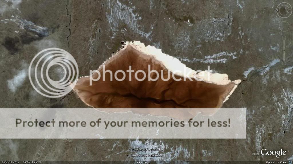
could be , but where is all the snow from your image, the hole looks the same shape. can you do another one but zoom it out a bit so i can see the
land mass
awesome....which way is up ?...down is up,..up is down.....1,800 miles deep of mantel is an enormous area to find hollow
places.........Anything is possible.......It could solve some of the problems pertaining to where UFO's come from......or not...This
planet has much to be discovered..And I believe many of it's secrets have been suppressed.......
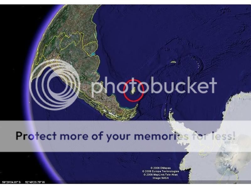
Originally posted by Unknownsoul
I found the hole on the island in the red circle
Thats the Falkland islands its a British colony and there is no hole there other than the ones made when Britain wen to war with Argentina in 1982. As for that lack of information the hole at the north pole no satellites scan that area it involves a pole fly over and just not worth tasking a satellite to do it. Most satellite imaging leaves holes at north and south pole.
new topics
-
Are you ready for the return of Jesus Christ? Have you been cleansed by His blood?
Religion, Faith, And Theology: 7 minutes ago -
Chronological time line of open source information
History: 1 hours ago -
A man of the people
Diseases and Pandemics: 2 hours ago -
Ramblings on DNA, blood, and Spirit.
Philosophy and Metaphysics: 3 hours ago -
4 plans of US elites to defeat Russia
New World Order: 4 hours ago -
Thousands Of Young Ukrainian Men Trying To Flee The Country To Avoid Conscription And The War
Other Current Events: 8 hours ago -
12 jurors selected in Trump criminal trial
US Political Madness: 10 hours ago -
Iran launches Retalliation Strike 4.18.24
World War Three: 10 hours ago -
Israeli Missile Strikes in Iran, Explosions in Syria + Iraq
World War Three: 11 hours ago
top topics
-
George Knapp AMA on DI
Area 51 and other Facilities: 17 hours ago, 26 flags -
Israeli Missile Strikes in Iran, Explosions in Syria + Iraq
World War Three: 11 hours ago, 17 flags -
Thousands Of Young Ukrainian Men Trying To Flee The Country To Avoid Conscription And The War
Other Current Events: 8 hours ago, 6 flags -
Iran launches Retalliation Strike 4.18.24
World War Three: 10 hours ago, 6 flags -
Not Aliens but a Nazi Occult Inspired and then Science Rendered Design.
Aliens and UFOs: 17 hours ago, 5 flags -
12 jurors selected in Trump criminal trial
US Political Madness: 10 hours ago, 4 flags -
4 plans of US elites to defeat Russia
New World Order: 4 hours ago, 2 flags -
A man of the people
Diseases and Pandemics: 2 hours ago, 2 flags -
Chronological time line of open source information
History: 1 hours ago, 2 flags -
Ramblings on DNA, blood, and Spirit.
Philosophy and Metaphysics: 3 hours ago, 1 flags
active topics
-
4 plans of US elites to defeat Russia
New World Order • 22 • : Greazel -
Israeli Missile Strikes in Iran, Explosions in Syria + Iraq
World War Three • 54 • : CarlLaFong -
Are you ready for the return of Jesus Christ? Have you been cleansed by His blood?
Religion, Faith, And Theology • 0 • : TheGoodNews -
12 jurors selected in Trump criminal trial
US Political Madness • 30 • : RazorV66 -
Thousands Of Young Ukrainian Men Trying To Flee The Country To Avoid Conscription And The War
Other Current Events • 5 • : JAY1980 -
Meet Catturd who has been swatted 3 times
General Conspiracies • 22 • : 7dayhome -
A man of the people
Diseases and Pandemics • 6 • : PrivateAngel -
In the Beginning was the Word, and the Word was with God, and the Word was God
Religion, Faith, And Theology • 28 • : TheGoodNews -
Biden--My Uncle Was Eaten By Cannibals
US Political Madness • 48 • : CarlLaFong -
The Truth About Jesus
Conspiracies in Religions • 270 • : TheGoodNews
1